
Washington State Route 162
Encyclopedia
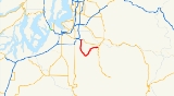
State Route 162 is a 17.37 miles (28 km) long state highway
located entirely in Pierce County
, Washington, United States.
south of Sumner
and east of the SR 167 / SR 410 interchange. The highway travels south and crosses a branch of the White River, traveling through lightly populated rural Pierce County
. SR 162 continues southeasterly, crossing the puyallup River, passing by the High Cedars Golf Club and housing development, entering the city of Orting
. The highway serves as the main thoroughfare through town and exits turning northeasterly through woodlands, crossing the carbon River. The highway turns more easterly as it enters South Prairie
. After exiting town the highway winds south of White River High School before terminating at SR 165
.
, Washington.
{| class="wikitable"
|-
!scope=col|Mile
!scope=col|Destinations
!scope=col|Notes
|-
|0.00–0.08
|
|Interchange
, western terminus
|-
|17.37
|
|Eastern terminus
State highway
State highway, state road or state route can refer to one of three related concepts, two of them related to a state or provincial government in a country that is divided into states or provinces :#A...
located entirely in Pierce County
Pierce County, Washington
right|thumb|[[Tacoma, Washington|Tacoma]] - Seat of Pierce CountyPierce County is the second most populous county in the U.S. state of Washington. Formed out of Thurston County on December 22, 1852, by the legislature of Oregon Territory...
, Washington, United States.
Route description
SR 162 begins at a diamond interchange with SR 410Washington State Route 410
State Route 410 is a long state highway that traverses Pierce, King, and Yakima counties in the U.S. state of Washington. It begins at an interchange with SR 167 in Sumner and travels southeast across the Cascade Range to a junction with U.S. Route 12 in Naches...
south of Sumner
Sumner, Washington
Sumner is a city in northern Pierce County, Washington, United States. The population was 9,451 at the 2010 census. Nearby cities include Puyallup to the west, Auburn to the north, and Enumclaw to the east.-History:...
and east of the SR 167 / SR 410 interchange. The highway travels south and crosses a branch of the White River, traveling through lightly populated rural Pierce County
Pierce County, Washington
right|thumb|[[Tacoma, Washington|Tacoma]] - Seat of Pierce CountyPierce County is the second most populous county in the U.S. state of Washington. Formed out of Thurston County on December 22, 1852, by the legislature of Oregon Territory...
. SR 162 continues southeasterly, crossing the puyallup River, passing by the High Cedars Golf Club and housing development, entering the city of Orting
Orting, Washington
Orting is a city in Pierce County, Washington, United States. The population as of the 2010 census is 6,746, according to the City of Orting.- History :...
. The highway serves as the main thoroughfare through town and exits turning northeasterly through woodlands, crossing the carbon River. The highway turns more easterly as it enters South Prairie
South Prairie, Washington
South Prairie is a town in Pierce County, Washington, United States. The population was 434 at the 2010 census.-History:South Prairie was platted in 1888 by Frank Bisson. It was named because of its location, south of Connell's and Porter's prairies...
. After exiting town the highway winds south of White River High School before terminating at SR 165
Washington State Route 165
State Route 165 is a numbered state highway in Washington, United States. Its northern terminus is at State Route 410 in Buckley. Its southern terminus is at the Mount Rainier National Park boundary near Mowich Lake.-Route description:...
.
Major intersections
The entire route is located in Pierce CountyPierce County, Washington
right|thumb|[[Tacoma, Washington|Tacoma]] - Seat of Pierce CountyPierce County is the second most populous county in the U.S. state of Washington. Formed out of Thurston County on December 22, 1852, by the legislature of Oregon Territory...
, Washington.
{| class="wikitable"
|-
!scope=col|Mile
!scope=col|Destinations
!scope=col|Notes
|-
|0.00–0.08
|
|Interchange
Interchange (road)
In the field of road transport, an interchange is a road junction that typically uses grade separation, and one or more ramps, to permit traffic on at least one highway to pass through the junction without directly crossing any other traffic stream. It differs from a standard intersection, at which...
, western terminus
|-
|17.37
|
|Eastern terminus