
Carbon River
Encyclopedia
The Carbon River is a river
in the U.S. state
of Washington. It flows about 30 miles (48 km) from its source
, the Carbon Glacier
on Mount Rainier
, to join the Puyallup River
at Orting
.
Charles Wilkes
called the river the "Upthascap River", but after the discovery of coal along its banks in 1876 the river was renamed "Carbon".
. The river's upper reach is contained within Mount Rainier National Park
. Some of the river's headwater tributary streams include Cataract Creek and Spukwush Creek. The Carbon River quickly enters a broad glacial valley in which it deposits thick layers of glacial sediment. This causes the river to meander and become braided.
After flowing by Mother Mountain on the west and Chenuis Mountain on the east, the Carbon River reaches Ipsut Creek and the national park campground of Ipsut Creek Campground. This was also the end of the Carbon River Road entrance to Mount Rainier National Park before the 2006 floods washed out portions of the road. Below Ipsut Creek the Carbon River is joined by Chenuis Creek from the north and Green Creek from the south. Shortly after these confluences the river exits Mount Rainier National Park. Carbon Ridge and its high summit Old Baldy Mountain, lie to the north. Tolmie Creek, flowing down from Tolmie Peak
, joins the Carbon River from the south.
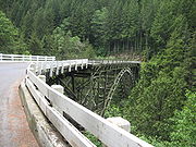
Having run generally northwest, the Carbon River turns more directly west until it is joined by Evans Creek just before the small settlement of Fairfax. From Fairfax to Carbonado the Carbon River flows north through a narrow gorge, with Gleason Hill to the east and Wingate Hill to the west.
After passing Carbonado and receiving the tributary Lily Creek, the river valley broadens again and the Carbon River resumes its generally braided and meandering pattern. It turns west, flowing through an increasingly broad floodplain to the town of Crocker, where the river is joined by one of its main tributaries, South Prairie Creek. Just below Crocker another major tributary, Voight Creek, joins.
Below Crocker the Carbon River flows northwest to join the Puyallup River. The city of Orting is located at the confluence, in the floodplain between the Carbon and Puyallup rivers.
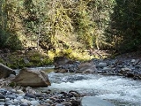
such as silt and gravel. After emerging from the Carbon Glacier the Carbon River flows through a broad glacier-carved valley where thick sediment deposits in the stream bed
create sand and gravel bars causing the river to become complexly braided
, meander
ing, and flood-prone. The river frequently shifts channels and creates new ones in its valley. Between Fairfax and Carbonado
the Carbon River flows through a narrow gorge (right) before emerging into another broad flood-prone valley near Crocker and Orting.
environment.
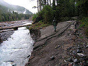 Flooding occurs frequently in the upper Carbon River valley. In 2006, a major flood resulted in the river forming new stream channels and in the process washing-out a portion of the Carbon River Road. The road is the main entrance to the northwestern part of Mount Rainier National Park. Part of the road essentially became a new channel of the river. Other parts of the road were washed away.
As of 2008, the Carbon River Road was closed to motorized access at the entrance station. That added almost 11 miles (17.7 km) round trip for any hikes that formerly began at the Ipsut Creek Campground. The Ipsut Creek campground is permanently closed to vehicle camping, and requires a back country camping permit for overnight use. Flood and/or high water conditions continue to represent dangers to users and can occur with little warning.
s.
River
A river is a natural watercourse, usually freshwater, flowing towards an ocean, a lake, a sea, or another river. In a few cases, a river simply flows into the ground or dries up completely before reaching another body of water. Small rivers may also be called by several other names, including...
in the U.S. state
U.S. state
A U.S. state is any one of the 50 federated states of the United States of America that share sovereignty with the federal government. Because of this shared sovereignty, an American is a citizen both of the federal entity and of his or her state of domicile. Four states use the official title of...
of Washington. It flows about 30 miles (48 km) from its source
Source (river or stream)
The source or headwaters of a river or stream is the place from which the water in the river or stream originates.-Definition:There is no universally agreed upon definition for determining a stream's source...
, the Carbon Glacier
Carbon Glacier
Carbon Glacier is an album by Laura Veirs, released in 2004. The song Rapture was heard during the episode "Save Me", from the first season of Grey's Anatomy.-Track listing:#"Ether Sings" – 3:44#"Icebound Stream" – 3:04#"Rapture" – 3:06...
on Mount Rainier
Mount Rainier
Mount Rainier is a massive stratovolcano located southeast of Seattle in the state of Washington, United States. It is the most topographically prominent mountain in the contiguous United States and the Cascade Volcanic Arc, with a summit elevation of . Mt. Rainier is considered one of the most...
, to join the Puyallup River
Puyallup River
The Puyallup River is a river in the U.S. state of Washington. About long, it is formed by glaciers on the west side of Mount Rainier. It flows generally northwest, emptying into Commencement Bay, part of Puget Sound...
at Orting
Orting, Washington
Orting is a city in Pierce County, Washington, United States. The population as of the 2010 census is 6,746, according to the City of Orting.- History :...
.
Charles Wilkes
Charles Wilkes
Charles Wilkes was an American naval officer and explorer. He led the United States Exploring Expedition, 1838-1842 and commanded the ship in the Trent Affair during the American Civil War...
called the river the "Upthascap River", but after the discovery of coal along its banks in 1876 the river was renamed "Carbon".
Course
The source of the Carbon River is the Carbon Glacier on the north side of Mount Rainier in the Cascade RangeCascade Range
The Cascade Range is a major mountain range of western North America, extending from southern British Columbia through Washington and Oregon to Northern California. It includes both non-volcanic mountains, such as the North Cascades, and the notable volcanoes known as the High Cascades...
. The river's upper reach is contained within Mount Rainier National Park
Mount Rainier National Park
Mount Rainier National Park is a United States National Park located in southeast Pierce County and northeast Lewis County in Washington state. It was one of the US's earliest National Parks, having been established on March 2, 1899 as the fifth national park in the United States. The park contains...
. Some of the river's headwater tributary streams include Cataract Creek and Spukwush Creek. The Carbon River quickly enters a broad glacial valley in which it deposits thick layers of glacial sediment. This causes the river to meander and become braided.
After flowing by Mother Mountain on the west and Chenuis Mountain on the east, the Carbon River reaches Ipsut Creek and the national park campground of Ipsut Creek Campground. This was also the end of the Carbon River Road entrance to Mount Rainier National Park before the 2006 floods washed out portions of the road. Below Ipsut Creek the Carbon River is joined by Chenuis Creek from the north and Green Creek from the south. Shortly after these confluences the river exits Mount Rainier National Park. Carbon Ridge and its high summit Old Baldy Mountain, lie to the north. Tolmie Creek, flowing down from Tolmie Peak
Tolmie Peak
Tolmie Peak is a peak in the Mount Rainier area of the Cascade Range, in the U.S. state of Washington. It is located northwest of Mowich Lake, in the northwest part of Mount Rainier National Park....
, joins the Carbon River from the south.
Having run generally northwest, the Carbon River turns more directly west until it is joined by Evans Creek just before the small settlement of Fairfax. From Fairfax to Carbonado the Carbon River flows north through a narrow gorge, with Gleason Hill to the east and Wingate Hill to the west.
After passing Carbonado and receiving the tributary Lily Creek, the river valley broadens again and the Carbon River resumes its generally braided and meandering pattern. It turns west, flowing through an increasingly broad floodplain to the town of Crocker, where the river is joined by one of its main tributaries, South Prairie Creek. Just below Crocker another major tributary, Voight Creek, joins.
Below Crocker the Carbon River flows northwest to join the Puyallup River. The city of Orting is located at the confluence, in the floodplain between the Carbon and Puyallup rivers.
Geology
Formed by glacial meltwater, the Carbon River contains a heavy load of sedimentSediment
Sediment is naturally occurring material that is broken down by processes of weathering and erosion, and is subsequently transported by the action of fluids such as wind, water, or ice, and/or by the force of gravity acting on the particle itself....
such as silt and gravel. After emerging from the Carbon Glacier the Carbon River flows through a broad glacier-carved valley where thick sediment deposits in the stream bed
Stream bed
A stream bed is the channel bottom of a stream, river or creek; the physical confine of the normal water flow. The lateral confines or channel margins, during all but flood stage, are known as the stream banks or river banks. In fact, a flood occurs when a stream overflows its banks and flows onto...
create sand and gravel bars causing the river to become complexly braided
Braided river
A braided river is one of a number of channel types and has a channel that consists of a network of small channels separated by small and often temporary islands called braid bars or, in British usage, aits or eyots. Braided streams occur in rivers with high slope and/or large sediment load...
, meander
Meander
A meander in general is a bend in a sinuous watercourse. A meander is formed when the moving water in a stream erodes the outer banks and widens its valley. A stream of any volume may assume a meandering course, alternately eroding sediments from the outside of a bend and depositing them on the...
ing, and flood-prone. The river frequently shifts channels and creates new ones in its valley. Between Fairfax and Carbonado
Carbonado, Washington
Carbonado is a town in Pierce County, Washington, United States. The population was 610 at the 2010 census.-History:* This history has been condensed. For a more thorough history of Carbonado and the surrounding area read, Carbon River Coal Country.*...
the Carbon River flows through a narrow gorge (right) before emerging into another broad flood-prone valley near Crocker and Orting.
Natural history
The Carbon River valley receives about 70-90 inches (1,778-2,286 mm) of rain per year, resulting in a temperate rain forestTemperate rain forest
Temperate rainforests are coniferous or broadleaf forests that occur in the temperate zone and receive high rainfall.-Definition:For temperate rain forests of North America, Alaback's definition is widely recognized:-Global distribution:...
environment.
Floods
As of 2008, the Carbon River Road was closed to motorized access at the entrance station. That added almost 11 miles (17.7 km) round trip for any hikes that formerly began at the Ipsut Creek Campground. The Ipsut Creek campground is permanently closed to vehicle camping, and requires a back country camping permit for overnight use. Flood and/or high water conditions continue to represent dangers to users and can occur with little warning.
Lahars
As with other rivers flowing from Mount Rainier's glaciers, the Carbon River valley is at risk of laharLahar
A lahar is a type of mudflow or debris flow composed of a slurry of pyroclastic material, rocky debris, and water. The material flows down from a volcano, typically along a river valley. The term is a shortened version of "berlahar" which originated in the Javanese language of...
s.