
Old Ford, London
Encyclopedia
Old Ford is an area in the London Borough of Tower Hamlets
and traditionally considered part of Bow
.
, with a rising population in the Victorian era
, it did become an independent parish, but civil administration has always been associated with Bow
.
, Old Street
, through Bethnal Green
to Old Ford and thence across a causeway through the marshes known as Wanstead Slip (actually in Leyton
). The route then continued through Essex
to Colchester
. At this time the Lea was a wide fast flowing river and the tidal estuary stretched as far as Hackney Wick
.
Colchester was where the Romans set up their initial capital for their occupation, and the road was upgraded to run from the area of London Bridge
as one of the first paved Roman roads in Britain
. Evidence has been found of a late Roman
settlement at Old Ford dating from the 4th and 5th centuries. Excavations in 2002–3 discovered a substantial 'ribbon' development along the line of the road, surrounded by fields. Near the river there was evidence for a cluster of wooden buildings dominated by a large open-ended barn. Large amounts of cattle bone were also discovered, suggesting butchery to supply the London market. The Lea was thought to be used to supply Roman London with agricultural products and pottery from Hertsfordhire and the north. Old Ford was where the goods were transferred to continue their journey into London by wagon.
In 1110, Matilda
, wife of Henry I
, reputedly took a tumble at the ford on her way to Barking Abbey
and ordered a distinctively bow-shaped three-arched bridge to be built over the River Lea, The like of which had not been seen before. The building of the bridge at Bow
didn't leave Old Ford as a backwater and the ford continued to be well used, but it was in an isolated and rural area and the local population centre moved to Bow in the middle ages
. Old Ford was one of the sites of one of the many water mills in the area that supplied flour to the bakers of Stratforde-atte-Bow, and hence bread to the City. Due to their isolation residents were given dispensation to worship in the chapel of ease
at Stratforde-atte-Bow, later Bow Church
, to save the often difficult journey to the parish church of St Dunstan's at Stepney
.
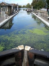
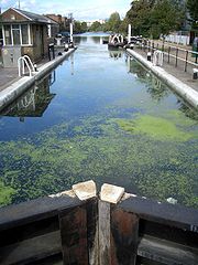
A lock and weir
now exist on the Lee Navigation near where the ford used to be. This lies at the end of 'Hackney Cut', an 18th century artificial channel and the natural channel (known as the Waterworks River) rejoins the channel below the lock.
conurbation, with large estates of relatively poor houses and much poverty. These were built to serve the new factories on the Lea and Lee Navigation and to serve the new railways.
had a line through the area with a station at Old Ford railway station
. The line was badly damaged during World War II
and never reopened. The station buildings were demolished in the early 1960s.
The railway line is expected to reopen as a part of the Crossrail
project but no additional stations are planned to serve the area.
in Ewart Place.
The nearest London Overground station
is Hackney Wick
The nearest Docklands Light Railway station is Pudding Mill Lane
. (Stratford)
To the south, the nearest London Underground station is Bromley-by-Bow
on the District Line
.
Access to the Hertford Union Canal
is via the tow-path from Wick Road at St Marks Gate (Victoria Park). East leads to the Lee Navigation where proceeding north leads to Hackney Marshes
. As this latter is within the Olympic Park
the tow-path may be closed unpredictably while building works are undertaken. Turning south along the Lea leads through Bow Locks
, into Bow Creek
and thence to the River Thames
, but the tow-path can also often be blocked. West from Wick Road leads to the Hertford Union junction where the canal joins the Regent's Canal
, near Mile End
.
Old Ford Club fun site
London Borough of Tower Hamlets
The London Borough of Tower Hamlets is a London borough to the east of the City of London and north of the River Thames. It is in the eastern part of London and covers much of the traditional East End. It also includes much of the redeveloped Docklands region of London, including West India Docks...
and traditionally considered part of Bow
Bow, London
Bow is an area of London, England, United Kingdom in the London Borough of Tower Hamlets. It is a built-up, mostly residential district located east of Charing Cross, and is a part of the East End.-Bridges at Bowe:...
.
Administration and boundaries
Historically, Old Ford was a cluster of houses and a mill, around the location of the ford. It formed a part of the medieval parish of StepneyStepney (parish)
Stepney was an ancient civil and ecclesiastical parish in the historic county of Middlesex to the east and north east of the City of London, England.-Origins:...
, with a rising population in the Victorian era
Victorian era
The Victorian era of British history was the period of Queen Victoria's reign from 20 June 1837 until her death on 22 January 1901. It was a long period of peace, prosperity, refined sensibilities and national self-confidence...
, it did become an independent parish, but civil administration has always been associated with Bow
Bow, London
Bow is an area of London, England, United Kingdom in the London Borough of Tower Hamlets. It is a built-up, mostly residential district located east of Charing Cross, and is a part of the East End.-Bridges at Bowe:...
.
Old Ford
Old Ford, as the name suggests, was the ancient most downstream crossing point of the River Lea. This was part of a pre-Roman route that followed the modern Oxford StreetOxford Street
Oxford Street is a major thoroughfare in the City of Westminster in the West End of London, United Kingdom. It is Europe's busiest shopping street, as well as its most dense, and currently has approximately 300 shops. The street was formerly part of the London-Oxford road which began at Newgate,...
, Old Street
Old Street
Old Street is a street in east London that runs west to east from Goswell Road in Clerkenwell, in the London Borough of Islington, to the crossroads where it intersects with Shoreditch High Street , Kingsland Road and Hackney Road in Shoreditch in the London Borough of Hackney.The nearest...
, through Bethnal Green
Bethnal Green
Bethnal Green is a district of the East End of London, England and part of the London Borough of Tower Hamlets, with the far northern parts falling within the London Borough of Hackney. Located northeast of Charing Cross, it was historically an agrarian hamlet in the ancient parish of Stepney,...
to Old Ford and thence across a causeway through the marshes known as Wanstead Slip (actually in Leyton
Leyton
Leyton is an area of north-east London and part of the London Borough of Waltham Forest, located north east of Charing Cross. It borders Walthamstow and Leytonstone; Stratford in Newham; and Homerton and Lower Clapton in the London Borough of Hackney....
). The route then continued through Essex
Essex
Essex is a ceremonial and non-metropolitan county in the East region of England, and one of the home counties. It is located to the northeast of Greater London. It borders with Cambridgeshire and Suffolk to the north, Hertfordshire to the west, Kent to the South and London to the south west...
to Colchester
Colchester
Colchester is an historic town and the largest settlement within the borough of Colchester in Essex, England.At the time of the census in 2001, it had a population of 104,390. However, the population is rapidly increasing, and has been named as one of Britain's fastest growing towns. As the...
. At this time the Lea was a wide fast flowing river and the tidal estuary stretched as far as Hackney Wick
Hackney Wick
Hackney Wick is an area straddling the boundary between the London Borough of Hackney and the London Borough of Tower Hamlets in east London. It is an inner-city development situated 5 miles northeast of Charing Cross...
.
Colchester was where the Romans set up their initial capital for their occupation, and the road was upgraded to run from the area of London Bridge
London Bridge
London Bridge is a bridge over the River Thames, connecting the City of London and Southwark, in central London. Situated between Cannon Street Railway Bridge and Tower Bridge, it forms the western end of the Pool of London...
as one of the first paved Roman roads in Britain
Roman Britain
Roman Britain was the part of the island of Great Britain controlled by the Roman Empire from AD 43 until ca. AD 410.The Romans referred to the imperial province as Britannia, which eventually comprised all of the island of Great Britain south of the fluid frontier with Caledonia...
. Evidence has been found of a late Roman
Roman Britain
Roman Britain was the part of the island of Great Britain controlled by the Roman Empire from AD 43 until ca. AD 410.The Romans referred to the imperial province as Britannia, which eventually comprised all of the island of Great Britain south of the fluid frontier with Caledonia...
settlement at Old Ford dating from the 4th and 5th centuries. Excavations in 2002–3 discovered a substantial 'ribbon' development along the line of the road, surrounded by fields. Near the river there was evidence for a cluster of wooden buildings dominated by a large open-ended barn. Large amounts of cattle bone were also discovered, suggesting butchery to supply the London market. The Lea was thought to be used to supply Roman London with agricultural products and pottery from Hertsfordhire and the north. Old Ford was where the goods were transferred to continue their journey into London by wagon.
In 1110, Matilda
Edith of Scotland
Matilda of Scotland , born Edith, was the first wife and Queen consort of Henry I of England.-Early life:Matilda was born around 1080 in Dunfermline, the daughter of Malcolm III of Scotland and Saint Margaret. She was christened Edith, and Robert Curthose stood as godfather at the ceremony...
, wife of Henry I
Henry I of England
Henry I was the fourth son of William I of England. He succeeded his elder brother William II as King of England in 1100 and defeated his eldest brother, Robert Curthose, to become Duke of Normandy in 1106...
, reputedly took a tumble at the ford on her way to Barking Abbey
Barking Abbey
The ruined remains of Barking Abbey are situated in Barking in the London Borough of Barking and Dagenham in east London, England, and now form a public open space.- History :...
and ordered a distinctively bow-shaped three-arched bridge to be built over the River Lea, The like of which had not been seen before. The building of the bridge at Bow
Bow, London
Bow is an area of London, England, United Kingdom in the London Borough of Tower Hamlets. It is a built-up, mostly residential district located east of Charing Cross, and is a part of the East End.-Bridges at Bowe:...
didn't leave Old Ford as a backwater and the ford continued to be well used, but it was in an isolated and rural area and the local population centre moved to Bow in the middle ages
Middle Ages
The Middle Ages is a periodization of European history from the 5th century to the 15th century. The Middle Ages follows the fall of the Western Roman Empire in 476 and precedes the Early Modern Era. It is the middle period of a three-period division of Western history: Classic, Medieval and Modern...
. Old Ford was one of the sites of one of the many water mills in the area that supplied flour to the bakers of Stratforde-atte-Bow, and hence bread to the City. Due to their isolation residents were given dispensation to worship in the chapel of ease
Chapel of ease
A chapel of ease is a church building other than the parish church, built within the bounds of a parish for the attendance of those who cannot reach the parish church conveniently....
at Stratforde-atte-Bow, later Bow Church
Bow Church
Bow Church is the parish church of St Mary and Holy Trinity, Stratford, Bow. It is located on an island site in Bow Road , in Bow, London Borough of Tower Hamlets. There has been a church on the same site for approximately 700 years...
, to save the often difficult journey to the parish church of St Dunstan's at Stepney
Stepney
Stepney is a district of the London Borough of Tower Hamlets in London's East End that grew out of a medieval village around St Dunstan's church and the 15th century ribbon development of Mile End Road...
.
A lock and weir
Old Ford Lock
Old Ford Lock is a paired lock and weir on the River Lee Navigation, in the London Borough of Tower Hamlets, England. It is at Bow on the east side of London...
now exist on the Lee Navigation near where the ford used to be. This lies at the end of 'Hackney Cut', an 18th century artificial channel and the natural channel (known as the Waterworks River) rejoins the channel below the lock.
Victorian era
Farming and market gardening prevailed in the district until the 19th century when Old Ford became a part of the seamless East EndEast End of London
The East End of London, also known simply as the East End, is the area of London, England, United Kingdom, east of the medieval walled City of London and north of the River Thames. Although not defined by universally accepted formal boundaries, the River Lea can be considered another boundary...
conurbation, with large estates of relatively poor houses and much poverty. These were built to serve the new factories on the Lea and Lee Navigation and to serve the new railways.
Railways
The North London RailwayNorth London Railway
The North London Railway was a railway company that opened lines connecting the north of London to the East and West India Docks. The main east to west route is now part the North London Line. Other lines operated by the company fell into disuse, but were later revived as part of the Docklands...
had a line through the area with a station at Old Ford railway station
Old Ford railway station
Old Ford railway station was a former railway station in Old Ford, north of Bow, London. It was on the North London Railway between Victoria Park and Bow stations; the station was located on Old Ford Road, east of the junction with Lefevre Road .It opened in 1867 but was closed in 1944 after damage...
. The line was badly damaged during World War II
World War II
World War II, or the Second World War , was a global conflict lasting from 1939 to 1945, involving most of the world's nations—including all of the great powers—eventually forming two opposing military alliances: the Allies and the Axis...
and never reopened. The station buildings were demolished in the early 1960s.
Today
As of 2010 the Old Ford is again becoming desirable because of its streets of Victorian housing and improved transport links. The coming of the London 2012 Olympics is expected to provide an impetus to regeneration of the area.The railway line is expected to reopen as a part of the Crossrail
Crossrail
Crossrail is a project to build a major new railway link under central London. The name refers to the first of two routes which are the responsibility of Crossrail Ltd. It is based on an entirely new east-west tunnel with a central section from to Liverpool Street station...
project but no additional stations are planned to serve the area.
Communal facilities
Local council facilities are grouped around Roman Road market. The local library, now called an Idea Store, is situated in Gladstone Place. A community and tenants' hall is nearby. Access to council services is dealt with by the Bow and North Poplar One Stop ShopOne stop shop
One Stop may refer to:* One Stop, the smallest store format of TescoOne Stop Shop is a term used by many local authorities in the United Kingdom to describe the facility they offer for their residents to discuss and arrange services with officers of the authority...
in Ewart Place.
Education
Nearby places
- BowBow, LondonBow is an area of London, England, United Kingdom in the London Borough of Tower Hamlets. It is a built-up, mostly residential district located east of Charing Cross, and is a part of the East End.-Bridges at Bowe:...
- Hackney WickHackney WickHackney Wick is an area straddling the boundary between the London Borough of Hackney and the London Borough of Tower Hamlets in east London. It is an inner-city development situated 5 miles northeast of Charing Cross...
- StratfordStratford, LondonStratford is a place in the London Borough of Newham, England. It is located east northeast of Charing Cross and is one of the major centres identified in the London Plan. It was historically an agrarian settlement in the ancient parish of West Ham, which transformed into an industrial suburb...
- Victoria ParkVictoria Park, East LondonVictoria Park is 86.18 hectares of open space that stretches out across part of the East End of London, England bordering parts of Bethnal Green, Hackney, and Bow, such as along Old Ford Road, London E3 and Victoria Park Road E9. The park is entirely within the London Borough of Tower Hamlets...
The nearest London Overground station
London Overground
London Overground is a suburban rail network in London and Hertfordshire. It has been operated by London Overground Rail Operations since 2007 as part of the National Rail network, under the franchise control and branding of Transport for London...
is Hackney Wick
Hackney Wick railway station
Hackney Wick railway station is on the North London Line in the London Borough of Hackney, on the northern side of the boundary between Hackney and the London Borough of Tower Hamlets, in east London. It is in Travelcard Zone 2. The station and all trains serving it are operated by London Overground...
The nearest Docklands Light Railway station is Pudding Mill Lane
Pudding Mill Lane DLR station
Pudding Mill Lane DLR station is a station on the Docklands Light Railway in east London. It is situated in the road of the same name in a light industrial area...
. (Stratford)
To the south, the nearest London Underground station is Bromley-by-Bow
Bromley-by-Bow tube station
Bromley-by-Bow tube station is a London Underground station on the Blackwall Tunnel Northern Approach Road in the Bromley-by-Bow neighbourhood of the London Borough of Tower Hamlets in east London, England. The station is on the District and Hammersmith & City lines, with both services sharing a...
on the District Line
District Line
The District line is a line of the London Underground, coloured green on the Tube map. It is a "sub-surface" line, running through the central area in shallow cut-and-cover tunnels. It is the busiest of the sub-surface lines. Out of the 60 stations served, 25 are underground...
.
Access to the Hertford Union Canal
Hertford Union Canal
The Hertford Union Canal or Duckett's Canal is a short stretch of canal in the London Borough of Tower Hamlets in east London. It connects the Regent's Canal to the Lee Navigation. It was opened in 1830 but quickly proved to be a commercial failure...
is via the tow-path from Wick Road at St Marks Gate (Victoria Park). East leads to the Lee Navigation where proceeding north leads to Hackney Marshes
Hackney Marshes
Hackney Marshes is an area of grassland on the western bank of the River Lea in the London Borough of Hackney. It was incorporated into the Lee Valley Park in 1967...
. As this latter is within the Olympic Park
2012 Summer Olympics
The 2012 Summer Olympic Games, officially known as the "London 2012 Olympic Games", are scheduled to take place in London, England, United Kingdom from 27 July to 12 August 2012...
the tow-path may be closed unpredictably while building works are undertaken. Turning south along the Lea leads through Bow Locks
Bow Locks
Bow Locks is a set of bi-directional locks in the London Borough of Tower Hamlets. The locks link the tidal Bow Creek to the River Lee Navigation, which is a canalised river. These locks were first built in 1850 and then rebuilt in 1930, at the same time as the Prescott Channel was cut nearby...
, into Bow Creek
Bow Creek
Bow Creek is a long tidal estuary of the River Lea and is part of the Bow Back Rivers. Below Bow Locks the creek forms the boundary between the London Boroughs of Newham and Tower Hamlets, in east London....
and thence to the River Thames
River Thames
The River Thames flows through southern England. It is the longest river entirely in England and the second longest in the United Kingdom. While it is best known because its lower reaches flow through central London, the river flows alongside several other towns and cities, including Oxford,...
, but the tow-path can also often be blocked. West from Wick Road leads to the Hertford Union junction where the canal joins the Regent's Canal
Regent's Canal
Regent's Canal is a canal across an area just north of central London, England. It provides a link from the Paddington arm of the Grand Union Canal, just north-west of Paddington Basin in the west, to the Limehouse Basin and the River Thames in east London....
, near Mile End
Mile End
Mile End is an area within the East End of London, England, and part of the London Borough of Tower Hamlets. It is located east-northeast of Charing Cross...
.
See also
- A number of artificial waterways cross the district. Old Ford Lock could refer to:
- On the Lee Navigation, to the east of the district
- Old Ford LockOld Ford LockOld Ford Lock is a paired lock and weir on the River Lee Navigation, in the London Borough of Tower Hamlets, England. It is at Bow on the east side of London...
- Old Ford Lock
- On the Lee Navigation, to the east of the district
-
- On the Regent's CanalRegent's CanalRegent's Canal is a canal across an area just north of central London, England. It provides a link from the Paddington arm of the Grand Union Canal, just north-west of Paddington Basin in the west, to the Limehouse Basin and the River Thames in east London....
, to the west of Victoria ParkVictoria Park, East LondonVictoria Park is 86.18 hectares of open space that stretches out across part of the East End of London, England bordering parts of Bethnal Green, Hackney, and Bow, such as along Old Ford Road, London E3 and Victoria Park Road E9. The park is entirely within the London Borough of Tower Hamlets...
- Old Ford Lock
- On the Regent's Canal
-
- On the Hertford Union CanalHertford Union CanalThe Hertford Union Canal or Duckett's Canal is a short stretch of canal in the London Borough of Tower Hamlets in east London. It connects the Regent's Canal to the Lee Navigation. It was opened in 1830 but quickly proved to be a commercial failure...
, to the south of Victoria Park- Old Ford Upper Lock
- Old Ford Middle Lock
- Old Ford Lower Lock
- On the Hertford Union Canal
Old Ford Club fun site
- East London Waterworks CompanyEast London Waterworks CompanyThe East London Waterworks Company was one of eight private water companies in London absorbed by the Metropolitan Water Board in 1904.The company was founded by Act of Parliament in 1806, and in 1845 the limits of supply were described as "all those portions of the Metropolis, and its suburbs,...