
Norman Creek
Encyclopedia
Norman Creek is a small tributary of the Brisbane River
. The headwaters of the creek are located on the northern slopes of Toohey Mountain
and Mount Gravatt in southern Brisbane
.
Edmund Lockyer
named the waterway Norman Creek in 1825.
 The creek drains the suburbs of Tarragindi
and Holland Park West
then flows northwards through Greenslopes
, Norman Park
and East Brisbane
before entering the Brisbane River at Humbug Reach.
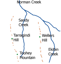
The total catchment area is 29.8 km². Coorparoo Creek in Coorparoo
is a sub-catchment of Norman Creek. Other sub-catchments include Sandy Creek and Ekibin Creek. There are four significant bridges that cross the creek.
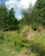
At Stones Corner the tidal part of the creek funnels out into a thin gully. From here south, parts of the creek have been channelised into cement drains.
Invasion by weeds, the dumping of rubbish and in the past, sewage discharges have posed problems for the environmental health of this highly urbanised waterway. Volunteer conservation groups are attempting to redress the problems.
Brisbane River
The Brisbane River is the longest river in south east Queensland, Australia, and flows through the city of Brisbane, before emptying into Moreton Bay. John Oxley was the first European to explore the river who named it after the Governor of New South Wales, Thomas Brisbane in 1823...
. The headwaters of the creek are located on the northern slopes of Toohey Mountain
Toohey Mountain
Toohey Mountain is a medium sized mountain at the eastern side of the City of Brisbane's suburb of Moorooka. The rise was named after James Toohey, an Irish born Sydneysider who made his wealth in the California gold rush, before settling in the newly formed state of Queensland.To the north of the...
and Mount Gravatt in southern Brisbane
Brisbane
Brisbane is the capital and most populous city in the Australian state of Queensland and the third most populous city in Australia. Brisbane's metropolitan area has a population of over 2 million, and the South East Queensland urban conurbation, centred around Brisbane, encompasses a population of...
.
Edmund Lockyer
Edmund Lockyer
Edmund Lockyer, – 10 June 1860) was a British soldier and explorer of Australia.Born in Plymouth, Devon, Lockyer was son of Thomas Lockyer, a sailmaker, and his wife Ann, née Grose. Lockyer began his army career as an ensign in the 19th Regiment in June 1803, was promoted lieutenant in early 1805...
named the waterway Norman Creek in 1825.
Tarragindi, Queensland
Tarragindi is a suburb on the southern side of Brisbane, Queensland, Australia. It is represented through the Holland Park and Moorooka Ward councillors on the Brisbane City Council.-Origin of the name:...
and Holland Park West
Holland Park West, Queensland
Holland Park West is a suburb of Brisbane, Queensland, Australia. The suburb was gazetted in 1972.It is located in the inner suburbs south-east of the Brisbane central business district between the Pacific Motorway and Logan Road.-References:...
then flows northwards through Greenslopes
Greenslopes, Queensland
Greenslopes is a moderately sized suburb of the city of Brisbane, state capital of Queensland, Australia."Greenslopes" is also the name of a Queensland state electorate. The electorate contains only a small fraction of the suburb of the same name...
, Norman Park
Norman Park, Queensland
Norman Park is a suburb in Brisbane, Australia. It is located 4 km east of the Brisbane central business district.Norman Park has numerous parks and recreational areas for residents in the area...
and East Brisbane
East Brisbane, Queensland
East Brisbane is an inner suburb of Brisbane, Australia located 3 km east of the Brisbane CBD. It is predominantly residential, with some original "Queenslander" style homes, but with an increasing number of apartment blocks. Major roads include Lytton Road, Wellington Road and Latrobe...
before entering the Brisbane River at Humbug Reach.
The total catchment area is 29.8 km². Coorparoo Creek in Coorparoo
Coorparoo, Queensland
Coorparoo is a southern suburb of Brisbane, Queensland, Australia, located approximately four kilometres from the city. Surrounding suburbs include Camp Hill, Holland Park, Greenslopes, East Brisbane, Norman Park and Seven Hills.-Aboriginal history:...
is a sub-catchment of Norman Creek. Other sub-catchments include Sandy Creek and Ekibin Creek. There are four significant bridges that cross the creek.
At Stones Corner the tidal part of the creek funnels out into a thin gully. From here south, parts of the creek have been channelised into cement drains.
Invasion by weeds, the dumping of rubbish and in the past, sewage discharges have posed problems for the environmental health of this highly urbanised waterway. Volunteer conservation groups are attempting to redress the problems.