

Toohey Mountain
Encyclopedia
Mountain
Image:Himalaya_annotated.jpg|thumb|right|The Himalayan mountain range with Mount Everestrect 58 14 160 49 Chomo Lonzorect 200 28 335 52 Makalurect 378 24 566 45 Mount Everestrect 188 581 920 656 Tibetan Plateaurect 250 406 340 427 Rong River...
at the eastern side of the City of Brisbane's
Brisbane
Brisbane is the capital and most populous city in the Australian state of Queensland and the third most populous city in Australia. Brisbane's metropolitan area has a population of over 2 million, and the South East Queensland urban conurbation, centred around Brisbane, encompasses a population of...
suburb of Moorooka
Moorooka, Queensland
Moorooka is a suburb of Brisbane, the state capital of Queensland, Australia. Bordering with Toohey Forest Park, it is seven kilometres south of Brisbane's central business district...
. The rise was named after James Toohey, an Irish born Sydneysider who made his wealth in the California gold rush
California Gold Rush
The California Gold Rush began on January 24, 1848, when gold was found by James W. Marshall at Sutter's Mill in Coloma, California. The first to hear confirmed information of the gold rush were the people in Oregon, the Sandwich Islands , and Latin America, who were the first to start flocking to...
, before settling in the newly formed state of Queensland.
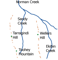
To the north of the mountain is Tarragindi Hill and Wellers Hill.
Grass Tree Ridge was the name given to the tall and long ridge that extends through parts of Tarragindi
Tarragindi, Queensland
Tarragindi is a suburb on the southern side of Brisbane, Queensland, Australia. It is represented through the Holland Park and Moorooka Ward councillors on the Brisbane City Council.-Origin of the name:...
, Salisbury
Salisbury, Queensland
Salisbury is a suburb of Brisbane, Australia. It is south of the Brisbane central business district.Salisbury was named after the residence of William Coote, an early Brisbane journalist and political figure, who lived in the area....
and Nathan
Nathan, Queensland
Nathan is a southern suburb of Brisbane, Australia. It was named in 1967 after Sir Matthew Nathan, Governor of Queensland from 1920 to 1926.Nathan is home to Toohey Forest Conservation Park, Griffith University's Nathan campus and the Queensland Sport and Athletics Centre which hosted the opening...
, towards Sunnybank
Sunnybank, Queensland
Sunnybank is now a suburb in Brisbane, Queensland, Australia much reduced in size from the previous suburb of Sunnybank. The separate Town of Sunnybank was absorbed into the City of Brisbane. This older Sunnybank area is still known locally as Sunnybank...
. Most of the mountain is included in the Toohey Forest Conservation Park.
It features many walking tracks, some of which link up with the nearby Mount Gravatt
Mount Gravatt, Queensland
Mount Gravatt is the name of both a major suburb of Brisbane, Queensland, Australia and a prominent hill in this suburb. The suburb is situated in the south-east of the city and was one of Brisbane's largest...
, the southside's tallest mountain and Griffith University
Griffith University
Griffith University is a public, coeducational, research university located in the southeastern region of the Australian state of Queensland. The university has five satellite campuses located in the Gold Coast, Logan City and in the Brisbane suburbs of Mount Gravatt, Nathan and South Bank. Current...
campus in Nathan
Nathan, Queensland
Nathan is a southern suburb of Brisbane, Australia. It was named in 1967 after Sir Matthew Nathan, Governor of Queensland from 1920 to 1926.Nathan is home to Toohey Forest Conservation Park, Griffith University's Nathan campus and the Queensland Sport and Athletics Centre which hosted the opening...
.
Toohey Mountain is the site of two small reservoirs. It lies within the Oxley Creek catchment with Rocky Waters Hole Creek draining western and southern slopes, the Norman Creek
Norman Creek
Norman Creek is a small tributary of the Brisbane River. The headwaters of the creek are located on the northern slopes of Toohey Mountain and Mount Gravatt in southern Brisbane.Edmund Lockyer named the waterway Norman Creek in 1825....
catchment to the north and Bulimba Creek's catchment to the east.
Also of note, there is an old Channel 7 rebroadcasting tower located on the Melaleuca Walking Track (about 200 m-300 m from the Madang St entrance to the Fimbriata Walking Track) which although discontinued from service for many decades has recently been restored to service as a community wireless access point by the Brisbane Mesh, a community wireless group.