

Nicobar Islands
Encyclopedia
Archipelago
An archipelago , sometimes called an island group, is a chain or cluster of islands. The word archipelago is derived from the Greek ἄρχι- – arkhi- and πέλαγος – pélagos through the Italian arcipelago...
island chain in the eastern Indian Ocean
Indian Ocean
The Indian Ocean is the third largest of the world's oceanic divisions, covering approximately 20% of the water on the Earth's surface. It is bounded on the north by the Indian Subcontinent and Arabian Peninsula ; on the west by eastern Africa; on the east by Indochina, the Sunda Islands, and...
. They are located in Southeast Asia
Southeast Asia
Southeast Asia, South-East Asia, South East Asia or Southeastern Asia is a subregion of Asia, consisting of the countries that are geographically south of China, east of India, west of New Guinea and north of Australia. The region lies on the intersection of geological plates, with heavy seismic...
, 150 km north of Aceh
Aceh
Aceh is a special region of Indonesia, located on the northern tip of the island of Sumatra. Its full name is Daerah Istimewa Aceh , Nanggroë Aceh Darussalam and Aceh . Past spellings of its name include Acheh, Atjeh and Achin...
on Sumatra
Sumatra
Sumatra is an island in western Indonesia, westernmost of the Sunda Islands. It is the largest island entirely in Indonesia , and the sixth largest island in the world at 473,481 km2 with a population of 50,365,538...
, and separated from Thailand to the east by the Andaman Sea
Andaman Sea
The Andaman Sea or Burma Sea is a body of water to the southeast of the Bay of Bengal, south of Burma, west of Thailand and east of the Andaman Islands, India; it is part of the Indian Ocean....
.
Located 1,300 km southeast of the Indian subcontinent
Indian subcontinent
The Indian subcontinent, also Indian Subcontinent, Indo-Pak Subcontinent or South Asian Subcontinent is a region of the Asian continent on the Indian tectonic plate from the Hindu Kush or Hindu Koh, Himalayas and including the Kuen Lun and Karakoram ranges, forming a land mass which extends...
, across the Bay of Bengal
Bay of Bengal
The Bay of Bengal , the largest bay in the world, forms the northeastern part of the Indian Ocean. It resembles a triangle in shape, and is bordered mostly by the Eastern Coast of India, southern coast of Bangladesh and Sri Lanka to the west and Burma and the Andaman and Nicobar Islands to the...
, they form part of the Union Territory
Union Territory
A Union Territory is a sub-national administrative division of India, in the federal framework of governance. Unlike the states of India, which have their own elected governments, union territories are ruled directly by the federal government; the President of India appoints an Administrator or...
of Andaman and Nicobar Islands, India
India
India , officially the Republic of India , is a country in South Asia. It is the seventh-largest country by geographical area, the second-most populous country with over 1.2 billion people, and the most populous democracy in the world...
.
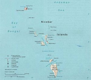
Geography
Northern Group:- Car NicobarCar NicobarCar Nicobar is the northernmost of the Nicobar Islands. It is also one of two local administrative divisions of the Indian district of Nicobar, part of the Indian union territory of Andaman and Nicobar Islands....
(126,9 km²) - Battimaly (2,01 km², uninhabited)
Central Group:
- Chaura, Chowra or Sanenyo (8,2 km²)
- TeressaTeressa (Nicobar Islands)Teressa is one of the Nicobar Islands, India. Austria and Denmark claimed Nicobar Islands as colony. Teressa is named after the Austrian Arch-duchess Maria Theresia....
or Luroo (101,4 km²) - Bompuka or Poahat (13,3 km²)
- KatchalKatchalKatchal is one of the Nicobar Islands, India. Its area is .It is approximately away from mainland and south to capital Port Blair....
(174,4 km²) - CamortaCamortaCamorta is one of the Nicobar Islands, India. Its area is 188 km²....
(188,2 km²) - NancowryNancowryNancowry refers both to a single island and to the group of adjoining islands that make up the central part of the Nicobar Islands chain, located in the northeast Indian Ocean between the Bay of Bengal and the Andaman Sea....
or Nancowrie (66,9 km²) - TrinketTrinket IslandTrinket Island is part of the Nicobar Islands chain, located in the northeast Indian Ocean between the Bay of Bengal and the Andaman Sea. It is located east of Kamorta island and, like the Nicobar Islands generally, is under the sovereignty of the nation of India...
(until 2004 86,3 km², surface greatly reduced after the Tsunami) - Laouk or "Isle of Man" (0,01 km²) (uninhabited)
- Tillangchong (16,84 km²) (uninhabited)
Southern Group (Sambelong):
- Great NicobarGreat NicobarGreat Nicobar is the largest of the Nicobar Islands of India, north of Sumatra. Indira Point, its southernmost tip, is also the southernmost point of India. The island of Sumatra is located to the south of Great Nicobar...
(1045,1 km², largest island of the Nicobars; 9,440 inhabitants in 2001) - Little NicobarLittle NicobarLittle Nicobar is one of the Nicobar Islands, India. Its area is 157 km². There are a few smaller islands of Little Nicobar's shores: Menchal, Pulomilo, Treis/Albatei, Trak/Mafuya and Meroe. The island of Katchal is located about 70 km to the north.The 2004 Indian Ocean earthquake and tsunami...
(159,1 km²; 430 inhabitants) - Kondul (4,6 km²; 150 inhabitants in 2001, evacuated in 2004)
- Pulo Milo or Pillomilo (Milo Island; 1,3 km²; 150 inhabitants)
- Meroe (0,52), Trak (0,26), Treis (0,26), Menchal (1,30), Kabra (0,52), Pigeon and Megapod (0,2) (all uninhabited)
Nature
Geology
The Nicobar Islands are part of a great island arcIsland arc
An island arc is a type of archipelago composed of a chain of volcanoes which alignment is arc-shaped, and which are situated parallel and close to a boundary between two converging tectonic plates....
created by the collision of the Indo-Australian Plate
Indo-Australian Plate
The Indo-Australian Plate is a major tectonic plate that includes the continent of Australia and surrounding ocean, and extends northwest to include the Indian subcontinent and adjacent waters...
with Eurasia
Eurasia
Eurasia is a continent or supercontinent comprising the traditional continents of Europe and Asia ; covering about 52,990,000 km2 or about 10.6% of the Earth's surface located primarily in the eastern and northern hemispheres...
. The collision lifted the Himalayas
Himalayas
The Himalaya Range or Himalaya Mountains Sanskrit: Devanagari: हिमालय, literally "abode of snow"), usually called the Himalayas or Himalaya for short, is a mountain range in Asia, separating the Indian subcontinent from the Tibetan Plateau...
and most of the Indonesian islands, and created a long arc of highlands and islands, which includes the Arakan Yoma
Arakan Yoma
The Arakan Mountains is a mountain range in western Burma , between the coast of Rakhine State and the Central Burma Basin, in which flows the Irrawaddy River...
range of Burma, the Andaman and Nicobar islands, and the islands off the west coast of Sumatra
Sumatra
Sumatra is an island in western Indonesia, westernmost of the Sunda Islands. It is the largest island entirely in Indonesia , and the sixth largest island in the world at 473,481 km2 with a population of 50,365,538...
, including the Banyak Islands
Banyak Islands
The Banyak Islands are a group of mostly uninhabited islands located between Simeulue and Nias off the western coast of Sumatra in Indonesia's Aceh Province, consisting of 99 small land masses. The largest island in the group is Tuangku , with the principal town of Alaban...
and Mentawai Islands
Mentawai Islands
The Mentawai Islands are a chain of about seventy islands and islets off the western coast of Sumatra in Indonesia. Siberut is the largest of the islands. The other major islands are Sipura, North Pagai and South Pagai . The islands lie approximately 150 km off the Sumatran coast, across the...
.
Ecology
The climate is warm and tropical, with temperatures ranging from 22 to 30°C. Rainfall is heavy due to annual monsoons and measures around 3000 to 3800 mm each year. The vegetation of the Nicobars is typically divided into the coastal mangroveMangrove
Mangroves are various kinds of trees up to medium height and shrubs that grow in saline coastal sediment habitats in the tropics and subtropics – mainly between latitudes N and S...
forests and the interior evergreen and deciduous Tropical and subtropical moist broadleaf forests
Tropical and subtropical moist broadleaf forests
Tropical and subtropical moist broadleaf forests , also known as tropical moist forests, are a tropical and subtropical forest biome....
. Additionally, several islands contain extensive inland grassland
Grassland
Grasslands are areas where the vegetation is dominated by grasses and other herbaceous plants . However, sedge and rush families can also be found. Grasslands occur naturally on all continents except Antarctica...
s, though these are thought to result from human intervention.
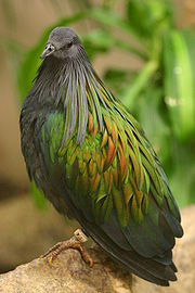
The Nicobar islands are recognized as a distinct terrestrial ecoregion, the Nicobar Islands rain forests, with many endemic
Endemic (ecology)
Endemism is the ecological state of being unique to a defined geographic location, such as an island, nation or other defined zone, or habitat type; organisms that are indigenous to a place are not endemic to it if they are also found elsewhere. For example, all species of lemur are endemic to the...
species.
As a result of lower sea levels during the ice age
Ice age
An ice age or, more precisely, glacial age, is a generic geological period of long-term reduction in the temperature of the Earth's surface and atmosphere, resulting in the presence or expansion of continental ice sheets, polar ice sheets and alpine glaciers...
s, the Andaman Islands were linked to the Southeast Asian mainland, but it is not believed that the Nicobar islands ever had a land bridge to the continent. Lower sea levels did link the islands to one another: Great Nicobar and Little Nicobar were linked to each other, and Nancowry, Chaura, Katchall, Trinka, Camorta, and the nearby smaller islands were linked to one another as well.
History
The Nicobar islands are believed to have been inhabited for thousands of years. Six indigenous Nicobarese languagesNicobarese languages
The Nicobarese languages form an isolated group of half a dozen closely related Austro-Asiatic languages, spoken by the majority of the inhabitants of the Nicobar Islands of India. They have a total of about 30,000 speakers...
are spoken on the islands, which are part of the Mon–Khmer branch of the Austroasiatic language family, which includes Mon
Mon language
The Mon language is an Austroasiatic language spoken by the Mon, who live in Burma and Thailand. Mon, like the related language Cambodian—but unlike most languages in Mainland Southeast Asia—is not tonal. Mon is spoken by more than a million people today. In recent years, usage of Mon has...
, Khmer
Khmer language
Khmer , or Cambodian, is the language of the Khmer people and the official language of Cambodia. It is the second most widely spoken Austroasiatic language , with speakers in the tens of millions. Khmer has been considerably influenced by Sanskrit and Pali, especially in the royal and religious...
and Vietnamese
Vietnamese language
Vietnamese is the national and official language of Vietnam. It is the mother tongue of 86% of Vietnam's population, and of about three million overseas Vietnamese. It is also spoken as a second language by many ethnic minorities of Vietnam...
languages of Southeast Asia
Southeast Asia
Southeast Asia, South-East Asia, South East Asia or Southeastern Asia is a subregion of Asia, consisting of the countries that are geographically south of China, east of India, west of New Guinea and north of Australia. The region lies on the intersection of geological plates, with heavy seismic...
, and the Munda languages
Munda languages
-Anderson :Gregory Anderson's 1999 proposal is as follows. Individual languages are highlighted in italics.*North Munda **Korku**Kherwarian***Santhali***Mundari*South Munda **Kharia–Juang***Juang***Kharia...
of India. An indigenous tribe living at the southern tip of Great Nicobar, called the Shompen
Shompen
The Shompen or Shom Pen are the indigenous people of the interior of Great Nicobar Island, part of the Indian union territory of Andaman and Nicobar Islands.- Etymology and autonym :...
, may be of Mesolithic
Mesolithic
The Mesolithic is an archaeological concept used to refer to certain groups of archaeological cultures defined as falling between the Paleolithic and the Neolithic....
Southeast Asian origin.
The name "Nicobar" is likely derived from the Chola dynasty
Chola Dynasty
The Chola dynasty was a Tamil dynasty which was one of the longest-ruling in some parts of southern India. The earliest datable references to this Tamil dynasty are in inscriptions from the 3rd century BC left by Asoka, of Maurya Empire; the dynasty continued to govern over varying territory until...
name for the islands, Nakkavaram (literally, "naked man" in Tamil
Tamil language
Tamil is a Dravidian language spoken predominantly by Tamil people of the Indian subcontinent. It has official status in the Indian state of Tamil Nadu and in the Indian union territory of Pondicherry. Tamil is also an official language of Sri Lanka and Singapore...
) which is inscribed on the Tanjore inscription of AD 1050.
The history of organized European colonization on the islands began with the Danish East India Company
Danish East India Company
The Danish East India Company was a Danish chartered company.-History:It was founded in 1616, following a privilege of Danish King Christian IV....
in 1754/56 when they were administrated under the name of Frederiksøerne from Tranquebar
Tranquebar
Tharangambadi is a panchayat town in Nagapattinam district in the Indian state of Tamil Nadu, 15 km north of Karaikal, near the mouth of a distributary of the Kaveri River. Its name means "place of the singing waves"...
(in continental Danish India
Danish India
Danish India is a term for the former colonies of Denmark, and until 1814 Denmark–Norway, in India. The colonies included the town of Tranquebar in present-day Tamil Nadu state, Serampore in present-day West Bengal, and the Nicobar Islands, currently part of India's union territory of the Andaman...
); missionaries from the Moravian Church Brethren's settlement in Tranquebar
Tranquebar
Tharangambadi is a panchayat town in Nagapattinam district in the Indian state of Tamil Nadu, 15 km north of Karaikal, near the mouth of a distributary of the Kaveri River. Its name means "place of the singing waves"...
attempted a settlement on Nancowry
Nancowry
Nancowry refers both to a single island and to the group of adjoining islands that make up the central part of the Nicobar Islands chain, located in the northeast Indian Ocean between the Bay of Bengal and the Andaman Sea....
and died in great numbers from disease; the islands were repeatedly abandoned due to outbreaks of malaria: 1784 - 1807/09, 1830–1834 and finally from 1848 gradually for good. Between 1778 and 1783, Austria
Austria
Austria , officially the Republic of Austria , is a landlocked country of roughly 8.4 million people in Central Europe. It is bordered by the Czech Republic and Germany to the north, Slovakia and Hungary to the east, Slovenia and Italy to the south, and Switzerland and Liechtenstein to the...
attempted to establish a colony
Austrian colonisation of Nicobar Islands
Austrian colonisation of Nicobar Islands was a short-lived and unsuccessful attempt of Austrian Empire to make Nicobar Islands their colony. The colony was established in 1778. This had previously been a Danish colony and Austria established it with the mistaken assumption that Denmark had...
on the islands on the mistaken assumption that Denmark had abandoned its claims to the islands.
Danish
Denmark
Denmark is a Scandinavian country in Northern Europe. The countries of Denmark and Greenland, as well as the Faroe Islands, constitute the Kingdom of Denmark . It is the southernmost of the Nordic countries, southwest of Sweden and south of Norway, and bordered to the south by Germany. Denmark...
involvement ended formally on 16 October 1868 when the Danish rights to the Nicobar Islands were sold to Britain, which made them part of British India by 1869 when the British took possession.
The islands were occupied by Japan between 1942 and 1945
Invasion and Occupation of the Andaman Islands during World War II
The Japanese occupation of the Andaman Islands occurred in 1942 during World War II. The Andaman and Nicobar Islands , are a group of islands situated in the Bay of Bengal at about 780 miles from Kolkata, 740 miles from Chennai and 120 miles from Cape Nargis in Burma...
. Together with the Andaman Islands, they became a union territory
Union Territory
A Union Territory is a sub-national administrative division of India, in the federal framework of governance. Unlike the states of India, which have their own elected governments, union territories are ruled directly by the federal government; the President of India appoints an Administrator or...
of India in 1950.
On 26 December 2004, the coast of the Nicobar Islands was devastated by a 10–15 m high tsunami
Tsunami
A tsunami is a series of water waves caused by the displacement of a large volume of a body of water, typically an ocean or a large lake...
following the 2004 Indian Ocean earthquake
2004 Indian Ocean earthquake
The 2004 Indian Ocean earthquake was an undersea megathrust earthquake that occurred at 00:58:53 UTC on Sunday, December 26, 2004, with an epicentre off the west coast of Sumatra, Indonesia. The quake itself is known by the scientific community as the Sumatra-Andaman earthquake...
. At least 6000 people (possibly a conservative estimate) were believed to have been killed on the Andaman and Nicobar Islands during the disaster. Reports put the death toll on Katchal Island alone at 4,600. Several islands were heavily damaged with initial reports of islands broken in two or three pieces and coral reefs moved above water. Teressa Island was said to have been split into two pieces and Trinkat Island into three pieces. Some estimates said that the islands were moved as much as 100 feet (30 m) by the earthquake. Indira Point
Indira Point
Indira Point is situated on the island of Great Nicobar in the Nicobar Islands, eastern Indian Ocean, and it represents the southernmost point of land in the territory of India. The point is located in the Union Territory of Andaman and Nicobar Islands and is named in honour of Indira Gandhi...
was reported beneath sea level and its lightstation and crew missing. Surveyors were dispatched as initial reports were considered unreliable.
More than two months after the disaster, no contact had been made with seven bands totalling about 150 of the 389 total Shompen.
On 24 July 2005, a strong earthquake, measuring 7.2 on the Richter scale
Moment magnitude scale
The moment magnitude scale is used by seismologists to measure the size of earthquakes in terms of the energy released. The magnitude is based on the seismic moment of the earthquake, which is equal to the rigidity of the Earth multiplied by the average amount of slip on the fault and the size of...
, struck the Nicobar Islands but there was no immediate report of death or destruction.
On 10 November 2009, a strong earthquake, measuring 6.0 on the Richter Scale, struck the Nicobar Islands.
On 12 June 2010, at 19:26:50 UT (Sunday, June 13, 2010 01:26:50 AM at epicenter), a strong earthquake, magnitude 7.7, struck 153 km (95 mi) west of Mohean, Nicobar Islands (epicenter: 7.748N, 91.938E).
See also
- Nicobarese peopleNicobarese peopleThe Nicobarese people are a Mon–Khmer-speaking people of the Nicobar Islands, a chain of 19 islands in the southeastern Bay of Bengal. Only 12 of the 19 islands are inhabited. The largest and main island is Great Nicobar. The term Nicobarese refers to the dominant tribes of the Nicobar Islands. On...
- Nicobarese languagesNicobarese languagesThe Nicobarese languages form an isolated group of half a dozen closely related Austro-Asiatic languages, spoken by the majority of the inhabitants of the Nicobar Islands of India. They have a total of about 30,000 speakers...
- Shompen people
- 1881 Nicobar Islands earthquake1881 Nicobar Islands earthquakeThe 1881 Nicobar Islands earthquake occurred at about 07:49 local time on 31 December, with an epicentre beneath Car Nicobar. It occurred as two separate ruptures, the largest of which had an estimated magnitude of 7.9 on the moment magnitude scale and triggered a tsunami that was observed around...
- Great Nicobar Biosphere ReserveGreat Nicobar Biosphere ReserveThe Great Nicobar Biosphere Reserve encompasses a large part of the island of Great Nicobar, the largest of the Nicobar Islands in the Indian Union Territory of Andaman and Nicobar Islands. The Nicobars lie in the Bay of Bengal, eastern Indian Ocean, 190 km to the north of the Indonesian island of...
- Great NicobarGreat NicobarGreat Nicobar is the largest of the Nicobar Islands of India, north of Sumatra. Indira Point, its southernmost tip, is also the southernmost point of India. The island of Sumatra is located to the south of Great Nicobar...
External links
- WorldStatesmen- India
- Post-tsunami satellite photos from India's National Remote Sensing Centre (Alternate Link)