
_bus_station.gif)
Newport (Isle of Wight) bus station
Encyclopedia
Newport bus station, on the Isle of Wight is located at Orchard Street in Newport
town centre. Recent redevelopment has seen the former 1960s-built South Street bus station demolished, to make way for a new row of shops, and the current facility built behind that site. Newport is used as the hub of Southern Vectis
's network of bus routes, so the majority of routes use Newport bus station, currently 11 out of 14. An on-site tourist info station is run by Southern Vectis giving tourist information to travellers following the cuts of the Isle of Wight Council. On 1 July 2007 the bus station became a no smoking area in its entirety, although this is frequently disregarded without any response.
s through Newport town centre which lead to the bus station, with the aim of speeding a bus's passage into the bus station. They are located on St James' Street and South Street, and go against the direction of flow of these otherwise one-way streets. For the rebuilding of the bus station a temporary bus lane was placed along Church Litten; this was taken out of use and resurfaced to allow regular traffic to use it once the new bus station opened.
 Prior to redevelopment, Newport bus station was built in the 1960s facing South Street where the current shopping centre is located. For buses entering the bus station, they turned straight off South Street, and parked at one of the stands in the bus station. Buses leaving the bus station left at an exit next to Inland Revenue offices on the other side of the bus station. Prior to bus lanes being put in, all buses followed the east to west flow of traffic along this section of South Street. At the front of the bus station was an area for bus parking. Towards the back were stands for Island Explorer and Route Rouge routes. There were other stands in the middle for Newport Town services such as routes 38 and 39. Another stand was located at the back near the Inland Revenue offices, now occupied by a Next store. Shops opened out under these offices onto the bus station, one of which was the Southern Vectis travel office. Stands at the back of the bus station were covered by an overhang, rather than freestanding shelters.
in 1986 from the National Bus Company by Southern Vectis's management, the station is owned and maintained by Southern Vectis. This was subject to controversy from the first week of bus deregulation, as the company refused to allow any of their upstart competitors, Island Travel and Gange's Minicoaches into the station. These companies were forced to use a bus stop outside the station, obscured by parked double deckers.
Southern Vectis' refusal to allow Gange's Minicoaches to use Newport bus station prompted an investigation in 1987 by the Office of Fair Trading
. The first time the deregulated bus industry had come under investigation from the OFT . The OFT report, published in 1988, found Southern Vectis' behaviour to be anti-competitive, preventing smaller bus operators from establishing awareness and competing effectively. Southern Vectis was presented with an ultimatum following the report, either allow competitors to use the bus station, or face the Monopolies and Mergers Commission. The company decided that the former was preferable, and instated a programme by which competitors could use their station. At the time, Southern Vectis' relatively small competitors would have to pay an annual licence fee, insurance, and provide their timetables to Southern Vectis for the next 6 months, in return for the right to use and post timetables at appropriate stands in the station.The precedent was set, preventing privately owned bus stations from restricting access to competitors. However these terms were never agreed to by Gange's Minicoaches.
As part of the 2005 bus station redevelopment, Stand F is on the public highway, so is free for any operator to use without having to pay Southern Vectis. Whilst in operation, this facility was used by Wightbus
for all its operations which used the station.
 The plans for redevelopment were first revealed in September 2003 for 60000 square feet (5,574.2 m²) of retail space to be created on the old bus station site. Plans were finally approved almost a year later in July 2004. The approved plans were slightly different to those originally lodged, with only 50000 square feet (4,645.2 m²) of retail space and a reduced number of shops.
Redevelopment started from the old bus station from summer 2005. During this time a temporary bus lane was set up alongside Church Litten with bus shelters erected in South Street Car Park. Buses set down in the bus lane, and stopped to pick up passengers at one of the three bus stands in Church Litten, lettered A, B or C.
The exception to this was that almost all buses from Hunnyhill used a stop in the South Street bus lane, opposite the old bus station. At the point the redevelopment work began, this meant services 2
, 2B
, 3
, 3A
and 3B
towards Sandown Bay
or Ventnor
. Services 21 and 24 also used this stop so that all buses to Sandown Bay left from the same place. After the network revision of 1 April 2006, only route 1
to and from Cowes used this stop, all other routes serving the stands in Church Litten. This was partly due to this route's high frequency (every 7–8 minutes at the time), and also because Newport was now the end of the route, and buses could layover
at the stand before continuing back to Cowes. Its redevelopment has been pictured. The work was completed in July 2006, when the new bus station was opened.
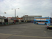
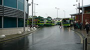
 Today, the bus station is situated in a slightly different place. The new shopping centre is built over part of where the old bus station was, and the new bus station has been constructed on the site of some old buildings and offices to the rear.
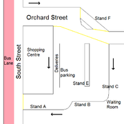
To enter the bus station, buses first turn off South Street, passing the side of the shopping centre. They are then on Orchard Street, which the bus station is situated off. As a bus approaches the bus station, stand F is on the left of it. This is on the public road beside the library. Stand F serves all former Wightbus
routes.
The main bus station is perpendicularly to the right of this. Closest to the shopping centre is a lane for delivery vehicles. Facing as though you have just turned in, left of that is the bus parking area, and to the left of that is Stand E, serving route 1 to Cowes. Beside that is a lane for through buses, and then Stand C, for routes 5, 7 and 38 (all on the right hand side of each other in the diagram). To enter any of these, the bus has to turn right off Orchard Street. All that has been described so far in this paragraph is facing in the same direction (down in diagram). In front of Stand C is the waiting room and enquiries office. In front of stand C and the bus parking area is stand B, for route 9, which is perpendicular to these stands. Route 9 buses on their stand face the exit of the bus station, in the opposite direction to the way buses enter the bus station.
Facing the same way as a route 9 bus, ahead of Stand B is Stand A, which has a large undercover waiting area rather than just shelters, due to overhanging buildings. There is space for two buses here, and other buses exiting the bus station pass on the right. In front of this is again South Street, meaning all buses come out of the bus station facing the opposite direction to which they entered. The exit of the bus station has a box junction to keep clear the bus lane from queueing traffic, and then buses have left the area.
The bus station is now considered to be too small, having been designed for less buses to use than the Go-Ahead owned Southern Vectis now runs. Buses frequently have to drop off in outside the library (in stand F or in the road), and pick up away from stands due to other buses. Buses also regularly block others from getting past.
In April 2011, following the closure of tourist information centres across the island by the Isle of Wight Council, Southern Vectis agreed to launch a new visitor information service in the main island towns. The waiting room of the bus station was refurbished to accommodate the new services.
Note: Colours represented appear on the Southern Vectis network map, but not the vehicles themselves.
Newport, Isle of Wight
Newport is a civil parish and a county town of the Isle of Wight, an island off the south coast of England. Newport has a population of 23,957 according to the 2001 census...
town centre. Recent redevelopment has seen the former 1960s-built South Street bus station demolished, to make way for a new row of shops, and the current facility built behind that site. Newport is used as the hub of Southern Vectis
Southern Vectis
The Southern Vectis Omnibus Company Limited is the dominant bus operator on the Isle of Wight. It was purchased by the Go-Ahead Group in 2005 and is a part of the company's Go South Coast division. The firm employs 299 staff, with 105 single deck, double deck and open-top buses and coaches...
's network of bus routes, so the majority of routes use Newport bus station, currently 11 out of 14. An on-site tourist info station is run by Southern Vectis giving tourist information to travellers following the cuts of the Isle of Wight Council. On 1 July 2007 the bus station became a no smoking area in its entirety, although this is frequently disregarded without any response.
Overview
There is a network of bus laneBus lane
A bus lane or bus only lane is a lane restricted to buses, and generally used to speed up public transport that would be otherwise held up by traffic congestion...
s through Newport town centre which lead to the bus station, with the aim of speeding a bus's passage into the bus station. They are located on St James' Street and South Street, and go against the direction of flow of these otherwise one-way streets. For the rebuilding of the bus station a temporary bus lane was placed along Church Litten; this was taken out of use and resurfaced to allow regular traffic to use it once the new bus station opened.
Original buildings
Competition Refused Entry
As the bus station was bought along with Southern VectisSouthern Vectis
The Southern Vectis Omnibus Company Limited is the dominant bus operator on the Isle of Wight. It was purchased by the Go-Ahead Group in 2005 and is a part of the company's Go South Coast division. The firm employs 299 staff, with 105 single deck, double deck and open-top buses and coaches...
in 1986 from the National Bus Company by Southern Vectis's management, the station is owned and maintained by Southern Vectis. This was subject to controversy from the first week of bus deregulation, as the company refused to allow any of their upstart competitors, Island Travel and Gange's Minicoaches into the station. These companies were forced to use a bus stop outside the station, obscured by parked double deckers.
Southern Vectis' refusal to allow Gange's Minicoaches to use Newport bus station prompted an investigation in 1987 by the Office of Fair Trading
Office of Fair Trading
The Office of Fair Trading is a not-for-profit and non-ministerial government department of the United Kingdom, established by the Fair Trading Act 1973, which enforces both consumer protection and competition law, acting as the UK's economic regulator...
. The first time the deregulated bus industry had come under investigation from the OFT . The OFT report, published in 1988, found Southern Vectis' behaviour to be anti-competitive, preventing smaller bus operators from establishing awareness and competing effectively. Southern Vectis was presented with an ultimatum following the report, either allow competitors to use the bus station, or face the Monopolies and Mergers Commission. The company decided that the former was preferable, and instated a programme by which competitors could use their station. At the time, Southern Vectis' relatively small competitors would have to pay an annual licence fee, insurance, and provide their timetables to Southern Vectis for the next 6 months, in return for the right to use and post timetables at appropriate stands in the station.The precedent was set, preventing privately owned bus stations from restricting access to competitors. However these terms were never agreed to by Gange's Minicoaches.
As part of the 2005 bus station redevelopment, Stand F is on the public highway, so is free for any operator to use without having to pay Southern Vectis. Whilst in operation, this facility was used by Wightbus
Wightbus
Not to be confused with Wrightbus, the bus manufacturerWightbus was a bus operator on the Isle of Wight, owned by the Isle of Wight Council...
for all its operations which used the station.
Redevelopment
Redevelopment started from the old bus station from summer 2005. During this time a temporary bus lane was set up alongside Church Litten with bus shelters erected in South Street Car Park. Buses set down in the bus lane, and stopped to pick up passengers at one of the three bus stands in Church Litten, lettered A, B or C.
The exception to this was that almost all buses from Hunnyhill used a stop in the South Street bus lane, opposite the old bus station. At the point the redevelopment work began, this meant services 2
Southern Vectis route 2
Southern Vectis route 2 is a bus service operated on the Isle of Wight by Southern Vectis between Newport and Ryde via Merstone, Godshill, Shanklin, Sandown and Brading. The general daytime frequency of the route is every half-hour each direction, although in the evenings and on Sundays fewer buses...
, 2B
Southern Vectis route 2
Southern Vectis route 2 is a bus service operated on the Isle of Wight by Southern Vectis between Newport and Ryde via Merstone, Godshill, Shanklin, Sandown and Brading. The general daytime frequency of the route is every half-hour each direction, although in the evenings and on Sundays fewer buses...
, 3
Southern Vectis route 3
Southern Vectis route 3 is a bus service operated on the Isle of Wight by Southern Vectis between Newport, Ventnor and Ryde. It also runs via Rookley, Godshill and Brading. The general daytime frequency of the route is every half-hour each direction, although in the evenings and on Sundays fewer...
, 3A
Southern Vectis route 3
Southern Vectis route 3 is a bus service operated on the Isle of Wight by Southern Vectis between Newport, Ventnor and Ryde. It also runs via Rookley, Godshill and Brading. The general daytime frequency of the route is every half-hour each direction, although in the evenings and on Sundays fewer...
and 3B
Southern Vectis route 3
Southern Vectis route 3 is a bus service operated on the Isle of Wight by Southern Vectis between Newport, Ventnor and Ryde. It also runs via Rookley, Godshill and Brading. The general daytime frequency of the route is every half-hour each direction, although in the evenings and on Sundays fewer...
towards Sandown Bay
Sandown Bay
Sandown Bay is a broad bay which stretches for much of the length of the Isle of Wight's southeastern coast. It extends ten kilometres from Culver Cliff in the northeast to just south of Shanklin in the southwest. The towns of Shanklin and Sandown are located on the bay's coast.The seabed is a...
or Ventnor
Ventnor
Ventnor is a seaside resort and civil parish established in the Victorian era on the south coast of the Isle of Wight, England. It lies underneath St Boniface Down , and is built on steep slopes and cliffs leading down to the sea...
. Services 21 and 24 also used this stop so that all buses to Sandown Bay left from the same place. After the network revision of 1 April 2006, only route 1
Southern Vectis route 1
Southern Vectis route 1 is a bus service operated by Southern Vectis between Cowes and Newport on the Isle of Wight. The daytime frequency of the route is every 7-8 minutes. There are two route variants between Northwood and Cowes Pontoon, running either via Cowes Round House or Cowes Park and Ride...
to and from Cowes used this stop, all other routes serving the stands in Church Litten. This was partly due to this route's high frequency (every 7–8 minutes at the time), and also because Newport was now the end of the route, and buses could layover
Layover
In transportation, a layover, also known as lays over or stopover, is some form of a break between parts of a single trip.-In mass transit:...
at the stand before continuing back to Cowes. Its redevelopment has been pictured. The work was completed in July 2006, when the new bus station was opened.
Modern layout
To enter the bus station, buses first turn off South Street, passing the side of the shopping centre. They are then on Orchard Street, which the bus station is situated off. As a bus approaches the bus station, stand F is on the left of it. This is on the public road beside the library. Stand F serves all former Wightbus
Wightbus
Not to be confused with Wrightbus, the bus manufacturerWightbus was a bus operator on the Isle of Wight, owned by the Isle of Wight Council...
routes.
The main bus station is perpendicularly to the right of this. Closest to the shopping centre is a lane for delivery vehicles. Facing as though you have just turned in, left of that is the bus parking area, and to the left of that is Stand E, serving route 1 to Cowes. Beside that is a lane for through buses, and then Stand C, for routes 5, 7 and 38 (all on the right hand side of each other in the diagram). To enter any of these, the bus has to turn right off Orchard Street. All that has been described so far in this paragraph is facing in the same direction (down in diagram). In front of Stand C is the waiting room and enquiries office. In front of stand C and the bus parking area is stand B, for route 9, which is perpendicular to these stands. Route 9 buses on their stand face the exit of the bus station, in the opposite direction to the way buses enter the bus station.
Facing the same way as a route 9 bus, ahead of Stand B is Stand A, which has a large undercover waiting area rather than just shelters, due to overhanging buildings. There is space for two buses here, and other buses exiting the bus station pass on the right. In front of this is again South Street, meaning all buses come out of the bus station facing the opposite direction to which they entered. The exit of the bus station has a box junction to keep clear the bus lane from queueing traffic, and then buses have left the area.
The bus station is now considered to be too small, having been designed for less buses to use than the Go-Ahead owned Southern Vectis now runs. Buses frequently have to drop off in outside the library (in stand F or in the road), and pick up away from stands due to other buses. Buses also regularly block others from getting past.
In April 2011, following the closure of tourist information centres across the island by the Isle of Wight Council, Southern Vectis agreed to launch a new visitor information service in the main island towns. The waiting room of the bus station was refurbished to accommodate the new services.
Bus routes
The following buses run from Newport Bus Station. Services are run by Southern Vectis.Southern Vectis routes
This table is correct as of the timetable revision of 5 September 2010.Note: Colours represented appear on the Southern Vectis network map, but not the vehicles themselves.
| No. | To | Via | Departure stand | Freq | Other notes | |
|---|---|---|---|---|---|---|
| 1 Southern Vectis route 1 Southern Vectis route 1 is a bus service operated by Southern Vectis between Cowes and Newport on the Isle of Wight. The daytime frequency of the route is every 7-8 minutes. There are two route variants between Northwood and Cowes Pontoon, running either via Cowes Round House or Cowes Park and Ride... |
Cowes Cowes Cowes is an English seaport town and civil parish on the Isle of Wight. Cowes is located on the west bank of the estuary of the River Medina facing the smaller town of East Cowes on the east Bank... |
St Mary's Hospital St Mary's Hospital, Isle of Wight St Mary's Hospital is a 477 bed hospital located on the outskirts of Newport on the Isle of Wight. As the only NHS hospital on the Island, all NHS services are provided or commissioned from there... , Northwood Northwood, Isle of Wight Northwood is a village and civil parish on the Isle of Wight. It lies south of the town of Cowes and has been occupied for about 1000 years. The Church of St. John the Baptist in Northwood, was first built between the 11th and 13th centuries.... , Round House or Park and Ride Cowes park and ride Cowes park and ride is a park and ride scheme on the Isle of Wight, featuring a 85-space car park and bus stop on the outskirts of Cowes in Somerton, on a former industrial site. It is currently served by Southern Vectis buses on route 1 every 12 minutes during the day. From the Park and Ride, a... |
Stand E | 7-8 | Enters bus station from bus lanes on St James' Street and South Street. | |
| 2 Southern Vectis route 2 Southern Vectis route 2 is a bus service operated on the Isle of Wight by Southern Vectis between Newport and Ryde via Merstone, Godshill, Shanklin, Sandown and Brading. The general daytime frequency of the route is every half-hour each direction, although in the evenings and on Sundays fewer buses... |
Sandown Sandown Sandown is a seaside resort town and civil parish on the southeast coast of the Isle of Wight, England, neighbouring the town of Shanklin to the south. Sandown Bay is the name of the bay off the English Channel which both towns share, and it is notable for its long stretch of easily accessible... |
Rookley Rookley Rookley is a village and civil parish on the Isle of Wight. It is located five kilometres south of Newport near the centre of the Island.It has a country park on the site of the last working Isle of Wight brickworks. There is a pub at the country park and another pub, the "Chequers" a short... , Godshill Godshill Godshill is a village and civil parish on the Isle of Wight with a population of 1,465 according to the 2001 census. It is located between Newport and Ventnor in the southeast of the Island.-History:... , Shanklin Shanklin Shanklin is a popular seaside resort and civil parish on the Isle of Wight, England, located on the east coast's Sandown Bay. The sandy beach, its Old Village and a wooded ravine, Shanklin Chine, are its main attractions. The esplanade along the beach is occupied by hotels and restaurants for the... |
Stand A | 30 | Enters bus station from Medina Avenue. | |
| 3 Southern Vectis route 3 Southern Vectis route 3 is a bus service operated on the Isle of Wight by Southern Vectis between Newport, Ventnor and Ryde. It also runs via Rookley, Godshill and Brading. The general daytime frequency of the route is every half-hour each direction, although in the evenings and on Sundays fewer... |
Ryde Ryde Ryde is a British seaside town, civil parish and the most populous town and urban area on the Isle of Wight, with a population of approximately 30,000. It is situated on the north-east coast. The town grew in size as a seaside resort following the joining of the villages of Upper Ryde and Lower... |
Merstone Merstone, Isle of Wight Merstone is a quaint little hamlet on the Isle of Wight. It is home to Merston Manor, built in 1605 in the Jacobean style by Edward Cheeke, and rebuilt in the Victorian era. Merston Manor was first mentioned in the Domesday Book, and the present structure is arguably the oldest brick house on the... , Godshill Godshill Godshill is a village and civil parish on the Isle of Wight with a population of 1,465 according to the 2001 census. It is located between Newport and Ventnor in the southeast of the Island.-History:... , Wroxall Wroxall, Isle of Wight Wroxall is a village and civil parish in the central south of the Isle of Wight.It is close to Appuldurcombe House. The parish church is St. John's Church, Wroxall.... , Ventnor Ventnor Ventnor is a seaside resort and civil parish established in the Victorian era on the south coast of the Isle of Wight, England. It lies underneath St Boniface Down , and is built on steep slopes and cliffs leading down to the sea... , Shanklin Shanklin Shanklin is a popular seaside resort and civil parish on the Isle of Wight, England, located on the east coast's Sandown Bay. The sandy beach, its Old Village and a wooded ravine, Shanklin Chine, are its main attractions. The esplanade along the beach is occupied by hotels and restaurants for the... , Sandown Sandown Sandown is a seaside resort town and civil parish on the southeast coast of the Isle of Wight, England, neighbouring the town of Shanklin to the south. Sandown Bay is the name of the bay off the English Channel which both towns share, and it is notable for its long stretch of easily accessible... , Brading Brading The ancient 'Kynges Towne' of Brading is the main town of the civil parish of the same name. The ecclesiastical parish of Brading used to cover about a tenth of the Isle of Wight. The current civil parish now includes the town itself and Adgestone, Morton, Nunwell and other outlying areas between... , Tesco |
Stand A | 30 | Enters bus station from Medina Avenue. | |
| 5 Southern Vectis route 5 Southern Vectis route 5 is a bus service operated on the Isle of Wight by Southern Vectis between Newport and East Cowes via Fairlee, Whippingham and Osborne House. The general daytime frequency of the route is every 15 minutes in each direction, reducing to half-hourly for evenings and... |
East Cowes Cowes Cowes is an English seaport town and civil parish on the Isle of Wight. Cowes is located on the west bank of the estuary of the River Medina facing the smaller town of East Cowes on the east Bank... |
Fairlee Fairlee, Isle of Wight Fairlee is a suburb of Newport, on the Isle of Wight, on the east side of the River Medina. Fairlee Road runs through the area. During a week in June each year the main road northbound is completely closed to vehicles during the Isle of Wight Festival. Fairlee Service Station, Seaclose Stores and... , Whippingham Whippingham Whippingham is a village and civil parish on the Isle of Wight. It is located two kilometres south of East Cowes in the north of the Island.Whippingham is best known for its connections with Queen Victoria, especially its church, redesigned by Prince Albert. The church has a tower reminiscent of a... , Osborne House Osborne House Osborne House is a former royal residence in East Cowes, Isle of Wight, UK. The house was built between 1845 and 1851 for Queen Victoria and Prince Albert as a summer home and rural retreat.... |
Stand C | 15 | Enters bus station from Coppins Bridge, then South Street. | |
| 6 Southern Vectis route 6 Southern Vectis route 6 is a bus service operated on the Isle of Wight by Southern Vectis between Newport, Blackgang and Ventnor. It also runs via Carisbrooke, Chillerton, Chale Green, Chale, Niton, St Lawrence and Whitwell. Five journeys are made in each direction Monday to Saturday, with four on... |
Ventnor Ventnor Ventnor is a seaside resort and civil parish established in the Victorian era on the south coast of the Isle of Wight, England. It lies underneath St Boniface Down , and is built on steep slopes and cliffs leading down to the sea... |
Chillerton Chillerton, Isle of Wight Chillerton is a village between Newport and Chale on the Isle of Wight in southern England. Chillerton is in the middle of a farming community.... , Chale Chale, Isle of Wight Chale is a village and civil parish on the Isle of Wight, England. It is located three kilometres from Niton in the south of the island in the area known as the Back of the Wight . The village of Chale lies at the foot of St. Catherine's Down.-History:... , Blackgang Chine Blackgang Chine Blackgang Chine is the location of a now-destroyed chine in the soft Cretaceous cliffs about 6 miles from Ventnor at the southern tip of the Isle of Wight just below St Catherine's Down. Since 1843 it has been home to the Blackgang Chine amusement park, run by the Dabell family who also run the... , Niton Niton, Isle of Wight Niton is a village on the Isle of Wight, near Ventnor with a thriving population of 1142, supporting two pubs, several churches,a pottery workshop/shop, a pharmacy and 3 local shops including a post office... , Whitwell Whitwell, Isle of Wight Whitwell is located in the south of the Isle of Wight, slightly to the south of Godshill, and extends to the southern shore of the island. The nearest town is Ventnor, about 5 kilometres South of the village. Niton is the nearest village about away, which together, Whitwell and Niton form a civil... |
Stand A | 60 | Enters bus station from Medina Avenue. | |
| 7 Southern Vectis route 7 Southern Vectis route 7 is a bus service operated by Southern Vectis between Newport and Alum Bay via Yarmouth, Freshwater and Totland. The general daytime frequency of the route is every hour each direction. There has been significant local concern over the withdrawal of route 7 from some villages... |
Alum Bay Alum Bay Alum Bay is a bay near the westernmost point of the Isle of Wight, England, within sight of the Needles. Of geological interest and a tourist attraction, the bay is noted for its multi-coloured sand cliffs.-Geology:... |
Carisbrooke Carisbrooke Carisbrooke is a village on the south western outskirts of Newport, Isle of Wight. It is best known as the site of Carisbrooke Castle. It also has a medieval parish church. St. Mary's Church , began life as part of a Benedictine priory, established by French monks about 1150... ; Shalfleet Shalfleet Shalfleet is a village and civil parish on the Isle of Wight. it is located between Yarmouth and Newport in the northwest of the island.-Background:... , Wellow Wellow, Isle of Wight Wellow is a village on the Isle of Wight. It is located about two miles east of Yarmouth in the northwest of the island. The name is believed to be of Jutish origin. Recently a proposal to erect a wind farm was rejected after a high profile protest campaign. Located within Wellow are a small... , Thorley Thorley Thorley could be*Thorley, Isle of Wight*Thorley, HertfordshirePeople:* Dianne Thorley, Australian politician* Wilfrid Thorley, English poet... , Yarmouth Yarmouth, Isle of Wight Yarmouth is a port and civil parish in the western part of the Isle of Wight, off the southern coast of mainland England. The town is named for its location at the mouth of the small Western Yar river... , Freshwater Freshwater, Isle of Wight Freshwater is a large village and civil parish at the western end of the Isle of Wight, England. Freshwater Bay is a small cove on the south coast of the Island which also gives its name to the nearby part of Freshwater.... , Totland Totland Totland is a village and civil parish at the western tip of the Isle of Wight. It lies on the coast at Colwell Bay, which is the closest part of the island to the British mainland... |
Stand C | 60 | ||
| 8 Southern Vectis route 8 Southern Vectis route 8 is a bus service operated on the Isle of Wight by Southern Vectis between Newport and Ryde. The route travels via Pan Estate, Robin Hill, Arreton, Winford, Lake, Sandown, Yaverland, Bembridge, St Helens, Nettlestone, Seaview and Pondwell. The general daytime frequency of the... |
Ryde Ryde Ryde is a British seaside town, civil parish and the most populous town and urban area on the Isle of Wight, with a population of approximately 30,000. It is situated on the north-east coast. The town grew in size as a seaside resort following the joining of the villages of Upper Ryde and Lower... |
Pan Estate, Robin Hill, Arreton Arreton Arreton is a village and civil parish in the central eastern part of the Isle of Wight, England. It is about 3 miles south east of Newport.-Name:The settlement has had different names and different spellings over the years... , Winford Winford, Isle of Wight Winford is a hamlet on the Isle of Wight, that since the 1950s and in particular in the late 1970s has seen considerable housing development. The local shop in Forest Road closed some time ago, but tourist attractions with gift shops are situated nearby.... , Lake Lake, Isle of Wight Lake is a village and civil parish located on Sandown Bay, on the Isle of Wight, England.Lake is named after the Old English "Lacu" referring to the creek that ran along what is now Scotchells Brook, which is between the Isle of Wight Airport and the Morrisons Superstore and the Spithead Industrial... , Sandown Sandown Sandown is a seaside resort town and civil parish on the southeast coast of the Isle of Wight, England, neighbouring the town of Shanklin to the south. Sandown Bay is the name of the bay off the English Channel which both towns share, and it is notable for its long stretch of easily accessible... , Yaverland Yaverland Yaverland is a village on the Isle of Wight, just north of Sandown. It has about 200 houses. About 1/3 of a mile away from the village is the Yaverland Manor and Church. Holotype fossils have been discovered here of Yaverlandia and a pterosaur, Caulkicephalus... , Bembridge Bembridge Bembridge is an affluent village and civil parish located on the easternmost point of the Isle of Wight. It had a population of 3,848 according to the 2001 census of the United Kingdom, leading to claims by residents that Bembridge is the largest village in England, and occasional claims that it is... , St Helens St Helens, Isle of Wight St. Helens is a village and civil parish located on the eastern side of the Isle of Wight. The village is based around village greens. This is claimed to be the largest in England but some say the Village Green is the second largest. The greens are often used for cricket matches during the summer... , Seaview Seaview, Isle of Wight Seaview is a small Edwardian resort located on the north-eastern corner of the Isle of Wight, overlooking the Solent.The village is popular with tourists and is only a 15-minute drive from the town of Ryde, where most tourists reach the island by ferry or hovercraft... , Nettlestone Nettlestone Nettlestone is a village on the Isle of Wight, England about 4 miles south east of Ryde. It is listed in the Domesday Book and was established c.1086... |
Stand A | 30 | Enters bus station from Coppins Bridge Roundabout, then South Street. | |
| 9 Southern Vectis route 9 Southern Vectis route 9 is a bus route operated on the Isle of Wight by Southern Vectis between Newport and Ryde via Fairlee/Staplers, Wootton and Binstead. The general daytime frequency of the route is every 10 minutes in each direction, every 15 minutes on Sundays and every 15 minutes in the... |
Ryde Ryde Ryde is a British seaside town, civil parish and the most populous town and urban area on the Isle of Wight, with a population of approximately 30,000. It is situated on the north-east coast. The town grew in size as a seaside resort following the joining of the villages of Upper Ryde and Lower... |
Fairlee Fairlee, Isle of Wight Fairlee is a suburb of Newport, on the Isle of Wight, on the east side of the River Medina. Fairlee Road runs through the area. During a week in June each year the main road northbound is completely closed to vehicles during the Isle of Wight Festival. Fairlee Service Station, Seaclose Stores and... or Staplers Staplers Staplers is a suburb of Newport, Isle of Wight, England, on the east side of the River Medina.It houses the Crown Offices which discharge the principal functions of national government on the Isle of Wight such as the Department for Work and Pensions... , Wootton, Binstead Binstead Binstead is a village on the Isle of Wight. It is located in the northeast of the Island, two kilometres west of Ryde on the main road between Ryde and Newport.-Amenities:... |
Stand B | 10 | Enters bus station from Coppins Bridge Roundabout, then South Street. | |
| 12 Southern Vectis route 12 Southern Vectis route 12 is a bus service operated by Southern Vectis between Newport and Totland via Shorwell, Brighstone and Freshwater.- West Wight Route :... |
Totland Totland Totland is a village and civil parish at the western tip of the Isle of Wight. It lies on the coast at Colwell Bay, which is the closest part of the island to the British mainland... |
Carisbrooke Carisbrooke Carisbrooke is a village on the south western outskirts of Newport, Isle of Wight. It is best known as the site of Carisbrooke Castle. It also has a medieval parish church. St. Mary's Church , began life as part of a Benedictine priory, established by French monks about 1150... , Brighstone Brighstone Brighstone is a village and civil parish on the Isle of Wight, 6 miles southwest of Newport on the B3399 road. Brighstone was previously known as "Brixton"... , Freshwater Freshwater, Isle of Wight Freshwater is a large village and civil parish at the western end of the Isle of Wight, England. Freshwater Bay is a small cove on the south coast of the Island which also gives its name to the nearby part of Freshwater.... |
Stand F | 120-180 | ||
| 25 Southern Vectis route 25 Southern Vectis route 25 is a bus service operated on the Isle of Wight by Southern Vectis between Newport and East Cowes via Fairlee, Folly Inn and Whippingham & Hefford Road. The general daytime frequency of the route is 6 Journeys Each Day... |
East Cowes East Cowes East Cowes is a town and civil parish to the north of the Isle of Wight, on the east bank of the River Medina next to its neighbour on the west bank, Cowes.... |
Folly Inn, Whippingham Whippingham Whippingham is a village and civil parish on the Isle of Wight. It is located two kilometres south of East Cowes in the north of the Island.Whippingham is best known for its connections with Queen Victoria, especially its church, redesigned by Prince Albert. The church has a tower reminiscent of a... , Hefford Road |
Stand F | 60-75 | Only three journeys a day run from Newport. | |
| 38 | Newport | Gunville Gunville Gunville is a settlement on the Isle of Wight, off the south coast of England.The village lies south of the A3054 road, near to the larger settlement of Carisbrooke. Gunville is approximately west of Newport. The name comes from Victorian times when the area was used to store ammunition, and the... , Carisbrooke Carisbrooke Carisbrooke is a village on the south western outskirts of Newport, Isle of Wight. It is best known as the site of Carisbrooke Castle. It also has a medieval parish church. St. Mary's Church , began life as part of a Benedictine priory, established by French monks about 1150... |
Stand C | 30 | Circular service in above direction only, and enters back into the bus station from Medina Avenue. | |
| X10 | Whitecliff Bay Whitecliff Bay Whitecliff Bay is a sandy bay near the easternmost point of the Isle of Wight, England about 2 miles south-west of Bembridge and just to the north of Culver Down. It is a tourist site , has a popular beach with two hundred metres of sand and shingle, and minimal facilities including 2 cafes... |
Brading Brading The ancient 'Kynges Towne' of Brading is the main town of the civil parish of the same name. The ecclesiastical parish of Brading used to cover about a tenth of the Isle of Wight. The current civil parish now includes the town itself and Adgestone, Morton, Nunwell and other outlying areas between... , St Helens St Helens, Isle of Wight St. Helens is a village and civil parish located on the eastern side of the Isle of Wight. The village is based around village greens. This is claimed to be the largest in England but some say the Village Green is the second largest. The greens are often used for cricket matches during the summer... , Bembridge Bembridge Bembridge is an affluent village and civil parish located on the easternmost point of the Isle of Wight. It had a population of 3,848 according to the 2001 census of the United Kingdom, leading to claims by residents that Bembridge is the largest village in England, and occasional claims that it is... |
Stand A | N/A | Commuter service. 1 journey into Newport am, 1 return pm. Also stops at Robin Hill and Broadlands House on request. | |
| X11 | Totland Totland Totland is a village and civil parish at the western tip of the Isle of Wight. It lies on the coast at Colwell Bay, which is the closest part of the island to the British mainland... |
Freshwater Freshwater, Isle of Wight Freshwater is a large village and civil parish at the western end of the Isle of Wight, England. Freshwater Bay is a small cove on the south coast of the Island which also gives its name to the nearby part of Freshwater.... |
Stand C | N/A | Commuter service. 1 journey into Newport am, 1 return pm. | |
| 23 | Shanklin Shanklin Shanklin is a popular seaside resort and civil parish on the Isle of Wight, England, located on the east coast's Sandown Bay. The sandy beach, its Old Village and a wooded ravine, Shanklin Chine, are its main attractions. The esplanade along the beach is occupied by hotels and restaurants for the... |
Newchurch Newchurch, Isle of Wight Newchurch is a village and civil parish on the Isle of Wight. It is located between Sandown and Newport in the southeast of the island. Anthony Dillington, owner of the Knighton Gorges Manor in Newchurch wrote to his son Robert in 1574 that, "This is the very Garden of England, and we be privileged... , Winford Winford, Isle of Wight Winford is a hamlet on the Isle of Wight, that since the 1950s and in particular in the late 1970s has seen considerable housing development. The local shop in Forest Road closed some time ago, but tourist attractions with gift shops are situated nearby.... , Alverstone Alverstone Alverstone is a village 3 kilometres from the east coast of the Isle of Wight, near Sandown. When Richard Webster became Chief Justice of England in 1900, he chose the title Lord Alverstone because it was the title he was permitted to choose which was "closest" to Sandown, one of his favourite... |
60 off peak | Only 3 journeys each day run to Newport | ||
| 33 | Ryde Ryde Ryde is a British seaside town, civil parish and the most populous town and urban area on the Isle of Wight, with a population of approximately 30,000. It is situated on the north-east coast. The town grew in size as a seaside resort following the joining of the villages of Upper Ryde and Lower... |
Robin Hill, Havenstreet Havenstreet Havenstreet is a village on the Isle of Wight, located about 2 miles southwest of Ryde.The Isle of Wight Steam Railway Museum is in Havenstreet, along with a station. Every year, the Isle of Wight Steam Railway runs a "Santa Express" train from Wootton to Havenstreet, which is a centre of... |
Limited service | Run within a community partnership between Southern Vectis and Isle of Wight Council. | ||
| 35 | Newtown Newtown, Isle of Wight Newtown is a small hamlet on the Isle of Wight, in England. In medieval times it was a thriving borough.Newtown is located on the large natural harbour on the Island's north-western coast, now mostly a National Nature Reserve owned and managed by the National Trust.The Caul Bourne stream running... |
Marks Corner, Thorness Bay Thorness Bay Thorness Bay is a 86.2 hectare Site of special scientific interest which is located on the north-west coast of the Isle of Wight, England, in the western arm of the Solent... , Porchfield Porchfield Porchfield is a village on the Isle of Wight between Cowes and Yarmouth. It is located seven kilometres southwest of Cowes in the northwest of the island.... |
Limited service | Run within a community partnership between Southern Vectis and Isle of Wight Council. | ||
| 36 | Brighstone Brighstone Brighstone is a village and civil parish on the Isle of Wight, 6 miles southwest of Newport on the B3399 road. Brighstone was previously known as "Brixton"... |
Chillerton, Yafford Yafford Yafford is a hamlet on the Isle of Wight . It is located nine kilometres from Newport in the southwest of the island an area known as the Back of the Wight between Brighstone and Niton. It has a non operational water mill, which was working until 1970. The mill has an overshot water wheel, powered... , Moortown Moortown, Isle of Wight Moortown is a part of Brighstone on the west side of the island. The area is known as the Back of the Wight. The only form of public transport to pass through the village is infrequent Wightbus service 36, connecting the village with Newport and Brighstone.... |
Limited service | Run within a community partnership between Southern Vectis and Isle of Wight Council. | ||
| 39 | Newport Newport, Isle of Wight Newport is a civil parish and a county town of the Isle of Wight, an island off the south coast of England. Newport has a population of 23,957 according to the 2001 census... |
Pan Estate | 30 off peak | Circular service. Run within a community partnership between Southern Vectis and Isle of Wight Council. |