

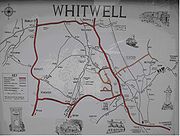
Whitwell, Isle of Wight
Encyclopedia
Godshill
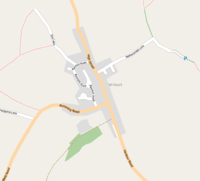
Godshill is a village and civil parish on the Isle of Wight with a population of 1,465 according to the 2001 census. It is located between Newport and Ventnor in the southeast of the Island.-History:...
, and extends to the southern shore of the island. The nearest town is Ventnor, about 5 kilometres South of the village. Niton is the nearest village about 2 miles (3.2 km) away, which together, Whitwell and Niton form a civil parish. Also close to the village, is Nettlecombe, the site of a lost medieval village located slightly to the north east.
The Isle of Wight Medieval Landscape Project | publisher = www.wac.soton.ac.uk | accessdate = 2007-06-06}} The entire village is surrounded mainly by fields and classed as an 'Area of Outstanding Natural Beauty
Area of Outstanding Natural Beauty
An Area of Outstanding Natural Beauty is an area of countryside considered to have significant landscape value in England, Wales or Northern Ireland, that has been specially designated by the Countryside Agency on behalf of the United Kingdom government; the Countryside Council for Wales on...
, forming part of the Isle of Wight AONB
Isle of Wight AONB
The Isle of Wight Area of Outstanding Natural Beauty is an Area of Outstanding Natural Beauty on the Isle of Wight, England's largest offshore island....
.' The relief is mainly flat, with some slight hills. It contains 1910 acres (7.7 km²) of land, 687 acres (2.8 km²) in 1905 being arable land, 775½ acres permanent grass, and 74½ acres woodland.
British Isles
The British Isles are a group of islands off the northwest coast of continental Europe that include the islands of Great Britain and Ireland and over six thousand smaller isles. There are two sovereign states located on the islands: the United Kingdom of Great Britain and Northern Ireland and...
, and fewer frosts.
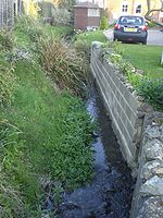
The Eastern Yar
Eastern Yar
The River Yar on the Isle of Wight, England, rises in a chalk coomb in St. Catherine's Down near Niton, close to the southern point of the island...
, originating in the north-east of the island, extends an infant tributary to Whitwell and at one point, a stone sheep wash is still present. The River Yar Trail was set up on 24 May 2002, with a milestone outside the White Horse in Whitwell.
Whitwell's built environment
Built environment
The term built environment refers to the human-made surroundings that provide the setting for human activity, ranging in scale from personal shelter and buildings to neighborhoods and cities that can often include their supporting infrastructure, such as water supply or energy networks.The built...
is characterised by its mixture of stone and thatched housing. There is a mixture of single and two-story houses, with most single-story housing on Bannock Road, recently developed with a small estate of bungalows. Terraced housing features in the center of the village. The most notable house in the village is The Old Rectory, close to the church and was formerly a Bed and Breakfast
Bed and breakfast
A bed and breakfast is a small lodging establishment that offers overnight accommodation and breakfast, but usually does not offer other meals. Since the 1980s, the meaning of the term has also extended to include accommodations that are also known as "self-catering" establishments...
.
Church
The Church of St. Mary and St. Radegund is a Church of EnglandChurch of England
The Church of England is the officially established Christian church in England and the Mother Church of the worldwide Anglican Communion. The church considers itself within the tradition of Western Christianity and dates its formal establishment principally to the mission to England by St...
church, located on rising ground at the south end of the village, adjoining the rectory. It is the only church in the village. Parts of the church date back to different centuries, the earliest being 12th, with later parts added in the 13th, 15th and 16th century. In April 2007, the village's post office was relocated inside the church's bell tower, the first of its kind to actually be located inside the church.
Amenities
The village used to have a wide range of facilities used by local residents. However over the years, many of these have gone. These include two shops, a playgroup, its Methodist church, the forge, a nursing home and youth hostel. The facilities left include: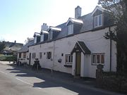
- Post OfficePost officeA post office is a facility forming part of a postal system for the posting, receipt, sorting, handling, transmission or delivery of mail.Post offices offer mail-related services such as post office boxes, postage and packaging supplies...
- The village used to have its own, family owned post office. This was closed in 2006, however later in 2007 was relocated onto a new premises inside the church. - Pub - The White Horse in the village centre is a popular pub across the island. It suffered a fire in 1987, then again 20 years later in 2007 which saw its temporary closure. Prior to the two fires, the pub was thatched, however after the fire in 2007, a tiled roof was built, in an attempt to prevent future fires.
- GarageFilling stationA filling station, also known as a fueling station, garage, gasbar , gas station , petrol bunk , petrol pump , petrol garage, petrol kiosk , petrol station "'servo"' in Australia or service station, is a facility which sells fuel and lubricants...
- The village's garage, named Whitwell garage is one of the only garages left on the island to still sell petrol (excluding supermarkets). It also sells cars, MOTs and servicing, specializing in Ford. - Village hallVillage hallIn the United States, a village hall is the seat of government for villages. It functions much as a city hall does within cities.In the United Kingdom, a village hall is usually a building within a village which contains at least one large room, usually owned by and run for the benefit of the local...
- It is used to host a variety of activities, as well as the Whitwell Village Show, which takes place annually each summer.
Due to the village's small size and small population of 578, most amenities are located outside the village. Many are located in the slightly larger neighbouring village of Niton, such as a Pharmacy and doctor's surgery. Others are located in the nearby town of Ventnor.
Transport
Rail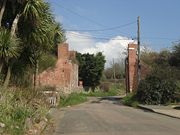
Whitwell (Isle of Wight) railway station
Whitwell Station, on the Ventnor West branch of the Isle of Wight Central Railway, was opened on 26 July 1897 along with the other stations on the branch...
, on the Ventnor West branch of the Isle of Wight Central Railway, was opened along with the other stations on the branch on 20 July 1897. It was equipped with a passing loop, two platforms, a signal box and a substantial station building. Located at the top of Nettlecombe Lane, the station is located close to the village and the community it was intended to serve, unlike any other stations on the line.
However the track has now closed, and the waiting rooms have now been converted into two cottages and the old up platform has been restored. The site is now a popular tourist destination and is used for holiday accommodation. An old railway tunnel just outside the village is used as a mushroom farm. Another tunnel is still present on Nettlecombe Lane (pictured to the left) leading to the station.
Bus
Southern Vectis
Southern Vectis
The Southern Vectis Omnibus Company Limited is the dominant bus operator on the Isle of Wight. It was purchased by the Go-Ahead Group in 2005 and is a part of the company's Go South Coast division. The firm employs 299 staff, with 105 single deck, double deck and open-top buses and coaches...
bus route 6
Southern Vectis route 6
Southern Vectis route 6 is a bus service operated on the Isle of Wight by Southern Vectis between Newport, Blackgang and Ventnor. It also runs via Carisbrooke, Chillerton, Chale Green, Chale, Niton, St Lawrence and Whitwell. Five journeys are made in each direction Monday to Saturday, with four on...
links the village with the towns of Newport
Newport, Isle of Wight
Newport is a civil parish and a county town of the Isle of Wight, an island off the south coast of England. Newport has a population of 23,957 according to the 2001 census...
and Ventnor
Ventnor
Ventnor is a seaside resort and civil parish established in the Victorian era on the south coast of the Isle of Wight, England. It lies underneath St Boniface Down , and is built on steep slopes and cliffs leading down to the sea...
, including intermediate villages. The last bus from Newport is early at 18:22 providing no evening service for the village. The seasonal 'Island Coaster' also runs through the village during the summer. Wightbus
Wightbus
Not to be confused with Wrightbus, the bus manufacturerWightbus was a bus operator on the Isle of Wight, owned by the Isle of Wight Council...
and Southern Vectis take students to school, which has caused some controversy over two bus companies taking a small number of students to school.
Roads
The main road leading to Ventnor has recently been widened and resurfaced to cope with the larger number of cars using it, however this has caused controversy with nearby residents with reports of many cars speeding through the village. A sign was later put up, warning motorists if their speed exceeded the 30 mile per hour speed limit. More were later put up across other parts of the village.
Walking
The River Yar trail runs through the village with the milestone outside the village Pub. In addition to this, briddleways are maintained, running to nearby villages Wroxall and Niton. Future plans could see a pedestrian link from Whitwell to Niton along the main road.