
Blue Ridge Road
Encyclopedia
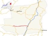
Blue Ridge Road is a 19.2 miles (30.9 km) long roadway in Essex County, New York
, in the United States
. The road is designated as County Route 84 (CR 84) from NY 28N
in Newcomb
to Interstate 87 (I-87) in North Hudson
, and as New York State Route 910K (NY 910K) between I-87 and U.S. Route 9 (US 9) in North Hudson. The CR 84 portion is an 18 miles (29 km), two-lane stretch of rural highway maintained by the Essex County Department of Public Works' Highway Division while NY 910K is a 1 miles (1.6 km) highway maintained by the New York State Department of Transportation
(NYSDOT). All of Blue Ridge Road has been designated as the "Blue Ridge Road Scenic Byway" by NYSDOT.
Blue Ridge Road was designated as part of NY 73
in the 1930 renumbering of state routes in New York. NY 73 was truncated to Schroon
in the mid-1930s.
's CR 84, which composes the bulk of the route, and NY 910K, which is a short, state-maintained roadway connecting I-87 to US 9. The entirety of Blue Ridge Road is designated as the "Blue Ridge Road Scenic Byway", a New York State Scenic Byway, by the New York State Department of Transportation
.
and CR 75 (Eaton Lane) in the area south of Tahawus . The road heads to the northeast, initially paralleling the Hudson River
, then intersects with CR 25 (Tahawus Road), which heads north to the hamlet of Tahawus. After that, the route diverges from the Hudson River, turning to the southeast and climbing slightly to the side of Pine Hill, before progressing downhill. At the base of the mountain, CR 84 crosses over Vanderwhacker Brook, which flows into nearby Vanderwhacker Pond. The road winds its way around several different mountain peaks, passing to the north of Cheney Pond.
After passing through the hamlet of Boreas River, CR 84 briefly follows Wolf Pond Brook, which eventually turns north for nearby Wolf Pond. The road continues eastward past Sand Pond and begins to descend, roughly following Sand Pond Brook. It passes along the base of Ragged Mountain, a high peak in the Adirondacks, after which the road runs along the edge of the valley of the stream known as "The Branch." At the base of Three Brothers Mountain, CR 84 curves northeast before making a turn to the southeast, soon entering the hamlet of Blue Ridge.
With The Branch still paralleling to the south, CR 84 continues its eastward descent and eventually intersects with its first road in several miles, Lazy Street, which provides access to the creek. At the base of Nippletop Mountain, Blue Ridge Road passes along the north shore of Palmer Pond, a small pond visible from the Adirondack Northway (I-87
). Soon after, Blue Ridge Road intersects with the ramps leading to and from the Northway and the county-maintained portion of Blue Ridge Road ends.
as NY 910K. The route heads eastward from the Northway ramps to nearby US 9. On this 0.72 miles (1.16 km) stretch, there is one intermediate intersection, this being with an unnamed roadway. The route ends at US 9 in the hamlet of North Hudson
.
in the 1930 renumbering of state highways in New York. NY 73 initially ran from NY 28N
east to an intersection with US 9 in North Hudson
, where NY 73 turned south to follow US 9 toward Schroon
. The route was truncated ca. 1936 to begin at US 9 in Schroon. NY 73's former alignment along Blue Ridge Road was redesignated as County Route 2B by 1969. The section between the Northway and US 9 was later transferred to the state and assigned the NY 910K designation. On May 21, 2009, New York Governor David Paterson
announced that stimulus money from the American Recovery and Reinvestment Act would be used to reconstruct the CR 84 segment of the Blue Ridge Road, seeing it as a major connector from NY 28N to I-87.
Essex County, New York
Essex County is a county located in the U.S. state of New York. As of the 2010 census, the population was 39,370. Its name is from the English county of Essex. Its county seat is Elizabethtown...
, in the United States
United States
The United States of America is a federal constitutional republic comprising fifty states and a federal district...
. The road is designated as County Route 84 (CR 84) from NY 28N
New York State Route 28N
New York State Route 28N is a state highway in the Adirondacks in New York that extends from Blue Mountain Lake to North Creek. The route, in length, is a northerly alternate route to NY 28 between both locations. The highway passes through several communities before terminating at...
in Newcomb
Newcomb, New York
Newcomb is a town in Essex County, New York, United States. The population was 481 at the 2000 census.The Town of Newcomb is at the west border of the county. It is southwest of Plattsburgh, southwest of Burlington, VT, northeast of Utica, NY, north-northeast of Albany, NY, and ...
to Interstate 87 (I-87) in North Hudson
North Hudson, New York
North Hudson is a town in Essex County, New York, United States. The population was 266 at the 2000 census. The town derives its name by being by the north end of the Hudson River....
, and as New York State Route 910K (NY 910K) between I-87 and U.S. Route 9 (US 9) in North Hudson. The CR 84 portion is an 18 miles (29 km), two-lane stretch of rural highway maintained by the Essex County Department of Public Works' Highway Division while NY 910K is a 1 miles (1.6 km) highway maintained by the New York State Department of Transportation
New York State Department of Transportation
The New York State Department of Transportation is responsible for the development and operation of highways, railroads, mass transit systems, ports, waterways and aviation facilities in the U.S...
(NYSDOT). All of Blue Ridge Road has been designated as the "Blue Ridge Road Scenic Byway" by NYSDOT.
Blue Ridge Road was designated as part of NY 73
New York State Route 73
New York State Route 73 is a state highway located entirely within Essex County, New York, United States. The highway begins at an intersection with NY 86 in the village of Lake Placid and ends at a junction with U.S. Route 9 north of the hamlet of Underwood in the extreme...
in the 1930 renumbering of state routes in New York. NY 73 was truncated to Schroon
Schroon, New York
Schroon is a town in the Adirondack Park, in Essex County, New York, United States. The population was 1,759 at the 2000 census. The town is also known as Schroon Lake, which is actually a centrally located lake, and the name of a hamlet on the lake....
in the mid-1930s.
Route description
Blue Ridge Road consists of Essex CountyEssex County, New York
Essex County is a county located in the U.S. state of New York. As of the 2010 census, the population was 39,370. Its name is from the English county of Essex. Its county seat is Elizabethtown...
's CR 84, which composes the bulk of the route, and NY 910K, which is a short, state-maintained roadway connecting I-87 to US 9. The entirety of Blue Ridge Road is designated as the "Blue Ridge Road Scenic Byway", a New York State Scenic Byway, by the New York State Department of Transportation
New York State Department of Transportation
The New York State Department of Transportation is responsible for the development and operation of highways, railroads, mass transit systems, ports, waterways and aviation facilities in the U.S...
.
County Route 84
Blue Ridge Road begins at an intersection with NY 28NNew York State Route 28N
New York State Route 28N is a state highway in the Adirondacks in New York that extends from Blue Mountain Lake to North Creek. The route, in length, is a northerly alternate route to NY 28 between both locations. The highway passes through several communities before terminating at...
and CR 75 (Eaton Lane) in the area south of Tahawus . The road heads to the northeast, initially paralleling the Hudson River
Hudson River
The Hudson is a river that flows from north to south through eastern New York. The highest official source is at Lake Tear of the Clouds, on the slopes of Mount Marcy in the Adirondack Mountains. The river itself officially begins in Henderson Lake in Newcomb, New York...
, then intersects with CR 25 (Tahawus Road), which heads north to the hamlet of Tahawus. After that, the route diverges from the Hudson River, turning to the southeast and climbing slightly to the side of Pine Hill, before progressing downhill. At the base of the mountain, CR 84 crosses over Vanderwhacker Brook, which flows into nearby Vanderwhacker Pond. The road winds its way around several different mountain peaks, passing to the north of Cheney Pond.
After passing through the hamlet of Boreas River, CR 84 briefly follows Wolf Pond Brook, which eventually turns north for nearby Wolf Pond. The road continues eastward past Sand Pond and begins to descend, roughly following Sand Pond Brook. It passes along the base of Ragged Mountain, a high peak in the Adirondacks, after which the road runs along the edge of the valley of the stream known as "The Branch." At the base of Three Brothers Mountain, CR 84 curves northeast before making a turn to the southeast, soon entering the hamlet of Blue Ridge.
With The Branch still paralleling to the south, CR 84 continues its eastward descent and eventually intersects with its first road in several miles, Lazy Street, which provides access to the creek. At the base of Nippletop Mountain, Blue Ridge Road passes along the north shore of Palmer Pond, a small pond visible from the Adirondack Northway (I-87
Interstate 87
Interstate 87 is a Interstate Highway located entirely within New York State in the United States of America. I-87 is the longest intrastate Interstate highway in the Interstate Highway System. Its southern end is at the Bronx approaches of the Robert F. Kennedy Bridge in New York City...
). Soon after, Blue Ridge Road intersects with the ramps leading to and from the Northway and the county-maintained portion of Blue Ridge Road ends.
NY 910K
The eastern end of Blue Ridge Road, beginning at the ramps to and from the Adirondack Northway, is maintained by the New York State Department of TransportationNew York State Department of Transportation
The New York State Department of Transportation is responsible for the development and operation of highways, railroads, mass transit systems, ports, waterways and aviation facilities in the U.S...
as NY 910K. The route heads eastward from the Northway ramps to nearby US 9. On this 0.72 miles (1.16 km) stretch, there is one intermediate intersection, this being with an unnamed roadway. The route ends at US 9 in the hamlet of North Hudson
North Hudson, New York
North Hudson is a town in Essex County, New York, United States. The population was 266 at the 2000 census. The town derives its name by being by the north end of the Hudson River....
.
History
The entirety of Blue Ridge Road was designated as the westernmost portion of NY 73New York State Route 73
New York State Route 73 is a state highway located entirely within Essex County, New York, United States. The highway begins at an intersection with NY 86 in the village of Lake Placid and ends at a junction with U.S. Route 9 north of the hamlet of Underwood in the extreme...
in the 1930 renumbering of state highways in New York. NY 73 initially ran from NY 28N
New York State Route 28N
New York State Route 28N is a state highway in the Adirondacks in New York that extends from Blue Mountain Lake to North Creek. The route, in length, is a northerly alternate route to NY 28 between both locations. The highway passes through several communities before terminating at...
east to an intersection with US 9 in North Hudson
North Hudson, New York
North Hudson is a town in Essex County, New York, United States. The population was 266 at the 2000 census. The town derives its name by being by the north end of the Hudson River....
, where NY 73 turned south to follow US 9 toward Schroon
Schroon, New York
Schroon is a town in the Adirondack Park, in Essex County, New York, United States. The population was 1,759 at the 2000 census. The town is also known as Schroon Lake, which is actually a centrally located lake, and the name of a hamlet on the lake....
. The route was truncated ca. 1936 to begin at US 9 in Schroon. NY 73's former alignment along Blue Ridge Road was redesignated as County Route 2B by 1969. The section between the Northway and US 9 was later transferred to the state and assigned the NY 910K designation. On May 21, 2009, New York Governor David Paterson
David Paterson
David Alexander Paterson is an American politician who served as the 55th Governor of New York, from 2008 to 2010. During his tenure he was the first governor of New York of African American heritage and also the second legally blind governor of any U.S. state after Bob C. Riley, who was Acting...
announced that stimulus money from the American Recovery and Reinvestment Act would be used to reconstruct the CR 84 segment of the Blue Ridge Road, seeing it as a major connector from NY 28N to I-87.
Major intersections
See also
- List of county routes in Essex County, New York
- State Route 74 (New York – Vermont)
- County routes in New YorkCounty Routes in New YorkIn the U.S. state of New York, county routes exist in all 62 counties except those in the five boroughs of New York City. Most are maintained locally by county highway departments...