

New York State Route 437
Encyclopedia
New York State Route 437 (NY 437) is a state highway
located south of Auburn
in Cayuga County, New York
, in the United States. At 0.3 mile (0.482802 km) in length, it is the shortest signed state route in New York. It is a brief connector route between NY 38
and NY 38A
known locally as White Bridge Road. The highway allows motorists, especially those wanting quick access to the opposite side of nearby Owasco Lake
, to avoid having to cross the Owasco Outlet further downstream, in the city. NY 437 was assigned in 1970; however, the designation had appeared on maps of the area as early as two decades before.
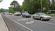 NY 437 begins adjacent to St. Joseph Cemetery
at a traffic circle
with NY 38
in the town of Fleming
, located south of the city of Auburn
. It heads east as White Bridge Road, running along the north end of Owasco Lake
. Roughly midway along its routing, NY 437 crosses the Owasco Outlet and passes into both Owasco
and Emerson Park, a public park owned and maintained by Cayuga County
. The route ends 200 yards (182.9 m) later at a T-intersection with NY 38A
in an area of Owasco known as Melrose Park
. NY 437 serves an undeveloped, forested area west of the outlet and a mostly residential area east of the waterway. The highway is just 0.3 mile (0.482802 km) from end to end, making it the shortest signed state highway in New York.
The route is one of a handful of state-maintained highways in New York to culminate in a traffic circle or roundabout
at one end of the route. NY 635
, in neighboring Onondaga County
, ends at NY 298
and exit 35 of the New York State Thruway
via Carrier Circle, a large traffic circle in Syracuse
. NY 140
west of Albany
ends at a roundabout with NY 85
at its western end. Interstate 587 outside Kingston
also ends at a roundabout with NY 28
and exit 19 of the Thruway. NY 27
also ends in an apparent traffic circle at its eastern terminus on Montauk Point; however, it is merely a closed loop created by the highway running back into itself (the same feature is present on U.S. Route 9 just short of the Canadian border).
with NY 38
to the Owasco Lake
outlet was rebuilt in 1908 as part of State Highway 384 (SH 384), while the section between the outlet and current NY 38A
was reconstructed from 1912 to 1913 as part of SH 752. Both numbers are internal, legislative designations and are thus unsigned
. NY 437 was marked on contemporary maps of the area as a designation for the short east–west state highway as early as 1947; however, the designation was not officially assigned by the New York State Department of Transportation
(NYSDOT) until January 1, 1970.
State highway
State highway, state road or state route can refer to one of three related concepts, two of them related to a state or provincial government in a country that is divided into states or provinces :#A...
located south of Auburn
Auburn, New York
Auburn is a city in Cayuga County, New York, United States of America. As of the 2010 census, the city had a population of 27,687...
in Cayuga County, New York
Cayuga County, New York
Cayuga County is a county located in the U.S. state of New York. It was named for one of the tribes of Indians in the Iroquois Confederation. Its county seat is Auburn.- History :...
, in the United States. At 0.3 mile (0.482802 km) in length, it is the shortest signed state route in New York. It is a brief connector route between NY 38
New York State Route 38
New York State Route 38 is a north–south state highway in the Finger Lakes region of New York in the United States. Its southern terminus is at an intersection with NY 96 in the town of Owego in Tioga County. The northern terminus is at a junction with NY 104A in the town of...
and NY 38A
New York State Route 38A
New York State Route 38A is a north–south state highway located within Onondaga and Cayuga Counties in central New York, United States. The southern terminus of the route is at an intersection with NY 38 in the village of Moravia. Its northern terminus is at a junction with U.S....
known locally as White Bridge Road. The highway allows motorists, especially those wanting quick access to the opposite side of nearby Owasco Lake
Owasco Lake
Owasco Lake is the sixth largest and third easternmost of the Finger Lakes of New York in the United States of America . The name Owasco can be roughly translated from a Mohawk and Iroquois term meaning "crossing"....
, to avoid having to cross the Owasco Outlet further downstream, in the city. NY 437 was assigned in 1970; however, the designation had appeared on maps of the area as early as two decades before.
Route description
St. Joseph Cemetery, Fleming
St. Joseph Cemetery is a Catholic cemetery located just outside of Auburn, New York in the town of Fleming, New York. Former big league baseball player Tug Arundel is buried there....
at a traffic circle
Traffic circle
A traffic circle or rotary is a type of circular intersection in which traffic must travel in one direction around a central island. In some countries, traffic entering the circle has the right-of-way and drivers in the circle must yield. In many other countries, traffic entering the circle must...
with NY 38
New York State Route 38
New York State Route 38 is a north–south state highway in the Finger Lakes region of New York in the United States. Its southern terminus is at an intersection with NY 96 in the town of Owego in Tioga County. The northern terminus is at a junction with NY 104A in the town of...
in the town of Fleming
Fleming, New York
Fleming is a town in Cayuga County, New York, United States. The population was 2,636 at the 2010 census. The name is that of General George Fleming, an early settler.The Town of Fleming is at the north end of Owasco Lake, south of Auburn, New York....
, located south of the city of Auburn
Auburn, New York
Auburn is a city in Cayuga County, New York, United States of America. As of the 2010 census, the city had a population of 27,687...
. It heads east as White Bridge Road, running along the north end of Owasco Lake
Owasco Lake
Owasco Lake is the sixth largest and third easternmost of the Finger Lakes of New York in the United States of America . The name Owasco can be roughly translated from a Mohawk and Iroquois term meaning "crossing"....
. Roughly midway along its routing, NY 437 crosses the Owasco Outlet and passes into both Owasco
Owasco, New York
Owasco is a town in Cayuga County, New York, United States. The population was 3,793 at the 2010 census.The Town of Owasco is in the eastern part of Cayuga County and is at the southeast city line of Auburn, New York. The town borders Owasco Lake, from where it gets its name...
and Emerson Park, a public park owned and maintained by Cayuga County
Cayuga County, New York
Cayuga County is a county located in the U.S. state of New York. It was named for one of the tribes of Indians in the Iroquois Confederation. Its county seat is Auburn.- History :...
. The route ends 200 yards (182.9 m) later at a T-intersection with NY 38A
New York State Route 38A
New York State Route 38A is a north–south state highway located within Onondaga and Cayuga Counties in central New York, United States. The southern terminus of the route is at an intersection with NY 38 in the village of Moravia. Its northern terminus is at a junction with U.S....
in an area of Owasco known as Melrose Park
Melrose Park, New York
Melrose Park is a suburban community in Cayuga County, New York, United States. The population was 2,359 at the 2000 census.Melrose Park is a suburb of Auburn, New York, located south of the city.-Geography:...
. NY 437 serves an undeveloped, forested area west of the outlet and a mostly residential area east of the waterway. The highway is just 0.3 mile (0.482802 km) from end to end, making it the shortest signed state highway in New York.
The route is one of a handful of state-maintained highways in New York to culminate in a traffic circle or roundabout
Roundabout
A roundabout is the name for a road junction in which traffic moves in one direction around a central island. The word dates from the early 20th century. Roundabouts are common in many countries around the world...
at one end of the route. NY 635
New York State Route 635
New York State Route 635 is a state highway located in the vicinity of Syracuse in Onondaga County, New York. The southern terminus of the route is at Erie Boulevard in Syracuse. The northern terminus is at Carrier Circle in DeWitt, where NY 635 connects to both the New York State...
, in neighboring Onondaga County
Onondaga County, New York
Onondaga County is a county located in the U.S. state of New York. As of the 2010 census, the population was 467,026. The county seat is Syracuse.Onondaga County is part of the Syracuse, NY Metropolitan Statistical Area....
, ends at NY 298
New York State Route 298
New York State Route 298 is an east–west state highway located entirely within Onondaga County, New York, in the United States. It runs in a generally northeast direction for from an interchange with Interstate 690 in the city of Syracuse to an intersection with NY 31 near the...
and exit 35 of the New York State Thruway
New York State Thruway
The New York State Thruway is a system of limited-access highways located within the state of New York in the United States. The system, known officially as the Governor Thomas E. Dewey Thruway for former New York Governor Thomas E. Dewey, is operated by the New York State Thruway Authority and...
via Carrier Circle, a large traffic circle in Syracuse
Syracuse, New York
Syracuse is a city in and the county seat of Onondaga County, New York, United States, the largest U.S. city with the name "Syracuse", and the fifth most populous city in the state. At the 2010 census, the city population was 145,170, and its metropolitan area had a population of 742,603...
. NY 140
New York State Route 140
New York State Route 140 is an east–west state highway located entirely within Albany County, New York, in the United States. The highway runs for from NY 85 near the hamlet of Slingerlands to NY 443 in the hamlet of Delmar...
west of Albany
Albany, New York
Albany is the capital city of the U.S. state of New York, the seat of Albany County, and the central city of New York's Capital District. Roughly north of New York City, Albany sits on the west bank of the Hudson River, about south of its confluence with the Mohawk River...
ends at a roundabout with NY 85
New York State Route 85
New York State Route 85 is a state highway in Albany County, New York, in the United States. It is long and runs from County Route 351 and CR 353 in Rensselaerville to Interstate 90 exit 4 in Albany. It also has a loop route, NY 85A, which connects NY 85 to...
at its western end. Interstate 587 outside Kingston
Kingston, New York
Kingston is a city in and the county seat of Ulster County, New York, USA. It is north of New York City and south of Albany. It became New York's first capital in 1777, and was burned by the British Oct. 16, 1777, after the Battles of Saratoga...
also ends at a roundabout with NY 28
New York State Route 28
New York State Route 28 is a state highway extending for in the shape of a "C" between the Hudson Valley city of Kingston and southern Warren County in the U.S. state of New York. Along the way, it intersects several major routes, including Interstate 88 , U.S. Route 20 , and the...
and exit 19 of the Thruway. NY 27
New York State Route 27
New York State Route 27 is an east–west long state highway extending from Interstate 278 in the New York City borough of Brooklyn to Montauk Point State Park on Long Island, New York, United States...
also ends in an apparent traffic circle at its eastern terminus on Montauk Point; however, it is merely a closed loop created by the highway running back into itself (the same feature is present on U.S. Route 9 just short of the Canadian border).
History
What is now NY 437 was originally improved to state highway standards in stages during the early 20th century. The portion from the modern traffic circleTraffic circle
A traffic circle or rotary is a type of circular intersection in which traffic must travel in one direction around a central island. In some countries, traffic entering the circle has the right-of-way and drivers in the circle must yield. In many other countries, traffic entering the circle must...
with NY 38
New York State Route 38
New York State Route 38 is a north–south state highway in the Finger Lakes region of New York in the United States. Its southern terminus is at an intersection with NY 96 in the town of Owego in Tioga County. The northern terminus is at a junction with NY 104A in the town of...
to the Owasco Lake
Owasco Lake
Owasco Lake is the sixth largest and third easternmost of the Finger Lakes of New York in the United States of America . The name Owasco can be roughly translated from a Mohawk and Iroquois term meaning "crossing"....
outlet was rebuilt in 1908 as part of State Highway 384 (SH 384), while the section between the outlet and current NY 38A
New York State Route 38A
New York State Route 38A is a north–south state highway located within Onondaga and Cayuga Counties in central New York, United States. The southern terminus of the route is at an intersection with NY 38 in the village of Moravia. Its northern terminus is at a junction with U.S....
was reconstructed from 1912 to 1913 as part of SH 752. Both numbers are internal, legislative designations and are thus unsigned
Unsigned highway
An unsigned highway is a highway that has been assigned a route number, but does not bear conventional road markings that would normally be used to identify the route with that number...
. NY 437 was marked on contemporary maps of the area as a designation for the short east–west state highway as early as 1947; however, the designation was not officially assigned by the New York State Department of Transportation
New York State Department of Transportation
The New York State Department of Transportation is responsible for the development and operation of highways, railroads, mass transit systems, ports, waterways and aviation facilities in the U.S...
(NYSDOT) until January 1, 1970.