

New York State Route 38A
Encyclopedia
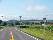
New York State Route 38A (NY 38A) is a north–south state highway
located within Onondaga
and Cayuga
Counties in central New York
, United States
. The southern terminus of the route is at an intersection with NY 38
in the village of Moravia
. Its northern terminus is at a junction with U.S. Route 20 (US 20) and NY 5
in downtown Auburn
. Much of NY 38A runs through rural, undeveloped areas situated between Owasco Lake
and Skaneateles Lake
.
The southern half of NY 38A was originally designated as part of NY 26 in 1924. In the 1930 renumbering of state highways in New York, NY 26 was broken up into several routes, including NY 38A, a new route assigned to NY 26's former alignment between Moravia and Skaneateles and a previously unnumbered highway from Skaneateles to Auburn.
in the village of Moravia
. It proceeds east out of the village on East Cayuga Street and follows it to the vicinity of St. Patrick's Cemetery, where NY 38A turns to follow Decker Creek northward through a valley surrounding the creek. While in the valley, NY 38A passes through mostly undeveloped areas of the towns of Moravia
and Niles
. At Globe Hotel Corners, an extremely small hamlet just north of the Niles town line, NY 38A begins to parallel NY 41A
, which runs roughly 2 miles (3.2 km) to the east of NY 38A along the top of the valley.
 Approximately 2 miles (3.2 km) north of Globe Hotel Corners, NY 38A turns to follow a more northwesterly routing, matching the curvature of the river valley. The valley ends at the Cayuga
–Onondaga
County line, where NY 38A enters an area of flats situated in between Owasco Lake
and Skaneateles Lake
. Here, NY 38A intersects NY 359
, a short highway leading to NY 41A. NY 38A bears west here, traveling to the south of the Dutch Hollow Country Club as it reenters Cayuga County.
The route proceeds west into the town of Owasco
and the hamlet of the same name within, the first community of any significant size along the route since it left Moravia. It heads westward through the center of the community before reentering rural surroundings and coming within view of Owasco Lake. The route curves northward at the waterbody and follows the eastern shore of Owasco Lake
toward Auburn
. Southeast of Auburn, NY 38A crosses a small stream and serves the Lakeview Golf and Country Club and the Owasco Country Club as it curves westward around the northern end of the lake.
At Emerson Park, a public park situated near the midpoint of the northern lakeshore, the highway turns back to the north to access Melrose Park
, a community built up just north of the lake around the Owasco Outlet. Here, NY 38A meets NY 437
, a short connector highway linking NY 38A to its parent, NY 38
. North of Melrose Park, the route becomes known as Owasco Street as it follows the Owasco Outlet into the city of Auburn. At the city line, ownership and maintenance of the route shifts from the New York State Department of Transportation
(NYSDOT) to Auburn. The route heads northeastward through the densely populated city to Walnut Street, where it splits into a one-way couplet along Fulton Street (northbound) and John and Owasco Streets (southbound). One block to the north, NY 38A intersects US 20 at Genesee Street. US 20 joins NY 38A for one block to the Auburn Arterial (NY 5
), where NY 38A comes to an end.
were assigned in 1924, the segment of modern NY 38A between its southern terminus in Moravia
and NY 359
in Skaneateles
was designated as part of NY 26, a north–south highway extending from Ithaca
to Syracuse
. In the 1930 renumbering of state highways in New York, NY 26 was split into several routes. From Dryden
to Moravia, NY 26 became part of NY 38
. Between Moravia and modern NY 359
, it became the southern half of the new NY 38A, an alternate route of NY 38 around the east side of Owasco Lake
that continued from the current NY 359 junction to Auburn
by way of a previously unnumbered roadway.
State highway
State highway, state road or state route can refer to one of three related concepts, two of them related to a state or provincial government in a country that is divided into states or provinces :#A...
located within Onondaga
Onondaga County, New York
Onondaga County is a county located in the U.S. state of New York. As of the 2010 census, the population was 467,026. The county seat is Syracuse.Onondaga County is part of the Syracuse, NY Metropolitan Statistical Area....
and Cayuga
Cayuga County, New York
Cayuga County is a county located in the U.S. state of New York. It was named for one of the tribes of Indians in the Iroquois Confederation. Its county seat is Auburn.- History :...
Counties in central New York
Central New York
Central New York is a term used to broadly describe the central region of New York State, roughly including the following counties and cities:...
, United States
United States
The United States of America is a federal constitutional republic comprising fifty states and a federal district...
. The southern terminus of the route is at an intersection with NY 38
New York State Route 38
New York State Route 38 is a north–south state highway in the Finger Lakes region of New York in the United States. Its southern terminus is at an intersection with NY 96 in the town of Owego in Tioga County. The northern terminus is at a junction with NY 104A in the town of...
in the village of Moravia
Moravia (village), New York
Moravia is a village in Cayuga County, New York, United States. The population was 1,363 at the 2000 census.The Village of Moravia is in the south part of the Town of Moravia and is south of Auburn, New York....
. Its northern terminus is at a junction with U.S. Route 20 (US 20) and NY 5
New York State Route 5
New York State Route 5 is a state highway that extends for across the state of New York in the United States. It begins at the Pennsylvania state line in the Chautauqua County town of Ripley and passes through Buffalo, Syracuse, Utica, Schenectady, and several other smaller cities and...
in downtown Auburn
Auburn, New York
Auburn is a city in Cayuga County, New York, United States of America. As of the 2010 census, the city had a population of 27,687...
. Much of NY 38A runs through rural, undeveloped areas situated between Owasco Lake
Owasco Lake
Owasco Lake is the sixth largest and third easternmost of the Finger Lakes of New York in the United States of America . The name Owasco can be roughly translated from a Mohawk and Iroquois term meaning "crossing"....
and Skaneateles Lake
Skaneateles Lake
Skaneateles Lake is one of the Finger Lakes in central New York in the United States. The name Skaneateles means long lake in one of the local Iroquoian languages. The lake is sometimes referred to as "The Roof Garden of the Lakes" because its altitude is higher than the other Finger Lakes. It...
.
The southern half of NY 38A was originally designated as part of NY 26 in 1924. In the 1930 renumbering of state highways in New York, NY 26 was broken up into several routes, including NY 38A, a new route assigned to NY 26's former alignment between Moravia and Skaneateles and a previously unnumbered highway from Skaneateles to Auburn.
Route description
NY 38A begins at an intersection with NY 38New York State Route 38
New York State Route 38 is a north–south state highway in the Finger Lakes region of New York in the United States. Its southern terminus is at an intersection with NY 96 in the town of Owego in Tioga County. The northern terminus is at a junction with NY 104A in the town of...
in the village of Moravia
Moravia (village), New York
Moravia is a village in Cayuga County, New York, United States. The population was 1,363 at the 2000 census.The Village of Moravia is in the south part of the Town of Moravia and is south of Auburn, New York....
. It proceeds east out of the village on East Cayuga Street and follows it to the vicinity of St. Patrick's Cemetery, where NY 38A turns to follow Decker Creek northward through a valley surrounding the creek. While in the valley, NY 38A passes through mostly undeveloped areas of the towns of Moravia
Moravia (town), New York
Moravia is a town in Cayuga County, New York, United States. The population was 3,626 at the 2010 census.The Town of Moravia contains a village called Moravia...
and Niles
Niles, New York
Niles is a town in Cayuga County, New York, United States. The population was 1,194 at the 2010 census. The Town of Niles lies in the eastern part of the county southeast of Auburn, New York.- History :...
. At Globe Hotel Corners, an extremely small hamlet just north of the Niles town line, NY 38A begins to parallel NY 41A
New York State Route 41A
New York State Route 41A is a north–south New York State Route located within Onondaga, Cayuga, and Cortland Counties in Central New York. Its northern terminus is located at a junction with U.S. Route 20 in the village of Skaneateles in Onondaga County...
, which runs roughly 2 miles (3.2 km) to the east of NY 38A along the top of the valley.
Cayuga County, New York
Cayuga County is a county located in the U.S. state of New York. It was named for one of the tribes of Indians in the Iroquois Confederation. Its county seat is Auburn.- History :...
–Onondaga
Onondaga County, New York
Onondaga County is a county located in the U.S. state of New York. As of the 2010 census, the population was 467,026. The county seat is Syracuse.Onondaga County is part of the Syracuse, NY Metropolitan Statistical Area....
County line, where NY 38A enters an area of flats situated in between Owasco Lake
Owasco Lake
Owasco Lake is the sixth largest and third easternmost of the Finger Lakes of New York in the United States of America . The name Owasco can be roughly translated from a Mohawk and Iroquois term meaning "crossing"....
and Skaneateles Lake
Skaneateles Lake
Skaneateles Lake is one of the Finger Lakes in central New York in the United States. The name Skaneateles means long lake in one of the local Iroquoian languages. The lake is sometimes referred to as "The Roof Garden of the Lakes" because its altitude is higher than the other Finger Lakes. It...
. Here, NY 38A intersects NY 359
New York State Route 359
New York State Route 359 is a state highway located entirely within the town of Skaneateles in Onondaga County, New York in the United States. At in length, it is one of the shortest signed state highways in all of New York...
, a short highway leading to NY 41A. NY 38A bears west here, traveling to the south of the Dutch Hollow Country Club as it reenters Cayuga County.
The route proceeds west into the town of Owasco
Owasco, New York
Owasco is a town in Cayuga County, New York, United States. The population was 3,793 at the 2010 census.The Town of Owasco is in the eastern part of Cayuga County and is at the southeast city line of Auburn, New York. The town borders Owasco Lake, from where it gets its name...
and the hamlet of the same name within, the first community of any significant size along the route since it left Moravia. It heads westward through the center of the community before reentering rural surroundings and coming within view of Owasco Lake. The route curves northward at the waterbody and follows the eastern shore of Owasco Lake
Owasco Lake
Owasco Lake is the sixth largest and third easternmost of the Finger Lakes of New York in the United States of America . The name Owasco can be roughly translated from a Mohawk and Iroquois term meaning "crossing"....
toward Auburn
Auburn, New York
Auburn is a city in Cayuga County, New York, United States of America. As of the 2010 census, the city had a population of 27,687...
. Southeast of Auburn, NY 38A crosses a small stream and serves the Lakeview Golf and Country Club and the Owasco Country Club as it curves westward around the northern end of the lake.
At Emerson Park, a public park situated near the midpoint of the northern lakeshore, the highway turns back to the north to access Melrose Park
Melrose Park, New York
Melrose Park is a suburban community in Cayuga County, New York, United States. The population was 2,359 at the 2000 census.Melrose Park is a suburb of Auburn, New York, located south of the city.-Geography:...
, a community built up just north of the lake around the Owasco Outlet. Here, NY 38A meets NY 437
New York State Route 437
New York State Route 437 is a state highway located south of Auburn in Cayuga County, New York, in the United States. At in length, it is the shortest signed state route in New York. It is a brief connector route between NY 38 and NY 38A known locally as White Bridge Road...
, a short connector highway linking NY 38A to its parent, NY 38
New York State Route 38
New York State Route 38 is a north–south state highway in the Finger Lakes region of New York in the United States. Its southern terminus is at an intersection with NY 96 in the town of Owego in Tioga County. The northern terminus is at a junction with NY 104A in the town of...
. North of Melrose Park, the route becomes known as Owasco Street as it follows the Owasco Outlet into the city of Auburn. At the city line, ownership and maintenance of the route shifts from the New York State Department of Transportation
New York State Department of Transportation
The New York State Department of Transportation is responsible for the development and operation of highways, railroads, mass transit systems, ports, waterways and aviation facilities in the U.S...
(NYSDOT) to Auburn. The route heads northeastward through the densely populated city to Walnut Street, where it splits into a one-way couplet along Fulton Street (northbound) and John and Owasco Streets (southbound). One block to the north, NY 38A intersects US 20 at Genesee Street. US 20 joins NY 38A for one block to the Auburn Arterial (NY 5
New York State Route 5
New York State Route 5 is a state highway that extends for across the state of New York in the United States. It begins at the Pennsylvania state line in the Chautauqua County town of Ripley and passes through Buffalo, Syracuse, Utica, Schenectady, and several other smaller cities and...
), where NY 38A comes to an end.
History
When the first set of posted routes in New YorkNew York
New York is a state in the Northeastern region of the United States. It is the nation's third most populous state. New York is bordered by New Jersey and Pennsylvania to the south, and by Connecticut, Massachusetts and Vermont to the east...
were assigned in 1924, the segment of modern NY 38A between its southern terminus in Moravia
Moravia (village), New York
Moravia is a village in Cayuga County, New York, United States. The population was 1,363 at the 2000 census.The Village of Moravia is in the south part of the Town of Moravia and is south of Auburn, New York....
and NY 359
New York State Route 359
New York State Route 359 is a state highway located entirely within the town of Skaneateles in Onondaga County, New York in the United States. At in length, it is one of the shortest signed state highways in all of New York...
in Skaneateles
Skaneateles (town), New York
Skaneateles is a town in Onondaga County, New York, United States. The population was 7,323 at the 2000 census. The name is from the Iroquois "Indian" tribe term for the adjacent lake: "long lake." The town is on the western border of the county and includes a village, also called Skaneateles...
was designated as part of NY 26, a north–south highway extending from Ithaca
Ithaca, New York
The city of Ithaca, is a city in upstate New York and the county seat of Tompkins County, as well as the largest community in the Ithaca-Tompkins County metropolitan area...
to Syracuse
Syracuse, New York
Syracuse is a city in and the county seat of Onondaga County, New York, United States, the largest U.S. city with the name "Syracuse", and the fifth most populous city in the state. At the 2010 census, the city population was 145,170, and its metropolitan area had a population of 742,603...
. In the 1930 renumbering of state highways in New York, NY 26 was split into several routes. From Dryden
Dryden (village), New York
Dryden is a village in Tompkins County, New York, United States. The population was 1,832 at the 2000 census. The name was assigned by a clerk interested in the classics to honor John Dryden, poet and playwright....
to Moravia, NY 26 became part of NY 38
New York State Route 38
New York State Route 38 is a north–south state highway in the Finger Lakes region of New York in the United States. Its southern terminus is at an intersection with NY 96 in the town of Owego in Tioga County. The northern terminus is at a junction with NY 104A in the town of...
. Between Moravia and modern NY 359
New York State Route 359
New York State Route 359 is a state highway located entirely within the town of Skaneateles in Onondaga County, New York in the United States. At in length, it is one of the shortest signed state highways in all of New York...
, it became the southern half of the new NY 38A, an alternate route of NY 38 around the east side of Owasco Lake
Owasco Lake
Owasco Lake is the sixth largest and third easternmost of the Finger Lakes of New York in the United States of America . The name Owasco can be roughly translated from a Mohawk and Iroquois term meaning "crossing"....
that continued from the current NY 359 junction to Auburn
Auburn, New York
Auburn is a city in Cayuga County, New York, United States of America. As of the 2010 census, the city had a population of 27,687...
by way of a previously unnumbered roadway.