
New York State Route 305
Encyclopedia
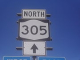
New York State Route 305 (NY 305) is a north–south route in the Southern Tier
that runs from the Pennsylvania state line
in Cattaraugus County
to the hamlet
of Belfast
in Allegany County
, where it ends at NY 19
. It intersects the Southern Tier Expressway (Interstate 86
/NY 17
) in Cuba
.
was originally the southernmost portion of Route 16, an unsigned legislative route
assigned by the New York State Legislature in 1908. At Belfast
, Route 16 continued north on what is now NY 19
. The Cuba–Belfast section of legislative Route 16 was assigned a posted route designation as part of the 1930 renumbering of state highways in New York when it was designated as the northern half of NY 94, which continued south through Cuba to NY 17
(now NY 417
) in Portville
. At the same time, what is now NY 45
in Rockland County
was designated as NY 305. The NY 94 and NY 305 designations were swapped in the early 1940s, placing NY 305 on its current alignment from Portville to Belfast. South of Portville, what is now NY 305 was originally designated as part of NY 16
ca. 1931. It was added to NY 305 ca. 1963 when NY 16 was rerouted south of Olean
to follow what had been NY 16A.
Southern Tier
The Southern Tier is a geographical term that refers to the counties of New York State west of the Catskill Mountains along the northern border of Pennsylvania. It is a loosely defined term that generally includes the counties that border Pennsylvania west of Delaware County inclusive...
that runs from the Pennsylvania state line
New York - Pennsylvania Border
The New York–Pennsylvania border is the state line between the U.S. states of New York and Pennsylvania. It has three sections:* along the center line of the Delaware River from the tri-point with New Jersey at the confluence of the Delaware with the Neversink River in Port Jervis, New York to the...
in Cattaraugus County
Cattaraugus County, New York
Cattaraugus County is a county located in the U.S. state of New York. As of the 2010 census, the population was 80,317. The county seat is Little Valley.-History:...
to the hamlet
Hamlet (place)
A hamlet is usually a rural settlement which is too small to be considered a village, though sometimes the word is used for a different sort of community. Historically, when a hamlet became large enough to justify building a church, it was then classified as a village...
of Belfast
Belfast, New York
Belfast is a town in Allegany County, New York, United States. The population was 1,714 at the 2000 census. It was named after the city of Belfast in Northern Ireland.- History :The first settlers had arrived by 1804....
in Allegany County
Allegany County, New York
Allegany County is a county located in the U.S. state of New York. As of the 2010 census, the population was 48,946. Its name derives from a Delaware Indian word, applied by settlers of Western New York State to a trail that followed the Allegheny River. Its county seat is...
, where it ends at NY 19
New York State Route 19
New York State Route 19 is a north–south state highway in Western New York in the United States. It is the longest state highway in that region, and the only other one besides NY 14 to completely transect the state from the Pennsylvania state line to the shore of Lake Ontario...
. It intersects the Southern Tier Expressway (Interstate 86
Interstate 86 (east)
Interstate 86 is an Interstate Highway that extends for through northwestern Pennsylvania and southern New York in the United States...
/NY 17
New York State Route 17
New York State Route 17 is a state highway that extends for through the Southern Tier and Downstate regions of New York in the United States...
) in Cuba
Cuba (village), New York
Cuba is a village in Allegany County, New York, United States. The population was 1,633 at the 2000 census.The Village of Cuba is in the western part of the Town of Cuba at the junction of Routes 305 and 446 on Oil Creek.- History :...
.
History
The segment of modern NY 305 north of CubaCuba (village), New York
Cuba is a village in Allegany County, New York, United States. The population was 1,633 at the 2000 census.The Village of Cuba is in the western part of the Town of Cuba at the junction of Routes 305 and 446 on Oil Creek.- History :...
was originally the southernmost portion of Route 16, an unsigned legislative route
Legislative route
In United States, a legislative route or legislative highway is a highway defined by laws passed in a state legislature. The numbering of such highways may or may not correspond to the numbers familiar to the public as part of the state, U.S. highway, and Interstate highway systems...
assigned by the New York State Legislature in 1908. At Belfast
Belfast, New York
Belfast is a town in Allegany County, New York, United States. The population was 1,714 at the 2000 census. It was named after the city of Belfast in Northern Ireland.- History :The first settlers had arrived by 1804....
, Route 16 continued north on what is now NY 19
New York State Route 19
New York State Route 19 is a north–south state highway in Western New York in the United States. It is the longest state highway in that region, and the only other one besides NY 14 to completely transect the state from the Pennsylvania state line to the shore of Lake Ontario...
. The Cuba–Belfast section of legislative Route 16 was assigned a posted route designation as part of the 1930 renumbering of state highways in New York when it was designated as the northern half of NY 94, which continued south through Cuba to NY 17
New York State Route 17
New York State Route 17 is a state highway that extends for through the Southern Tier and Downstate regions of New York in the United States...
(now NY 417
New York State Route 417
New York State Route 417 is an east–west state highway located in the Southern Tier of New York in the United States. It begins at exit 20 of the Southern Tier Expressway in the city of Salamanca and ends at a junction with NY 415 in Painted Post, west of the city of Corning...
) in Portville
Portville (village), New York
Portville is a village in Cattaraugus County, New York, USA. The population was 1,024 at the 2000 census. The Village of Portville is within the south part of the Town of Portville and southeast of Olean, New York.- History :...
. At the same time, what is now NY 45
New York State Route 45
New York State Route 45 is a north–south state highway in central Rockland County, New York, United States. It spans from the village of Chestnut Ridge at the New Jersey – New York border, where it becomes County Route 73 in Bergen County, New Jersey, to U.S. Route 202 in...
in Rockland County
Rockland County, New York
Rockland County is a suburban county 15 miles to the northwest of Manhattan and part of the New York City Metropolitan Area, in the U.S. state of New York. It is the southernmost county in New York west of the Hudson River, and the smallest county in New York outside of New York City. The...
was designated as NY 305. The NY 94 and NY 305 designations were swapped in the early 1940s, placing NY 305 on its current alignment from Portville to Belfast. South of Portville, what is now NY 305 was originally designated as part of NY 16
New York State Route 16
New York State Route 16 is a state highway in western New York, United States. It runs from the Pennsylvania state line, where it is one of the highest highways in the state in elevation, to downtown Buffalo. NY 16 is a major route through Erie County, despite the construction of the...
ca. 1931. It was added to NY 305 ca. 1963 when NY 16 was rerouted south of Olean
Olean, New York
Olean is a city in Cattaraugus County, New York, United States. Olean is the largest city in Cattaraugus County, and serves as the financial, business, transportation and entertainment center of the county. It is one of the principal cities of the Southern Tier region of New York.The city is...
to follow what had been NY 16A.