
New York State Route 340
Encyclopedia
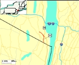
New York State Route 340 (NY 340) is a 3.17 miles (5.1 km) state highway
in southeastern Rockland County, New York
, in the United States. Though it is signed as an east–west route, it actually follows a north–south alignment. The southern terminus of the route is at the New Jersey
state line in Palisades
, where it becomes County Route 501
(CR 501). As signed, the northern terminus is at an intersection with NY 303
in Orangeburg
; however, according to the New York State Department of Transportation
(NYSDOT), the route continues for another 0.07 mile (0.1126538 km) to the northwest of NY 303. NY 340 was assigned to part of its modern routing in the early 1930s and extended to its current length in the early 1940s.
 NY 340 begins at the New Jersey
– New York
border in Palisades
. Directly south of the border is Rockleigh, New Jersey
, in which the route continues as that state's CR 501
. The route heads northward through the town of Orangetown
, serving a residential community before entering a more forested area and crossing over the Palisades Interstate Parkway
(PIP). Not far to the north is the densely populated hamlet of Sparkill
, where the highway passes Rockland Country Club and John O'Rourke Memorial Park. In the center of Sparkill, NY 340 indirectly connects to southbound U.S. Route 9W (US 9W) and meets CR 8, the only county route that NY 340 comes in contact with. Just past the indirect junction with US 9W is an intersection with Ferdon Avenue, where maintenance of NY 340 shifts from NYSDOT
to the town of Orangetown.
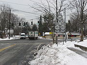
Just 0.11 mile (0.1770274 km) northwest of Ferdon Avenue, the route briefly enters the village of Piermont
, where it remains locally maintained. Here, it indirectly connects to US 9W northbound. Outside of the village limits, NYSDOT resumes maintenance of the highway as it traverses areas more commercial and educational in nature. Along this last stretch, NY 340 passes St. Thomas Aquinas College
before intersecting NY 303
near the hamlet of Orangeburg
. This junction serves as the posted northern terminus of NY 340; however, the route officially continues for another 0.07 mile (0.1126538 km) to a 90-degree turn where Orangeburg Road (NY 340) becomes Greenbush Road. One block north of this point is the eastern terminus of CR 20, which provides access to the PIP from NY 303 and NY 340.
 The portion of modern NY 340 south of Sparkill
was originally designated as part of US 9W
in 1927. At the time, US 9W continued south into New Jersey
on what is now CR 501
and north from Sparkill on its modern alignment. By 1929, US 9W was realigned near the New York – New Jersey state line to run along the Hudson River
from Fort Lee, New Jersey
, to Sparkill. The former routing of US 9W between the state line and Sparkill was designated as NY 340 ca. 1932. NY 340 was extended northwestward to its current northern terminus in the early 1940s.
State highway
State highway, state road or state route can refer to one of three related concepts, two of them related to a state or provincial government in a country that is divided into states or provinces :#A...
in southeastern Rockland County, New York
Rockland County, New York
Rockland County is a suburban county 15 miles to the northwest of Manhattan and part of the New York City Metropolitan Area, in the U.S. state of New York. It is the southernmost county in New York west of the Hudson River, and the smallest county in New York outside of New York City. The...
, in the United States. Though it is signed as an east–west route, it actually follows a north–south alignment. The southern terminus of the route is at the New Jersey
New Jersey
New Jersey is a state in the Northeastern and Middle Atlantic regions of the United States. , its population was 8,791,894. It is bordered on the north and east by the state of New York, on the southeast and south by the Atlantic Ocean, on the west by Pennsylvania and on the southwest by Delaware...
state line in Palisades
Palisades, New York
Palisades, formerly known as Sneden's Landing, is a hamlet in the Town of Orangetown in Rockland County, New York, United States, located north of Rockleigh and Alpine, New Jersey; east of Tappan; south of Sparkill; and west of the Hudson River....
, where it becomes County Route 501
County Route 501 (New Jersey)
County Route 501 is a county highway in New Jersey in two sections spanning Middlesex, Hudson and Bergen Counties. The southern section runs from South Plainfield to Perth Amboy, the northern section runs from Bayonne to Rockleigh, and the two sections are connected by New York State Route 440...
(CR 501). As signed, the northern terminus is at an intersection with NY 303
New York State Route 303
New York State Route 303 is a north–south state highway in eastern Rockland County, New York, in the United States. It begins at the New Jersey state line in the hamlet of Tappan and ends later at an intersection with U.S. Route 9W in Clarkstown...
in Orangeburg
Orangeburg, New York
Orangeburg hamlet , in the Town of Orangetown Rockland County, New York, United States located north of Tappan; south of Blauvelt; east of Pearl River and west of Piermont...
; however, according to the New York State Department of Transportation
New York State Department of Transportation
The New York State Department of Transportation is responsible for the development and operation of highways, railroads, mass transit systems, ports, waterways and aviation facilities in the U.S...
(NYSDOT), the route continues for another 0.07 mile (0.1126538 km) to the northwest of NY 303. NY 340 was assigned to part of its modern routing in the early 1930s and extended to its current length in the early 1940s.
Route description
New Jersey
New Jersey is a state in the Northeastern and Middle Atlantic regions of the United States. , its population was 8,791,894. It is bordered on the north and east by the state of New York, on the southeast and south by the Atlantic Ocean, on the west by Pennsylvania and on the southwest by Delaware...
– New York
New York
New York is a state in the Northeastern region of the United States. It is the nation's third most populous state. New York is bordered by New Jersey and Pennsylvania to the south, and by Connecticut, Massachusetts and Vermont to the east...
border in Palisades
Palisades, New York
Palisades, formerly known as Sneden's Landing, is a hamlet in the Town of Orangetown in Rockland County, New York, United States, located north of Rockleigh and Alpine, New Jersey; east of Tappan; south of Sparkill; and west of the Hudson River....
. Directly south of the border is Rockleigh, New Jersey
Rockleigh, New Jersey
Rockleigh is a borough in Bergen County, New Jersey, United States. As of the United States 2010 Census, the borough population was 531.Rockleigh was incorporated as a borough by an Act of the New Jersey Legislature on March 13, 1923 from portions of Northvale.New Jersey Monthly magazine ranked...
, in which the route continues as that state's CR 501
County Route 501 (New Jersey)
County Route 501 is a county highway in New Jersey in two sections spanning Middlesex, Hudson and Bergen Counties. The southern section runs from South Plainfield to Perth Amboy, the northern section runs from Bayonne to Rockleigh, and the two sections are connected by New York State Route 440...
. The route heads northward through the town of Orangetown
Orangetown, New York
Orangetown is a town in Rockland County, New York, United States located in the southeast part of the county. It is northwest of New York City; north of New Jersey; east of the town of Ramapo; south of the town of Clarkstown; west of the Hudson River. The population was 47,711 at the 2000 census.-...
, serving a residential community before entering a more forested area and crossing over the Palisades Interstate Parkway
Palisades Interstate Parkway
The Palisades Interstate Parkway is a long limited-access highway in the U.S. states of New Jersey and New York. The parkway is a major commuter route into New York City from Rockland and Orange counties in New York and Bergen County in New Jersey...
(PIP). Not far to the north is the densely populated hamlet of Sparkill
Sparkill, New York
Sparkill, formerly known as Tappan Sloat, is an affluent, suburban hamlet in the Town of Orangetown, Rockland County, New York, United States located north of Palisades; east of Tappan; south of Piermont and west of the Hudson River...
, where the highway passes Rockland Country Club and John O'Rourke Memorial Park. In the center of Sparkill, NY 340 indirectly connects to southbound U.S. Route 9W (US 9W) and meets CR 8, the only county route that NY 340 comes in contact with. Just past the indirect junction with US 9W is an intersection with Ferdon Avenue, where maintenance of NY 340 shifts from NYSDOT
New York State Department of Transportation
The New York State Department of Transportation is responsible for the development and operation of highways, railroads, mass transit systems, ports, waterways and aviation facilities in the U.S...
to the town of Orangetown.
Just 0.11 mile (0.1770274 km) northwest of Ferdon Avenue, the route briefly enters the village of Piermont
Piermont, New York
Piermont is a village in Rockland County, New York, United States. Piermont is in the town of Orangetown, located north of the hamlet of Palisades; east of Sparkill and south of Grand View-on-Hudson, on the west bank of the Hudson River. The population was 2,607 at the 2000 census.The village's...
, where it remains locally maintained. Here, it indirectly connects to US 9W northbound. Outside of the village limits, NYSDOT resumes maintenance of the highway as it traverses areas more commercial and educational in nature. Along this last stretch, NY 340 passes St. Thomas Aquinas College
St. Thomas Aquinas College
St. Thomas Aquinas College is a private four-year liberal arts college in Rockland County, New York that occupies a forty-eight acre campus. Located at 125 Route 340 in Sparkill, New York, the college is named after the medieval philosopher and theologian Thomas Aquinas...
before intersecting NY 303
New York State Route 303
New York State Route 303 is a north–south state highway in eastern Rockland County, New York, in the United States. It begins at the New Jersey state line in the hamlet of Tappan and ends later at an intersection with U.S. Route 9W in Clarkstown...
near the hamlet of Orangeburg
Orangeburg, New York
Orangeburg hamlet , in the Town of Orangetown Rockland County, New York, United States located north of Tappan; south of Blauvelt; east of Pearl River and west of Piermont...
. This junction serves as the posted northern terminus of NY 340; however, the route officially continues for another 0.07 mile (0.1126538 km) to a 90-degree turn where Orangeburg Road (NY 340) becomes Greenbush Road. One block north of this point is the eastern terminus of CR 20, which provides access to the PIP from NY 303 and NY 340.
History
Sparkill, New York
Sparkill, formerly known as Tappan Sloat, is an affluent, suburban hamlet in the Town of Orangetown, Rockland County, New York, United States located north of Palisades; east of Tappan; south of Piermont and west of the Hudson River...
was originally designated as part of US 9W
U.S. Route 9W
U.S. Route 9W is a north–south U.S. Highway in the states of New Jersey and New York. It begins on Fletcher Avenue in Fort Lee, New Jersey as it crosses the US 1 & 9, US 46, and the Interstate 95 approaches to the George Washington Bridge, where it heads north up the west...
in 1927. At the time, US 9W continued south into New Jersey
New Jersey
New Jersey is a state in the Northeastern and Middle Atlantic regions of the United States. , its population was 8,791,894. It is bordered on the north and east by the state of New York, on the southeast and south by the Atlantic Ocean, on the west by Pennsylvania and on the southwest by Delaware...
on what is now CR 501
County Route 501 (New Jersey)
County Route 501 is a county highway in New Jersey in two sections spanning Middlesex, Hudson and Bergen Counties. The southern section runs from South Plainfield to Perth Amboy, the northern section runs from Bayonne to Rockleigh, and the two sections are connected by New York State Route 440...
and north from Sparkill on its modern alignment. By 1929, US 9W was realigned near the New York – New Jersey state line to run along the Hudson River
Hudson River
The Hudson is a river that flows from north to south through eastern New York. The highest official source is at Lake Tear of the Clouds, on the slopes of Mount Marcy in the Adirondack Mountains. The river itself officially begins in Henderson Lake in Newcomb, New York...
from Fort Lee, New Jersey
Fort Lee, New Jersey
Fort Lee is a borough in Bergen County, New Jersey, United States. As of the 2010 United States Census, the borough population was 35,345. Located atop the Hudson Palisades, the borough is the western terminus of the George Washington Bridge...
, to Sparkill. The former routing of US 9W between the state line and Sparkill was designated as NY 340 ca. 1932. NY 340 was extended northwestward to its current northern terminus in the early 1940s.