
New York State Route 240
Encyclopedia
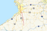
New York State Route 240 (NY 240) is a 51.64 miles (83.11 km) state highway
in western New York
in the United States
. The southern terminus of the route is at an intersection with NY 242
in the Ellicottville
community of Ashford in northern Cattaraugus County
. Its northern terminus is at a junction with NY 324
and Interstate 290
(I-290) in Amherst
in northern Erie County
. The route passes through the villages of Springville
and Orchard Park
, where it meets NY 39
and U.S. Route 20A
(US 20A), respectively. Much of NY 240 between Concord
and Aurora
follows the west branch of Cazenovia Creek
. The northern part of NY 240 in Erie County, named Harlem Road, is a major north–south route through the suburb
s east of the city of Buffalo
.
From its southern terminus at NY 242 to the hamlet of Glenwood
in the town of Colden, NY 240 is a state highway in name only as the roadway is maintained by the highway departments of Cattaraugus
and Erie
Counties. Within Cattaraugus County, NY 242 is co-designated as County Route 32 (CR 32). CR 32 is the only route that has a marked concurrency with a state route in the county. At the county line, it becomes County Route 198 and, later, County Route 30 before becoming state-maintained in Glenwood.
to CR 32 throughout Cattaraugus County, continues to the north as West Valley
Road. As NY 240 passes over Cattaraugus Creek and enters Erie County, it becomes known as Vaughn Street.
In the village of Springville
, NY 240 intersects with NY 39
(East Main Street). At its intersection with Genesee Road in East Concord, it briefly follows Allen Road to the northeast before splitting to the northwest as Glenwood – East Concord Road. In Glenwood, NY 240 becomes State Road then, in West Falls, Davis Road upon passing Knapp Road. At Ellicott Road, NY 240 turns west, following the roadway to the vicinity of Orchard Park
. At Powers Road south of the village, NY 240 turns northwest, following Ellicott Road to an intersection with NY 277
(Chestnut Ridge Road). NY 240 merges with NY 277, forming a concurrency into Orchard Park. The two routes become known as Buffalo Road through the village of Orchard Park, meeting US 20A
(Quaker Street) in the middle of the village. North of the village in the town of Orchard Park
, NY 240 and NY 277 intersect Mile Strip Road, a major east–west arterial during Buffalo Bills
home games. To the north of Mile Strip is US 20
(Southwestern Boulevard), followed by the split of the concurrency just north of US 20. While NY 277 (Union Road) heads due north, NY 240 turns northwest and becomes Orchard Park Road.
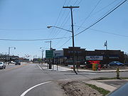
Now in the town of West Seneca
, NY 240 meets NY 16
(Seneca Street), where it becomes known as Harlem Road for the remainder of its routing. After traversing NY 400
(the Aurora Expressway) with no connection to the freeway, NY 240 intersects NY 354
(Clinton Street) near Cheektowaga. The route then passes underneath the New York State Thruway
(I-90) with no connection and enters Cheektowaga.
 Just outside of the Cheektowaga village of Sloan
, NY 240 connects to NY 130
(Broadway) by way of an interchange in the shadow of the CSX Transportation
-owned Frontier Yard, the largest railroad yard in the city. NY 240 continues north, passing over the CSX Buffalo Terminal Subdivision and intersecting Walden Avenue northeast of the yard and northwest of the Walden Galleria
. To the north of the mall and west of the Buffalo Niagara International Airport
, NY 240 intersects both the former routing of NY 33
at Genesee Street and its current routing slightly north of Genesee on the Kensington Expressway.
.jpg) North of the expressway, NY 240 passes through a series rotaries near the Cheektowaga town line with Amherst
North of the expressway, NY 240 passes through a series rotaries near the Cheektowaga town line with Amherst
in the hamlet of Snyder
. Then, NY 240 enters the heart of Amherst where it intersects the Snyder business district, meeting NY 5
(Main Street). Heading north, NY 240 continues onward to its northern terminus at the intersection of NY 324
(Sheridan Drive) and I-290
(Youngmann Expressway) in Amherst.
east of Springville
to NY 18
southeast of downtown Buffalo
. Instead of turning north onto Harlem Road as it does today, NY 240 continued northwest on Potter and Abbott Roads to South Park Avenue (then NY 18). At the time, the portion of modern NY 240 south of Cattaraugus Street in Springville was designated as part of NY 62 while the portion south of Cattaraugus County Route 16 in West Valley
was also part of NY 242. NY 242 was moved onto its modern routing between Ashford
and Machias
by the following year while NY 62 was mostly renumbered to NY 75
ca. 1932.
US 219
was extended into New York ca. 1935, overlapping NY 75 between Ashford and Springville. The overlap with NY 75 was eliminated by 1940 when NY 75 was truncated northward to US 62
in Hamburg. In the mid-1950s, US 219 was shifted westward onto a new highway between Ellicottville
and Springville; however, NY 240 was not extended south to Ashford over its former routing until the mid-1960s. In the Buffalo area, NY 240 was extended northwestward along South Park Avenue to Main Street, which carried NY 5
at the time, in the late 1930s. Ca. 1962, it was altered to follow Harlem Road across Cazenovia Creek
to Seneca Street, where it ended at NY 16
. NY 240 was extended northward along Harlem Road to NY 324
in Amherst
in the mid-1960s. The portion of NY 240's former routing on Potter Road between the Buffalo city line and Harlem Road is now NY 950M, an unsigned reference route.
State highway
State highway, state road or state route can refer to one of three related concepts, two of them related to a state or provincial government in a country that is divided into states or provinces :#A...
in western New York
Western New York
Western New York is the westernmost region of the state of New York. It includes the cities of Buffalo, Rochester, Niagara Falls, the surrounding suburbs, as well as the outlying rural areas of the Great Lakes lowlands, the Genesee Valley, and the Southern Tier. Some historians, scholars and others...
in the United States
United States
The United States of America is a federal constitutional republic comprising fifty states and a federal district...
. The southern terminus of the route is at an intersection with NY 242
New York State Route 242
New York State Route 242 is a state highway that runs across Cattaraugus County, New York, in the United States. Although signed as an east–west route, it takes a more northeast–southwest course across the county from NY 394 near the village of Randolph to NY 16 in Machias...
in the Ellicottville
Ellicottville (town), New York
Ellicottville is a town in Cattaraugus County, New York, United States. The population was 1,738 at the 2000 census. The town is named after Joseph Ellicott, principal land agent of the Holland Land Company....
community of Ashford in northern Cattaraugus County
Cattaraugus County, New York
Cattaraugus County is a county located in the U.S. state of New York. As of the 2010 census, the population was 80,317. The county seat is Little Valley.-History:...
. Its northern terminus is at a junction with NY 324
New York State Route 324
New York State Route 324 is an east–west state highway located in the western portion of New York in the United States...
and Interstate 290
Interstate 290 (New York)
Interstate 290 runs for near Buffalo, New York from I-90 to I-190. It connects Buffalo with its northern suburbs of Amherst and Tonawanda, and provides a route to Niagara Falls that bypasses the city of Buffalo. I-290 also connects to Interstate 990, and through this connection,...
(I-290) in Amherst
Amherst, New York
Amherst is a town in Erie County, New York, United States. As of the 2010 census, the town had a total population of 122,366. This represents an increase of 5.0% from the 2000 census. The town is named for Jeffrey Amherst, a British Army officer of the colonial period...
in northern Erie County
Erie County, New York
Erie County is a county located in the U.S. state of New York. As of the 2010 census, the population was 919,040. The county seat is Buffalo. The county's name comes from Lake Erie, which in turn comes from the Erie tribe of American Indians who lived south and east of the lake before 1654.Erie...
. The route passes through the villages of Springville
Springville, New York
Springville is a village in the southeast part of the town of Concord in Erie County, New York, United States. Springville is the principal community in the town and a major business location in south Erie County. The population was 4,252 at the 2000 census. It is part of the Buffalo–Niagara...
and Orchard Park
Orchard Park (village), New York
Orchard Park is a village in Erie County, New York, United States. The population was 3,294 at the 2000 census. The name is derived from a description of the local landscape, which abounded with orchards...
, where it meets NY 39
New York State Route 39
New York State Route 39 is an east–west state highway in the western portion of New York in the United States. It begins and ends at intersections with U.S. Route 20 apart...
and U.S. Route 20A
U.S. Route 20A (New York)
U.S. Route 20A is an east–west alternate route of US 20 that extends for across the western portion of New York in the United States. It leaves US 20 in Hamburg, a suburb of Buffalo, and rejoins it in East Bloomfield about five miles west of Canandaigua, the county seat of...
(US 20A), respectively. Much of NY 240 between Concord
Concord, New York
Concord is a town in Erie County, New York, United States. The population was 8,526 at the 2000 census. The town is believed to be named after Concord, Massachusetts by early settlers from New England....
and Aurora
Aurora, Erie County, New York
Aurora is a town in Erie County, New York, United States. The population was 13,996 at the 2000 census.The Town of Aurora is one of the "Southtowns" of Erie County and is also erroneously called East Aurora, the name of its principal village...
follows the west branch of Cazenovia Creek
Cazenovia Creek
Cazenovia Creek is a small stream in Western New York, United States. The creek is named after Theophilus Cazenove, an agent of the Holland Land Company. Cazenovia Creek is a tributary of the Buffalo River, which empties into Lake Erie...
. The northern part of NY 240 in Erie County, named Harlem Road, is a major north–south route through the suburb
Suburb
The word suburb mostly refers to a residential area, either existing as part of a city or as a separate residential community within commuting distance of a city . Some suburbs have a degree of administrative autonomy, and most have lower population density than inner city neighborhoods...
s east of the city of Buffalo
Buffalo, New York
Buffalo is the second most populous city in the state of New York, after New York City. Located in Western New York on the eastern shores of Lake Erie and at the head of the Niagara River across from Fort Erie, Ontario, Buffalo is the seat of Erie County and the principal city of the...
.
From its southern terminus at NY 242 to the hamlet of Glenwood
Glenwood, New York
Glenwood, New York is a small, unincorporated hamlet in southern Erie County, New York. Straddling the Towns of Sardinia and Colden, it lies on New York State Route 240 and includes such places as Sprague Brook Park and the well-known Kissing Bridge Ski Area....
in the town of Colden, NY 240 is a state highway in name only as the roadway is maintained by the highway departments of Cattaraugus
Cattaraugus County, New York
Cattaraugus County is a county located in the U.S. state of New York. As of the 2010 census, the population was 80,317. The county seat is Little Valley.-History:...
and Erie
Erie County, New York
Erie County is a county located in the U.S. state of New York. As of the 2010 census, the population was 919,040. The county seat is Buffalo. The county's name comes from Lake Erie, which in turn comes from the Erie tribe of American Indians who lived south and east of the lake before 1654.Erie...
Counties. Within Cattaraugus County, NY 242 is co-designated as County Route 32 (CR 32). CR 32 is the only route that has a marked concurrency with a state route in the county. At the county line, it becomes County Route 198 and, later, County Route 30 before becoming state-maintained in Glenwood.
Route description
NY 240 begins at an intersection with NY 242 in the community of Ashford. NY 240, concurrentConcurrency (road)
A concurrency, overlap, or coincidence in a road network is an instance of one physical road bearing two or more different highway, motorway, or other route numbers...
to CR 32 throughout Cattaraugus County, continues to the north as West Valley
West Valley, New York
West Valley is a hamlet located within the town of Ashford in Cattaraugus County, New York, United States. Located at the intersection of Cattaraugus County Route 53 and State Route 240, the hamlet is home to West Valley Central School and the West Valley Demonstration Project, a nuclear cleanup...
Road. As NY 240 passes over Cattaraugus Creek and enters Erie County, it becomes known as Vaughn Street.
In the village of Springville
Springville, New York
Springville is a village in the southeast part of the town of Concord in Erie County, New York, United States. Springville is the principal community in the town and a major business location in south Erie County. The population was 4,252 at the 2000 census. It is part of the Buffalo–Niagara...
, NY 240 intersects with NY 39
New York State Route 39
New York State Route 39 is an east–west state highway in the western portion of New York in the United States. It begins and ends at intersections with U.S. Route 20 apart...
(East Main Street). At its intersection with Genesee Road in East Concord, it briefly follows Allen Road to the northeast before splitting to the northwest as Glenwood – East Concord Road. In Glenwood, NY 240 becomes State Road then, in West Falls, Davis Road upon passing Knapp Road. At Ellicott Road, NY 240 turns west, following the roadway to the vicinity of Orchard Park
Orchard Park (village), New York
Orchard Park is a village in Erie County, New York, United States. The population was 3,294 at the 2000 census. The name is derived from a description of the local landscape, which abounded with orchards...
. At Powers Road south of the village, NY 240 turns northwest, following Ellicott Road to an intersection with NY 277
New York State Route 277
New York State Route 277 is a state highway in New York, USA. This highway is also called Union Road, along with other names. NY 277 is a major north–south road east of Buffalo, New York, through the middle of Erie County...
(Chestnut Ridge Road). NY 240 merges with NY 277, forming a concurrency into Orchard Park. The two routes become known as Buffalo Road through the village of Orchard Park, meeting US 20A
U.S. Route 20A (New York)
U.S. Route 20A is an east–west alternate route of US 20 that extends for across the western portion of New York in the United States. It leaves US 20 in Hamburg, a suburb of Buffalo, and rejoins it in East Bloomfield about five miles west of Canandaigua, the county seat of...
(Quaker Street) in the middle of the village. North of the village in the town of Orchard Park
Orchard Park (town), New York
Orchard Park is a town in Erie County, New York, a suburb southeast of Buffalo, New York. According to the 2010 census, the population is 29,054. This represents an increase of 5.13% from the 2000 census figure. The town contains a village also named Orchard Park. Orchard Park is one of the...
, NY 240 and NY 277 intersect Mile Strip Road, a major east–west arterial during Buffalo Bills
Buffalo Bills
The Buffalo Bills are a professional football team based in Buffalo, New York. They are currently members of the East Division of the American Football Conference in the National Football League...
home games. To the north of Mile Strip is US 20
U.S. Route 20 in New York
U.S. Route 20 is a part of the U.S. Highway System that runs from Newport, Oregon, to Boston, Massachusetts. In the U.S. state of New York, US 20 extends from the Pennsylvania state line at Ripley to the Massachusetts state line in the Berkshire Mountains. US 20 is the longest...
(Southwestern Boulevard), followed by the split of the concurrency just north of US 20. While NY 277 (Union Road) heads due north, NY 240 turns northwest and becomes Orchard Park Road.
Now in the town of West Seneca
West Seneca, New York
West Seneca is a town in Erie County, New York, United States. The population was 44,711 at the 2010 census. West Seneca is a centrally-located interior town of the county, and a suburb of Buffalo...
, NY 240 meets NY 16
New York State Route 16
New York State Route 16 is a state highway in western New York, United States. It runs from the Pennsylvania state line, where it is one of the highest highways in the state in elevation, to downtown Buffalo. NY 16 is a major route through Erie County, despite the construction of the...
(Seneca Street), where it becomes known as Harlem Road for the remainder of its routing. After traversing NY 400
New York State Route 400
New York State Route 400 is a state highway located within Erie County, New York, in the United States. The northwest end is connected to the New York State Thruway and the southeast end terminates at NY 16 in the town of Aurora. NY 400, a limited-access highway, roughly parallels...
(the Aurora Expressway) with no connection to the freeway, NY 240 intersects NY 354
New York State Route 354
New York State Route 354 is a state highway in New York, USA. NY 354 is one of several highways radiating eastward from its western terminus in downtown Buffalo, New York. The east terminus of NY 354 is in the Village of Attica, where it ends at NY 98 and NY 238 as West...
(Clinton Street) near Cheektowaga. The route then passes underneath the New York State Thruway
New York State Thruway
The New York State Thruway is a system of limited-access highways located within the state of New York in the United States. The system, known officially as the Governor Thomas E. Dewey Thruway for former New York Governor Thomas E. Dewey, is operated by the New York State Thruway Authority and...
(I-90) with no connection and enters Cheektowaga.
Sloan, New York
Sloan is a village in Erie County, New York, United States. The population was 3,775 at the 2000 census. It is part of the Buffalo–Niagara Falls Metropolitan Statistical Area....
, NY 240 connects to NY 130
New York State Route 130
New York State Route 130 is a state highway entirely within Erie County, New York, United States. It runs east–west from U.S. Route 62 in Buffalo to the village of Depew, where it terminates at NY 78...
(Broadway) by way of an interchange in the shadow of the CSX Transportation
CSX Transportation
CSX Transportation operates a Class I railroad in the United States known as the CSX Railroad. It is the main subsidiary of the CSX Corporation. The company is headquartered in Jacksonville, Florida, and owns approximately 21,000 route miles...
-owned Frontier Yard, the largest railroad yard in the city. NY 240 continues north, passing over the CSX Buffalo Terminal Subdivision and intersecting Walden Avenue northeast of the yard and northwest of the Walden Galleria
Walden Galleria
Walden Galleria is an enclosed shopping mall located in the town of Cheektowaga, New York. Walden Galleria comprises more than of retail space, with 250 stores on two levels, including a food court and a movie theater. Anchor stores include Best Buy, Dick's Sporting Goods, DSW Shoe Warehouse,...
. To the north of the mall and west of the Buffalo Niagara International Airport
Buffalo Niagara International Airport
Buffalo Niagara International Airport is an airport located in Cheektowaga CDP, Town of Cheektowaga, in Erie County, New York, USA. It is named after the Buffalo – Niagara Falls metropolitan area. The airport serves Buffalo, New York as well as Southern Ontario, Canada...
, NY 240 intersects both the former routing of NY 33
New York State Route 33
New York State Route 33 is an east–west state highway in western New York in the United States. The route extends for just under from NY 5 in Buffalo in the west to NY 31 in Rochester in the east. It is, in fact, the only state highway that directly connects both cities, although...
at Genesee Street and its current routing slightly north of Genesee on the Kensington Expressway.
Amherst, New York
Amherst is a town in Erie County, New York, United States. As of the 2010 census, the town had a total population of 122,366. This represents an increase of 5.0% from the 2000 census. The town is named for Jeffrey Amherst, a British Army officer of the colonial period...
in the hamlet of Snyder
Snyder, New York
Snyder is a hamlet within the town of Amherst in Erie County, New York, United States that is part of the Buffalo – Niagara Falls metropolitan area. The hamlet was established in 1837...
. Then, NY 240 enters the heart of Amherst where it intersects the Snyder business district, meeting NY 5
New York State Route 5
New York State Route 5 is a state highway that extends for across the state of New York in the United States. It begins at the Pennsylvania state line in the Chautauqua County town of Ripley and passes through Buffalo, Syracuse, Utica, Schenectady, and several other smaller cities and...
(Main Street). Heading north, NY 240 continues onward to its northern terminus at the intersection of NY 324
New York State Route 324
New York State Route 324 is an east–west state highway located in the western portion of New York in the United States...
(Sheridan Drive) and I-290
Interstate 290 (New York)
Interstate 290 runs for near Buffalo, New York from I-90 to I-190. It connects Buffalo with its northern suburbs of Amherst and Tonawanda, and provides a route to Niagara Falls that bypasses the city of Buffalo. I-290 also connects to Interstate 990, and through this connection,...
(Youngmann Expressway) in Amherst.
History
NY 240 was assigned as part of the 1930 renumbering of state highways in New York to an alignment extending from NY 39New York State Route 39
New York State Route 39 is an east–west state highway in the western portion of New York in the United States. It begins and ends at intersections with U.S. Route 20 apart...
east of Springville
Springville, New York
Springville is a village in the southeast part of the town of Concord in Erie County, New York, United States. Springville is the principal community in the town and a major business location in south Erie County. The population was 4,252 at the 2000 census. It is part of the Buffalo–Niagara...
to NY 18
New York State Route 18
New York State Route 18 is an east–west state highway in western New York in the United States. It runs parallel to the south shore of Lake Ontario for most of its length between Niagara County and Monroe County...
southeast of downtown Buffalo
Buffalo, New York
Buffalo is the second most populous city in the state of New York, after New York City. Located in Western New York on the eastern shores of Lake Erie and at the head of the Niagara River across from Fort Erie, Ontario, Buffalo is the seat of Erie County and the principal city of the...
. Instead of turning north onto Harlem Road as it does today, NY 240 continued northwest on Potter and Abbott Roads to South Park Avenue (then NY 18). At the time, the portion of modern NY 240 south of Cattaraugus Street in Springville was designated as part of NY 62 while the portion south of Cattaraugus County Route 16 in West Valley
West Valley, New York
West Valley is a hamlet located within the town of Ashford in Cattaraugus County, New York, United States. Located at the intersection of Cattaraugus County Route 53 and State Route 240, the hamlet is home to West Valley Central School and the West Valley Demonstration Project, a nuclear cleanup...
was also part of NY 242. NY 242 was moved onto its modern routing between Ashford
Ashford, New York
Ashford is a town in Cattaraugus County, New York, United States. The population was 2,223 at the 2000 census.The Town of Ashford is on the county's northern border.- History :...
and Machias
Machias, New York
Machias is a town in Cattaraugus County, New York, United States. The population was 2,482 at the 2000 census.The Town of Machias is an interior town in the northeast quadrant of the county. It is northeast of the city of Salamanca.-History:...
by the following year while NY 62 was mostly renumbered to NY 75
New York State Route 75
New York State Route 75 is a north–south state highway in Erie County, New York, in the United States. It extends for from an intersection with NY 39 in the Collins hamlet of Collins Center to an interchange with NY 5 in the town of Hamburg...
ca. 1932.
US 219
U.S. Route 219 in New York
U.S. Route 219 is a part of the U.S. Highway System that runs from Rich Creek, Virginia, to West Seneca, New York. In the U.S. state of New York, US 219 extends from the Pennsylvania state line at Carrollton to an interchange with the New York State Thruway at exit 55 in West...
was extended into New York ca. 1935, overlapping NY 75 between Ashford and Springville. The overlap with NY 75 was eliminated by 1940 when NY 75 was truncated northward to US 62
U.S. Route 62 in New York
U.S. Route 62 is a part of the U.S. Highway System that runs from the United States – Mexico border at El Paso, Texas, to Niagara Falls, New York. In the U.S. state of New York, US 62 extends from the New York – Pennsylvania border south of Jamestown to an intersection with...
in Hamburg. In the mid-1950s, US 219 was shifted westward onto a new highway between Ellicottville
Ellicottville, New York
Ellicottville, New York is the name of two places in Cattaraugus County, New York:*Ellicottville , New York*Ellicottville , New YorkBoth locations are named after Joseph Ellicott, an agent for the Holland Land Company....
and Springville; however, NY 240 was not extended south to Ashford over its former routing until the mid-1960s. In the Buffalo area, NY 240 was extended northwestward along South Park Avenue to Main Street, which carried NY 5
New York State Route 5
New York State Route 5 is a state highway that extends for across the state of New York in the United States. It begins at the Pennsylvania state line in the Chautauqua County town of Ripley and passes through Buffalo, Syracuse, Utica, Schenectady, and several other smaller cities and...
at the time, in the late 1930s. Ca. 1962, it was altered to follow Harlem Road across Cazenovia Creek
Cazenovia Creek
Cazenovia Creek is a small stream in Western New York, United States. The creek is named after Theophilus Cazenove, an agent of the Holland Land Company. Cazenovia Creek is a tributary of the Buffalo River, which empties into Lake Erie...
to Seneca Street, where it ended at NY 16
New York State Route 16
New York State Route 16 is a state highway in western New York, United States. It runs from the Pennsylvania state line, where it is one of the highest highways in the state in elevation, to downtown Buffalo. NY 16 is a major route through Erie County, despite the construction of the...
. NY 240 was extended northward along Harlem Road to NY 324
New York State Route 324
New York State Route 324 is an east–west state highway located in the western portion of New York in the United States...
in Amherst
Amherst, New York
Amherst is a town in Erie County, New York, United States. As of the 2010 census, the town had a total population of 122,366. This represents an increase of 5.0% from the 2000 census. The town is named for Jeffrey Amherst, a British Army officer of the colonial period...
in the mid-1960s. The portion of NY 240's former routing on Potter Road between the Buffalo city line and Harlem Road is now NY 950M, an unsigned reference route.