
New York State Route 277
Encyclopedia
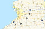
New York State Route 277 (NY 277) is a state highway
in New York
, USA. This highway is also called Union Road, along with other names. NY 277 is a major north–south road east of Buffalo, New York
, through the middle of Erie County
. The section of NY 277 north of Orchard Park
used to be New York State Route 18B until the portion of NY 18 south of Niagara Falls
was deleted.
in the community of North Boston
. This intersection also serves as the southern terminus for NY 391. NY 277 continues to the northeast as Herman Hill Road and Boston Ridge Road before turning to the north at an intersection with CR 552, becoming Chestnut Ridge Road.
In the village of Orchard Park
, NY 277 meets NY 240
south of the village center. The two routes form a concurrency along Buffalo Road through the village, meeting U.S. Route 20A
in the middle of the village. North of the village in the town of Orchard Park
, NY 240/277 meets Milestrip Road, a major east–west arterial during Buffalo Bills
home games. To the north of Milestrip is U.S. Route 20, followed by the split of the concurrency just north of US 20. While NY 240 heads northwest toward downtown Buffalo, NY 277 continues due north and becomes Union Road.
 Now in the town of West Seneca
, NY 277 meets NY 16
as well as NY 400
, the Aurora Expressway, which parallels NY 16 for most of its length. North of town is a junction with NY 354
in the hamlet of Gardenville, its last major intersection before entering Cheektowaga.
Near the east end of CSX's Frontier Yard in downtown Buffalo, NY 277 connects to NY 130
by way of an interchange in the neighborhood of Forks. The interchange was created out of necessity, as NY 277 has to ascend onto a bridge to traverse the CSX Buffalo Terminal Subdivision mainline, which is four tracks wide in this location. Just north of the tracks is Walden Avenue and the Walden Galleria
, which is bordered on its east side by NY 277.
To the north of the mall and west of the Buffalo Niagara International Airport
, NY 277 intersects both the former routing of NY 33
at Genesee Street and its current routing slightly north of Genesee on the Kensington Expressway. Northwest of the airport, NY 277 passes over the New York State Thruway
(Interstate 90) near the Williamsville
toll barrier.
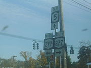
North of the Thruway, NY 277 enters the heart of Amherst
, meeting NY 5
near the western edge of the Village of Williamsville
. Heading north, NY 277 becomes North Forest Road and begins to curve to the northwest, deviating from its perfect north–south alignment that it takes through most of the Buffalo suburbs. NY 277 continues on a northwest track as it comes to an end at NY 324
, better known as Sheridan Drive, in Amherst.
in Gardenville and Genesee Street (then NY 33
) in Cheektowaga was designated as part of NY 355, a route that continued north to Williamsville
by way of Genesee Street and Cayuga Road. At the same time, the section of Union Road in northern Orchard Park
was designated as part of NY 240
. NY 277, meanwhile, was assigned by the following year to the portion of its modern routing from Boston
north to NY 240 south of the village of Orchard Park
.
Ca. 1935, the Union Road portion of NY 355 was incorporated into NY 18B, an alternate route of NY 18
that began at NY 240 in Orchard Park and followed what is now NY 277 north to Sheridan Drive (NY 324
). From there, NY 18B followed NY 324 west to Bailey Avenue, where it connected to NY 18. NY 355 was truncated northward to the eastern terminus of its overlap with NY 33 as a result. The NY 355 designation was completely removed ca. 1937. Ca. 1962, NY 18 was truncated to Lewiston on its western end, leading to the removal of the NY 18B designation. The portion of the route's former alignment that did not overlap NY 324 became a northward extension of NY 277.
State highway
State highway, state road or state route can refer to one of three related concepts, two of them related to a state or provincial government in a country that is divided into states or provinces :#A...
in New York
New York
New York is a state in the Northeastern region of the United States. It is the nation's third most populous state. New York is bordered by New Jersey and Pennsylvania to the south, and by Connecticut, Massachusetts and Vermont to the east...
, USA. This highway is also called Union Road, along with other names. NY 277 is a major north–south road east of Buffalo, New York
Buffalo, New York
Buffalo is the second most populous city in the state of New York, after New York City. Located in Western New York on the eastern shores of Lake Erie and at the head of the Niagara River across from Fort Erie, Ontario, Buffalo is the seat of Erie County and the principal city of the...
, through the middle of Erie County
Erie County, New York
Erie County is a county located in the U.S. state of New York. As of the 2010 census, the population was 919,040. The county seat is Buffalo. The county's name comes from Lake Erie, which in turn comes from the Erie tribe of American Indians who lived south and east of the lake before 1654.Erie...
. The section of NY 277 north of Orchard Park
Orchard Park (village), New York
Orchard Park is a village in Erie County, New York, United States. The population was 3,294 at the 2000 census. The name is derived from a description of the local landscape, which abounded with orchards...
used to be New York State Route 18B until the portion of NY 18 south of Niagara Falls
Niagara Falls, New York
Niagara Falls is a city in Niagara County, New York, United States. As of the 2010 census, the city had a total population of 50,193, down from the 55,593 recorded in the 2000 census. It is across the Niagara River from Niagara Falls, Ontario , both named after the famed Niagara Falls which they...
was deleted.
Route description
NY 277 begins at an intersection with NY 391New York State Route 391
New York State Route 391 is a short state highway in Erie County, New York, United States. The route is signed as north–south; however, it follows more of a southeast–northwest alignment between NY 277 in the hamlet of North Boston and U.S. Route 62 in the village of Hamburg...
in the community of North Boston
North Boston, New York
North Boston is a hamlet located in the Town of Boston in Erie County, New York, United States. As of the 2000 census, this hamlet population was 2,680...
. This intersection also serves as the southern terminus for NY 391. NY 277 continues to the northeast as Herman Hill Road and Boston Ridge Road before turning to the north at an intersection with CR 552, becoming Chestnut Ridge Road.
In the village of Orchard Park
Orchard Park (village), New York
Orchard Park is a village in Erie County, New York, United States. The population was 3,294 at the 2000 census. The name is derived from a description of the local landscape, which abounded with orchards...
, NY 277 meets NY 240
New York State Route 240
New York State Route 240 is a state highway in western New York in the United States. The southern terminus of the route is at an intersection with NY 242 in the Ellicottville community of Ashford in northern Cattaraugus County. Its northern terminus is at a junction with NY 324...
south of the village center. The two routes form a concurrency along Buffalo Road through the village, meeting U.S. Route 20A
U.S. Route 20A (New York)
U.S. Route 20A is an east–west alternate route of US 20 that extends for across the western portion of New York in the United States. It leaves US 20 in Hamburg, a suburb of Buffalo, and rejoins it in East Bloomfield about five miles west of Canandaigua, the county seat of...
in the middle of the village. North of the village in the town of Orchard Park
Orchard Park (town), New York
Orchard Park is a town in Erie County, New York, a suburb southeast of Buffalo, New York. According to the 2010 census, the population is 29,054. This represents an increase of 5.13% from the 2000 census figure. The town contains a village also named Orchard Park. Orchard Park is one of the...
, NY 240/277 meets Milestrip Road, a major east–west arterial during Buffalo Bills
Buffalo Bills
The Buffalo Bills are a professional football team based in Buffalo, New York. They are currently members of the East Division of the American Football Conference in the National Football League...
home games. To the north of Milestrip is U.S. Route 20, followed by the split of the concurrency just north of US 20. While NY 240 heads northwest toward downtown Buffalo, NY 277 continues due north and becomes Union Road.
West Seneca, New York
West Seneca is a town in Erie County, New York, United States. The population was 44,711 at the 2010 census. West Seneca is a centrally-located interior town of the county, and a suburb of Buffalo...
, NY 277 meets NY 16
New York State Route 16
New York State Route 16 is a state highway in western New York, United States. It runs from the Pennsylvania state line, where it is one of the highest highways in the state in elevation, to downtown Buffalo. NY 16 is a major route through Erie County, despite the construction of the...
as well as NY 400
New York State Route 400
New York State Route 400 is a state highway located within Erie County, New York, in the United States. The northwest end is connected to the New York State Thruway and the southeast end terminates at NY 16 in the town of Aurora. NY 400, a limited-access highway, roughly parallels...
, the Aurora Expressway, which parallels NY 16 for most of its length. North of town is a junction with NY 354
New York State Route 354
New York State Route 354 is a state highway in New York, USA. NY 354 is one of several highways radiating eastward from its western terminus in downtown Buffalo, New York. The east terminus of NY 354 is in the Village of Attica, where it ends at NY 98 and NY 238 as West...
in the hamlet of Gardenville, its last major intersection before entering Cheektowaga.
Near the east end of CSX's Frontier Yard in downtown Buffalo, NY 277 connects to NY 130
New York State Route 130
New York State Route 130 is a state highway entirely within Erie County, New York, United States. It runs east–west from U.S. Route 62 in Buffalo to the village of Depew, where it terminates at NY 78...
by way of an interchange in the neighborhood of Forks. The interchange was created out of necessity, as NY 277 has to ascend onto a bridge to traverse the CSX Buffalo Terminal Subdivision mainline, which is four tracks wide in this location. Just north of the tracks is Walden Avenue and the Walden Galleria
Walden Galleria
Walden Galleria is an enclosed shopping mall located in the town of Cheektowaga, New York. Walden Galleria comprises more than of retail space, with 250 stores on two levels, including a food court and a movie theater. Anchor stores include Best Buy, Dick's Sporting Goods, DSW Shoe Warehouse,...
, which is bordered on its east side by NY 277.
To the north of the mall and west of the Buffalo Niagara International Airport
Buffalo Niagara International Airport
Buffalo Niagara International Airport is an airport located in Cheektowaga CDP, Town of Cheektowaga, in Erie County, New York, USA. It is named after the Buffalo – Niagara Falls metropolitan area. The airport serves Buffalo, New York as well as Southern Ontario, Canada...
, NY 277 intersects both the former routing of NY 33
New York State Route 33
New York State Route 33 is an east–west state highway in western New York in the United States. The route extends for just under from NY 5 in Buffalo in the west to NY 31 in Rochester in the east. It is, in fact, the only state highway that directly connects both cities, although...
at Genesee Street and its current routing slightly north of Genesee on the Kensington Expressway. Northwest of the airport, NY 277 passes over the New York State Thruway
New York State Thruway
The New York State Thruway is a system of limited-access highways located within the state of New York in the United States. The system, known officially as the Governor Thomas E. Dewey Thruway for former New York Governor Thomas E. Dewey, is operated by the New York State Thruway Authority and...
(Interstate 90) near the Williamsville
Williamsville, New York
Williamsville is a village in Erie County, New York in the United States. The population was 5,573 at the 2000 census. The village is named after Jonas Williams, an early settler...
toll barrier.
North of the Thruway, NY 277 enters the heart of Amherst
Amherst, New York
Amherst is a town in Erie County, New York, United States. As of the 2010 census, the town had a total population of 122,366. This represents an increase of 5.0% from the 2000 census. The town is named for Jeffrey Amherst, a British Army officer of the colonial period...
, meeting NY 5
New York State Route 5
New York State Route 5 is a state highway that extends for across the state of New York in the United States. It begins at the Pennsylvania state line in the Chautauqua County town of Ripley and passes through Buffalo, Syracuse, Utica, Schenectady, and several other smaller cities and...
near the western edge of the Village of Williamsville
Williamsville, New York
Williamsville is a village in Erie County, New York in the United States. The population was 5,573 at the 2000 census. The village is named after Jonas Williams, an early settler...
. Heading north, NY 277 becomes North Forest Road and begins to curve to the northwest, deviating from its perfect north–south alignment that it takes through most of the Buffalo suburbs. NY 277 continues on a northwest track as it comes to an end at NY 324
New York State Route 324
New York State Route 324 is an east–west state highway located in the western portion of New York in the United States...
, better known as Sheridan Drive, in Amherst.
History
In the 1930 renumbering of state highways in New York, the portion of Union Road between NY 354New York State Route 354
New York State Route 354 is a state highway in New York, USA. NY 354 is one of several highways radiating eastward from its western terminus in downtown Buffalo, New York. The east terminus of NY 354 is in the Village of Attica, where it ends at NY 98 and NY 238 as West...
in Gardenville and Genesee Street (then NY 33
New York State Route 33
New York State Route 33 is an east–west state highway in western New York in the United States. The route extends for just under from NY 5 in Buffalo in the west to NY 31 in Rochester in the east. It is, in fact, the only state highway that directly connects both cities, although...
) in Cheektowaga was designated as part of NY 355, a route that continued north to Williamsville
Williamsville, New York
Williamsville is a village in Erie County, New York in the United States. The population was 5,573 at the 2000 census. The village is named after Jonas Williams, an early settler...
by way of Genesee Street and Cayuga Road. At the same time, the section of Union Road in northern Orchard Park
Orchard Park (town), New York
Orchard Park is a town in Erie County, New York, a suburb southeast of Buffalo, New York. According to the 2010 census, the population is 29,054. This represents an increase of 5.13% from the 2000 census figure. The town contains a village also named Orchard Park. Orchard Park is one of the...
was designated as part of NY 240
New York State Route 240
New York State Route 240 is a state highway in western New York in the United States. The southern terminus of the route is at an intersection with NY 242 in the Ellicottville community of Ashford in northern Cattaraugus County. Its northern terminus is at a junction with NY 324...
. NY 277, meanwhile, was assigned by the following year to the portion of its modern routing from Boston
Boston, New York
Boston is a town in Erie County, New York, United States. The population was 7,897 at the 2000 census. The town is named after Boston, Massachusetts....
north to NY 240 south of the village of Orchard Park
Orchard Park (village), New York
Orchard Park is a village in Erie County, New York, United States. The population was 3,294 at the 2000 census. The name is derived from a description of the local landscape, which abounded with orchards...
.
Ca. 1935, the Union Road portion of NY 355 was incorporated into NY 18B, an alternate route of NY 18
New York State Route 18
New York State Route 18 is an east–west state highway in western New York in the United States. It runs parallel to the south shore of Lake Ontario for most of its length between Niagara County and Monroe County...
that began at NY 240 in Orchard Park and followed what is now NY 277 north to Sheridan Drive (NY 324
New York State Route 324
New York State Route 324 is an east–west state highway located in the western portion of New York in the United States...
). From there, NY 18B followed NY 324 west to Bailey Avenue, where it connected to NY 18. NY 355 was truncated northward to the eastern terminus of its overlap with NY 33 as a result. The NY 355 designation was completely removed ca. 1937. Ca. 1962, NY 18 was truncated to Lewiston on its western end, leading to the removal of the NY 18B designation. The portion of the route's former alignment that did not overlap NY 324 became a northward extension of NY 277.