
New York State Route 324
Encyclopedia
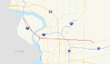
New York State Route 324 (NY 324) is an east–west state highway
located in the western portion
of New York
in the United States. Officially, NY 324 begins at NY 384
in Niagara Falls
and overlaps Interstate 190
(I-190, the Niagara Section of the New York State Thruway
) south to Grand Island
, where it separates from I-190 and continues southward as Grand Island Boulevard. As signed, however, NY 324 begins at the southern end of the official overlap and is contained entirely within Erie County
. At the southern edge of Grand Island, NY 324 joins I-190 to cross over to the mainland, where it runs due east across three towns before reaching its eastern end at a junction with NY 5
in the town of Clarence
.
NY 324 is known by two names along its routing: Grand Island Boulevard on Grand Island and Sheridan Drive in the northern suburb
s of Buffalo
. As the latter, the route serves as a major commercial strip for Tonawanda
, Amherst
, and Clarence
. NY 324, assigned ca. 1933, is one of two routes to occupy part of Sheridan Drive; the other is New York State Route 325, which follows the westernmost 1.42 miles (2.29 km) of the street. NY 324 once extended northwest to downtown Niagara Falls; however, it was truncated to its current western terminus ca. 1962.
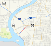
(NYSDOT), NY 324 begins at NY 384
in eastern Niagara Falls
. NY 324 heads south, overlapping with I-190
(the Niagara Section of the New York State Thruway
) across the North Grand Island Bridge
to Grand Island
, where it leaves the expressway at exit 20. However, as signed, NY 324 begins at the north end of Grand Island, where it splits off from the Interstate Highway as Grand Island Boulevard. South of exit 20, the official and signed routings are identical.
Maintenance of the route is split between NYSDOT, the New York State Thruway Authority (NYSTA), and Erie County
. All but the northernmost 0.02 mile (0.0321868 km) of the portion of the route that overlaps with I-190 is maintained by NYSTA. The two county-maintained sections extend from exit 20B to Grand Island Boulevard on Grand Island and from exit 15 to Grand Island Boulevard in Tonawanda
, where NY 324 utilizes small portions of the county-owned Long Road and Kenmore Avenue, respectively. The remainder of NY 324 is maintained by NYSDOT.
 From I-190 exit 20, NY 324 runs in a more southeasterly direction, serving as the main commercial strip on Grand Island, before it overlaps I-190 in order to cross the Niagara River
. It parts company with the Interstate Highway on the other side of the river at exit 15, where it turns north to parallel I-190 on Kenmore Avenue. After 250 yards (229 m), it veers east onto Tonawanda's portion of Grand Island Boulevard for 0.5 mile (0.80467 km) to a junction with Sheridan Drive. The latter carries NY 325, a 1.42 miles (2.29 km) route that begins at NY 266
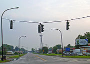
on the banks of the Niagara and passes through a commercial and industrial area of the town of Tonawanda. NY 324 takes on the Sheridan Drive name here and assumes a more due easterly course across northern Erie County. Though the street is signed as a state highway on both NY 324 and NY 325, most residents simply refer to this road by its local name.
Through much of this portion, the road is divided, with a tree-lined median
strip. Businesses, both local and national, line both sides of the road and traffic is heavy. It crosses some other major strips such as Niagara Falls Boulevard (U.S. Route 62
or US 62), a major contributor to traffic on Sheridan due to the proximity of the Boulevard Mall
, and Millersport Highway (NY 263
), which feeds the Amherst campus of the University at Buffalo
.
 In Amherst
it meets the Youngmann Expressway (I-290
) where NY 240
(Harlem Road), reaches its northern end. Past the Youngmann development abates, green returns to the roadside and the median ends, although the road remains four-lane and high-volume. There is another pocket of development around the Wegmans supermarket north of Williamsville
, which has seen some rapid growth in the last few years.
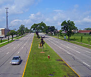
NY 324 crosses its last major route, Transit Road (NY 78
), on an overpass just north of the once-thriving Eastern Hills Mall
, which had been the premier mall in the Buffalo area until it began losing tenants and customers to the larger Walden Galleria
in Cheektowaga.
 Beyond Transit, the road is still four-lane but primarily residential as it enters the Town of Clarence
. After Harris Hill Road, the highway bends to the southeast once again for a final mile into its eastern end at Main Street (NY 5). This last section was widened from two lanes to four in the mid-1990s, and has seen some development but still remains lightly trafficked most of the day.
 When NY 324 was assigned ca. 1933, it began at NY 384
(River Road; now NY 266
) in the town of Tonawanda
and followed Sheridan Drive eastward to NY 5
in the town of Clarence
. By 1935, what is now NY 324 between Niagara Falls
and Tonawanda via Grand Island
was designated as NY 325. NY 324 was extended northward to NY 384
in Niagara Falls ca. 1937, supplanting the entirety of NY 325. The NY 325 designation was reassigned to the short piece of Sheridan Drive not designated as NY 324. The route was extended one final time by 1948 to follow NY 384 westward from the North Grand Island Bridge
into downtown Niagara Falls.
NY 324 remained unchanged until ca. 1962 when the overlap with NY 384 was removed. Although the overlap with the new I-190
on the North Grand Island Bridge was also removed from maps during the same period, and is no longer signed, this overlap was never officially removed from either NYSDOT
's description of the route or the annual NYSDOT Traffic Data Report.
State highway
State highway, state road or state route can refer to one of three related concepts, two of them related to a state or provincial government in a country that is divided into states or provinces :#A...
located in the western portion
Western New York
Western New York is the westernmost region of the state of New York. It includes the cities of Buffalo, Rochester, Niagara Falls, the surrounding suburbs, as well as the outlying rural areas of the Great Lakes lowlands, the Genesee Valley, and the Southern Tier. Some historians, scholars and others...
of New York
New York
New York is a state in the Northeastern region of the United States. It is the nation's third most populous state. New York is bordered by New Jersey and Pennsylvania to the south, and by Connecticut, Massachusetts and Vermont to the east...
in the United States. Officially, NY 324 begins at NY 384
New York State Route 384
New York State Route 384 is a state highway in Western New York in the United States. It is a north–south route extending from the city of Buffalo, Erie County to the city of Niagara Falls, Niagara County, and is one of several routes directly connecting the two cities. The southern terminus...
in Niagara Falls
Niagara Falls, New York
Niagara Falls is a city in Niagara County, New York, United States. As of the 2010 census, the city had a total population of 50,193, down from the 55,593 recorded in the 2000 census. It is across the Niagara River from Niagara Falls, Ontario , both named after the famed Niagara Falls which they...
and overlaps Interstate 190
Interstate 190 (New York)
Interstate 190 runs 28.34 miles from Interstate 90 near Buffalo, New York to Lewiston, New York via Niagara Falls. Parts of this highway were built on the former rights-of-way of the Lehigh Valley Railroad and the Erie Canal. It is referred to by locals as The One-Ninety...
(I-190, the Niagara Section of the New York State Thruway
New York State Thruway
The New York State Thruway is a system of limited-access highways located within the state of New York in the United States. The system, known officially as the Governor Thomas E. Dewey Thruway for former New York Governor Thomas E. Dewey, is operated by the New York State Thruway Authority and...
) south to Grand Island
Grand Island, New York
Grand Island is a town and an island in Erie County, New York, USA. As of the 2010 census, the town population is 20,374. This represents an increase of 9.41% from the 2000 census figure . The current town name derives from the French name La Grande Île, as Grand Island is the largest island in...
, where it separates from I-190 and continues southward as Grand Island Boulevard. As signed, however, NY 324 begins at the southern end of the official overlap and is contained entirely within Erie County
Erie County, New York
Erie County is a county located in the U.S. state of New York. As of the 2010 census, the population was 919,040. The county seat is Buffalo. The county's name comes from Lake Erie, which in turn comes from the Erie tribe of American Indians who lived south and east of the lake before 1654.Erie...
. At the southern edge of Grand Island, NY 324 joins I-190 to cross over to the mainland, where it runs due east across three towns before reaching its eastern end at a junction with NY 5
New York State Route 5
New York State Route 5 is a state highway that extends for across the state of New York in the United States. It begins at the Pennsylvania state line in the Chautauqua County town of Ripley and passes through Buffalo, Syracuse, Utica, Schenectady, and several other smaller cities and...
in the town of Clarence
Clarence, New York
Clarence is a town located in the northeastern part of Erie County, New York, United States. The population was 30,673 according to the 2010 census. This represents an increase of 17.42% from the 2000 census figure . Clarence is also the name of a postal district in the south part of the town...
.
NY 324 is known by two names along its routing: Grand Island Boulevard on Grand Island and Sheridan Drive in the northern suburb
Suburb
The word suburb mostly refers to a residential area, either existing as part of a city or as a separate residential community within commuting distance of a city . Some suburbs have a degree of administrative autonomy, and most have lower population density than inner city neighborhoods...
s of Buffalo
Buffalo, New York
Buffalo is the second most populous city in the state of New York, after New York City. Located in Western New York on the eastern shores of Lake Erie and at the head of the Niagara River across from Fort Erie, Ontario, Buffalo is the seat of Erie County and the principal city of the...
. As the latter, the route serves as a major commercial strip for Tonawanda
Tonawanda (town), New York
Tonawanda is a town in Erie County, New York, United States. As of the 2000 census, the town had a population of 78,155. The town is at the north border of the county and is the northern suburb of Buffalo...
, Amherst
Amherst, New York
Amherst is a town in Erie County, New York, United States. As of the 2010 census, the town had a total population of 122,366. This represents an increase of 5.0% from the 2000 census. The town is named for Jeffrey Amherst, a British Army officer of the colonial period...
, and Clarence
Clarence, New York
Clarence is a town located in the northeastern part of Erie County, New York, United States. The population was 30,673 according to the 2010 census. This represents an increase of 17.42% from the 2000 census figure . Clarence is also the name of a postal district in the south part of the town...
. NY 324, assigned ca. 1933, is one of two routes to occupy part of Sheridan Drive; the other is New York State Route 325, which follows the westernmost 1.42 miles (2.29 km) of the street. NY 324 once extended northwest to downtown Niagara Falls; however, it was truncated to its current western terminus ca. 1962.
Route description
According to the New York State Department of TransportationNew York State Department of Transportation
The New York State Department of Transportation is responsible for the development and operation of highways, railroads, mass transit systems, ports, waterways and aviation facilities in the U.S...
(NYSDOT), NY 324 begins at NY 384
New York State Route 384
New York State Route 384 is a state highway in Western New York in the United States. It is a north–south route extending from the city of Buffalo, Erie County to the city of Niagara Falls, Niagara County, and is one of several routes directly connecting the two cities. The southern terminus...
in eastern Niagara Falls
Niagara Falls, New York
Niagara Falls is a city in Niagara County, New York, United States. As of the 2010 census, the city had a total population of 50,193, down from the 55,593 recorded in the 2000 census. It is across the Niagara River from Niagara Falls, Ontario , both named after the famed Niagara Falls which they...
. NY 324 heads south, overlapping with I-190
Interstate 190 (New York)
Interstate 190 runs 28.34 miles from Interstate 90 near Buffalo, New York to Lewiston, New York via Niagara Falls. Parts of this highway were built on the former rights-of-way of the Lehigh Valley Railroad and the Erie Canal. It is referred to by locals as The One-Ninety...
(the Niagara Section of the New York State Thruway
New York State Thruway
The New York State Thruway is a system of limited-access highways located within the state of New York in the United States. The system, known officially as the Governor Thomas E. Dewey Thruway for former New York Governor Thomas E. Dewey, is operated by the New York State Thruway Authority and...
) across the North Grand Island Bridge
North Grand Island Bridge
The North Grand Island Bridge carries Interstate 190 across the Niagara River between Grand Island, New York and Niagara Falls, New York. The toll plaza are found on the Grand Island, New York side of the bridge....
to Grand Island
Grand Island, New York
Grand Island is a town and an island in Erie County, New York, USA. As of the 2010 census, the town population is 20,374. This represents an increase of 9.41% from the 2000 census figure . The current town name derives from the French name La Grande Île, as Grand Island is the largest island in...
, where it leaves the expressway at exit 20. However, as signed, NY 324 begins at the north end of Grand Island, where it splits off from the Interstate Highway as Grand Island Boulevard. South of exit 20, the official and signed routings are identical.
Maintenance of the route is split between NYSDOT, the New York State Thruway Authority (NYSTA), and Erie County
Erie County, New York
Erie County is a county located in the U.S. state of New York. As of the 2010 census, the population was 919,040. The county seat is Buffalo. The county's name comes from Lake Erie, which in turn comes from the Erie tribe of American Indians who lived south and east of the lake before 1654.Erie...
. All but the northernmost 0.02 mile (0.0321868 km) of the portion of the route that overlaps with I-190 is maintained by NYSTA. The two county-maintained sections extend from exit 20B to Grand Island Boulevard on Grand Island and from exit 15 to Grand Island Boulevard in Tonawanda
Tonawanda (town), New York
Tonawanda is a town in Erie County, New York, United States. As of the 2000 census, the town had a population of 78,155. The town is at the north border of the county and is the northern suburb of Buffalo...
, where NY 324 utilizes small portions of the county-owned Long Road and Kenmore Avenue, respectively. The remainder of NY 324 is maintained by NYSDOT.
Niagara River
The Niagara River flows north from Lake Erie to Lake Ontario. It forms part of the border between the Province of Ontario in Canada and New York State in the United States. There are differing theories as to the origin of the name of the river...
. It parts company with the Interstate Highway on the other side of the river at exit 15, where it turns north to parallel I-190 on Kenmore Avenue. After 250 yards (229 m), it veers east onto Tonawanda's portion of Grand Island Boulevard for 0.5 mile (0.80467 km) to a junction with Sheridan Drive. The latter carries NY 325, a 1.42 miles (2.29 km) route that begins at NY 266
New York State Route 266
New York State Route 266 is a state highway in Erie County, New York, in the United States. It runs along the Niagara River from the city of Buffalo to the city of North Tonawanda. The southern terminus of the route is at the ramps leading to Interstate 190 exit 8 in Buffalo...
on the banks of the Niagara and passes through a commercial and industrial area of the town of Tonawanda. NY 324 takes on the Sheridan Drive name here and assumes a more due easterly course across northern Erie County. Though the street is signed as a state highway on both NY 324 and NY 325, most residents simply refer to this road by its local name.
Through much of this portion, the road is divided, with a tree-lined median
Median
In probability theory and statistics, a median is described as the numerical value separating the higher half of a sample, a population, or a probability distribution, from the lower half. The median of a finite list of numbers can be found by arranging all the observations from lowest value to...
strip. Businesses, both local and national, line both sides of the road and traffic is heavy. It crosses some other major strips such as Niagara Falls Boulevard (U.S. Route 62
U.S. Route 62 in New York
U.S. Route 62 is a part of the U.S. Highway System that runs from the United States – Mexico border at El Paso, Texas, to Niagara Falls, New York. In the U.S. state of New York, US 62 extends from the New York – Pennsylvania border south of Jamestown to an intersection with...
or US 62), a major contributor to traffic on Sheridan due to the proximity of the Boulevard Mall
Boulevard Mall
Boulevard Mall, which opened in 1962, is a shopping mall located north of City of Buffalo at the western edge of the Town of Amherst in Erie County, New York, USA. The name derives from its location on Niagara Falls Boulevard , which divides Amherst from the Town of Tonawanda...
, and Millersport Highway (NY 263
New York State Route 263
New York State Route 263 is a state highway located entirely within the town of Amherst in Erie County, New York, in the United States. It extends from just north of the northeast corner of the city of Buffalo in a roughly northeast direction almost straight to just south of the north county...
), which feeds the Amherst campus of the University at Buffalo
University at Buffalo, The State University of New York
University at Buffalo, The State University of New York, also commonly known as the University at Buffalo or UB, is a public research university and a "University Center" in the State University of New York system. The university was founded by Millard Fillmore in 1846. UB has multiple campuses...
.
Amherst, New York
Amherst is a town in Erie County, New York, United States. As of the 2010 census, the town had a total population of 122,366. This represents an increase of 5.0% from the 2000 census. The town is named for Jeffrey Amherst, a British Army officer of the colonial period...
it meets the Youngmann Expressway (I-290
Interstate 290 (New York)
Interstate 290 runs for near Buffalo, New York from I-90 to I-190. It connects Buffalo with its northern suburbs of Amherst and Tonawanda, and provides a route to Niagara Falls that bypasses the city of Buffalo. I-290 also connects to Interstate 990, and through this connection,...
) where NY 240
New York State Route 240
New York State Route 240 is a state highway in western New York in the United States. The southern terminus of the route is at an intersection with NY 242 in the Ellicottville community of Ashford in northern Cattaraugus County. Its northern terminus is at a junction with NY 324...
(Harlem Road), reaches its northern end. Past the Youngmann development abates, green returns to the roadside and the median ends, although the road remains four-lane and high-volume. There is another pocket of development around the Wegmans supermarket north of Williamsville
Williamsville, New York
Williamsville is a village in Erie County, New York in the United States. The population was 5,573 at the 2000 census. The village is named after Jonas Williams, an early settler...
, which has seen some rapid growth in the last few years.
NY 324 crosses its last major route, Transit Road (NY 78
New York State Route 78
New York State Route 78 , most commonly known as Transit Road, is a state highway in Western New York, USA. While it is signed north–south, the lower portion runs in an east–west direction across Wyoming County, from its beginning north of the Village of Gainesville.NY 78 is...
), on an overpass just north of the once-thriving Eastern Hills Mall
Eastern Hills Mall
Eastern Hills Mall, which opened in 1971, is a shopping mall located at the west border of the Town of Clarence in Erie County, New York, USA. It lies on Transit Road , which divides Clarence from the Town of Amherst...
, which had been the premier mall in the Buffalo area until it began losing tenants and customers to the larger Walden Galleria
Walden Galleria
Walden Galleria is an enclosed shopping mall located in the town of Cheektowaga, New York. Walden Galleria comprises more than of retail space, with 250 stores on two levels, including a food court and a movie theater. Anchor stores include Best Buy, Dick's Sporting Goods, DSW Shoe Warehouse,...
in Cheektowaga.
Clarence, New York
Clarence is a town located in the northeastern part of Erie County, New York, United States. The population was 30,673 according to the 2010 census. This represents an increase of 17.42% from the 2000 census figure . Clarence is also the name of a postal district in the south part of the town...
. After Harris Hill Road, the highway bends to the southeast once again for a final mile into its eastern end at Main Street (NY 5). This last section was widened from two lanes to four in the mid-1990s, and has seen some development but still remains lightly trafficked most of the day.
History
New York State Route 384
New York State Route 384 is a state highway in Western New York in the United States. It is a north–south route extending from the city of Buffalo, Erie County to the city of Niagara Falls, Niagara County, and is one of several routes directly connecting the two cities. The southern terminus...
(River Road; now NY 266
New York State Route 266
New York State Route 266 is a state highway in Erie County, New York, in the United States. It runs along the Niagara River from the city of Buffalo to the city of North Tonawanda. The southern terminus of the route is at the ramps leading to Interstate 190 exit 8 in Buffalo...
) in the town of Tonawanda
Tonawanda (town), New York
Tonawanda is a town in Erie County, New York, United States. As of the 2000 census, the town had a population of 78,155. The town is at the north border of the county and is the northern suburb of Buffalo...
and followed Sheridan Drive eastward to NY 5
New York State Route 5
New York State Route 5 is a state highway that extends for across the state of New York in the United States. It begins at the Pennsylvania state line in the Chautauqua County town of Ripley and passes through Buffalo, Syracuse, Utica, Schenectady, and several other smaller cities and...
in the town of Clarence
Clarence, New York
Clarence is a town located in the northeastern part of Erie County, New York, United States. The population was 30,673 according to the 2010 census. This represents an increase of 17.42% from the 2000 census figure . Clarence is also the name of a postal district in the south part of the town...
. By 1935, what is now NY 324 between Niagara Falls
Niagara Falls, New York
Niagara Falls is a city in Niagara County, New York, United States. As of the 2010 census, the city had a total population of 50,193, down from the 55,593 recorded in the 2000 census. It is across the Niagara River from Niagara Falls, Ontario , both named after the famed Niagara Falls which they...
and Tonawanda via Grand Island
Grand Island, New York
Grand Island is a town and an island in Erie County, New York, USA. As of the 2010 census, the town population is 20,374. This represents an increase of 9.41% from the 2000 census figure . The current town name derives from the French name La Grande Île, as Grand Island is the largest island in...
was designated as NY 325. NY 324 was extended northward to NY 384
New York State Route 384
New York State Route 384 is a state highway in Western New York in the United States. It is a north–south route extending from the city of Buffalo, Erie County to the city of Niagara Falls, Niagara County, and is one of several routes directly connecting the two cities. The southern terminus...
in Niagara Falls ca. 1937, supplanting the entirety of NY 325. The NY 325 designation was reassigned to the short piece of Sheridan Drive not designated as NY 324. The route was extended one final time by 1948 to follow NY 384 westward from the North Grand Island Bridge
North Grand Island Bridge
The North Grand Island Bridge carries Interstate 190 across the Niagara River between Grand Island, New York and Niagara Falls, New York. The toll plaza are found on the Grand Island, New York side of the bridge....
into downtown Niagara Falls.
NY 324 remained unchanged until ca. 1962 when the overlap with NY 384 was removed. Although the overlap with the new I-190
Interstate 190 (New York)
Interstate 190 runs 28.34 miles from Interstate 90 near Buffalo, New York to Lewiston, New York via Niagara Falls. Parts of this highway were built on the former rights-of-way of the Lehigh Valley Railroad and the Erie Canal. It is referred to by locals as The One-Ninety...
on the North Grand Island Bridge was also removed from maps during the same period, and is no longer signed, this overlap was never officially removed from either NYSDOT
New York State Department of Transportation
The New York State Department of Transportation is responsible for the development and operation of highways, railroads, mass transit systems, ports, waterways and aviation facilities in the U.S...
's description of the route or the annual NYSDOT Traffic Data Report.