

New York State Route 211
Encyclopedia
New York State Route 211 (NY 211) is a state highway
located entirely within Orange County, New York
, in the United States
. The western terminus is at the intersection with US 209 located in Cuddebackville, and the eastern terminus is located at Montgomery
at NY 17K
, where it becomes the main thoroughfare.
Through Middletown
, it briefly becomes a divided highway with a maximum of five lanes in each direction (a total of ten lanes). It was also through Middletown that the famed "Miracle Mile" was born, which was the beginning of the shopping center frenzy that saw many businesses move from downtown areas of Middletown to the Route 211 Shopping Corridor.
Only in Middletown does the first sign along NY 211 with a directional banner appear, when headed eastward. At that point, the road is running more to the northwest.
y lowlands. On the way up it makes its first crossing of the tracks of the Metro North
, Port Jervis Line
, also used by Norfolk Southern for freight. These will reappear at different times later along the route.
Looming ahead is a low but still formidable section of the Shawangunk Ridge
, and after leaving the river's flood plain the highway immediately curves and begins to climb the ridge, here mostly wooded and undeveloped. There are some scenic cliff
s ahead, and the road crests at 897 feet (273 m) above sea level just before reaching the village of Otisville
.
 Through the small rural village the road continues to descend, crossing the Port Jervis line again just next to the train station
. In the countryside once again, passing through more open but still rolling and picturesque farmlands, it curves back and forth through Howells, gradually seeing more and more homes by the roadside, until it narrows and straightens out at the Middletown
city limit.
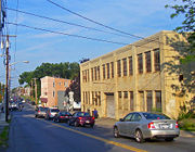 Route 211 enters the city as Monhagen Avenue for a mile, until it turns east onto West Main Street and merges with NY 17M
. West Main branches to the southeast, the street name of the combined routes becoming Wickham Avenue, where these two follow a straight course to North Sreet, where NY 17M leaves to the northwest and NY 211 continues ahead east. It crosses a single track railway, which is the last vestiges of the New York, Ontario, and Western Railroad
. The former headquarters/Middletown station of the O&W, heavily damaged by fire in 2004, sit next to the tracks.
There are no green New York State Department of Transportation
reference markers at all along the road in Middletown (where the city is responsible for maintenance), although the road itself is amply signed.
, with maximum traffic and width coming as the road passes the Wal-Mart
Supercenter at the site of the Orange Plaza, crosses the Port Jervis line for the third and last time and then has its interchange with NY 17
. On the opposite side are Gander Mountain
and Sam's Club
, and the entrance to the county's largest shopping mall, the Galleria at Crystal Run
.
Beyond that, NY 211 remains divided for 0.6 mile (1 km), and then four lanes for another 0.5 mile (900 m) until it is back to two lanes going through Scotchtown
, and development abates. The Port Jervis line briefly comes aside the highway as it nears the wooded tracts of Highland Lakes State Park
, until leaving NY 211 behind for good. The Long Path
hiking trail crosses the road at a trailer park entrance opposite Hidden Drive.
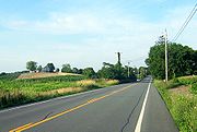 The countryside along the highway is once again rural, but here NY 211 is straight and flat as it enters the lowlands around the Wallkill River
. Interstate 84
runs closely parallel to the road through this section and can be seen at several points.
After crossing the river, Orange County Airport
appears on the west side of the road. The northern end of NY 416
terminates on NY 211 just outside the village of Montgomery
, meeting at an angle.
 The Village of Montgomery has a posted speed limit of 30mph starting at the border near Chandler Lane. The open fields on both sides of the road at the village limit transition to residential sections. The road passes Montgomery Elementary School
on the east side of the road. NY 211 becomes Union Street, one the village's two major streets, passing through the larger
of the village's two historic districts
. At the end of downtown, NY 211 ends at a traffic light
with Main Street, NY 17K
.
) in Middletown
to Montgomery
was originally designated as part of NY 8 when the first set of posted routes in New York
were assigned in 1924. NY 8 continued south from Middletown to the New Jersey
state line at Unionville on modern NY 284
and east from Montgomery to Newburgh
on current NY 17K
. In the 1930 renumbering of state highways in New York, the portion of NY 8 southwest of Montgomery was renumbered to NY 84 while a previously unnumbered highway between Cuddebackville and NY 17
(modern NY 17K) in Middletown was designated as NY 211. The NY 84 designation was removed in the mid-1960s to eliminate numerical duplication with the under-construction Interstate 84
. Its former routing from Middletown to Montgomery became an eastward extension of NY 211.
The westernmost portion, according to a historical marker in Cuddebackville, follows the old Mount Hope and Lumberland Turnpike, built during the War of 1812
.
State highway
State highway, state road or state route can refer to one of three related concepts, two of them related to a state or provincial government in a country that is divided into states or provinces :#A...
located entirely within Orange County, New York
Orange County, New York
Orange County is a county located in the U.S. state of New York. It is part of the Poughkeepsie–Newburgh–Middletown, NY Metropolitan Statistical Area and is located at the northern reaches of the New York metropolitan area. The county sits in the state's scenic Mid-Hudson Region of the Hudson Valley...
, in the United States
United States
The United States of America is a federal constitutional republic comprising fifty states and a federal district...
. The western terminus is at the intersection with US 209 located in Cuddebackville, and the eastern terminus is located at Montgomery
Montgomery (village), New York
Montgomery is a village located in Orange County, New York, United States, 60 miles northwest of New York City, and 90 miles southwest of Albany. The population was 3,636 at the 2000 census...
at NY 17K
New York State Route 17K
New York State Route 17K is an east–west state highway located within Orange County, New York, in the United States. It extends for from an intersection with County Route 76 east of Bloomingburg to a junction with U.S. Route 9W midway across the city of Newburgh...
, where it becomes the main thoroughfare.
Through Middletown
Middletown, Orange County, New York
Middletown is a city in Orange County, New York, United States. It lies in New York's Hudson Valley region, near the Wallkill River and the foothills of the Shawangunk Mountains. Middletown is situated between Port Jervis and Newburgh, New York. The city's population was 25,388 at the 2000 census...
, it briefly becomes a divided highway with a maximum of five lanes in each direction (a total of ten lanes). It was also through Middletown that the famed "Miracle Mile" was born, which was the beginning of the shopping center frenzy that saw many businesses move from downtown areas of Middletown to the Route 211 Shopping Corridor.
Only in Middletown does the first sign along NY 211 with a directional banner appear, when headed eastward. At that point, the road is running more to the northwest.
Route description
Route 211 has three distinct segments, reflected on the reference markers along the highway: west of Middletown, the city of Middletown, and east of Middletown. All run through distinctly different terrain.West of Middletown
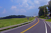
The first 10 miles (16 km) are characterized by rugged and scenic countryside. They begin at the junction with 209. NY 211 at first heads straight east-southeast, crossing the limited downtown section of Cuddebackville and then the Basher Kill and its swampSwamp
A swamp is a wetland with some flooding of large areas of land by shallow bodies of water. A swamp generally has a large number of hammocks, or dry-land protrusions, covered by aquatic vegetation, or vegetation that tolerates periodical inundation. The two main types of swamp are "true" or swamp...
y lowlands. On the way up it makes its first crossing of the tracks of the Metro North
Metro north
Metro North can refer to either of* Metro-North Railroad, a commuter railroad serving parts of New York and Connecticut in the United States* Dublin Metro#Metro North, a branch of the proposed Dublin Metro, in Dublin, Ireland...
, Port Jervis Line
Port Jervis Line (Metro-North)
The Metro-North Railroad Port Jervis Line is a predominantly single-track commuter rail line running from Suffern, New York to Port Jervis. At Suffern, the line continues south into New Jersey as NJ Transit's Main Line....
, also used by Norfolk Southern for freight. These will reappear at different times later along the route.
Looming ahead is a low but still formidable section of the Shawangunk Ridge
Shawangunk Ridge
The Shawangunk Ridge , also known as the Shawangunk Mountains or The Gunks, is a ridge of bedrock in Ulster County, Sullivan County and Orange County in the state of New York, extending from the northernmost point of New Jersey to the Catskill Mountains.The ridgetop, which widens considerably at...
, and after leaving the river's flood plain the highway immediately curves and begins to climb the ridge, here mostly wooded and undeveloped. There are some scenic cliff
Cliff
In geography and geology, a cliff is a significant vertical, or near vertical, rock exposure. Cliffs are formed as erosion landforms due to the processes of erosion and weathering that produce them. Cliffs are common on coasts, in mountainous areas, escarpments and along rivers. Cliffs are usually...
s ahead, and the road crests at 897 feet (273 m) above sea level just before reaching the village of Otisville
Otisville, New York
Otisville is a village in Orange County, New York, United States. The population was 989 at the 2000 census. It is part of the Poughkeepsie–Newburgh–Middletown, NY Metropolitan Statistical Area as well as the larger New York–Newark–Bridgeport, NY-NJ-CT-PA Combined...
.
Otisville (Metro-North station)
The Otisville Metro-North station serves the residents of that community and the town of Mount Hope in Orange County, New York. Trains depart regularly for Hoboken, 81.6 miles away; travel time is about an hour and 50 minutes....
. In the countryside once again, passing through more open but still rolling and picturesque farmlands, it curves back and forth through Howells, gradually seeing more and more homes by the roadside, until it narrows and straightens out at the Middletown
Middletown, Orange County, New York
Middletown is a city in Orange County, New York, United States. It lies in New York's Hudson Valley region, near the Wallkill River and the foothills of the Shawangunk Mountains. Middletown is situated between Port Jervis and Newburgh, New York. The city's population was 25,388 at the 2000 census...
city limit.
City of Middletown
New York State Route 17M
New York State Route 17M is an east–west state highway in Orange County, New York, in the United States. It extends for from west of the city of Middletown to what is currently the north–south section of NY 17 just southeast of the village of Harriman...
. West Main branches to the southeast, the street name of the combined routes becoming Wickham Avenue, where these two follow a straight course to North Sreet, where NY 17M leaves to the northwest and NY 211 continues ahead east. It crosses a single track railway, which is the last vestiges of the New York, Ontario, and Western Railroad
New York, Ontario and Western Railway
The New York, Ontario and Western Railway, more commonly known as the O&W or NYO&W, was a regional railroad with origins in 1868, lasting until March 29, 1957 when it was ordered liquidated by a US bankruptcy judge. The O&W holds the distinction of being the first major U.S...
. The former headquarters/Middletown station of the O&W, heavily damaged by fire in 2004, sit next to the tracks.
There are no green New York State Department of Transportation
New York State Department of Transportation
The New York State Department of Transportation is responsible for the development and operation of highways, railroads, mass transit systems, ports, waterways and aviation facilities in the U.S...
reference markers at all along the road in Middletown (where the city is responsible for maintenance), although the road itself is amply signed.
East of Middletown
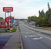
Upon leaving the city, NY 211 expands to four lanes and becomes a major shopping strip, with many different retailers and restaurants on both sides. This continues to build through almost two miles (3 km) of the Town of WallkillWallkill, Orange County, New York
Wallkill is a town in Orange County, New York, United States. The population was 24,659 at the 2000 census.The Town of Wallkill is centrally located in the county. Interstate 84 crosses New York State Route 17 in the southern part of the town. U.S...
, with maximum traffic and width coming as the road passes the Wal-Mart
Wal-Mart
Wal-Mart Stores, Inc. , branded as Walmart since 2008 and Wal-Mart before then, is an American public multinational corporation that runs chains of large discount department stores and warehouse stores. The company is the world's 18th largest public corporation, according to the Forbes Global 2000...
Supercenter at the site of the Orange Plaza, crosses the Port Jervis line for the third and last time and then has its interchange with NY 17
New York State Route 17
New York State Route 17 is a state highway that extends for through the Southern Tier and Downstate regions of New York in the United States...
. On the opposite side are Gander Mountain
Gander Mountain
Gander Mountain, headquartered in St. Paul, Minnesota, is a retail network of stores for hunting, fishing, camping, marine, and other outdoor recreation products and services...
and Sam's Club
Sam's Club
Sam's Club is a chain of membership-only retail warehouse clubs owned and operated by Wal-Mart Stores, Inc., founded in 1983 and named after Wal-Mart founder Sam Walton. , the Sam's Club chain serves more than 47 million U.S. members...
, and the entrance to the county's largest shopping mall, the Galleria at Crystal Run
Galleria at Crystal Run
The Galleria at Crystal Run is a shopping mall in Wallkill, New York and is the second largest mall in New York's Hudson Valley region. The mall, which opened in 1992, has an area of 1,100,000 square feet with two floors and 250 shops and restaurants as well as a 16-screen AMC Theatres .The mall...
.
Beyond that, NY 211 remains divided for 0.6 mile (1 km), and then four lanes for another 0.5 mile (900 m) until it is back to two lanes going through Scotchtown
Scotchtown, New York
Scotchtown is a hamlet in Orange County, New York, United States. The population was 8,954 at the 2000 census. It has the ZIP Code 10941.Scotchtown is in the Town of Wallkill, east of the City of Middletown...
, and development abates. The Port Jervis line briefly comes aside the highway as it nears the wooded tracts of Highland Lakes State Park
Highland Lakes State Park
Highland Lakes State Park is a state park in the State of New York, USA. The park is located in Orange County north of New York City.The park is west of Middletown on Route 211.The park offers hiking, fishing and a bridle path...
, until leaving NY 211 behind for good. The Long Path
Long Path
The Long Path is a long-distance hiking trail beginning at the George Washington Bridge in Fort Lee, New Jersey and currently ending at Altamont, New York, in the Albany area...
hiking trail crosses the road at a trailer park entrance opposite Hidden Drive.
Wallkill River
The Wallkill River, a tributary of the Hudson, drains Lake Mohawk in Sparta, New Jersey, flowing from there generally northeasterly to Rondout Creek in New York, near Rosendale, with the combined flows reaching the Hudson at Kingston....
. Interstate 84
Interstate 84 (east)
Interstate 84 is an Interstate Highway extending from Dunmore, Pennsylvania at an interchange with Interstate 81 to Sturbridge, Massachusetts, at an interchange with the Massachusetts Turnpike . I-84 has mile-log junction numbering in Pennsylvania; otherwise, exit numbers are roughly sequential...
runs closely parallel to the road through this section and can be seen at several points.
After crossing the river, Orange County Airport
Orange County Airport (New York)
New York’s Orange County Airport is an untowered general aviation airport located 1 mile southwest of village of Montgomery, in the Town of Montgomery, New York...
appears on the west side of the road. The northern end of NY 416
New York State Route 416
New York State Route 416 is a state highway located entirely within the towns of Hamptonburgh and Montgomery in Orange County, New York, in the United States. It does not intersect any other state routes besides those at its termini, nor pass through any settlements...
terminates on NY 211 just outside the village of Montgomery
Montgomery (village), New York
Montgomery is a village located in Orange County, New York, United States, 60 miles northwest of New York City, and 90 miles southwest of Albany. The population was 3,636 at the 2000 census...
, meeting at an angle.
Montgomery Elementary School
Montgomery Elementary School is located on Union Street in the village of Montgomery, New York, United States. It educates children from grades kindergarten through 5 in the Valley Central School District, most of them residents of the village or nearby sections of the Town of Montgomery.It is a...
on the east side of the road. NY 211 becomes Union Street, one the village's two major streets, passing through the larger
Union Street-Academy Hill Historic District
The Union Street-Academy Hill Historic District makes up most of downtown Montgomery, New York, United States. It abuts the smaller Bridge Street Historic District to the northwest...
of the village's two historic districts
Historic district (United States)
In the United States, a historic district is a group of buildings, properties, or sites that have been designated by one of several entities on different levels as historically or architecturally significant. Buildings, structures, objects and sites within a historic district are normally divided...
. At the end of downtown, NY 211 ends at a traffic light
Traffic light
Traffic lights, which may also be known as stoplights, traffic lamps, traffic signals, signal lights, robots or semaphore, are signalling devices positioned at road intersections, pedestrian crossings and other locations to control competing flows of traffic...
with Main Street, NY 17K
New York State Route 17K
New York State Route 17K is an east–west state highway located within Orange County, New York, in the United States. It extends for from an intersection with County Route 76 east of Bloomingburg to a junction with U.S. Route 9W midway across the city of Newburgh...
.
History
The section of what is now NY 211 from North Street (now NY 17MNew York State Route 17M
New York State Route 17M is an east–west state highway in Orange County, New York, in the United States. It extends for from west of the city of Middletown to what is currently the north–south section of NY 17 just southeast of the village of Harriman...
) in Middletown
Middletown, Orange County, New York
Middletown is a city in Orange County, New York, United States. It lies in New York's Hudson Valley region, near the Wallkill River and the foothills of the Shawangunk Mountains. Middletown is situated between Port Jervis and Newburgh, New York. The city's population was 25,388 at the 2000 census...
to Montgomery
Montgomery (village), New York
Montgomery is a village located in Orange County, New York, United States, 60 miles northwest of New York City, and 90 miles southwest of Albany. The population was 3,636 at the 2000 census...
was originally designated as part of NY 8 when the first set of posted routes in New York
New York
New York is a state in the Northeastern region of the United States. It is the nation's third most populous state. New York is bordered by New Jersey and Pennsylvania to the south, and by Connecticut, Massachusetts and Vermont to the east...
were assigned in 1924. NY 8 continued south from Middletown to the New Jersey
New Jersey
New Jersey is a state in the Northeastern and Middle Atlantic regions of the United States. , its population was 8,791,894. It is bordered on the north and east by the state of New York, on the southeast and south by the Atlantic Ocean, on the west by Pennsylvania and on the southwest by Delaware...
state line at Unionville on modern NY 284
New York State Route 284
New York State Route 284 is a short state highway located entirely in Orange County in New York, United States. It is the continuation of New Jersey Route 284 northbound from the state line at Minisink to U.S. Route 6 in Wawayanda...
and east from Montgomery to Newburgh
Newburgh (city), New York
Newburgh is a city located in Orange County, New York, United States, north of New York City, and south of Albany, on the Hudson River. Newburgh is a principal city of the Poughkeepsie-Newburgh-Middletown metropolitan area, which includes all of Dutchess and Orange counties. The Newburgh area was...
on current NY 17K
New York State Route 17K
New York State Route 17K is an east–west state highway located within Orange County, New York, in the United States. It extends for from an intersection with County Route 76 east of Bloomingburg to a junction with U.S. Route 9W midway across the city of Newburgh...
. In the 1930 renumbering of state highways in New York, the portion of NY 8 southwest of Montgomery was renumbered to NY 84 while a previously unnumbered highway between Cuddebackville and NY 17
New York State Route 17
New York State Route 17 is a state highway that extends for through the Southern Tier and Downstate regions of New York in the United States...
(modern NY 17K) in Middletown was designated as NY 211. The NY 84 designation was removed in the mid-1960s to eliminate numerical duplication with the under-construction Interstate 84
Interstate 84 in New York
Interstate 84 is a part of the Interstate Highway System that runs from Dunmore, Pennsylvania, to Sturbridge, Massachusetts, in the Eastern United States. In New York, I-84 extends from the Pennsylvania state line at Port Jervis to the Connecticut state line east of Brewster...
. Its former routing from Middletown to Montgomery became an eastward extension of NY 211.
The westernmost portion, according to a historical marker in Cuddebackville, follows the old Mount Hope and Lumberland Turnpike, built during the War of 1812
War of 1812
The War of 1812 was a military conflict fought between the forces of the United States of America and those of the British Empire. The Americans declared war in 1812 for several reasons, including trade restrictions because of Britain's ongoing war with France, impressment of American merchant...
.