
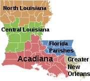
New Orleans metropolitan area
Encyclopedia
New Orleans–Metairie–Kenner, or the Greater New Orleans Region (as it is often called by the Louisiana
Tourism Commission) is a metropolitan area designated by the United States Census
encompassing seven parishes (the Louisiana equivalent of other states' counties) in the state of Louisiana
, centering on the city of New Orleans. As of the July 1, 2008 estimate, the metropolitan statistical area (MSA) had a population of 1.17 million; the combined statistical area (CSA), which adds Washington Parish, had a population of 1.18 million; and the ten-parish area (including Tangipahoa and St. James Parishes) used by GNO, Inc.http://www.gnoinc.org/ (the regional chamber of commerce) had a population of 1.32 million.
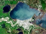
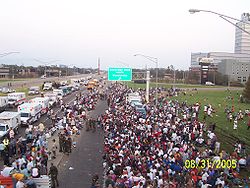
The metropolitan area was hit by Hurricane Katrina
– once a Category 5 but a Category 3 storm at landfall – in August 2005. Within the city of New Orleans proper, multiple breaches and structural failures occurred in the system of levees and floodwalls designed under federal government auspices. The resulting decline in the city's population negatively impacted population numbers for the entire metro area, for which a population of 1.3 million was recorded in the 2000 Census. Most of the decline in population to 1.17 million is accounted for by the decline in population experienced in the city of New Orleans proper (coterminous with Orleans Parish); the Census Bureau estimates that the city's population dropped from 453,728 prior to the storm (July 1, 2005) to 354,850 at the most recent estimate for 2009.
 The New Orleans–Metairie–Bogalusa Combined Statistical Area (CSA) is made up of eight parishes. The statistical area includes one metropolitan area
and one micropolitan area
. As of the 2000 Census, the CSA had a population of 1,360,436 (though a July 1, 2008 estimate placed the population at 1,179,459).
, 37.17% African American, 0.37% Native American, 2.10% Asian
, 0.03% Pacific Islander
, 1.20% from other races, and 1.39% from two or more races. Hispanics or Latinos
of any race were 4.32% of the population.
The median income for a household in the CSA was $37,053, and the median income for a family was $42,860. Males had a median income of $35,659 versus $23,150 for females. The per capita income for the CSA was $17,474.
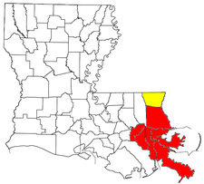
, Orleans (coterminous with the city of New Orleans), Plaquemines
, St. Bernard
, St. Tammany
, St. Charles
, and St. John the Baptist
. The Census Bureau's CSA (combined statistical area) adds Washington
.
The New Orleans region's chamber of commerce, GNO, Inc.http://www.gnoinc.org/ (formerly Metrovision) includes the eight parishes of the Census Bureau's CSA plus St. James and Tangipahoa
. This wider 10-parish region had a population of 1.32 million as of July 1, 2008.
The Louisiana state legislature created a commission, the Regional Planning Commission, to be responsible for the planning and development of the New Orleans metropolitan area. The parishes covered by the commission are: Jefferson
, Orleans, Plaquemines
, St. Bernard
, and St. Tammany
. Additionally, St. Charles
and St. John the Baptist
are associate members of the Regional Planning Commission.
The Center for Cultural and Eco-Tourism at the University of Louisiana at Lafayette has designated the New Orleans metropolitan area as the Greater New Orleans regionhttp://ccet.louisiana.edu/tourism/parishes/greaterneworleans-jstyle.html This region includes four parishes: Jefferson
, Orleans, Plaquemines
and St. Bernard
.
of 1960
, the population had grown to 868,480, a 27% increase over the previous census.
 St. Tammany Parish was added the New Orleans SMSA in 1963. The four-parish area had a combined population of 899,123 in 1960 and 1,045,809 in 1970. By the 1980 census
, the population had increased by 14% to 1,187,073. In 1983, the official name was shortened to the New Orleans Metropolitan Statistical Area (New Orleans MSA). Two more parishes, St. Charles and St. John the Baptist, were added to the MSA that same year. The newly defined area had a total of 1,256,256 residents in 1980, but that number had declined to 1,238,816 in 1990.
The New Orleans MSA expanded to eight parishes in 1993 with the inclusion of Plaquemines and St. James. The eight-parish area had a combined population of 1,285,270 at the 1990 census
and 1,337,726 in 2000.
The MSA was renamed the New Orleans–Metairie–Kenner Metropolitan Statistical Area in 2003. St. James Parish was removed from the defined metropolitan area. A total of 1,316,510 people lived in the seven-parishes of Greater New Orleans in 2000.
The City of Kenner is the largest incorporated city located in Jefferson Parish, just west of the City of New Orleans
, running from north to south, divides the United States into eastern and western halves. In southeast Louisiana, though, newcomers are frequently confused by the terms "East Bank" and "West Bank" since, due to the curves of the Mississippi River, what is called the "Eastbank" is sometimes located geographically to the west of what is called the "Westbank" and vice versa. The banks also lie to the north and south of the river throughout most of the region. In southeast Louisiana, the term "Eastbank" is often used to refer to any area that lies on the eastern half of the United States, as established by its location on the eastern bank of the Mississippi River, while the term "Westbank" is often used to refer to areas along the opposite side of the river. These terms are used in urban, suburban and rural parishes that are bisected by the Mississippi River, which include St. John the Baptist
, St. Charles
, Jefferson
, Orleans and Plaquemines
.
In the New Orleans metropolitan area, the term "Eastbank" is a blanket term used to refer to all portions of metropolitan New Orleans south of Lake Pontchartrain and situated on the "eastern" bank of the river, while the term "Westbank" is used to refer to all portions of metropolitan New Orleans south of Lake Pontchartrain and situated on the "western" bank of the river. Somewhat peversely, while New Orleanians would never describe a neighborhood as being located north or south of the river, the Westbank is, in actual fact, as a whole located to the south of the Mississippi River, while the Eastbank as a whole is located to the north – and is itself wedged between the Mississippi River and the southern shore of Lake Pontchartrain (the Eastbank's northern boundary). The majority of the population of metropolitan New Orleans resides on the Eastbank.
The Eastbank of Greater New Orleans includes all of Jefferson Parish
(including the suburbs of Metairie
, Kenner
, River Ridge
, Harahan
, Elmwood
, and Jefferson
) that lies on the eastern bank of the river and most of Orleans Parish (including the majority of the city of New Orleans). Also, further down the Mississippi River are those suburbs of New Orleans that are located in St. Bernard Parish
, which include Arabi
, Chalmette
, and Meraux
(and, also, Violet
and Poydras
). All of St. Bernard Parish is located east of the river, extending from the eastern bank of the river back into the marshlands.
The Westbank of suburban New Orleans includes the all of Jefferson Parish (including the suburbs of Waggaman
, Avondale
, Bridge City
, Nine Mile Point, Westwego
, Marrero
, Harvey
, Gretna
, Terrytown
, Jean Lafitte
, Lafitte
, Crown Point, Barataria
, Estelle
, Timberlane
, and Woodmere
) that lies on the western bank of the river and a portion of Orleans Parish (including the New Orleans communities of Algiers and English Turn). Further down the Mississippi River is the suburb of Belle Chasse
, which is located on the West Bank of Plaquemines Parish
. Plaquemines Parish both encompasses and is bisected by the final leg of the Mississippi River before it enters the Gulf of Mexico (downriver from Belle Chasse, Plaquemines Parish has numerous rural communities scattered along both banks of the river, but none of these communities have a population greater than 5,000). It should be noted that the terms "Eastbank" and "Westbank" are spelled as one word in local/official terminology when being applied to the Greater New Orleans area.
and includes St. Tammany Parish
. The Northshore includes the communities of Mandeville
, Covington
, Madisonville
, Abita Springs
, Lacombe
, Eden Isle
and Slidell
. Hammond
and Ponchatoula
, in Tangipahoa Parish
, and Bogalusa
and Franklinton
, in Washington Parish
, are also considered to have economic ties to Greater New Orleans although those parishes are frequently not included in the statistics for the New Orleans Metropolitan Area. The Northshore region is also part of the Florida Parishes
, dating back to the time when the Spanish territory known as Florida extended westward all the way to the Mississippi River
, including portions of what are now Alabama
, Mississippi
and Louisiana
. St. Tammany Parish is the most affluent parish in metropolitan New Orleans and is also the most politically conservative.
" refers to those parishes along the Mississippi River between New Orleans and Baton Rouge. The two River Parishes nearest to New Orleans are St. Charles
(including the cities of Destrehan
, Luling
, St. Rose
and Hahnville
) and St. John the Baptist
(including the cities of Laplace
and Reserve
).
, 37.4% African American, 0.4% Native American, 2.2% Asian
, <0.1% Pacific Islander
, 1.2% from other races, and 1.4% from two or more races. Hispanics or Latinos
of any race were 4.4% of the population.
The median income for a household in the MSA was $38,880, and the median income for a family was $44,771. Males had a median income of $36,759 versus $23,927 for females. The per capita income for the MSA was $18,126.
is located to the west of downtown, in the city of Kenner
. The airport is currently served by eight airlines. Domestic nonstop service is provided to Atlanta, Baltimore, Birmingham, Boston, Charlotte, Chicago (O'Hare and Midway), Cincinnati, Cleveland, Dallas (DFW and Love Field), Denver, Detroit, Ft. Lauderdale, Houston (Bush Intercontinental and Hobby), Kansas City, Las Vegas, Los Angeles, Memphis, Miami, Minneapolis, Nashville, New York (JFK, LaGuardia, and Newark), Orlando, Philadelphia, Phoenix, Salt Lake City, San Francisco, St. Louis, Tampa, and Washington DC (Reagan National and Dulles). WestJet and Air Canada provide service to Toronto Pearson.
 Major highways in the area include Interstate 10
, Interstate 12
, Interstate 610
, Interstate 310
, Interstate 510
, Interstate 55
, Interstate 59 as well as U.S. Highway 90
and U.S. Highway 61
. The Lake Pontchartrain Causeway
, a 24 miles (38.6 km) span that is the world's longest bridge over water, connects Metairie to Mandeville on the North Shore.
Metropolitan New Orleans is served by all six Class 1 freight railroads operating in North America. Passenger train service is provided by Amtrak
on the Crescent
, City of New Orleans and Sunset Limited routes.
The Port of New Orleans
is the 3rd-largest port in the United States, as measured by total bulk tonnage exported. According to the same source, the adjoining Port of South Louisiana
is the largest port in the United States when measured by the same yardstick.
Should metropolitan New Orleans appear to be threatened by a severe hurricane, the Louisiana State Police are prepared to enact a contraflow lane reversal program in order to evacuate the metropolitan area as quickly as possible.
(SLFPA) to coordinate with the Corps of Engineers regarding flood protection issues.
see also:
Louisiana
Louisiana is a state located in the southern region of the United States of America. Its capital is Baton Rouge and largest city is New Orleans. Louisiana is the only state in the U.S. with political subdivisions termed parishes, which are local governments equivalent to counties...
Tourism Commission) is a metropolitan area designated by the United States Census
United States Census
The United States Census is a decennial census mandated by the United States Constitution. The population is enumerated every 10 years and the results are used to allocate Congressional seats , electoral votes, and government program funding. The United States Census Bureau The United States Census...
encompassing seven parishes (the Louisiana equivalent of other states' counties) in the state of Louisiana
Louisiana
Louisiana is a state located in the southern region of the United States of America. Its capital is Baton Rouge and largest city is New Orleans. Louisiana is the only state in the U.S. with political subdivisions termed parishes, which are local governments equivalent to counties...
, centering on the city of New Orleans. As of the July 1, 2008 estimate, the metropolitan statistical area (MSA) had a population of 1.17 million; the combined statistical area (CSA), which adds Washington Parish, had a population of 1.18 million; and the ten-parish area (including Tangipahoa and St. James Parishes) used by GNO, Inc.http://www.gnoinc.org/ (the regional chamber of commerce) had a population of 1.32 million.
The metropolitan area was hit by Hurricane Katrina
Hurricane Katrina
Hurricane Katrina of the 2005 Atlantic hurricane season was a powerful Atlantic hurricane. It is the costliest natural disaster, as well as one of the five deadliest hurricanes, in the history of the United States. Among recorded Atlantic hurricanes, it was the sixth strongest overall...
– once a Category 5 but a Category 3 storm at landfall – in August 2005. Within the city of New Orleans proper, multiple breaches and structural failures occurred in the system of levees and floodwalls designed under federal government auspices. The resulting decline in the city's population negatively impacted population numbers for the entire metro area, for which a population of 1.3 million was recorded in the 2000 Census. Most of the decline in population to 1.17 million is accounted for by the decline in population experienced in the city of New Orleans proper (coterminous with Orleans Parish); the Census Bureau estimates that the city's population dropped from 453,728 prior to the storm (July 1, 2005) to 354,850 at the most recent estimate for 2009.
Definitions
United States metropolitan area
In the United States a metropolitan statistical area is a geographical region with a relatively high population density at its core and close economic ties throughout the area. Such regions are not legally incorporated as a city or town would be, nor are they legal administrative divisions like...
and one micropolitan area
United States micropolitan area
United States Micropolitan Statistical Areas , as defined by the United States Office of Management and Budget, are urban areas in the United States based around a core city or town with a population of 10,000 to 49,999. The micropolitan area designation was created in 2003...
. As of the 2000 Census, the CSA had a population of 1,360,436 (though a July 1, 2008 estimate placed the population at 1,179,459).
Components
- Metropolitan Statistical Areas (MSAs)
- New Orleans–Metairie–Kenner (Jefferson, Orleans, Plaquemines, St. Bernard, St. Charles, St. John the Baptist, and St. Tammany parishes)
- Micropolitan Statistical Areas (μSAs)
- BogalusaBogalusa, LouisianaBogalusa is a city in Washington Parish, Louisiana, United States. The population was 13,365 at the 2000 census. It is the principal city of the Bogalusa Micropolitan Statistical Area, which includes all of Washington Parish and is also part of the larger New Orleans–Metairie–Bogalusa...
(Washington ParishWashington Parish, LouisianaWashington Parish is a parish located in the U.S. state of Louisiana. Its parish seat is Franklinton. In 2000, its population was 43,926....
)
- Bogalusa
Demographics
As of the census of 2000, there were 1,360,436 people, 515,054 households, and 347,173 families residing within the CSA. The racial makeup of the CSA was 57.74% WhiteWhite American
White Americans are people of the United States who are considered or consider themselves White. The United States Census Bureau defines White people as those "having origins in any of the original peoples of Europe, the Middle East, or North Africa...
, 37.17% African American, 0.37% Native American, 2.10% Asian
Asian American
Asian Americans are Americans of Asian descent. The U.S. Census Bureau definition of Asians as "Asian” refers to a person having origins in any of the original peoples of the Far East, Southeast Asia, or the Indian subcontinent, including, for example, Cambodia, China, India, Indonesia, Japan,...
, 0.03% Pacific Islander
Pacific Islander American
Pacific Islander Americans, also known as Oceanian Americans, are residents of the United States with original ancestry from Oceania. They represent the smallest racial group counted in the United States census of 2000. They numbered 874,000 people or 0.3 percent of the United States population...
, 1.20% from other races, and 1.39% from two or more races. Hispanics or Latinos
Hispanic and Latino Americans
Hispanic or Latino Americans are Americans with origins in the Hispanic countries of Latin America or in Spain, and in general all persons in the United States who self-identify as Hispanic or Latino.1990 Census of Population and Housing: A self-designated classification for people whose origins...
of any race were 4.32% of the population.
The median income for a household in the CSA was $37,053, and the median income for a family was $42,860. Males had a median income of $35,659 versus $23,150 for females. The per capita income for the CSA was $17,474.
Parishes
For U.S. Census purposes, this MSA includes seven parishes: JeffersonJefferson Parish, Louisiana
Jefferson Parish is a parish in Louisiana, United States that includes most of the suburbs of New Orleans. The seat of parish government is Gretna....
, Orleans (coterminous with the city of New Orleans), Plaquemines
Plaquemines Parish, Louisiana
Plaquemines Parish is the parish with the most combined land and water area in the U.S. state of Louisiana. The parish seat is Pointe à la Hache...
, St. Bernard
St. Bernard Parish, Louisiana
St. Bernard Parish is a parish located southeast of New Orleans in the U.S. state of Louisiana. The parish seat is Chalmette, the largest city in the parish. As of 2000, its population was 67,229. It has been ranked the fastest-growing county in the United States from 2007 to 2008 by the U.S....
, St. Tammany
St. Tammany Parish, Louisiana
St. Tammany Parish is a parish located in the U.S. state of Louisiana, in the New Orleans–Metairie–Kenner Metropolitan Statistical Area. The parish seat is Covington....
, St. Charles
St. Charles Parish, Louisiana
St. Charles Parish is a parish located in the U.S. state of Louisiana. The parish seat is Hahnville. In 2010, its population was 52,780. In the eighteenth and nineteenth century, this was part of the German Coast, an area along the Mississippi River settled by numerous German pioneers in the...
, and St. John the Baptist
St. John the Baptist Parish, Louisiana
St. John the Baptist Parish is a parish located in the U.S. state of Louisiana.The parish seat is Edgard, an unincorporated area and the unofficial parish captial is LaPlace, an unincorporated area. St. John the Baptist is one of the original 19 parishes in Louisiana. In 2010, its population was...
. The Census Bureau's CSA (combined statistical area) adds Washington
Washington Parish, Louisiana
Washington Parish is a parish located in the U.S. state of Louisiana. Its parish seat is Franklinton. In 2000, its population was 43,926....
.
The New Orleans region's chamber of commerce, GNO, Inc.http://www.gnoinc.org/ (formerly Metrovision) includes the eight parishes of the Census Bureau's CSA plus St. James and Tangipahoa
Tangipahoa Parish, Louisiana
Tangipahoa Parish is a parish located in the U.S. state of Louisiana, one of the Florida Parishes. The parish seat is Amite City, but the major city is Hammond. As of 2006, the population was 113,137...
. This wider 10-parish region had a population of 1.32 million as of July 1, 2008.
The Louisiana state legislature created a commission, the Regional Planning Commission, to be responsible for the planning and development of the New Orleans metropolitan area. The parishes covered by the commission are: Jefferson
Jefferson Parish, Louisiana
Jefferson Parish is a parish in Louisiana, United States that includes most of the suburbs of New Orleans. The seat of parish government is Gretna....
, Orleans, Plaquemines
Plaquemines Parish, Louisiana
Plaquemines Parish is the parish with the most combined land and water area in the U.S. state of Louisiana. The parish seat is Pointe à la Hache...
, St. Bernard
St. Bernard Parish, Louisiana
St. Bernard Parish is a parish located southeast of New Orleans in the U.S. state of Louisiana. The parish seat is Chalmette, the largest city in the parish. As of 2000, its population was 67,229. It has been ranked the fastest-growing county in the United States from 2007 to 2008 by the U.S....
, and St. Tammany
St. Tammany Parish, Louisiana
St. Tammany Parish is a parish located in the U.S. state of Louisiana, in the New Orleans–Metairie–Kenner Metropolitan Statistical Area. The parish seat is Covington....
. Additionally, St. Charles
St. Charles Parish, Louisiana
St. Charles Parish is a parish located in the U.S. state of Louisiana. The parish seat is Hahnville. In 2010, its population was 52,780. In the eighteenth and nineteenth century, this was part of the German Coast, an area along the Mississippi River settled by numerous German pioneers in the...
and St. John the Baptist
St. John the Baptist Parish, Louisiana
St. John the Baptist Parish is a parish located in the U.S. state of Louisiana.The parish seat is Edgard, an unincorporated area and the unofficial parish captial is LaPlace, an unincorporated area. St. John the Baptist is one of the original 19 parishes in Louisiana. In 2010, its population was...
are associate members of the Regional Planning Commission.
The Center for Cultural and Eco-Tourism at the University of Louisiana at Lafayette has designated the New Orleans metropolitan area as the Greater New Orleans regionhttp://ccet.louisiana.edu/tourism/parishes/greaterneworleans-jstyle.html This region includes four parishes: Jefferson
Jefferson Parish, Louisiana
Jefferson Parish is a parish in Louisiana, United States that includes most of the suburbs of New Orleans. The seat of parish government is Gretna....
, Orleans, Plaquemines
Plaquemines Parish, Louisiana
Plaquemines Parish is the parish with the most combined land and water area in the U.S. state of Louisiana. The parish seat is Pointe à la Hache...
and St. Bernard
St. Bernard Parish, Louisiana
St. Bernard Parish is a parish located southeast of New Orleans in the U.S. state of Louisiana. The parish seat is Chalmette, the largest city in the parish. As of 2000, its population was 67,229. It has been ranked the fastest-growing county in the United States from 2007 to 2008 by the U.S....
.
History
The New Orleans metropolitan area was first defined in 1950. Then known as the New Orleans Standard Metropolitan Area (New Orleans SMA), it consisted of three parishes – Orleans, Jefferson, and St. Bernard – and had a population of 685,405. Following a term change by the Bureau of the Budget (present-day Office of Management and Budget), the New Orleans SMA became the New Orleans Standard Metropolitan Statistical Area (New Orleans SMSA). By the censusUnited States Census
The United States Census is a decennial census mandated by the United States Constitution. The population is enumerated every 10 years and the results are used to allocate Congressional seats , electoral votes, and government program funding. The United States Census Bureau The United States Census...
of 1960
United States Census, 1960
The Eighteenth United States Census, conducted by the Census Bureau, determined the resident population of the United States to be 179,323,175, an increase of 18.5 percent over the 151,325,798 persons enumerated during the 1950 Census.-Census questions:...
, the population had grown to 868,480, a 27% increase over the previous census.
United States Census, 1980
The Twentieth United States Census, conducted by the Census Bureau, determined the resident population of the United States to be 226,545,805, an increase of 11.4 percent over the 203,184,772 persons enumerated during the 1970 Census.-Census questions:...
, the population had increased by 14% to 1,187,073. In 1983, the official name was shortened to the New Orleans Metropolitan Statistical Area (New Orleans MSA). Two more parishes, St. Charles and St. John the Baptist, were added to the MSA that same year. The newly defined area had a total of 1,256,256 residents in 1980, but that number had declined to 1,238,816 in 1990.
The New Orleans MSA expanded to eight parishes in 1993 with the inclusion of Plaquemines and St. James. The eight-parish area had a combined population of 1,285,270 at the 1990 census
United States Census, 1990
The Twenty-first United States Census, conducted by the Census Bureau, determined the resident population of the United States to be 248,709,873, an increase of 9.8 percent over the 226,545,805 persons enumerated during the 1980 Census....
and 1,337,726 in 2000.
The MSA was renamed the New Orleans–Metairie–Kenner Metropolitan Statistical Area in 2003. St. James Parish was removed from the defined metropolitan area. A total of 1,316,510 people lived in the seven-parishes of Greater New Orleans in 2000.
The City of Kenner is the largest incorporated city located in Jefferson Parish, just west of the City of New Orleans
Geographic Terms
In the New Orleans metropolitan area, the following geographic terms are used: East Bank, West Bank, "Northshore" or North Shore, and River Parishes."Eastbank" and "Westbank"
The Mississippi RiverMississippi River
The Mississippi River is the largest river system in North America. Flowing entirely in the United States, this river rises in western Minnesota and meanders slowly southwards for to the Mississippi River Delta at the Gulf of Mexico. With its many tributaries, the Mississippi's watershed drains...
, running from north to south, divides the United States into eastern and western halves. In southeast Louisiana, though, newcomers are frequently confused by the terms "East Bank" and "West Bank" since, due to the curves of the Mississippi River, what is called the "Eastbank" is sometimes located geographically to the west of what is called the "Westbank" and vice versa. The banks also lie to the north and south of the river throughout most of the region. In southeast Louisiana, the term "Eastbank" is often used to refer to any area that lies on the eastern half of the United States, as established by its location on the eastern bank of the Mississippi River, while the term "Westbank" is often used to refer to areas along the opposite side of the river. These terms are used in urban, suburban and rural parishes that are bisected by the Mississippi River, which include St. John the Baptist
St. John the Baptist Parish, Louisiana
St. John the Baptist Parish is a parish located in the U.S. state of Louisiana.The parish seat is Edgard, an unincorporated area and the unofficial parish captial is LaPlace, an unincorporated area. St. John the Baptist is one of the original 19 parishes in Louisiana. In 2010, its population was...
, St. Charles
St. Charles Parish, Louisiana
St. Charles Parish is a parish located in the U.S. state of Louisiana. The parish seat is Hahnville. In 2010, its population was 52,780. In the eighteenth and nineteenth century, this was part of the German Coast, an area along the Mississippi River settled by numerous German pioneers in the...
, Jefferson
Jefferson Parish, Louisiana
Jefferson Parish is a parish in Louisiana, United States that includes most of the suburbs of New Orleans. The seat of parish government is Gretna....
, Orleans and Plaquemines
Plaquemines Parish, Louisiana
Plaquemines Parish is the parish with the most combined land and water area in the U.S. state of Louisiana. The parish seat is Pointe à la Hache...
.
In the New Orleans metropolitan area, the term "Eastbank" is a blanket term used to refer to all portions of metropolitan New Orleans south of Lake Pontchartrain and situated on the "eastern" bank of the river, while the term "Westbank" is used to refer to all portions of metropolitan New Orleans south of Lake Pontchartrain and situated on the "western" bank of the river. Somewhat peversely, while New Orleanians would never describe a neighborhood as being located north or south of the river, the Westbank is, in actual fact, as a whole located to the south of the Mississippi River, while the Eastbank as a whole is located to the north – and is itself wedged between the Mississippi River and the southern shore of Lake Pontchartrain (the Eastbank's northern boundary). The majority of the population of metropolitan New Orleans resides on the Eastbank.
The Eastbank of Greater New Orleans includes all of Jefferson Parish
Jefferson Parish, Louisiana
Jefferson Parish is a parish in Louisiana, United States that includes most of the suburbs of New Orleans. The seat of parish government is Gretna....
(including the suburbs of Metairie
Metairie, Louisiana
Metairie is a census-designated place in Jefferson Parish, Louisiana, United States and is a major part of the New Orleans Metropolitan Area. Metairie is the largest community in Jefferson Parish. It is an unincorporated area that would be larger than most of the state's cities if it were...
, Kenner
Kenner, Louisiana
Kenner is a city in Jefferson Parish, Louisiana, United States, and a suburb of New Orleans. The population was 66,702 at the 2010 census....
, River Ridge
River Ridge, Louisiana
River Ridge is a census-designated place in Jefferson Parish, Louisiana, United States, and a suburb of New Orleans. The population was 14,588 at the 2000 census.- History :...
, Harahan
Harahan, Louisiana
Harahan is a city in Jefferson Parish, Louisiana, United States, and a suburb of New Orleans. The population was 9,885 at the 2000 census.Harahan was named in honor of James Theodore Harahan, president of the Illinois Central Railroad from 1906-1911...
, Elmwood
Elmwood, Louisiana
Elmwood is a census-designated place in Jefferson Parish, Louisiana, United States, within the New Orleans–Metairie–Kenner Metropolitan Statistical Area. The population was 4,270 at the 2000 census. Elmwood was part of neighboring Jefferson's census area from 1960 to 1990...
, and Jefferson
Jefferson, Louisiana
Jefferson is a census-designated place in Jefferson Parish, Louisiana, on the East Bank of the Mississippi River. Jefferson is part of the New Orleans–Metairie–Kenner Metropolitan Statistical Area. The population was 11,843 at the 2000 census...
) that lies on the eastern bank of the river and most of Orleans Parish (including the majority of the city of New Orleans). Also, further down the Mississippi River are those suburbs of New Orleans that are located in St. Bernard Parish
St. Bernard Parish, Louisiana
St. Bernard Parish is a parish located southeast of New Orleans in the U.S. state of Louisiana. The parish seat is Chalmette, the largest city in the parish. As of 2000, its population was 67,229. It has been ranked the fastest-growing county in the United States from 2007 to 2008 by the U.S....
, which include Arabi
Arabi, Louisiana
Arabi is a census-designated place in St. Bernard Parish, Louisiana on the East Bank of the Mississippi River, between the Lower 9th Ward of New Orleans, Louisiana and Chalmette within the Greater New Orleans Metropolitan area...
, Chalmette
Chalmette, Louisiana
Chalmette is a census-designated place in and the parish seat of St. Bernard Parish, Louisiana, United States. The population was 32,069 at the 2000 census. It is part of the New Orleans–Metairie–Kenner Metropolitan Statistical Area...
, and Meraux
Meraux, Louisiana
Meraux is a census-designated place in St. Bernard Parish, Louisiana, in the United States. The population was 10,192 at the 2000 census...
(and, also, Violet
Violet, Louisiana
Violet is a census-designated place in St. Bernard Parish, Louisiana, United States. The population was 8,555 at the 2000 census. Violet is located on the east bank of the Mississippi River, about southeast of New Orleans and is part of the New Orleans–Metairie–Kenner Metropolitan...
and Poydras
Poydras, Louisiana
Poydras is a census-designated place in St. Bernard Parish, Louisiana, United States. The population was 3,886 at the 2000 census. It is part of the New Orleans–Metairie–Kenner Metropolitan Statistical Area...
). All of St. Bernard Parish is located east of the river, extending from the eastern bank of the river back into the marshlands.
The Westbank of suburban New Orleans includes the all of Jefferson Parish (including the suburbs of Waggaman
Waggaman, Louisiana
Waggaman is a census-designated place and unincorporated community in Jefferson Parish, Louisiana, United States. Waggaman is on the West Bank of the Mississippi River, within the New Orleans–Metairie–Kenner Metropolitan Statistical Area. The population was 9,435 at the 2000 census....
, Avondale
Avondale, Louisiana
Avondale is a census-designated place in Jefferson Parish, Louisiana, United States, on the West Bank of the Mississippi River. The population was 5,441 at the 2000 census...
, Bridge City
Bridge City, Louisiana
Bridge City is an unincorporated community in Jefferson Parish, Louisiana, United States. It was established in the 1930s during the construction of the Huey P. Long Bridge over the Mississippi River. The town is located on the West Bank of the river. It is part of the New...
, Nine Mile Point, Westwego
Westwego, Louisiana
Westwego is a city in Jefferson Parish, Louisiana, United States, and a suburb of New Orleans. The population was 10,763 at the 2000 census. It lies along the west bank of the Mississippi River.-Geography:...
, Marrero
Marrero, Louisiana
Marrero is a census-designated place in Jefferson Parish, Louisiana, United States. Marrero is on the West Bank of the Mississippi River, within the New Orleans–Metairie–Kenner Metropolitan Statistical Area...
, Harvey
Harvey, Louisiana
Harvey is a census-designated place in Jefferson Parish, Louisiana, United States. Harvey is on the West Bank of the Mississippi River, within the New Orleans–Metairie–Kenner Metropolitan Statistical Area...
, Gretna
Gretna, Louisiana
The city of Gretna is the parish seat of Jefferson Parish, in the US state of Louisiana. Gretna is on the west bank of the Mississippi River, just east and across the river from uptown New Orleans. It is part of the New Orleans–Metairie–Kenner Metropolitan Statistical Area...
, Terrytown
Terrytown, Louisiana
Terrytown is a census-designated place in Jefferson Parish, Louisiana on the West Bank of the Mississippi River. It is a suburb within the New Orleans–Metairie–Kenner Metropolitan Statistical Area. The population was 25,430 at the 2000 census...
, Jean Lafitte
Jean Lafitte, Louisiana
Jean Lafitte is a town on Bayou Barataria in Jefferson Parish, Louisiana, United States. It is named after the privateer Jean Lafitte. The population was 2,137 at the 2000 census...
, Lafitte
Lafitte, Louisiana
Lafitte is a census-designated place in Jefferson Parish, Louisiana, United States. The population was 1,576 at the 2000 census. It is part of the New Orleans–Metairie–Kenner Metropolitan Statistical Area....
, Crown Point, Barataria
Barataria, Louisiana
Barataria is a census-designated place in Jefferson Parish, Louisiana, United States. The population was 1,333 at the 2000 census. It is part of the New Orleans–Metairie–Kenner Metropolitan Statistical Area.-Geography:...
, Estelle
Estelle, Louisiana
Estelle is a census-designated place in Jefferson Parish, Louisiana, United States. The population was 15,880 at the 2000 census. It is part of the New Orleans–Metairie–Kenner Metropolitan Statistical Area....
, Timberlane
Timberlane, Louisiana
Timberlane is a census-designated place in Jefferson Parish, Louisiana, United States. The population was 11,405 at the 2000 census. It is part of the New Orleans–Metairie–Kenner Metropolitan Statistical Area.-Geography:...
, and Woodmere
Woodmere, Louisiana
Woodmere is a census-designated place in Jefferson Parish, Louisiana, United States. The population was 13,058 at the 2000 census. It is part of the New Orleans–Metairie–Kenner Metropolitan Statistical Area.-Geography:...
) that lies on the western bank of the river and a portion of Orleans Parish (including the New Orleans communities of Algiers and English Turn). Further down the Mississippi River is the suburb of Belle Chasse
Belle Chasse, Louisiana
Belle Chasse is a census-designated place in Plaquemines Parish, Louisiana, on the West Bank of the Mississippi River. Belle Chasse is part of the Greater New Orleans Metropolitan area. The population was 9,848 at the 2000 census....
, which is located on the West Bank of Plaquemines Parish
Plaquemines Parish, Louisiana
Plaquemines Parish is the parish with the most combined land and water area in the U.S. state of Louisiana. The parish seat is Pointe à la Hache...
. Plaquemines Parish both encompasses and is bisected by the final leg of the Mississippi River before it enters the Gulf of Mexico (downriver from Belle Chasse, Plaquemines Parish has numerous rural communities scattered along both banks of the river, but none of these communities have a population greater than 5,000). It should be noted that the terms "Eastbank" and "Westbank" are spelled as one word in local/official terminology when being applied to the Greater New Orleans area.
"Northshore"
The term "Northshore" or "North Shore" refers to areas that lie on the northern shore of Lake PontchartrainLake Pontchartrain
Lake Pontchartrain is a brackish estuary located in southeastern Louisiana. It is the second-largest inland saltwater body of water in the United States, after the Great Salt Lake in Utah, and the largest lake in Louisiana. As an estuary, Pontchartrain is not a true lake.It covers an area of with...
and includes St. Tammany Parish
St. Tammany Parish, Louisiana
St. Tammany Parish is a parish located in the U.S. state of Louisiana, in the New Orleans–Metairie–Kenner Metropolitan Statistical Area. The parish seat is Covington....
. The Northshore includes the communities of Mandeville
Mandeville, Louisiana
Mandeville is a city in St. Tammany Parish, Louisiana, United States. The population was 12,421 in 2008. Mandeville is located on the North Shore of Lake Pontchartrain, south of Interstate 12. It is across the lake from the city of New Orleans and its southshore suburbs...
, Covington
Covington, Louisiana
Covington is a city in and the parish seat of St. Tammany Parish, Louisiana, United States. The population was 8,483 at the 2000 census. It is located at a fork of the Bogue Falaya and the Tchefuncte River....
, Madisonville
Madisonville, Louisiana
Madisonville is a town in St. Tammany Parish, Louisiana, United States. The population was 677 at the 2000 census. It is part of the New Orleans–Metairie–Kenner Metropolitan Statistical Area.-Geography:...
, Abita Springs
Abita Springs, Louisiana
Abita Springs is a town in St. Tammany Parish, Louisiana, United States. The estimated population, in 2003, was 2,112. It is part of the New Orleans–Metairie–Kenner Metropolitan Statistical Area.-History:...
, Lacombe
Lacombe, Louisiana
Lacombe is a census-designated place in St. Tammany Parish, Louisiana, United States. The population was 7,518 at the 2000 census.-Geography:Lacombe is located at ....
, Eden Isle
Eden Isle, Louisiana
Eden Isle is a census-designated place in St. Tammany Parish, Louisiana, on the north east shore of Lake Pontchartrain. The population was 6,261 at the 2000 census...
and Slidell
Slidell, Louisiana
Slidell is a city situated on the northeast shore of Lake Pontchartrain in St. Tammany Parish, Louisiana, United States. The population was 25,695 at the 2000 census. The Greater Slidell Community has a population of about 90,000...
. Hammond
Hammond, Louisiana
Hammond is the largest city in Tangipahoa Parish, Louisiana, United States. The population was 20,049 at the 2009 census. It is home to Southeastern Louisiana University...
and Ponchatoula
Ponchatoula, Louisiana
Ponchatoula is a city in Tangipahoa Parish, Louisiana, United States. The population was 5,180 at the 2000 census. Ponchatoula calls itself the "Strawberry Capital of the World". It is part of the Hammond Micropolitan Statistical Area. The current mayor is Bob Zabbia.-Geography:Ponchatoula is...
, in Tangipahoa Parish
Tangipahoa Parish, Louisiana
Tangipahoa Parish is a parish located in the U.S. state of Louisiana, one of the Florida Parishes. The parish seat is Amite City, but the major city is Hammond. As of 2006, the population was 113,137...
, and Bogalusa
Bogalusa, Louisiana
Bogalusa is a city in Washington Parish, Louisiana, United States. The population was 13,365 at the 2000 census. It is the principal city of the Bogalusa Micropolitan Statistical Area, which includes all of Washington Parish and is also part of the larger New Orleans–Metairie–Bogalusa...
and Franklinton
Franklinton, Louisiana
Franklinton is a town in and the parish seat of Washington Parish, Louisiana, United States. The population was 3,657 at the 2000 census. It is an average of above sea level....
, in Washington Parish
Washington Parish, Louisiana
Washington Parish is a parish located in the U.S. state of Louisiana. Its parish seat is Franklinton. In 2000, its population was 43,926....
, are also considered to have economic ties to Greater New Orleans although those parishes are frequently not included in the statistics for the New Orleans Metropolitan Area. The Northshore region is also part of the Florida Parishes
Florida Parishes
The Florida Parishes , also known as the North Shore region, are eight parishes in the southeastern part of the U.S. state of Louisiana, which were part of West Florida in the 18th and early 19th centuries. Unlike much of Louisiana, this region was not part of the Louisiana Purchase, as it had been...
, dating back to the time when the Spanish territory known as Florida extended westward all the way to the Mississippi River
Mississippi River
The Mississippi River is the largest river system in North America. Flowing entirely in the United States, this river rises in western Minnesota and meanders slowly southwards for to the Mississippi River Delta at the Gulf of Mexico. With its many tributaries, the Mississippi's watershed drains...
, including portions of what are now Alabama
Alabama
Alabama is a state located in the southeastern region of the United States. It is bordered by Tennessee to the north, Georgia to the east, Florida and the Gulf of Mexico to the south, and Mississippi to the west. Alabama ranks 30th in total land area and ranks second in the size of its inland...
, Mississippi
Mississippi
Mississippi is a U.S. state located in the Southern United States. Jackson is the state capital and largest city. The name of the state derives from the Mississippi River, which flows along its western boundary, whose name comes from the Ojibwe word misi-ziibi...
and Louisiana
Louisiana
Louisiana is a state located in the southern region of the United States of America. Its capital is Baton Rouge and largest city is New Orleans. Louisiana is the only state in the U.S. with political subdivisions termed parishes, which are local governments equivalent to counties...
. St. Tammany Parish is the most affluent parish in metropolitan New Orleans and is also the most politically conservative.
"River Parishes"
The term "River ParishesRiver Parishes
The River Parishes are those parishes in Louisiana between New Orleans and Baton Rouge that span both banks of the Mississippi River, and are officially part of the Acadiana region. Traditionally they are considered to be St. Charles Parish, St. James Parish and St. John the Baptist Parish. St....
" refers to those parishes along the Mississippi River between New Orleans and Baton Rouge. The two River Parishes nearest to New Orleans are St. Charles
St. Charles Parish, Louisiana
St. Charles Parish is a parish located in the U.S. state of Louisiana. The parish seat is Hahnville. In 2010, its population was 52,780. In the eighteenth and nineteenth century, this was part of the German Coast, an area along the Mississippi River settled by numerous German pioneers in the...
(including the cities of Destrehan
Destrehan, Louisiana
Destrehan is a census-designated place in St. Charles Parish, Louisiana, United States. The population was 11,260 at the 2000 census. It was named after Jean N...
, Luling
Luling, Louisiana
Luling is a census-designated place in St. Charles Parish, Louisiana, United States. The population was 11,512 at the 2000 census.-Geography:Luling is located at and has an elevation of ....
, St. Rose
St. Rose, Louisiana
Saint Rose is a census-designated place in St. Charles Parish, Louisiana, United States. St. Rose is on the East Bank of the Mississippi River two miles north of the Jefferson Parish, Louisiana border, and is part of the Greater New Orleans Metropolitan area. The population was 6,540 at the...
and Hahnville
Hahnville, Louisiana
Hahnville is a census-designated place in and the parish seat of St. Charles Parish, Louisiana, United States. The population was 2,792 at the 2000 census...
) and St. John the Baptist
St. John the Baptist Parish, Louisiana
St. John the Baptist Parish is a parish located in the U.S. state of Louisiana.The parish seat is Edgard, an unincorporated area and the unofficial parish captial is LaPlace, an unincorporated area. St. John the Baptist is one of the original 19 parishes in Louisiana. In 2010, its population was...
(including the cities of Laplace
Laplace, Louisiana
LaPlace is a census-designated place in St. John the Baptist Parish, Louisiana, United States, along the east bank of the Mississippi River in the New Orleans metropolitan area. The population is 32,134 at the 2010 census....
and Reserve
Reserve, Louisiana
Reserve is a census-designated place in St. John the Baptist Parish, Louisiana, United States, on the east bank of the Mississippi River. The population was 9,111 at the 2000 census...
).
Satellite Cities (Places with over 50,000 inhabitants)
- KennerKenner, LouisianaKenner is a city in Jefferson Parish, Louisiana, United States, and a suburb of New Orleans. The population was 66,702 at the 2010 census....
- MetairieMetairie, LouisianaMetairie is a census-designated place in Jefferson Parish, Louisiana, United States and is a major part of the New Orleans Metropolitan Area. Metairie is the largest community in Jefferson Parish. It is an unincorporated area that would be larger than most of the state's cities if it were...
, unincorporated community
Places between 10,000 and 50,000 inhabitants
- ChalmetteChalmette, LouisianaChalmette is a census-designated place in and the parish seat of St. Bernard Parish, Louisiana, United States. The population was 32,069 at the 2000 census. It is part of the New Orleans–Metairie–Kenner Metropolitan Statistical Area...
- DestrehanDestrehan, LouisianaDestrehan is a census-designated place in St. Charles Parish, Louisiana, United States. The population was 11,260 at the 2000 census. It was named after Jean N...
- EstelleEstelle, LouisianaEstelle is a census-designated place in Jefferson Parish, Louisiana, United States. The population was 15,880 at the 2000 census. It is part of the New Orleans–Metairie–Kenner Metropolitan Statistical Area....
- GretnaGretna, LouisianaThe city of Gretna is the parish seat of Jefferson Parish, in the US state of Louisiana. Gretna is on the west bank of the Mississippi River, just east and across the river from uptown New Orleans. It is part of the New Orleans–Metairie–Kenner Metropolitan Statistical Area...
- HarveyHarvey, LouisianaHarvey is a census-designated place in Jefferson Parish, Louisiana, United States. Harvey is on the West Bank of the Mississippi River, within the New Orleans–Metairie–Kenner Metropolitan Statistical Area...
- HammondHammond, LouisianaHammond is the largest city in Tangipahoa Parish, Louisiana, United States. The population was 20,049 at the 2009 census. It is home to Southeastern Louisiana University...
- JeffersonJefferson, LouisianaJefferson is a census-designated place in Jefferson Parish, Louisiana, on the East Bank of the Mississippi River. Jefferson is part of the New Orleans–Metairie–Kenner Metropolitan Statistical Area. The population was 11,843 at the 2000 census...
- LaPlaceLaplace, LouisianaLaPlace is a census-designated place in St. John the Baptist Parish, Louisiana, United States, along the east bank of the Mississippi River in the New Orleans metropolitan area. The population is 32,134 at the 2010 census....
- LulingLuling, LouisianaLuling is a census-designated place in St. Charles Parish, Louisiana, United States. The population was 11,512 at the 2000 census.-Geography:Luling is located at and has an elevation of ....
- MandevilleMandeville, LouisianaMandeville is a city in St. Tammany Parish, Louisiana, United States. The population was 12,421 in 2008. Mandeville is located on the North Shore of Lake Pontchartrain, south of Interstate 12. It is across the lake from the city of New Orleans and its southshore suburbs...
- MarreroMarrero, LouisianaMarrero is a census-designated place in Jefferson Parish, Louisiana, United States. Marrero is on the West Bank of the Mississippi River, within the New Orleans–Metairie–Kenner Metropolitan Statistical Area...
- MerauxMeraux, LouisianaMeraux is a census-designated place in St. Bernard Parish, Louisiana, in the United States. The population was 10,192 at the 2000 census...
- River RidgeRiver Ridge, LouisianaRiver Ridge is a census-designated place in Jefferson Parish, Louisiana, United States, and a suburb of New Orleans. The population was 14,588 at the 2000 census.- History :...
- SlidellSlidell, LouisianaSlidell is a city situated on the northeast shore of Lake Pontchartrain in St. Tammany Parish, Louisiana, United States. The population was 25,695 at the 2000 census. The Greater Slidell Community has a population of about 90,000...
- TerrytownTerrytown, LouisianaTerrytown is a census-designated place in Jefferson Parish, Louisiana on the West Bank of the Mississippi River. It is a suburb within the New Orleans–Metairie–Kenner Metropolitan Statistical Area. The population was 25,430 at the 2000 census...
- TimberlaneTimberlane, LouisianaTimberlane is a census-designated place in Jefferson Parish, Louisiana, United States. The population was 11,405 at the 2000 census. It is part of the New Orleans–Metairie–Kenner Metropolitan Statistical Area.-Geography:...
- WestwegoWestwego, LouisianaWestwego is a city in Jefferson Parish, Louisiana, United States, and a suburb of New Orleans. The population was 10,763 at the 2000 census. It lies along the west bank of the Mississippi River.-Geography:...
- WoodmereWoodmere, LouisianaWoodmere is a census-designated place in Jefferson Parish, Louisiana, United States. The population was 13,058 at the 2000 census. It is part of the New Orleans–Metairie–Kenner Metropolitan Statistical Area.-Geography:...
Places with fewer than 10,000 inhabitants
- Abita SpringsAbita Springs, LouisianaAbita Springs is a town in St. Tammany Parish, Louisiana, United States. The estimated population, in 2003, was 2,112. It is part of the New Orleans–Metairie–Kenner Metropolitan Statistical Area.-History:...
- AmaAma, LouisianaAma is a census-designated place in St. Charles Parish, Louisiana, United States. Ama is on the West Bank of the Mississippi River, just west of the Jefferson Parish, Louisiana line...
- ArabiArabi, LouisianaArabi is a census-designated place in St. Bernard Parish, Louisiana on the East Bank of the Mississippi River, between the Lower 9th Ward of New Orleans, Louisiana and Chalmette within the Greater New Orleans Metropolitan area...
- AvondaleAvondale, LouisianaAvondale is a census-designated place in Jefferson Parish, Louisiana, United States, on the West Bank of the Mississippi River. The population was 5,441 at the 2000 census...
- BaratariaBarataria, LouisianaBarataria is a census-designated place in Jefferson Parish, Louisiana, United States. The population was 1,333 at the 2000 census. It is part of the New Orleans–Metairie–Kenner Metropolitan Statistical Area.-Geography:...
- Belle ChasseBelle Chasse, LouisianaBelle Chasse is a census-designated place in Plaquemines Parish, Louisiana, on the West Bank of the Mississippi River. Belle Chasse is part of the Greater New Orleans Metropolitan area. The population was 9,848 at the 2000 census....
- BoutteBoutte, LouisianaBoutte is a census-designated place in St. Charles Parish, Louisiana, United States. The population was 2,181 at the 2000 census.-Geography:Boutte is located at ....
- Bridge CityBridge City, LouisianaBridge City is an unincorporated community in Jefferson Parish, Louisiana, United States. It was established in the 1930s during the construction of the Huey P. Long Bridge over the Mississippi River. The town is located on the West Bank of the river. It is part of the New...
- CovingtonCovington, LouisianaCovington is a city in and the parish seat of St. Tammany Parish, Louisiana, United States. The population was 8,483 at the 2000 census. It is located at a fork of the Bogue Falaya and the Tchefuncte River....
- Eden IsleEden Isle, LouisianaEden Isle is a census-designated place in St. Tammany Parish, Louisiana, on the north east shore of Lake Pontchartrain. The population was 6,261 at the 2000 census...
- EdgardEdgard, LouisianaEdgard is a census-designated place in and the parish seat of St. John the Baptist Parish, Louisiana, United States. The population was 2,637 at the 2000 census. It is part of the New Orleans–Metairie–Kenner Metropolitan Statistical Area...
- ElmwoodElmwood, LouisianaElmwood is a census-designated place in Jefferson Parish, Louisiana, United States, within the New Orleans–Metairie–Kenner Metropolitan Statistical Area. The population was 4,270 at the 2000 census. Elmwood was part of neighboring Jefferson's census area from 1960 to 1990...
- FolsomFolsom, LouisianaFolsom is a village in St. Tammany Parish, Louisiana, United States. The population was 525 at the 2000 census. The town is named after the wife of Grover Cleveland, Frances Folsom...
- GaryvilleGaryville, LouisianaGaryville is a census-designated place in St. John the Baptist Parish, Louisiana, United States. The population was 2,775 at the 2000 census. It is part of the New Orleans–Metairie–Kenner Metropolitan Statistical Area...
- HahnvilleHahnville, LouisianaHahnville is a census-designated place in and the parish seat of St. Charles Parish, Louisiana, United States. The population was 2,792 at the 2000 census...
- HarahanHarahan, LouisianaHarahan is a city in Jefferson Parish, Louisiana, United States, and a suburb of New Orleans. The population was 9,885 at the 2000 census.Harahan was named in honor of James Theodore Harahan, president of the Illinois Central Railroad from 1906-1911...
- Jean LafitteJean Lafitte, LouisianaJean Lafitte is a town on Bayou Barataria in Jefferson Parish, Louisiana, United States. It is named after the privateer Jean Lafitte. The population was 2,137 at the 2000 census...
- LacombeLacombe, LouisianaLacombe is a census-designated place in St. Tammany Parish, Louisiana, United States. The population was 7,518 at the 2000 census.-Geography:Lacombe is located at ....
- LafitteLafitte, LouisianaLafitte is a census-designated place in Jefferson Parish, Louisiana, United States. The population was 1,576 at the 2000 census. It is part of the New Orleans–Metairie–Kenner Metropolitan Statistical Area....
- MadisonvilleMadisonville, LouisianaMadisonville is a town in St. Tammany Parish, Louisiana, United States. The population was 677 at the 2000 census. It is part of the New Orleans–Metairie–Kenner Metropolitan Statistical Area.-Geography:...
- MontzMontz, LouisianaMontz is a census-designated place in St. Charles Parish, Louisiana, United States. The population was 1,120 at the 2000 census.-Geography:Montz is located at ....
- New SarpyNew Sarpy, LouisianaNew Sarpy is a census-designated place in St. Charles Parish, Louisiana, United States. The population was 1,568 at the 2000 census.-Geography:New Sarpy is located at ....
- NorcoNorco, LouisianaNorco is a census-designated place in St. Charles Parish, Louisiana, United States. The population was 3,579 at the 2000 census. The community is home to a major Shell petroleum refinery. Its name is derived from the New Orleans Refining Company....
- ParadisParadis, LouisianaParadis is a census-designated place in St. Charles Parish, Louisiana, United States. The population was 1,252 at the 2000 census. Its name is French for "paradise."-Geography:Paradis is located at ....
- Pearl RiverPearl River, LouisianaPearl River is a town in St. Tammany Parish, Louisiana, United States. The population was 1,839 at the 2000 census. It is part of the New Orleans–Metairie–Kenner Metropolitan Statistical Area.-Geography:...
- PoydrasPoydras, LouisianaPoydras is a census-designated place in St. Bernard Parish, Louisiana, United States. The population was 3,886 at the 2000 census. It is part of the New Orleans–Metairie–Kenner Metropolitan Statistical Area...
- ReserveReserve, LouisianaReserve is a census-designated place in St. John the Baptist Parish, Louisiana, United States, on the east bank of the Mississippi River. The population was 9,111 at the 2000 census...
- Saint RoseSt. Rose, LouisianaSaint Rose is a census-designated place in St. Charles Parish, Louisiana, United States. St. Rose is on the East Bank of the Mississippi River two miles north of the Jefferson Parish, Louisiana border, and is part of the Greater New Orleans Metropolitan area. The population was 6,540 at the...
- VioletViolet, LouisianaViolet is a census-designated place in St. Bernard Parish, Louisiana, United States. The population was 8,555 at the 2000 census. Violet is located on the east bank of the Mississippi River, about southeast of New Orleans and is part of the New Orleans–Metairie–Kenner Metropolitan...
- WaggamanWaggaman, LouisianaWaggaman is a census-designated place and unincorporated community in Jefferson Parish, Louisiana, United States. Waggaman is on the West Bank of the Mississippi River, within the New Orleans–Metairie–Kenner Metropolitan Statistical Area. The population was 9,435 at the 2000 census....
Demographics
As of the census of 2000, there were 1,316,510 people, 498,537 households, and 335,531 families residing within the MSA. The racial makeup of the MSA was 57.4% WhiteWhite American
White Americans are people of the United States who are considered or consider themselves White. The United States Census Bureau defines White people as those "having origins in any of the original peoples of Europe, the Middle East, or North Africa...
, 37.4% African American, 0.4% Native American, 2.2% Asian
Asian American
Asian Americans are Americans of Asian descent. The U.S. Census Bureau definition of Asians as "Asian” refers to a person having origins in any of the original peoples of the Far East, Southeast Asia, or the Indian subcontinent, including, for example, Cambodia, China, India, Indonesia, Japan,...
, <0.1% Pacific Islander
Pacific Islander American
Pacific Islander Americans, also known as Oceanian Americans, are residents of the United States with original ancestry from Oceania. They represent the smallest racial group counted in the United States census of 2000. They numbered 874,000 people or 0.3 percent of the United States population...
, 1.2% from other races, and 1.4% from two or more races. Hispanics or Latinos
Hispanic and Latino Americans
Hispanic or Latino Americans are Americans with origins in the Hispanic countries of Latin America or in Spain, and in general all persons in the United States who self-identify as Hispanic or Latino.1990 Census of Population and Housing: A self-designated classification for people whose origins...
of any race were 4.4% of the population.
The median income for a household in the MSA was $38,880, and the median income for a family was $44,771. Males had a median income of $36,759 versus $23,927 for females. The per capita income for the MSA was $18,126.
Transportation
Louis Armstrong New Orleans International AirportLouis Armstrong New Orleans International Airport
Louis Armstrong New Orleans International Airport is a Class B public use international airport in Jefferson Parish, Louisiana, United States. It is owned by the City of New Orleans and is located 10 nautical miles west of its central business district. The airport's address is 900 Airline Drive...
is located to the west of downtown, in the city of Kenner
Kenner, Louisiana
Kenner is a city in Jefferson Parish, Louisiana, United States, and a suburb of New Orleans. The population was 66,702 at the 2010 census....
. The airport is currently served by eight airlines. Domestic nonstop service is provided to Atlanta, Baltimore, Birmingham, Boston, Charlotte, Chicago (O'Hare and Midway), Cincinnati, Cleveland, Dallas (DFW and Love Field), Denver, Detroit, Ft. Lauderdale, Houston (Bush Intercontinental and Hobby), Kansas City, Las Vegas, Los Angeles, Memphis, Miami, Minneapolis, Nashville, New York (JFK, LaGuardia, and Newark), Orlando, Philadelphia, Phoenix, Salt Lake City, San Francisco, St. Louis, Tampa, and Washington DC (Reagan National and Dulles). WestJet and Air Canada provide service to Toronto Pearson.
Interstate 10
Interstate 10 is the fourth-longest Interstate Highway in the United States, after I-90, I-80, and I-40. It is the southernmost east–west, coast-to-coast Interstate Highway, although I-4 and I-8 are further south. It stretches from the Pacific Ocean at State Route 1 in Santa Monica,...
, Interstate 12
Interstate 12
Interstate 12 is an intrastate Interstate Highway located entirely within the state of Louisiana. I-12 starts in Baton Rouge at Interstate 10, and travels along the North Shore of Lake Pontchartrain before ending at the intersection of Interstate 10 and Interstate 59 near Slidell...
, Interstate 610
Interstate 610 (Louisiana)
Interstate 610 is a long auxiliary route of Interstate 10 that lies entirely within the boundaries of New Orleans, Louisiana.-Route description:...
, Interstate 310
Interstate 310
Interstate 310 is a short spur route of Interstate 10 near New Orleans, Louisiana, United States. It runs south from Interstate 10 near the New Orleans International Airport, intersects with U.S. Highway 61 and ends at the junction with U.S...
, Interstate 510
Interstate 510
Interstate 510 is a short spur route of Interstate 10 within in eastern New Orleans, Louisiana, United States. It runs south from Interstate 10, intersects with U.S. Highway 90, and ends at the Almonaster Boulevard interchange, near the NASA Michoud Assembly Facility...
, Interstate 55
Interstate 55
Interstate 55 is an Interstate Highway in the central United States. Its odd number indicates that it is a north–south Interstate Highway. I-55 goes from LaPlace, Louisiana at Interstate 10 to Chicago at U.S. Route 41 , at McCormick Place. A common nickname for the highway is "double...
, Interstate 59 as well as U.S. Highway 90
U.S. Route 90
U.S. Route 90 is an east–west United States highway. Despite the "0" in its route number, U.S. 90 never was a full coast-to-coast route; it has always ended at Van Horn, Texas. A short-lived northward extension to U.S...
and U.S. Highway 61
U.S. Route 61
U.S. Route 61 is the official designation for a United States highway that runs from New Orleans, Louisiana, to the city of Wyoming, Minnesota. The highway generally follows the course of the Mississippi River, and is designated the Great River Road for much of its route. As of 2004, the highway's...
. The Lake Pontchartrain Causeway
Lake Pontchartrain Causeway
The Lake Pontchartrain Causeway, or the Causeway, consists of two parallel bridges crossing Lake Pontchartrain in southern Louisiana, United States. The longer of the two bridges is long...
, a 24 miles (38.6 km) span that is the world's longest bridge over water, connects Metairie to Mandeville on the North Shore.
Metropolitan New Orleans is served by all six Class 1 freight railroads operating in North America. Passenger train service is provided by Amtrak
Amtrak
The National Railroad Passenger Corporation, doing business as Amtrak , is a government-owned corporation that was organized on May 1, 1971, to provide intercity passenger train service in the United States. "Amtrak" is a portmanteau of the words "America" and "track". It is headquartered at Union...
on the Crescent
Crescent (Amtrak)
The Crescent is a passenger train operated by Amtrak in the eastern part of the United States. It runs daily from Pennsylvania Station in New York City to New Orleans Union Passenger Terminal in New Orleans, Louisiana as train 19 and returns, on the same route, as train 20. Most of the route of...
, City of New Orleans and Sunset Limited routes.
The Port of New Orleans
Port of New Orleans
The Port of New Orleans is a port located in New Orleans, Louisiana. It is the 1st in the United States based on volume of cargo handled, second-largest in the state after the Port of South Louisiana, and 13th largest in the U.S. based on value of cargo...
is the 3rd-largest port in the United States, as measured by total bulk tonnage exported. According to the same source, the adjoining Port of South Louisiana
Port of South Louisiana
The Port of South Louisiana is the largest volume shipping port in the Western Hemisphere and 9th largest in the world. It is the largest bulk cargo port in the world....
is the largest port in the United States when measured by the same yardstick.
Should metropolitan New Orleans appear to be threatened by a severe hurricane, the Louisiana State Police are prepared to enact a contraflow lane reversal program in order to evacuate the metropolitan area as quickly as possible.
Flood control
The U.S. Army Corps of Engineers is responsible for the design and construction of Greater New Orleans' flood protection system. In 2007, Louisiana voters created a new Southeast Louisiana Flood Protection AuthoritySLFPA
The Southeast Louisiana Flood Protection Authority, established by Louisiana state law in 2006 and initiating operation the following year, consists of two regional levee boards which oversee flood protection in the Greater New Orleans area on the east and west banks of the Mississippi River...
(SLFPA) to coordinate with the Corps of Engineers regarding flood protection issues.
see also:
- Bonnet Carré SpillwayBonnet Carré SpillwayThe Bonnet Carré Spillway is a flood control operation in the Lower Mississippi Valley. Located in St. Charles Parish, Louisiana - about west of New Orleans - it allows floodwaters from the Mississippi River to flow into Lake Pontchartrain and thence into the Gulf of Mexico...
- Mississippi Valley DivisionMississippi Valley DivisionThe United States Army Corps of Engineers Mississippi Valley Division and the complementary Mississippi River Commission are responsible for maintaining the Mississippi River as a navigable waterway while preventing flooding. This includes the operation of harbor and lock and dam facilities up...
of the United States Army Corps of Engineers
See also
- New Orleans, Louisiana
- Intrastate regions
- Effects of Hurricane Katrina in New Orleans and Reconstruction of New OrleansReconstruction of New OrleansThe Hurricane Katrina in August 2005 caused significant problems due to the breach of the flood protection system designed after 1965 to protect the city. Over 204,000 homes in New Orleans were damaged or destroyed, and more than 800,000 citizens displaced — the greatest displacement in the United...
- French LouisianaFrench LouisianaThe term French Louisiana refers to two distinct regions:* first, to colonial French Louisiana, comprising the massive, middle section of North America claimed by France; and,...
- Louisiana census statistical areasLouisiana census statistical areasThe United States Census Bureau has defined 7 Combined Statistical Areas , 8 Metropolitan Statistical Areas , and 17 Micropolitan Statistical Areas in the State of Louisiana. The following table describes these areas with the following information:*The name of the Combined Statistical Area , if...
- List of cities, towns, and villages in Louisiana
- List of census-designated places in Louisiana