
Meraux, Louisiana
Encyclopedia
Meraux is a census-designated place
(CDP) in St. Bernard Parish
, Louisiana
, in the United States
. The population was 10,192 at the 2000 census. It is part of the New Orleans
–Metairie
–Kenner
Metropolitan Statistical Area
.
which destroyed the Mississippi River-Gulf Outlet Canal
(MRGO) levee.
According to the United States Census Bureau
, the CDP has a total area of 4.8 square miles (12.4 km²), of which, 4.2 square miles (10.8 km²) of it is land and 0.6 square miles (1.6 km²) of it (12.94%) is water.
of 2000, there were 10,192 people, 3,707 households, and 2,772 families residing in the CDP. The population density
was 2,447.8 people per square mile (946.0/km²). There were 3,793 housing units at an average density of 911.0 per square mile (352.0/km²). The racial makeup of the CDP was 92.71% White, 3.66% African American, 0.47% Native American, 1.63% Asian, 0.33% from other races
, and 1.20% from two or more races. Hispanic or Latino of any race were 4.07% of the population.
There were 3,707 households out of which 38.8% had children under the age of 18 living with them, 59.6% were married couples
living together, 11.5% had a female householder with no husband present, and 25.2% were non-families. 21.8% of all households were made up of individuals and 10.8% had someone living alone who was 65 years of age or older. The average household size was 2.75 and the average family size was 3.23.
In the CDP the population was spread out with 27.4% under the age of 18, 8.7% from 18 to 24, 31.7% from 25 to 44, 22.5% from 45 to 64, and 9.7% who were 65 years of age or older. The median age was 35 years. For every 100 females there were 91.1 males. For every 100 females age 18 and over, there were 87.6 males.
The median income for a household in the CDP was $45,732, and the median income for a family was $52,408. Males had a median income of $38,727 versus $24,004 for females. The per capita income
for the CDP was $17,951. About 6.4% of families and 9.1% of the population were below the poverty line, including 7.8% of those under age 18 and 11.3% of those age 65 or over.
.
As of 2007 Chalmette High School
serves the population.
Census-designated place
A census-designated place is a concentration of population identified by the United States Census Bureau for statistical purposes. CDPs are delineated for each decennial census as the statistical counterparts of incorporated places such as cities, towns and villages...
(CDP) in St. Bernard Parish
St. Bernard Parish, Louisiana
St. Bernard Parish is a parish located southeast of New Orleans in the U.S. state of Louisiana. The parish seat is Chalmette, the largest city in the parish. As of 2000, its population was 67,229. It has been ranked the fastest-growing county in the United States from 2007 to 2008 by the U.S....
, Louisiana
Louisiana
Louisiana is a state located in the southern region of the United States of America. Its capital is Baton Rouge and largest city is New Orleans. Louisiana is the only state in the U.S. with political subdivisions termed parishes, which are local governments equivalent to counties...
, in the United States
United States
The United States of America is a federal constitutional republic comprising fifty states and a federal district...
. The population was 10,192 at the 2000 census. It is part of the New Orleans
New Orleans, Louisiana
New Orleans is a major United States port and the largest city and metropolitan area in the state of Louisiana. The New Orleans metropolitan area has a population of 1,235,650 as of 2009, the 46th largest in the USA. The New Orleans – Metairie – Bogalusa combined statistical area has a population...
–Metairie
Metairie, Louisiana
Metairie is a census-designated place in Jefferson Parish, Louisiana, United States and is a major part of the New Orleans Metropolitan Area. Metairie is the largest community in Jefferson Parish. It is an unincorporated area that would be larger than most of the state's cities if it were...
–Kenner
Kenner, Louisiana
Kenner is a city in Jefferson Parish, Louisiana, United States, and a suburb of New Orleans. The population was 66,702 at the 2010 census....
Metropolitan Statistical Area
New Orleans metropolitan area
New Orleans–Metairie–Kenner, or the Greater New Orleans Region is a metropolitan area designated by the United States Census encompassing seven parishes in the state of Louisiana, centering on the city of New Orleans...
.
History
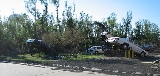
In 2005, the town was devastated by storm surge and wind associated with Hurricane KatrinaHurricane Katrina
Hurricane Katrina of the 2005 Atlantic hurricane season was a powerful Atlantic hurricane. It is the costliest natural disaster, as well as one of the five deadliest hurricanes, in the history of the United States. Among recorded Atlantic hurricanes, it was the sixth strongest overall...
which destroyed the Mississippi River-Gulf Outlet Canal
Mississippi River-Gulf Outlet Canal
The Mississippi River – Gulf Outlet Canal is a channel constructed by the United States Army Corps of Engineers in the mid-20th century that provided a shorter route between the Gulf of Mexico and New Orleans' inner harbor Industrial Canal via the Intracoastal Waterway...
(MRGO) levee.
Geography
Meraux is located at 29°55′39"N 89°55′7"W (29.927561, -89.918508).According to the United States Census Bureau
United States Census Bureau
The United States Census Bureau is the government agency that is responsible for the United States Census. It also gathers other national demographic and economic data...
, the CDP has a total area of 4.8 square miles (12.4 km²), of which, 4.2 square miles (10.8 km²) of it is land and 0.6 square miles (1.6 km²) of it (12.94%) is water.
Demographics
As of the censusCensus
A census is the procedure of systematically acquiring and recording information about the members of a given population. It is a regularly occurring and official count of a particular population. The term is used mostly in connection with national population and housing censuses; other common...
of 2000, there were 10,192 people, 3,707 households, and 2,772 families residing in the CDP. The population density
Population density
Population density is a measurement of population per unit area or unit volume. It is frequently applied to living organisms, and particularly to humans...
was 2,447.8 people per square mile (946.0/km²). There were 3,793 housing units at an average density of 911.0 per square mile (352.0/km²). The racial makeup of the CDP was 92.71% White, 3.66% African American, 0.47% Native American, 1.63% Asian, 0.33% from other races
Race (United States Census)
Race and ethnicity in the United States Census, as defined by the Federal Office of Management and Budget and the United States Census Bureau, are self-identification data items in which residents choose the race or races with which they most closely identify, and indicate whether or not they are...
, and 1.20% from two or more races. Hispanic or Latino of any race were 4.07% of the population.
There were 3,707 households out of which 38.8% had children under the age of 18 living with them, 59.6% were married couples
Marriage
Marriage is a social union or legal contract between people that creates kinship. It is an institution in which interpersonal relationships, usually intimate and sexual, are acknowledged in a variety of ways, depending on the culture or subculture in which it is found...
living together, 11.5% had a female householder with no husband present, and 25.2% were non-families. 21.8% of all households were made up of individuals and 10.8% had someone living alone who was 65 years of age or older. The average household size was 2.75 and the average family size was 3.23.
In the CDP the population was spread out with 27.4% under the age of 18, 8.7% from 18 to 24, 31.7% from 25 to 44, 22.5% from 45 to 64, and 9.7% who were 65 years of age or older. The median age was 35 years. For every 100 females there were 91.1 males. For every 100 females age 18 and over, there were 87.6 males.
The median income for a household in the CDP was $45,732, and the median income for a family was $52,408. Males had a median income of $38,727 versus $24,004 for females. The per capita income
Per capita income
Per capita income or income per person is a measure of mean income within an economic aggregate, such as a country or city. It is calculated by taking a measure of all sources of income in the aggregate and dividing it by the total population...
for the CDP was $17,951. About 6.4% of families and 9.1% of the population were below the poverty line, including 7.8% of those under age 18 and 11.3% of those age 65 or over.
Education
Residents are zoned to schools in the St. Bernard Parish Public SchoolsSt. Bernard Parish Public Schools
St. Bernard Parish Public Schools is a school district headquartered in unincorporated St. Bernard Parish, Louisiana, United States. The district operates public schools in the parish.-Schools:...
.
As of 2007 Chalmette High School
Chalmette High School
Chalmette High School is a high school in the Chalmette area unincorporated St. Bernard Parish, Louisiana, United States. It is a part of St. Bernard Parish Public Schools.Chalmette High School opened in 1954 at the current site of Chalmette Elementary School, previously known as Chalmette Middle...
serves the population.