

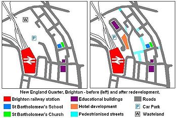
New England Quarter
Encyclopedia
Mixed-use development
Mixed-use development is the use of a building, set of buildings, or neighborhood for more than one purpose. Since the 1920s, zoning in some countries has required uses to be separated. However, when jobs, housing, and commercial activities are located close together, a community's transportation...
in the city of Brighton and Hove, England
England
England is a country that is part of the United Kingdom. It shares land borders with Scotland to the north and Wales to the west; the Irish Sea is to the north west, the Celtic Sea to the south west, with the North Sea to the east and the English Channel to the south separating it from continental...
. It was built between 2004 and 2008 on the largest brownfield site
Brownfield land
Brownfield sites are abandoned or underused industrial and commercial facilities available for re-use. Expansion or redevelopment of such a facility may be complicated by real or perceived environmental contaminations. Cf. Waste...
in the city, adjacent to Brighton railway station
Brighton railway station
Brighton railway station is the principal railway station in the city of Brighton and Hove, on the south coast of England. The station master is Mark Epsom...
. Most parts of the scheme have been finished, but other sections are still being built and one major aspect of the original plan was refused planning permission.
The site, a steeply sloping hillside between a main railway line and one of Brighton's main roads, had been the home of a railway locomotive works
Brighton railway works
Brighton railway works was one of the earliest railway-owned locomotive repair works, founded in 1840 by the London and Brighton Railway in Brighton, England, and thus pre-dating the more famous railway works at Crewe, Doncaster and Swindon...
and goods yard for more than a century. High-density housing was built at the same time and surrounded the railway buildings. From the 1960s, the area fell into decline: the works and good yard were closed and demolished, and most of the housing was cleared. This left large areas of derelict land which attracted small-scale redevelopment and transient commercial enterprises. Proposals for redevelopment were made from the 1980s onwards; in 2001 a master plan was granted planning permission by Brighton and Hove City Council. Site clearance work followed, and construction began in 2004.
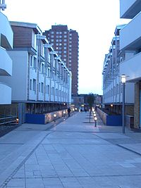
The New England Quarter consists of separately planned areas (called "Blocks" in the master plan) connected by new or altered road infrastructure and pedestrian links. Land use
Urban planning
Urban planning incorporates areas such as economics, design, ecology, sociology, geography, law, political science, and statistics to guide and ensure the orderly development of settlements and communities....
includes private and council housing
Council house
A council house, otherwise known as a local authority house, is a form of public or social housing. The term is used primarily in the United Kingdom and the Republic of Ireland. Council houses were built and operated by local councils to supply uncrowded, well-built homes on secure tenancies at...
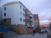
of various styles and configurations, office and retail space, a college, a hotel, public space and community facilities. Some of the residential development aims to meet high environmental and sustainability standards, and green space is being provided on former railway land.
The scheme has attracted criticism from various sources, and certain aspects and proposals have been particularly controversial. A planned 42-storey hotel and residential building on one block—which was not in the original plan and for which planning permission was later denied—was opposed by many local people and politicians, and was eventually rejected by a government minister on appeal. The decision to allow a large supermarket branch to be built in the middle of the development was also unpopular. A campaign group was formed to coordinate and raise the awareness of people's concerns.
Location
- To the north: New England Road, leading to the Seven DialsSeven Dials, BrightonSeven Dials is an area surrounding a major road junction of the same name in Brighton, in the city of Brighton and Hove. It is located on high ground just northwest of Brighton railway station, and approximately ¾ mile north of the seafront....
area - To the east: The A23 London RoadA23 roadThe A23 road is a major road in the United Kingdom between London and Brighton, East Sussex. It became an arterial route following the construction of Westminster Bridge in 1750 and the consequent improvement of roads leading to the bridge south of the river by the Turnpike Trusts...
- To the south: Trafalgar Street, leading downhill from the station towards St Peter's ChurchSt Peter's Church, BrightonSt Peter's Church is a Church of England parish church in Brighton in the English city of Brighton and Hove. It is near the centre of the town, on an island between two major roads, the A23 London Road and A270 Lewes Road. Built from 1824-28 to a design by Sir Charles Barry, it is arguably the...
, and forming the northern boundary of the North LaineNorth LaineNorth Laine is a shopping and residential district of Brighton, on the English south coast immediately adjacent to the Royal Pavilion. Once a slum area, nowadays with its many pubs and cafés, theatres and museums, it is seen as Brighton's bohemian and cultural quarter.-History:Due to its...
area - To the west: the railway station and its associated trackwork and sidings
(Some sources measure the site differently, and accordingly define it as smaller or larger than the size given in the master plan.)
History
Brighton Main Line
The Brighton Main Line is a British railway line from London Victoria and London Bridge to Brighton. It is about 50 miles long, and is electrified throughout. Trains are operated by Southern, First Capital Connect, and Gatwick Express, now part of Southern.-Original proposals:There were no fewer...
from London to Brighton in 1841 encouraged high-density housing development on the hill west of London Road. Between this area and the railway line and station stood Brighton's steam locomotive works
Brighton railway works
Brighton railway works was one of the earliest railway-owned locomotive repair works, founded in 1840 by the London and Brighton Railway in Brighton, England, and thus pre-dating the more famous railway works at Crewe, Doncaster and Swindon...
and the lower part of the station goods yard. The first locomotive was produced here in 1852. By 1896, the works employed more than 2,200 people in the manufacture and maintenance of locomotives for the London, Brighton and South Coast Railway
London, Brighton and South Coast Railway
The London, Brighton and South Coast Railway was a railway company in the United Kingdom from 1846 to 1922. Its territory formed a rough triangle, with London at its apex, practically the whole coastline of Sussex as its base, and a large part of Surrey...
. The works and its associated buildings were situated on an artificial plateau dug into the side of the chalk slopes, with the railway line on top, the works at a lower level and the lower goods yard beneath, 9 metres (29.5 ft) below track level. (The works had been extended on a pier across the lower goods yard at one point.) Production lasted until 1957, after which the buildings survived for some time before being cleared in 1969 to make way for the largest car park on what was then British Rail
British Rail
British Railways , which from 1965 traded as British Rail, was the operator of most of the rail transport in Great Britain between 1948 and 1997. It was formed from the nationalisation of the "Big Four" British railway companies and lasted until the gradual privatisation of British Rail, in stages...
's Southern Region
Southern Region of British Railways
The Southern Region was a region of British Railways from 1948. The region ceased to be an operating unit in its own right in the 1980s and was wound up at the end of 1992. The region covered south London, southern England and the south coast, including the busy commuter belt areas of Kent, Sussex...
. The lower goods yard section towards Trafalgar Street was no longer used by British Rail
British Rail
British Railways , which from 1965 traded as British Rail, was the operator of most of the rail transport in Great Britain between 1948 and 1997. It was formed from the nationalisation of the "Big Four" British railway companies and lasted until the gradual privatisation of British Rail, in stages...
after the early 1970s, although it did not finally close until 1980. Part of the land was incorporated into the car park, and the rest saw a mixture of uncoordinated uses, such as small office blocks and used car dealerships. Many of the houses adjoining the goods yard were demolished in 1962 and 1968, and some tower blocks were built nearby. Further north, a large multi-storey car park
Multi-storey car park
A multi-storey car-park is a building designed specifically to be for car parking and where there are a number of floors or levels on which parking takes place...
was built in 1976 close to St Bartholomew's Church
St Bartholomew's Church, Brighton
St Bartholomew's Church, dedicated to the apostle Bartholomew, is an Anglican church in Brighton, England. The neo-gothic building is located on Ann Street, on a sloping site between Brighton railway station and the A23 London Road, adjacent to the New England Quarter development...
.
Various proposals were put forward for more effective use of the land. The first was in 1989, when a mixed-use development, centred on a new pedestrianised square outside St Bartholomew's Church, was planned. It would have included a supermarket, offices, houses and other shops, and a relief road
Bypass (road)
A bypass is a road or highway that avoids or "bypasses" a built-up area, town, or village, to let through traffic flow without interference from local traffic, to reduce congestion in the built-up area, and to improve road safety....
designed to take traffic away from the congested London Road. The Environmental Services Department of what was then Brighton Borough Council produced a planning brief for the site in October 1993, stating a desire to "recreate in the area west of London Road a vital, urban, mixed use townscape which links a regenerated and environmentally enhanced London Road shopping centre with North Laine and the station". The desire to use the site to its full potential was increased when city status
City status in the United Kingdom
City status in the United Kingdom is granted by the British monarch to a select group of communities. The holding of city status gives a settlement no special rights other than that of calling itself a "city". Nonetheless, this appellation carries its own prestige and, consequently, competitions...
was awarded to Brighton and Hove
Brighton & Hove
Brighton and Hove is a unitary authority area and city on the south coast of England. It is England's most populous seaside resort.In 1997 Brighton and Hove were joined to form the unitary authority of Brighton and Hove, which was granted city status by Queen Elizabeth II as part of the millennium...
in 2000; it was the largest brownfield site
Brownfield land
Brownfield sites are abandoned or underused industrial and commercial facilities available for re-use. Expansion or redevelopment of such a facility may be complicated by real or perceived environmental contaminations. Cf. Waste...
in the city.
Development of the scheme
URBED (the Urban and Economic Development Group), a not-for-profitNon-profit organization
Nonprofit organization is neither a legal nor technical definition but generally refers to an organization that uses surplus revenues to achieve its goals, rather than distributing them as profit or dividends...
urban regeneration consultancy
Urban renewal
Urban renewal is a program of land redevelopment in areas of moderate to high density urban land use. Renewal has had both successes and failures. Its modern incarnation began in the late 19th century in developed nations and experienced an intense phase in the late 1940s – under the rubric of...
, designed and developed the master plan for the scheme on behalf of the New England Consortium. This is a group of companies and interested parties which together have the overall responsibility for the scheme, including Network Rail
Network Rail
Network Rail is the government-created owner and operator of most of the rail infrastructure in Great Britain .; it is not responsible for railway infrastructure in Northern Ireland...
Infrastructure Ltd, J. Sainsbury Developments Ltd and Quintain Estates and Development
Quintain Estates and Development
Quintain Estates and Development is a leading British-based property investment and development business. It is headquartered in London and is a constituent of the FTSE SmallCap Index.-History:...
(QED). The land was originally owned by British Rail
British Rail
British Railways , which from 1965 traded as British Rail, was the operator of most of the rail transport in Great Britain between 1948 and 1997. It was formed from the nationalisation of the "Big Four" British railway companies and lasted until the gradual privatisation of British Rail, in stages...
, but passed to Railtrack
Railtrack
Railtrack was a group of companies that owned the track, signalling, tunnels, bridges, level crossings and all but a handful of the stations of the British railway system from its formation in April 1994 until 2002...
when the railway system was privatised in the mid-1990s
Privatisation of British Rail
The privatisation of British Rail was set in motion when the Conservative government enacted, on 19 January 1993, the British Coal and British Rail Act 1993 . This enabled the relevant Secretary of State to issue directions to the relevant Board...
. It was sold to the New England Consortium in 1997. An initial planning application, including a new Sainsbury's supermarket, was rejected by the council in November 1997; the rejection was subsequently upheld on appeal in September 1998. URBED were then asked to develop a new master plan for the site. This design statement was published in July 2001, and was granted planning permission by Brighton & Hove City Council at the end of 2002. Construction work on the site began on 19 July 2004.
Overview of the scheme
The scheme is a mixed-use development, consisting of a wide range of residential, commercial, educational and community buildings, transport-related infrastructure and public space. The land has been divided into a series of "blocks", identified by letters, to which different types of development have been allocated. (Letters H, I and N are not used.)| Block(s) | Use | Location | Details |
|---|---|---|---|
| A-D | Residential; Community | Cheapside–New England Street–Fleet Street | Collectively known as the "Core Site". City Point (Barratt Developments); training and resource centre |
| C | Commercial | New England Street–Ann Square | Sainsbury's supermarket, three other retail units and office space |
| E-F | Residential; Community | Stroudley Road–Fleet Street–New England Street | Crest Nicholson/BioRegional Quintain Quintain Estates and Development Quintain Estates and Development is a leading British-based property investment and development business. It is headquartered in London and is a constituent of the FTSE SmallCap Index.-History:... joint venture: private and social housing, community centre |
| G | Residential; Commercial | Stroudley Road–Cross Street | Gladstone Row: Three-storey townhouses; 900 square metres (9,687.5 sq ft) workspace building |
| J | Commercial | Stroudley Road–Fleet Street | 4-star hotel (Radisson; 250 beds) |
| K | Commercial | Stroudley Road (south of Billinton Way) | 3-star hotel (Jurys Inn; 234 beds), conference facilities and offices |
| L-M | Educational | Stroudley Road (north of Billinton Way) | European headquarters of Study Group International, including Bellerbys College and Embassy CES language school Language school A language school is a school where one studies a foreign language. Classes at a language school are usually geared towards, but not limited to, communicative competence in a foreign language... |
| O-R | Car parking | Stroudley Road | New multi-storey car park for Brighton station |
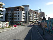
Residential areas
When the scheme is complete, at least 355 new homes will be available, consisting of a mixture of standard houses, apartments and townhouses, and able to support a population of approximately 1,000 people.In 2005, a joint venture was formed between housebuilder Crest Nicholson
Crest Nicholson
Crest Nicholson is a British housebuilding company based in Chertsey, Surrey.-History:The Company was founded by Bryan Skinner in 1963 as Crest Homes and floated on the London Stock Exchange in 1968. One of the characteristics that differentiated Crest from most other housebuilders of the time was...
and environmental project and design group BioRegional Quintain Ltd to acquire part of the site (Blocks E and F) and provide 172 of the new homes, including the affordable housing stock as mentioned above. The homes will be a mixture of one-, two- and three-bedroom flats and "eco-studios", contained within one six-storey and one ten-storey tower. This section of the development will also incorporate 925 square metres (9,956.6 sq ft) of community space, to include a community centre, and 1134 square metres (12,206.3 sq ft) of floorspace for commercial use.
The Southern Counties division of major British housebuilder Barratt Developments
Barratt Developments
Barratt Developments PLC is one of the largest residential property development companies in the United Kingdom. It was founded in 1958 as Greensitt Bros. but control was later assumed by Sir Lawrie Barratt. It was originally based in Newcastle upon Tyne but is now located at David Wilson's former...
was responsible for building City Point, the other section of the private housing development. This covers Blocks A, B, C and D, to the south of the Crest Nicholson/Bioregional development.
Block A
Block B
Covering 3953 square metres (42,549.7 sq ft), this block lies west of Block A and adjoins Fleet Street, part of the new main road through the New England Quarter. It contains a very high density of housing: 119 residential units per hectareHectare
The hectare is a metric unit of area defined as 10,000 square metres , and primarily used in the measurement of land. In 1795, when the metric system was introduced, the are was defined as being 100 square metres and the hectare was thus 100 ares or 1/100 km2...
(current government planning policy stipulates a minimum of 30 residential units per hectare, but no maximum density is advised). A retail unit and 47 residential units, none with allocated parking, make up the block. There are nine four-bedroom townhouses, 17 two-bedroom flats, 13 three-bedroom flats and eight two-bedroom duplexes
Duplex (building)
The term duplex can be used to describe several different dwelling unit configurations:A duplex house is defined as a dwelling having apartments with separate entrances for two families. This includes two-story houses having a complete apartment on each floor and also side-by-side apartments on a...
. A single unit of 124 square metres (1,334.7 sq ft) was designated for use as a shop or café; it is occupied by a fast food restaurant
Fast food restaurant
A fast food restaurant, also known as a Quick Service Restaurant or QSR within the industry itself, is a specific type of restaurant characterized both by its fast food cuisine and by minimal table service...
. The apartment blocks in Block B are four and five storeys in height. The central area enclosed by the block has been developed as a courtyard.
Block C
The residential element of this large (6432 square metres (69,233.5 sq ft)), complex block consists of 94 units, comprising four one-bedroom flats, 54 two-bedroom flats and 36 three-bedroom flats. These are all situated above the Sainsbury's supermarket, which forms a major component of the block. The flats are arranged across two apartment blocks, connected by a pedestrian route and sharing two courtyards. No parking is allocated to any of the flats. The blocks are each four storeys in height, on top of the height of the supermarket.Block D
This is another mixed-use block, with a training centre at street level. The residential element within the 3953 square metres (42,549.7 sq ft) area consists of 56 units: eight one-bedroom flats, two one-bedroom duplexes, 34 two-bedroom flats and 12 three-bedroom flats. Most of the building is five storeys high (the lowest floor being the training centre, with four residential floors above), but a further three storeys are incorporated within a tower in one corner. Again, no parking is allocated to this block.Blocks E and F

Environmentally friendly
Environmentally friendly are terms used to refer to goods and services, laws, guidelines and policies claimed to inflict minimal or no harm on the environment....
set of "eco-apartments" called One Brighton. Construction started in autumn 2007. When complete, One Brighton will consist of 172 apartments, commercial space and a community facility. The scheme has been conceived to enable people living and working there to lead sustainable lifestyles. Of these blocks' housing stock, 30% has been classified by the developers as affordable housing, which will be managed by an independent housing association
Housing association
Housing associations in the United Kingdom are independent not-for-profit bodies that provide low-cost "social housing" for people in housing need. Any trading surplus is used to maintain existing homes and to help finance new ones...
.
Block G
This will consist of three terraces of housing on top of a retaining wall alongside Stroudley Road. The ground area is 2092 square metres (22,518.1 sq ft), of which 883 square metres (9,504.5 sq ft) will be allocated to B1-categoryTown and Country Planning (Use Classes) Order 1987
The Town and Country Planning Order 1987 is a Statutory Instrument which revoked and replaced the Town and Country Planning Order 1972 as amended by the Town and Country Planning Order 1983. The 1987 order has since been amended, in 1991, 1992, 2005 , 2006 and 2010...
office and utility space. The residential elements of the development are to be three storeys high, with balconies overlooking the "green corridor" immediately to the east. No off-street car parking has been planned for this block, but some on-street parking may be provided.
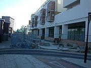
Commercial areas
Moving walkway
A moving walkway or moving sidewalk is a slow moving conveyor mechanism that transports people, across a horizontal...
. The service area and loading bay extend beneath the new road between Blocks C and D, and into the ground beneath Block D. The new store opened on 1 March 2007. It replaced a smaller outlet in London Road, which had opened in 1974 and which had seen little refurbishment since the original planning application for a Sainsbury's on the New England Quarter site was put through in 1997.
In November 2005, Block K was granted planning permission for a four-storey office development (B1-category), in addition to the hotel and public open space therein. The amount of office space had been reduced, in favour of more hotel space, since the date when outline planning permission was granted for the New England Quarter development as a whole (September 2003). 2793 square metres (30,063.6 sq ft) of office space will be provided, although the original master plan had indicated 3159 square metres (34,003.2 sq ft). Blocks A and Block B have also been provided with a small amount of space for retail use.
Hotels
Block J, which has a ground area of 3707 square metres (39,901.8 sq ft), has been granted planning permission for a luxury (four-starStar (classification)
Stars are often used as symbols for classification purposes. They are used by reviewers for ranking things such as movies, TV shows, restaurants, and hotels. For example, one to five stars is commonly employed to categorize hotels.-Restaurant ratings:...
) hotel, with around 250 beds and a range of facilities including a restaurant, swimming pool and conference venue, taking the total floor space to 21367 square metres (229,992.5 sq ft) spread across five or six storeys. The URBED master plan states that "no associated parking
Controversy arose over a proposal—raised after the master plan was approved in principle—to build a 42-storey tower incorporating a large number of residential units and other facilities in addition to the already-approved hotel. The skyscraper was proposed by the Beetham Organization
Beetham Organization
The Beetham Organisation is a privately owned property development and investment company based in Liverpool, UK. It was founded by Hugh Frost as Oastdren Investments in 1985. Its primary focus is city centre real estate, specialising in hotel, residential and office projects...
, a British property investment company, and would have been similar in scale and appearance to other recently built "Beetham Towers" in Liverpool
Beetham Tower, Liverpool
Beetham Tower, Liverpool is a residential apartment building in the British city of Liverpool. Its close neighbour and the tallest building in Liverpool, the West Tower was also developed by the Beetham Organization....
, Manchester
Beetham Tower, Manchester
Beetham Tower is a landmark 47-storey residential skyscraper in Manchester city centre, England. Completed in 2006, it is named after the developers, Beetham Organization, was designed by Ian Simpson, and built by Carillion....
and Birmingham. Architects Allies and Morrison
Allies and Morrison
Allies and Morrison is a London-based architectural practice founded by Bob Allies and Graham Morrison in 1984. The practice is now headed up by 10 Partners and employs around 210 people in their purpose designed studios at 85 Southwark Street...
drew up the design.
There was much criticism of the design, its height and the proposed location, both from local councillors (of all parties) and from people in the local community. Planning permission was denied in April 2005, but the Beetham Organization lodged an appeal and a public inquiry
Public inquiry
A Tribunal of Inquiry is an official review of events or actions ordered by a government body in Common Law countries such as the United Kingdom, Ireland or Canada. Such a public inquiry differs from a Royal Commission in that a public inquiry accepts evidence and conducts its hearings in a more...
was held in November 2006. Ruth Kelly
Ruth Kelly
Ruth Maria Kelly is a British Labour Party politician of Irish descent who was the Member of Parliament for Bolton West from 1997 until she stood down in 2010...
, the Secretary of State for Communities and Local Government
Secretary of State for Communities and Local Government
The Secretary of State for Communities and Local Government, is a Cabinet position heading the UK's Department for Communities and Local Government....
, was responsible for deciding whether to overrule the council's decision and approve the tower. A final decision on the site was initially expected in February 2007, but the inquiry eventually continued until 17 May 2007, when the decision to refuse planning permission was upheld. As well as agreeing with the council's original argument that the tower would not fit into the local area and would have a harmful effect on surrounding conservation areas (such as the North Laine
North Laine
North Laine is a shopping and residential district of Brighton, on the English south coast immediately adjacent to the Royal Pavilion. Once a slum area, nowadays with its many pubs and cafés, theatres and museums, it is seen as Brighton's bohemian and cultural quarter.-History:Due to its...
and St Bartholomew's Church), Kelly stated that the proposal would give insufficient benefit in terms of regeneration of the area, and did not offer enough outdoor leisure and recreation space. The future of the Block J site is undecided as a result of this; however, within four days of the decision, the Beetham Organization announced that it intended to submit plans for an alternative scheme, which it would develop in consultation with the city council.
Block K was acquired by the Jurys Doyle Hotel Group PLC, which operated hotels under the "Jurys Inn" brand until it sold its portfolio in 2007. It houses a three-star
Star (classification)
Stars are often used as symbols for classification purposes. They are used by reviewers for ranking things such as movies, TV shows, restaurants, and hotels. For example, one to five stars is commonly employed to categorize hotels.-Restaurant ratings:...
hotel, built over five and six storeys, as well as offices and public space. It has a floor area of 10518 square metres (113,214.8 sq ft), and there are 234 bedrooms, various meeting rooms and similar facilities. The hotel was built by Northern Irish construction group McAleer & Rushe. It opened in late 2007.
Education and community
The Black and Minority Ethnic Community Partnership, a grant-aided registered charityCharitable organization
A charitable organization is a type of non-profit organization . It differs from other types of NPOs in that it centers on philanthropic goals A charitable organization is a type of non-profit organization (NPO). It differs from other types of NPOs in that it centers on philanthropic goals A...
, leases the ground and first floors of Block D from Sainsbury's. The space is used as a community training and resource centre.
Block F will be mostly allocated to community use. This area originally had a collection of old buildings which had originally been part of the locomotive works. Subsequently, they had been put to various uses, such as a camping goods shop and a furniture outlet. A third building, behind these shops, was believed to have been used as a "clocking-on" point for employees at the works, who would go there to register their presence each day before starting work. By 2002, it consisted mostly of a series of staircases, bridges and ramps, and was in poor condition.
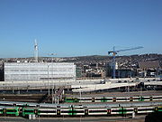
Car parking
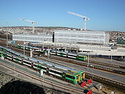
Blocks O-R of the development make up Brighton station car park. This has two decks, a ground area of 8884 square metres (95,626.6 sq ft) and 600 spaces, of which 26 are for disabled drivers. A pick-up and drop-off point with motorcycle parking and a turning circle is situated between the car park and the side entrance to the station. This was the first part of the New England Quarter to be completed; most of the work was undertaken by the Adenstar Construction Group, based in nearby PortsladePortslade
Portslade is the name of an area of the city of Brighton and Hove, England. Portslade Village, the original settlement a mile inland to the north, was built up in the 16th century...
. There was a contractual obligation to provide 600 spaces, although the form which this had to take was not specified and various proposals were considered, including a taller multi-storey structure with more floors and a much smaller ground area. During the construction works, a temporary car park was provided on land nearby.
There is relatively little parking elsewhere on the site, other than the 190-space facility at the Sainsbury's supermarket; this is partly mitigated by the retention of the London Road multi-storey car park, located between Block C and the A23 London Road itself. The residential areas in particular have very few dedicated parking spaces. Block K will have 27 spaces to be shared between the hotel and the office building; nine of these will be for disabled drivers. The master plan proposed 34 (including five on-street spaces), all of which were allocated to the office building.
Changes to the road layout
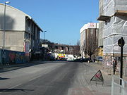
The largest change has been the downgrading of the former through route of New England Street in favour of a new north-south road, Fleet Street, which diverges to the west. This has allowed a large part of New England Street to be narrowed, pedestrianised and provided with cycle lanes. In contrast, Cheapside is expected to take a much higher volume of traffic, as it becomes the main east-west route in the New England Quarter, taking traffic between London Road and Fleet Street, the main north-south road. Two new roads, Stroudley Road and Billinton Road, have been built to the west of the new Fleet Street, between there and the railway line. These give access to the car park, Bellerbys College and a new pick-up and drop-off point immediately outside the side entrance to the station. Two new pedestrianised squares—Ann Square and New England Square—have also been created within the core site.
Transport
Some Brighton & Hove Bus routesBrighton & Hove Bus and Coach Company
Brighton & Hove Bus and Coach Company operates almost all bus services in the city of Brighton and Hove in southern England. The company was established in 1884 as Brighton, Hove and Preston United Omnibus Company and has been part of the Go-Ahead Group since 1993.The company currently operates a...
serve the New England Quarter. There are stops at various locations on Cheapside, Fleet Street and New England Street.
- Route 21 runs every 20 minutes (hourly on Sundays) from Brighton MarinaBrighton MarinaBrighton Marina is an artificial marina situated in Brighton, England. The construction of the marina itself took place between 1971 and 1979, although developments within it have continued ever since. The marina covers an area of approximately...
via WhitehawkWhitehawkWhitehawk is a suburb in the east of Brighton, part of the English city of Brighton and Hove.The area is a large, modern housing estate built in a downland dry valley historically known as Whitehawk Bottom. The estate was originally developed by the local authority between 1933 and 1937 and...
to the rear entrance of Brighton station in Stroudley Road. - Route 37 runs every 20 minutes (30 minutes on Sundays) from the Bristol Estate, west of WhitehawkWhitehawkWhitehawk is a suburb in the east of Brighton, part of the English city of Brighton and Hove.The area is a large, modern housing estate built in a downland dry valley historically known as Whitehawk Bottom. The estate was originally developed by the local authority between 1933 and 1937 and...
, to the Meadowview area of BevendeanBevendeanBevendean is a district of the city of Brighton and Hove, in East Sussex, England.The estate lies to the north-east of central Brighton, and was largely developed after World War II with a mixture of council housing and private development. A large proportion of the council houses are now privately...
. - Route 88 is a peak-hour bus which runs on a circular route from HollingburyHollingburyHollingbury is an area of the city of Brighton and Hove, East Sussex. The area sits high on a hillside across the north of the city above Patcham which lies in a valley to the west, Coldean in a valley to the east, and the A27 bypass forming the northern limit...
via several of Brighton's colleges and university buildings. Two morning and three afternoon journeys travel through the New England Quarter.
The area is close to many other bus routes, both from outside the front entrance of Brighton station and along London Road. There is a direct pedestrian and vehicular route along Stroudley Road to the rear entrance of Brighton station.
Environmental issues
Part of the site, below and to the east of Block G, consists of a stretch of disused railway track which has for some time been designated a Site of Special Nature Conservation ImportanceSite of Nature Conservation Interest
Site of Nature Conservation Interest is a designation used in many parts of the United Kingdom to protect areas of importance for wildlife and geology at a county scale...
(SNCI). This is defined as a "locally important site of nature conservation adopted by local authorities for planning purposes". This will be maintained and improved to create a "green corridor" called the Greenway, which will run from the embankment overlooking New England Road, at the northernmost point of the site (beyond Blocks L and M), through to the station. The northern section, which is already partly wooded and home to a variety of wildlife, will be maintained in this condition.
The housing developed by the Crest Nicholson/BioRegional Quintain joint venture is intended to encourage environmentally friendly, sustainable lifestyles, based on lessons learnt from the award-winning BedZED
BedZED
Beddington Zero Energy Development is an environmentally friendly housing development in Hackbridge, London, England. It is in the London Borough of Sutton. It was designed by the architect Bill Dunster to support a more sustainable lifestyle...
development in Wallington
Wallington, London
Wallington is a town in the London Borough of Sutton situated south south-west of Charing Cross. Prior to the merger of the Municipal Borough of Beddington and Wallington into the London Borough of Sutton, it was part of the county of Surrey.- History :...
, south London. This was developed by the Peabody Trust
Peabody Trust
Peabody Trust , founded in 1862, is one of London's oldest and largest housing associations with over 19,000 properties. It also a charity and urban regeneration agency...
in partnership with BioRegional Development Group. Proposals include "green lifestyle" packs and information for residents, solar panels, a communal wood-burning boiler to heat the apartments and provide hot water, solar-powered recharging point for electric cars
Battery electric vehicle
A battery electric vehicle, or BEV, is a type of electric vehicle that uses chemical energy stored in rechargeable battery packs. BEVs use electric motors and motor controllers instead of, or in addition to, internal combustion engines for propulsion.A battery-only electric vehicle or...
, roof-mounted wind turbines, a community allotment/garden irrigated by rainwater from the roof, a car club, and a high proportion of recycled materials used in construction.
Criticism and controversy
Various groups have expressed reservations about, and criticisms of, parts of the New England Quarter development or the scheme as a whole. Two aspects have been particularly controversial: the planning application for a 42-storey tower on the Block J site, which was refused but has been appealed against; and the Sainsbury's supermarket.BUDD
Brighton Urban Design & Development (BUDD) is a campaign group which was set up in February 1997 in response to the original planning application for a Sainsbury's superstore and car park on what is now the New England Quarter site. Although initially created to oppose and protest against these original plans, it has subsequently developed into an all-encompassing point of contact for all issues relating to the New England Quarter, and its stated aim is now to "stimulate, encourage and initiate sustainable urban design and development through an inclusive participatory process, to combat social exclusion and to generate schemes that integrate social, cultural and environmental benefits to Brighton and Hove." In 1999, Brighton & Hove Council awarded the group a grant which enabled it to register as an Industrial and Provident SocietyIndustrial and Provident Society
An industrial and provident society is a legal entity for a trading business or voluntary organisation in the United Kingdom, the Republic of Ireland, and New Zealand...
, noting that it was providing a significant community benefit by "providing a process for disparate communities of interest to develop their views and become involved in the planning and decision-making process".
BUDD held a public meeting was on 24 July 1997, at which 99% of the approximately 300 people who attended voted against the original planning application, which had been submitted in May following several months of preparation. A 4,317-name petition to the same effect was submitted to the council three months later. Marches and rallies also took place.
After the new master plan was submitted and approved, further action was taken by protestors; this was focused on the Harvest Forestry building at the corner of New England Street and Cheapside, which was squatted
Squatting
Squatting consists of occupying an abandoned or unoccupied space or building, usually residential, that the squatter does not own, rent or otherwise have permission to use....
for a time.
SchNEWS
SchNEWSSchNEWS
SchNEWS is a free weekly publication from Brighton, England, which has been running since November 1994. The main focus is environmental and social issues/struggles in the UK – but also internationally – with an emphasis on direct action protest, and autonomous political struggles...
, a weekly anarchist newsletter, has frequently been critical of the plans for the New England Quarter site, and has regularly advertised BUDD's public meetings, protest events and similar. In April 2002, a demonstration was organised outside the Sainsbury's store in London Road.
Block J proposals
The original master plan granted outline planning permission for a 250-bed hotel of five to six storeys in height. However, property development and investment company The Beetham Organization Ltd, which has in recent years built several high-profile hotels, offices and other buildings in prominent city-centre locations in Britain, bought Block J in November 2004 and submitted a revised planning application (BH2005/00136/FP) early in 2005. This sought approval for a mixed-use development comprising one 42-storey building with 146 residential units (C3-categoryTown and Country Planning (Use Classes) Order 1987
The Town and Country Planning Order 1987 is a Statutory Instrument which revoked and replaced the Town and Country Planning Order 1972 as amended by the Town and Country Planning Order 1983. The 1987 order has since been amended, in 1991, 1992, 2005 , 2006 and 2010...
) and a hotel with ancillary facilities including a restaurant, cafés, conference facilities and a health and fitness centre; one six-storey building with retail units (A1- and A3-category) and a further 25 residential units; and a pedestrianised public square. The application was rejected on 20 separate counts, including the negative visual impact on surrounding listed buildings such as the railway station and St Bartholomew's Church; the reduction in quality of surrounding public spaces; the lack of provision of outdoor recreation space; negative effect on the surrounding microclimate
Microclimate
A microclimate is a local atmospheric zone where the climate differs from the surrounding area. The term may refer to areas as small as a few square feet or as large as many square miles...
, and loss of sunlight to nearby buildings; and the failure to consider fully the impact on transport. The reasons for the rejection were supported by various people and groups within the city, such as The Regency Society, which is involved with planning and conservation matters in Brighton and Hove.
The design statement
| Part | Section Contents | Pages |
|---|---|---|
| 1 | Contents and Introduction | 3 |
| 2 | Historical overview and analysis of the site | 12 |
| 3 | Master plan details, including maps and diagrams | 14 |
| 4 | Public spaces and landscaping proposals | 9 |
| 5 | "Core Site" proposals (Blocks A-D) | 8 |
| 6 | Details of each Block, including diagrams | 12 |