

Brighton & Hove
Encyclopedia
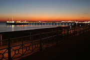
Brighton and Hove is a unitary authority area and city
on the south coast of England. It is England's most populous seaside resort
.
In 1997 Brighton
and Hove
were joined to form the unitary authority of Brighton and Hove, which was granted city status by Queen Elizabeth II as part of the millennium celebrations in 2000.
Brighton and Hove forms part of the Brighton/Worthing/Littlehampton
conurbation
, the 12th largest conurbation in the United Kingdom
. Along this area of the south coast, there is little or no gap of countryside between these large towns and city. Directly to the west is Shoreham-by-Sea
, and a short distance to the east are Peacehaven
and Newhaven
. The city, district and urban areas of Brighton and Hove have the biggest populations in the South East England
region.
Brighton and Hove themselves were results of amalgamations:
The football team, Brighton & Hove Albion F.C.
, predates the unification of the two boroughs by 96 years.
On 15 October 2004, Brighton and Hove was granted Fairtrade City status.
The resident population of Brighton and Hove at the 2001 census was 247,817 persons, comprising 114,479 households: 48.4% male, 51.5% female.
In the same census, Brighton and Hove had the highest percentage of citizens indicating their religion
as Jedi
among all principal area
s of England and Wales
).
The next census was carried out on 27 March 2011.
of 2000 that confers City status is worded thus:
City status in the United Kingdom
City status in the United Kingdom is granted by the British monarch to a select group of communities. The holding of city status gives a settlement no special rights other than that of calling itself a "city". Nonetheless, this appellation carries its own prestige and, consequently, competitions...
on the south coast of England. It is England's most populous seaside resort
Seaside resort
A seaside resort is a resort, or resort town, located on the coast. Where a beach is the primary focus for tourists, it may be called a beach resort.- Overview :...
.
In 1997 Brighton
Brighton
Brighton is the major part of the city of Brighton and Hove in East Sussex, England on the south coast of Great Britain...
and Hove
Hove
Hove is a town on the south coast of England, immediately to the west of its larger neighbour Brighton, with which it forms the unitary authority Brighton and Hove. It forms a single conurbation together with Brighton and some smaller towns and villages running along the coast...
were joined to form the unitary authority of Brighton and Hove, which was granted city status by Queen Elizabeth II as part of the millennium celebrations in 2000.
Brighton and Hove forms part of the Brighton/Worthing/Littlehampton
Brighton/Worthing/Littlehampton
The Brighton/Worthing/Littlehampton conurbation has a population of 461,181 , making it the 12th largest conurbation in the United Kingdom, after Greater Belfast and ahead of Edinburgh. It is England's 10th largest conurbation. Named the Brighton/Worthing/Littlehampton conurbation by the Office...
conurbation
Conurbation
A conurbation is a region comprising a number of cities, large towns, and other urban areas that, through population growth and physical expansion, have merged to form one continuous urban and industrially developed area...
, the 12th largest conurbation in the United Kingdom
United Kingdom
The United Kingdom of Great Britain and Northern IrelandIn the United Kingdom and Dependencies, other languages have been officially recognised as legitimate autochthonous languages under the European Charter for Regional or Minority Languages...
. Along this area of the south coast, there is little or no gap of countryside between these large towns and city. Directly to the west is Shoreham-by-Sea
Shoreham-by-Sea
Shoreham-by-Sea is a small town, port and seaside resort in West Sussex, England. Shoreham-by-Sea railway station is located less than a mile from the town centre and London Gatwick Airport is away...
, and a short distance to the east are Peacehaven
Peacehaven
Peacehaven is a town and civil parish in the Lewes district of East Sussex, England. It is located above the chalk cliffs of the South Downs approximately six miles east of Brighton city centre, on the A259 road...
and Newhaven
Newhaven, East Sussex
Newhaven is a town in the Lewes District of East Sussex in England. It lies at the mouth of the River Ouse, on the English Channel coast, and is a ferry port for services to France.-Origins:...
. The city, district and urban areas of Brighton and Hove have the biggest populations in the South East England
South East England
South East England is one of the nine official regions of England, designated in 1994 and adopted for statistical purposes in 1999. It consists of Berkshire, Buckinghamshire, East Sussex, Hampshire, Isle of Wight, Kent, Oxfordshire, Surrey and West Sussex...
region.
Brighton and Hove themselves were results of amalgamations:
- Brighton was incorporated as a municipal boroughMunicipal boroughMunicipal boroughs were a type of local government district which existed in England and Wales between 1835 and 1974, in Northern Ireland from 1840 to 1973 and in the Republic of Ireland from 1840 to 2002...
in 1854, later becoming a county boroughCounty boroughCounty borough is a term introduced in 1889 in the United Kingdom of Great Britain and Ireland , to refer to a borough or a city independent of county council control. They were abolished by the Local Government Act 1972 in England and Wales, but continue in use for lieutenancy and shrievalty in...
under the Local Government Act 1888Local Government Act 1888The Local Government Act 1888 was an Act of the Parliament of the United Kingdom, which established county councils and county borough councils in England and Wales...
; it covered the parish of Brighton and part of Preston - Hove became a local board of health in the late 19th century, originally covering the parish of Hove
- In 1893 the parish of AldringtonAldringtonAldrington is the name of an area of the city of Brighton and Hove, previously part of the old borough of Hove. For centuries it was meadow land along the English Channel stretching west from the old village of Hove to the old mouth of the River Adur, and it is now a prosperous residential area...
was added to Hove local board - Hove became incorporated as a municipal borough in 1898
- HangletonHangletonHangleton is an estate in west Hove, East Sussex. The estate was developed circa the late 1930s after the Dyke railway was closed.It contains both the oldest building in the city of Brighton and Hove, St Helen's Church, and the second oldest building: that which was Hangleton Manor and is now the...
, Preston Rural and West BlatchingtonWest BlatchingtonWest Blatchington is an area in Hove, East Sussex, England.The area grew rapidly in the inter-war period, but unlike nearby Hangleton it had more infrastructure, with St Peter's Church, a working farm, a windmill and an industrial area grouped around the Goldstone Pumping Station and its workers'...
were added to Hove in 1928 - OvingdeanOvingdeanOvingdean is a small formerly agricultural village which was absorbed into the borough of Brighton, East Sussex, UK, in 1928, and now forms part of the city of Brighton and Hove. It has expanded through the growth of residential streets on its eastern and southern sides, and now has a population of...
, PatchamPatchamPatcham is an area of the city of Brighton and Hove. It is approximately north of the city centre, bounded by the A27 to the north, Hollingbury to the east and southeast, Withdean to the south and the Brighton Main Line to the west...
and RottingdeanRottingdeanRottingdean is a coastal village next to the town of Brighton and technically within the city of Brighton and Hove, in East Sussex, on the south coast of England...
were added to Brighton in 1928 - Portslade-by-Sea was added to Hove in 1974 under the Local Government Act 1972Local Government Act 1972The Local Government Act 1972 is an Act of Parliament in the United Kingdom that reformed local government in England and Wales on 1 April 1974....
: both Brighton and Hove became non-metropolitan districts of East Sussex
The football team, Brighton & Hove Albion F.C.
Brighton & Hove Albion F.C.
Brighton & Hove Albion Football Club are an English association football club based in the coastal city of Brighton & Hove, East Sussex. They currently play in the Football League Championship, the second tier of the English football league system....
, predates the unification of the two boroughs by 96 years.
On 15 October 2004, Brighton and Hove was granted Fairtrade City status.
Political composition
Elections are held every four years, with the last elections occurring on May 5, 2011.| Party | Councillors | Change (on 2007) |
|
|---|---|---|---|
| 23 | +10 | ||
| 18 | −8 | ||
| 13 | ±0 | ||
| 0 | −2 | ||
| 0 | NC | ||
| Total | 54 | - | |
| Source: Brighton & Hove City Council | |||
Administration and directorates
The leader of the council elected on 19 May 2011 is Councillor Bill Randall (Green Party), although the Greens only hold a minority of seats. The current mayor of Brighton and Hove is Councillor Anne Meadows. John Barradell, OBE, started as Chief Executive on 1 October 2009. There are six directorates in the council structure.Council priorities
Introduced in June 2008, the council's corporate priorities are:- protect the environment whilst growing the economy
- better use of public money
- reduce inequality by increasing opportunities
- fair enforcement of the law
- open and effective city leadership
Towns and districts
The city of Brighton and Hove comprises the following areas (not necessarily directly corresponding to administrative wards or parishes):- former borough of Brighton
- BevendeanBevendeanBevendean is a district of the city of Brighton and Hove, in East Sussex, England.The estate lies to the north-east of central Brighton, and was largely developed after World War II with a mixture of council housing and private development. A large proportion of the council houses are now privately...
- Black RockBlack Rock (Brighton and Hove)Black Rock is an area of wasteland located near Brighton Marina in the city of Brighton and Hove.-History:From at least the early 19th Century , Black Rock was the site of an inn and a few houses overlooking cliffs to the east of the then town of Brighton....
- BrightonBrightonBrighton is the major part of the city of Brighton and Hove in East Sussex, England on the south coast of Great Britain...
- ColdeanColdeanColdean is a suburb of Brighton and Hove, England and is one of its most well defined and self contained. Unlike its neighbours Moulsecoomb or Hollingbury, it sits in a steep sided valley on the extreme north-east of the city...
- HanoverHanover, Brightonthumb|right|Hanover Day 2007.Hanover is an area within the city of Brighton and Hove, United Kingdom. It is part of the electoral ward of Hanover & Elm Grove....
- HollingburyHollingburyHollingbury is an area of the city of Brighton and Hove, East Sussex. The area sits high on a hillside across the north of the city above Patcham which lies in a valley to the west, Coldean in a valley to the east, and the A27 bypass forming the northern limit...
- HollingdeanHollingdeanHollingdean is a part of the city of Brighton & Hove.Hollingdean is in effect the older part of Hollingbury south of the park. It is bounded by Ditchling Road to the west, the Round Hill area to the south, and Lewes Road and Moulsecoomb to the east...
- KemptownKemptownKemptown is a small community running along the King's Cliff to Black Rock in the east of Brighton, East Sussex, England.-History:The area takes its name from Thomas Read Kemp's Kemp Town residential estate of the early 19th Century, but the one-word name now refers to an area larger than the...
— built up around a self-contained development of 1823, Kemp TownKemp TownKemp Town is a 19th Century residential estate in the east of Brighton in East Sussex, England, UK. Kemp Town was conceived and financed by Thomas Read Kemp. It has given its name to the larger Kemptown region of Brighton.... - The LanesThe Lanes (Brighton)The Lanes are a collection of narrow lanes in Brighton, in the city of Brighton and Hove famous for their small shops and narrow alleyways.-History:...
- Brighton MarinaBrighton MarinaBrighton Marina is an artificial marina situated in Brighton, England. The construction of the marina itself took place between 1971 and 1979, although developments within it have continued ever since. The marina covers an area of approximately...
- MoulsecoombMoulsecoombMoulsecoomb is a large suburb of Brighton, part of the city of Brighton and Hove. It is located on the northeastern side of Brighton, around the A270 Lewes Road, between the areas of Coldean and Bevendean and approximately 2¼ miles north of the seafront. The eastern edges of the built-up area...
- New England QuarterNew England QuarterThe New England Quarter is a mixed-use development in the city of Brighton and Hove, England. It was built between 2004 and 2008 on the largest brownfield site in the city, adjacent to Brighton railway station...
— a large new mixed-use development - North LaineNorth LaineNorth Laine is a shopping and residential district of Brighton, on the English south coast immediately adjacent to the Royal Pavilion. Once a slum area, nowadays with its many pubs and cafés, theatres and museums, it is seen as Brighton's bohemian and cultural quarter.-History:Due to its...
- OvingdeanOvingdeanOvingdean is a small formerly agricultural village which was absorbed into the borough of Brighton, East Sussex, UK, in 1928, and now forms part of the city of Brighton and Hove. It has expanded through the growth of residential streets on its eastern and southern sides, and now has a population of...
- PatchamPatchamPatcham is an area of the city of Brighton and Hove. It is approximately north of the city centre, bounded by the A27 to the north, Hollingbury to the east and southeast, Withdean to the south and the Brighton Main Line to the west...
- Preston ParkPreston Park, BrightonPreston Park is a park near Preston Village in the city of Brighton and Hove, East Sussex, England. It is located in Preston Park ward to the north of the centre of Brighton, and served by the nearby Preston Park railway station....
- Preston VillagePreston Village, BrightonPreston Village is a suburban area of Brighton and Hove, East Sussex to the north of the centre. Originally a village in its own right, it was eventually absorbed into Brighton with the development of the farmland owned by the local Stanford family, officially becoming a parish of the town in 1928...
- Rottingdean VillageRottingdeanRottingdean is a coastal village next to the town of Brighton and technically within the city of Brighton and Hove, in East Sussex, on the south coast of England...
- Queen's ParkQueen's Park, BrightonQueen's Park is an administrative ward and a public park in Brighton, England.The area lies to the east of the centre of Brighton, north of Kemptown and south-east of Hanover. It is largely made up of Victorian terraced houses, with a smaller number of detached and semi-detached houses...
- SaltdeanSaltdeanSaltdean is a residential district located on the chalk cliffs of the south coast of England in East Sussex, United Kingdom. It is situated on the eastern edge of the city of Brighton and Hove, with part outside the city boundary in Lewes district...
(West) - StanmerStanmerStanmer is a small village on the eastern outskirts of Brighton, in East Sussex, England.-History:Stanmer village pond is surrounded by sarsen stones, which accounts for the place-name, Old English for 'stone pond'. The stones are not in their original situation, but have been gathered on the Downs...
- WestdeneWestdeneWestdene is an area of the city of Brighton and Hove, East Sussex. It is a northern suburb of the city, west of Patcham, the A23 and the London to Brighton railway line, north of Withdean and northeast of West Blatchington. It is on the Brighton side of the historic parish boundary between...
- WhitehawkWhitehawkWhitehawk is a suburb in the east of Brighton, part of the English city of Brighton and Hove.The area is a large, modern housing estate built in a downland dry valley historically known as Whitehawk Bottom. The estate was originally developed by the local authority between 1933 and 1937 and...
- Withdean
- WoodingdeanWoodingdeanWoodingdean is an eastern suburb of the city of Brighton and Hove, East Sussex, separated from the main part of the city by downland and the Brighton Racecourse.-Source of name:...
- SaltdeanSaltdeanSaltdean is a residential district located on the chalk cliffs of the south coast of England in East Sussex, United Kingdom. It is situated on the eastern edge of the city of Brighton and Hove, with part outside the city boundary in Lewes district...
- former borough of Hove
- AldringtonAldringtonAldrington is the name of an area of the city of Brighton and Hove, previously part of the old borough of Hove. For centuries it was meadow land along the English Channel stretching west from the old village of Hove to the old mouth of the River Adur, and it is now a prosperous residential area...
- Brunswick — developed 1824 in a similar manner to Kemp Town (see above)
- HangletonHangletonHangleton is an estate in west Hove, East Sussex. The estate was developed circa the late 1930s after the Dyke railway was closed.It contains both the oldest building in the city of Brighton and Hove, St Helen's Church, and the second oldest building: that which was Hangleton Manor and is now the...
- HoveHoveHove is a town on the south coast of England, immediately to the west of its larger neighbour Brighton, with which it forms the unitary authority Brighton and Hove. It forms a single conurbation together with Brighton and some smaller towns and villages running along the coast...
- Knoll (see also neighbouring Hangleton, above)
- Mile OakMile OakMile Oak is a locality forming the northern part of the former parish of Portslade in the north-west corner of the city of Brighton and Hove, England....
- Portslade by SeaPortsladePortslade is the name of an area of the city of Brighton and Hove, England. Portslade Village, the original settlement a mile inland to the north, was built up in the 16th century...
- Portslade VillagePortsladePortslade is the name of an area of the city of Brighton and Hove, England. Portslade Village, the original settlement a mile inland to the north, was built up in the 16th century...
- Tongdean
- St. Ann's Well
- West BlatchingtonWest BlatchingtonWest Blatchington is an area in Hove, East Sussex, England.The area grew rapidly in the inter-war period, but unlike nearby Hangleton it had more infrastructure, with St Peter's Church, a working farm, a windmill and an industrial area grouped around the Goldstone Pumping Station and its workers'...
Census
The first census of Brighton was in 1801.The resident population of Brighton and Hove at the 2001 census was 247,817 persons, comprising 114,479 households: 48.4% male, 51.5% female.
In the same census, Brighton and Hove had the highest percentage of citizens indicating their religion
Jedi census phenomenon
The Jedi census phenomenon is a grassroots movement that was initiated in 2001 for residents of a number of English-speaking countries, urging them to record their religion as "Jedi" or "Jedi Knight" on the national census.It is believed the majority of self-reported Jedi claimed the religion for...
as Jedi
Jediism
Jediism is a religious movement based on the philosophical and spiritual ideas of the Jedi as depicted in Star Wars media.-Belief:Practitioners identify themselves with the Jedi Knights in Star Wars, believe in the existence of the Force and that interaction with the Force is possible. Believers...
among all principal area
Principal area
In England and Wales local government legislation, a principal area is one of the various sub-national areas established for control by a principal council...
s of England and Wales
England and Wales
England and Wales is a jurisdiction within the United Kingdom. It consists of England and Wales, two of the four countries of the United Kingdom...
).
The next census was carried out on 27 March 2011.
Wording of the Letters Patent
The Letters PatentLetters patent
Letters patent are a type of legal instrument in the form of a published written order issued by a monarch or president, generally granting an office, right, monopoly, title, or status to a person or corporation...
of 2000 that confers City status is worded thus:
ELIZABETH the SECOND BY THE GRACE OF GOD OF THE UNITED KINGDOM OF GREAT BRITAIN AND NORTHERN IRELAND & OF OUR REALMS & TERRITORIES QUEEN HEAD OF THE COMMON WEALTH DEFENDER OF THE FAITH.
To all to whom these Presents shall come Greeting. Whereas We for divers good causes and considerations Us thereunto moving are graciously pleased to confer on the Towns of Brighton and Hove the status of a city Now Therefore Know Ye that We of Our especial grace and favour and mere motion do by these Presents ordain declare and direct that the TOWNS OF BRIGHTON AND HOVE shall henceforth have the status of a CITY and shall have all such rank liberties privileges and immunities as are incident to a City. In witness whereof We have caused Our Letters to be made Patent Witness Ourself at Westminster the thirty first day of January in the forty ninth year of our reign.
By Warrant under The Queens Sign Manual Phillips.
Economy
This is a chart of trend of regional gross value added of Brighton and Hove at current basic prices published (pp. 240–253) by Office for National Statistics with figures in millions of British Pounds Sterling.| Year | Regional Gross Value Added | Agriculture | Industry | Services |
|---|---|---|---|---|
| 1995 | 2,656 | 3 | 407 | 2,246 |
| 2000 | 3,101 | 3 | 378 | 2,721 |
| 2003 | 3,952 | 4 | 476 | 3,472 |
See also
- See the BrightonBrightonBrighton is the major part of the city of Brighton and Hove in East Sussex, England on the south coast of Great Britain...
and HoveHoveHove is a town on the south coast of England, immediately to the west of its larger neighbour Brighton, with which it forms the unitary authority Brighton and Hove. It forms a single conurbation together with Brighton and some smaller towns and villages running along the coast...
articles for descriptions of the twin towns, and the Brighton and Hove category for further articles about places and things in the district.
- List of Grade I listed buildings in Brighton and Hove
- List of notable Brighton and Hove inhabitants
- Brighton and Hove City CentreBrighton and Hove city centreBrighton and Hove City Centre is the commercial and cultural centre of the city of Brighton. Geographically, the so-called city centre is actually located in an easterly part of the Brighton and Hove urban conurbation.- Culture :...
- List of Brighton & Hove bus names
External links
- Map Of Brighton & Hove Interactive map of Brighton & Hove, with locations of businesses and other points of interest
- Brighton and Hove Issues Forum - Local discussion forum
- Brighton and Hove News