

Hollingbury
Encyclopedia
Hollingbury is an area of the city of Brighton and Hove, East Sussex
. The area sits high on a hillside across the north of the city above Patcham
which lies in a valley to the west, Coldean
in a valley to the east, and the A27
bypass forming the northern limit. To the south it blends into leafy Surrenden and the busy Fiveways shopping area.
Hollingbury Hill itself reaches an elevation of 584 feet (178 m) above sea level and on the summit is Hollingbury Castle Camp, an Iron Age
hill fort
dating from around the sixth century B.C. It is where Triangulation Point
(or Trigpoint) TP3970 used for the 1936 Ordnance Survey
mapping of Great Britain
is located.
The north-western slopes of the hill have been developed and are populated with housing dating from the 1940s onwards with minor retail and industrial use.
 The hill fort is located within Hollingbury Park, an area of approximately 240 acre (0.9712464 km²; 0.375000331565229 sq mi) most of which is occupied by the municipal golf course, designed in 1907 and remodelled in 1936. The park also contains football pitches, six tennis court
s, a bowling green
and a children’s playground. For many years the park was known by locals as "The Rocket Park" on account of the rocket-shaped climbing frame in the playground but this was removed and the playground extended in the early 1980s. An area towards the northern end of the park is fenced off and contains a weather station and underground reservoir. On a clear day, the park offers views over the city to the English Channel.
Adjacent to the park is an area of woodland planted in the nineteenth century; the majority of this was destroyed in the Great Storm of October 1987
. The local council maintains an easy access trail through the woodland.
Carden Park, located towards the north-east of the estate between Carden school and the industrial estate, occupies approximately 12 acre (0.04856232 km²; 0.0187500165782614 sq mi) and was originally laid out in the 1950s. The original tennis courts and swings were lost during industrial development in 1968 and the park now contains a football pitch and play area for young children.
 As part of the Asda
development in 1987, the company built a local community centre, known as Old Boat Corner Community Centre, situated in Carden Park which opened in April 1998. Today the centre is thriving and is very much open to local residents. The Community Centre has a members Social Club and there are lots of different groups running from the Centre including Sports Clubs, Over 60s Clubs, Toddler Groups and Drama Classes. Full details can be found on the website.
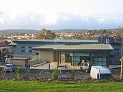 In 2008, a purpose-built medical centre (County Oak medical centre) opened on the previously unused space in the southern corner of Carden School grounds. The building is eco-friendly, making use of solar panels for heating and light tubes to transmit natural daylight into the building.
 The small branch library in Carden Hill opened on 27 April 1962. The pre-fabricated building which houses the library originally opened in September 1950 as the County Oak public house. When this moved into a newly built brick building in March 1961, the original building was refitted as the library.
 The building of Hollingbury housing estate, located on the north-western slopes of the hill, commenced in 1946. The development is a mixture of bungalows, flats and houses with most of the earlier properties having large gardens. Some properties were originally owned by the local authority and some were privately owned although a large number of the local authority ones have since been sold. Some roads (Westfield Crescent for example) contained clusters of houses for use as armed forces or police service housing. Most of these have been sold and are now privately owned.
The housing is divided by small parades of local shops which are located throughout the estate along with some public house
s.
The estate is the town's largest post-war (World War II) council estate and is built on land originally acquired by the council in November 1909.
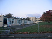 The main primary school for the area is Carden, built in the late 1940s and one of the first schools to be completed in the post-war period. Alderman Morris, then Mayor of Brighton, laid the foundation stone on 22 October 1947 and the first children attended on 3 September 1948. The school is built on a natural west-facing slope and was constructed in a revolutionary design using pre-cast concrete. The exterior remained unpainted grey textured concrete for many years. The classrooms all have doors which open out onto patio areas leading to the belief that the building was originally designed to be used as a hospital in the event of further hostilities. The original Carden Infants and Carden Junior schools merged in September 1999 to become Carden Primary School.
, Coldean
and Patcham
, occupies around 18 acre (0.07284348 km²; 0.0281250248673922 sq mi) and was developed by the local authority from 1950. The factories on the estate employed 8,000 local people at one time but most of the manufacturing companies had closed down or moved out by the 1980s when fewer than 1,000 people were employed. The area saw a revival in 1987 with the building of an Asda
superstore. Additional retail units followed in subsequent years and the area was further boosted when the offices and printing presses of the local newspaper The Argus
moved from the city centre onto the industrial estate.
routes 5B, 24, 26, 46, 55, 56 and 88 link the Hollingbury estate to the city centre and other outlying areas of the city.
The A27
provides access to the north of the estate, adjacent to the Asda superstore and the A23
access to the west via Patcham
.
The nearest railway stations are Preston Park on the Brighton Main Line
and London Road (Brighton)
on the East Coastway Line
.
East Sussex
East Sussex is a county in South East England. It is bordered by the counties of Kent, Surrey and West Sussex, and to the south by the English Channel.-History:...
. The area sits high on a hillside across the north of the city above Patcham
Patcham
Patcham is an area of the city of Brighton and Hove. It is approximately north of the city centre, bounded by the A27 to the north, Hollingbury to the east and southeast, Withdean to the south and the Brighton Main Line to the west...
which lies in a valley to the west, Coldean
Coldean
Coldean is a suburb of Brighton and Hove, England and is one of its most well defined and self contained. Unlike its neighbours Moulsecoomb or Hollingbury, it sits in a steep sided valley on the extreme north-east of the city...
in a valley to the east, and the A27
A27 road
The A27 is a major road in England. It runs from its junction with the A36 at Whiteparish in the county of Wiltshire. It closely parallels the south coast, where it passes through West Sussex and terminates at Pevensey in East Sussex.Between Portsmouth and Lewes, it is one of the busiest trunk...
bypass forming the northern limit. To the south it blends into leafy Surrenden and the busy Fiveways shopping area.
Hollingbury Hill itself reaches an elevation of 584 feet (178 m) above sea level and on the summit is Hollingbury Castle Camp, an Iron Age
Iron Age
The Iron Age is the archaeological period generally occurring after the Bronze Age, marked by the prevalent use of iron. The early period of the age is characterized by the widespread use of iron or steel. The adoption of such material coincided with other changes in society, including differing...
hill fort
Hill fort
A hill fort is a type of earthworks used as a fortified refuge or defended settlement, located to exploit a rise in elevation for defensive advantage. They are typically European and of the Bronze and Iron Ages. Some were used in the post-Roman period...
dating from around the sixth century B.C. It is where Triangulation Point
Triangulation station
A triangulation station, also known as a triangulation pillar, trigonometrical station, trigonometrical point, trig station, trig beacon or trig point, and sometimes informally as a trig, is a fixed surveying station, used in geodetic surveying and other surveying projects in its vicinity...
(or Trigpoint) TP3970 used for the 1936 Ordnance Survey
Ordnance Survey
Ordnance Survey , an executive agency and non-ministerial government department of the Government of the United Kingdom, is the national mapping agency for Great Britain, producing maps of Great Britain , and one of the world's largest producers of maps.The name reflects its creation together with...
mapping of Great Britain
Great Britain
Great Britain or Britain is an island situated to the northwest of Continental Europe. It is the ninth largest island in the world, and the largest European island, as well as the largest of the British Isles...
is located.
The north-western slopes of the hill have been developed and are populated with housing dating from the 1940s onwards with minor retail and industrial use.
Community facilities
Tennis court
A tennis court is where the game of tennis is played. It is a firm rectangular surface with a low net stretched across the center. The same surface can be used to play both doubles and singles.-Dimensions:...
s, a bowling green
Bowling green
A bowling green is a finely-laid, close-mown and rolled stretch of lawn for playing the game of lawn bowls.Before 1830, when Edwin Beard Budding invented the lawnmower, lawns were often kept cropped by grazing sheep on them...
and a children’s playground. For many years the park was known by locals as "The Rocket Park" on account of the rocket-shaped climbing frame in the playground but this was removed and the playground extended in the early 1980s. An area towards the northern end of the park is fenced off and contains a weather station and underground reservoir. On a clear day, the park offers views over the city to the English Channel.
Adjacent to the park is an area of woodland planted in the nineteenth century; the majority of this was destroyed in the Great Storm of October 1987
Great Storm of 1987
The Great Storm of 1987 occurred on the night of 15/16 October 1987, when an unusually strong weather system caused winds to hit much of southern England and northern France...
. The local council maintains an easy access trail through the woodland.
Carden Park, located towards the north-east of the estate between Carden school and the industrial estate, occupies approximately 12 acre (0.04856232 km²; 0.0187500165782614 sq mi) and was originally laid out in the 1950s. The original tennis courts and swings were lost during industrial development in 1968 and the park now contains a football pitch and play area for young children.
Community centre
Asda
Asda Stores Ltd is a British supermarket chain which retails food, clothing, general merchandise, toys and financial services. It also has a mobile telephone network, , Asda Mobile...
development in 1987, the company built a local community centre, known as Old Boat Corner Community Centre, situated in Carden Park which opened in April 1998. Today the centre is thriving and is very much open to local residents. The Community Centre has a members Social Club and there are lots of different groups running from the Centre including Sports Clubs, Over 60s Clubs, Toddler Groups and Drama Classes. Full details can be found on the website.
Medical centre
Library
Housing
The housing is divided by small parades of local shops which are located throughout the estate along with some public house
Public house
A public house, informally known as a pub, is a drinking establishment fundamental to the culture of Britain, Ireland, Australia and New Zealand. There are approximately 53,500 public houses in the United Kingdom. This number has been declining every year, so that nearly half of the smaller...
s.
The estate is the town's largest post-war (World War II) council estate and is built on land originally acquired by the council in November 1909.
Education
Commerce and industry
Hollingbury industrial estate, located in the north-east of the estate near the borders with StanmerStanmer
Stanmer is a small village on the eastern outskirts of Brighton, in East Sussex, England.-History:Stanmer village pond is surrounded by sarsen stones, which accounts for the place-name, Old English for 'stone pond'. The stones are not in their original situation, but have been gathered on the Downs...
, Coldean
Coldean
Coldean is a suburb of Brighton and Hove, England and is one of its most well defined and self contained. Unlike its neighbours Moulsecoomb or Hollingbury, it sits in a steep sided valley on the extreme north-east of the city...
and Patcham
Patcham
Patcham is an area of the city of Brighton and Hove. It is approximately north of the city centre, bounded by the A27 to the north, Hollingbury to the east and southeast, Withdean to the south and the Brighton Main Line to the west...
, occupies around 18 acre (0.07284348 km²; 0.0281250248673922 sq mi) and was developed by the local authority from 1950. The factories on the estate employed 8,000 local people at one time but most of the manufacturing companies had closed down or moved out by the 1980s when fewer than 1,000 people were employed. The area saw a revival in 1987 with the building of an Asda
Asda
Asda Stores Ltd is a British supermarket chain which retails food, clothing, general merchandise, toys and financial services. It also has a mobile telephone network, , Asda Mobile...
superstore. Additional retail units followed in subsequent years and the area was further boosted when the offices and printing presses of the local newspaper The Argus
The Argus (Brighton)
The Argus is a local newspaper based in Brighton and Hove in East Sussex, with editions serving the city of Brighton and Hove and the other parts of both East and West Sussex.-History:...
moved from the city centre onto the industrial estate.
Transport
Brighton & Hove Bus and Coach CompanyBrighton & Hove Bus and Coach Company
Brighton & Hove Bus and Coach Company operates almost all bus services in the city of Brighton and Hove in southern England. The company was established in 1884 as Brighton, Hove and Preston United Omnibus Company and has been part of the Go-Ahead Group since 1993.The company currently operates a...
routes 5B, 24, 26, 46, 55, 56 and 88 link the Hollingbury estate to the city centre and other outlying areas of the city.
The A27
A27 road
The A27 is a major road in England. It runs from its junction with the A36 at Whiteparish in the county of Wiltshire. It closely parallels the south coast, where it passes through West Sussex and terminates at Pevensey in East Sussex.Between Portsmouth and Lewes, it is one of the busiest trunk...
provides access to the north of the estate, adjacent to the Asda superstore and the A23
A23 road
The A23 road is a major road in the United Kingdom between London and Brighton, East Sussex. It became an arterial route following the construction of Westminster Bridge in 1750 and the consequent improvement of roads leading to the bridge south of the river by the Turnpike Trusts...
access to the west via Patcham
Patcham
Patcham is an area of the city of Brighton and Hove. It is approximately north of the city centre, bounded by the A27 to the north, Hollingbury to the east and southeast, Withdean to the south and the Brighton Main Line to the west...
.
The nearest railway stations are Preston Park on the Brighton Main Line
Brighton Main Line
The Brighton Main Line is a British railway line from London Victoria and London Bridge to Brighton. It is about 50 miles long, and is electrified throughout. Trains are operated by Southern, First Capital Connect, and Gatwick Express, now part of Southern.-Original proposals:There were no fewer...
and London Road (Brighton)
London Road (Brighton) railway station
London Road Railway Station is in Brighton, East Sussex, England. Train services from the station are provided by Southern, and the station is on the East Coastway Line.- History :...
on the East Coastway Line
East Coastway Line
East Coastway is the name used by the train operating company, Southern , for the routes it operates along the south coast of Sussex and Kent to the east of Brighton, England. Those to the West of Brighton are named the West Coastway Line...
.
Places of interest
- Hollingbury Camp, an Iron AgeIron AgeThe Iron Age is the archaeological period generally occurring after the Bronze Age, marked by the prevalent use of iron. The early period of the age is characterized by the widespread use of iron or steel. The adoption of such material coincided with other changes in society, including differing...
hillfort. - Hollingbury golfGolfGolf is a precision club and ball sport, in which competing players use many types of clubs to hit balls into a series of holes on a golf course using the fewest number of strokes....
course, a council-run course open to all.