

New England Flood of May 2006
Encyclopedia
Flood
A flood is an overflow of an expanse of water that submerges land. The EU Floods directive defines a flood as a temporary covering by water of land not normally covered by water...
event that occurred in New England
New England
New England is a region in the northeastern corner of the United States consisting of the six states of Maine, New Hampshire, Vermont, Massachusetts, Rhode Island, and Connecticut...
, especially in New Hampshire
New Hampshire
New Hampshire is a state in the New England region of the northeastern United States of America. The state was named after the southern English county of Hampshire. It is bordered by Massachusetts to the south, Vermont to the west, Maine and the Atlantic Ocean to the east, and the Canadian...
and Massachusetts
Massachusetts
The Commonwealth of Massachusetts is a state in the New England region of the northeastern United States of America. It is bordered by Rhode Island and Connecticut to the south, New York to the west, and Vermont and New Hampshire to the north; at its east lies the Atlantic Ocean. As of the 2010...
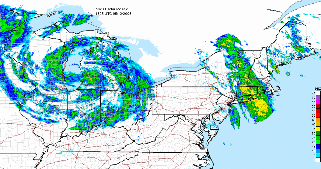
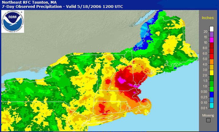
, during the month of May, 2006. It started on May 11, 2006 as a result of an unusually strong low pressure system that stalled over the central United States
United States
The United States of America is a federal constitutional republic comprising fifty states and a federal district...
, drawing copious amounts of moisture from the Atlantic Ocean
Atlantic Ocean
The Atlantic Ocean is the second-largest of the world's oceanic divisions. With a total area of about , it covers approximately 20% of the Earth's surface and about 26% of its water surface area...
. Most of this moisture was drawn directly over New England, producing continuous heavy rain that led to record flooding near several rivers. It was described as the worst flooding since the New England Hurricane of 1938
New England Hurricane of 1938
The New England Hurricane of 1938 was the first major hurricane to strike New England since 1869...
. There were no reports of injuries or fatalities. Some called it the Mother's Day Flood, since it occurred on that holiday
Mother's Day
Mother's Day is a celebration honoring mothers and celebrating motherhood, maternal bonds, and the influence of mothers in society. It is celebrated on various days in many parts of the world, yet most commonly in March, April, or May...
.
Impact
Merrimack River
The Merrimack River is a river in the northeastern United States. It rises at the confluence of the Pemigewasset and Winnipesaukee rivers in Franklin, New Hampshire, flows southward into Massachusetts, and then flows northeast until it empties into the Atlantic Ocean at Newburyport...
. Much of New England was under a flood warning
Flood watch
Flood alerts are issued by weather agencies to alert residents that flood conditions are a possibility for their area.-Types of flood alerts:...
or flash flood warning
Flash Flood Warning
A Flash Flood Warning is issued when a flash flood is imminent or occurring in the warned area. A flash flood is a sudden, violent flood after a heavy rain...
at some point in time.
The governors of Maine
Governor of Maine
The governor of Maine is the chief executive of the State of Maine. Before Maine was admitted to the Union in 1820, Maine was part of Massachusetts and the governor of Massachusetts was chief executive....
, Massachusetts
Governor of Massachusetts
The Governor of the Commonwealth of Massachusetts is the executive magistrate of the Commonwealth of Massachusetts, United States. The current governor is Democrat Deval Patrick.-Constitutional role:...
and New Hampshire
Governor of New Hampshire
The Governor of the State of New Hampshire is the supreme executive magistrate of the U.S. state of New Hampshire.The governor is elected at the biennial state general election in November of even-numbered years. New Hampshire is one of only two states, along with bordering Vermont, to hold...
each declared a state of emergency
State of emergency
A state of emergency is a governmental declaration that may suspend some normal functions of the executive, legislative and judicial powers, alert citizens to change their normal behaviours, or order government agencies to implement emergency preparedness plans. It can also be used as a rationale...
for all or part of their respective states as a result of the flooding.
Connecticut
Compared to farther north and east, the flooding was relatively minor in ConnecticutConnecticut
Connecticut is a state in the New England region of the northeastern United States. It is bordered by Rhode Island to the east, Massachusetts to the north, and the state of New York to the west and the south .Connecticut is named for the Connecticut River, the major U.S. river that approximately...
. It was most notable in low-lying areas along the Connecticut River
Connecticut River
The Connecticut River is the largest and longest river in New England, and also an American Heritage River. It flows roughly south, starting from the Fourth Connecticut Lake in New Hampshire. After flowing through the remaining Connecticut Lakes and Lake Francis, it defines the border between the...
.
Maine
Extreme southern MaineMaine
Maine is a state in the New England region of the northeastern United States, bordered by the Atlantic Ocean to the east and south, New Hampshire to the west, and the Canadian provinces of Quebec to the northwest and New Brunswick to the northeast. Maine is both the northernmost and easternmost...
saw significant flooding, especially around the Mousam River
Mousam River
The Mousam River is a river in Maine in the United States. Its source is Mousam Lake in York County, and it flows into the Atlantic Ocean just west of Kennebunk Beach. It flows through the towns of Sanford and Kennebunk.-External links:...
, where evacuations were underway as the river rose quickly. Downtown York Beach was underwater, and severe flooding was also reported in the Kennebunk
Kennebunk, Maine
Kennebunk is a town in York County, Maine, United States. The population was 1,075 people at the 2000 census. Including Kennebunkport , the population totals 14,196 people...
area.
The Spaulding Dam along the lower Salmon Falls River
Salmon Falls River
The Salmon Falls River is a tributary of the Piscataqua River in the U.S. states of Maine and New Hampshire. It rises at Great East Lake and flows south-southeast for approximately , forming the border between Maine and New Hampshire....
near Lebanon
Lebanon, Maine
Lebanon is a town in York County, Maine, United States. The population was 5,083 at the 2000 census. Lebanon includes the villages of Center Lebanon, West Lebanon, North Lebanon, South Lebanon and East Lebanon. It is part of the Portland–South Portland–Biddeford, Maine metropolitan...
was also in danger of bursting, which led to the evacuation of portions of the community.
Massachusetts
Numerous rivers overflowed in northeastern Massachusetts, and urban flooding also occurred. Thousands of people were evacuated and water was reported to be up to the rooftops of several homes. Several rivers, including the MerrimackMerrimack River
The Merrimack River is a river in the northeastern United States. It rises at the confluence of the Pemigewasset and Winnipesaukee rivers in Franklin, New Hampshire, flows southward into Massachusetts, and then flows northeast until it empties into the Atlantic Ocean at Newburyport...
and Charles
Charles River
The Charles River is an long river that flows in an overall northeasterly direction in eastern Massachusetts, USA. From its source in Hopkinton, the river travels through 22 cities and towns until reaching the Atlantic Ocean at Boston...
rivers, threatened several communities. The Merrimack in Lowell
Lowell, Massachusetts
Lowell is a city in Middlesex County, Massachusetts, USA. According to the 2010 census, the city's population was 106,519. It is the fourth largest city in the state. Lowell and Cambridge are the county seats of Middlesex County...
was expected to reach more than 8 feet (2.4 m) above flood stage combined with 15 inches (380 mm) of rain.
Haverhill, Massachusetts
Haverhill is a city in Essex County, Massachusetts, United States. The population was 60,879 at the 2010 census.Located on the Merrimack River, it began as a farming community that would evolve into an important industrial center, beginning with sawmills and gristmills run by water power. In the...
dumped 35 million gallons (132,000 m³) of waste a day into the Merrimack River
Merrimack River
The Merrimack River is a river in the northeastern United States. It rises at the confluence of the Pemigewasset and Winnipesaukee rivers in Franklin, New Hampshire, flows southward into Massachusetts, and then flows northeast until it empties into the Atlantic Ocean at Newburyport...
. In addition, the flooding at another regional treatment plant in Lawrence
Lawrence, Massachusetts
Lawrence is a city in Essex County, Massachusetts, United States on the Merrimack River. According to the 2010 U.S. Census, the city had a total population of 76,377. Surrounding communities include Methuen to the north, Andover to the southwest, and North Andover to the southeast. It and Salem are...
was also very close to shutting down the power there, which would have sent sewage into the Merrimack at a rate of 115 million gallons (435,000 m³) a day. For only the third time in a 150 year history, Lowell dropped its flood-controlling Francis Gate
James B. Francis
James Bicheno Francis was a British-American engineer, who invented the Francis turbine.-Early years:James Francis was born in South Leigh, near Witney, Oxfordshire in England, United Kingdom...
. Also, most notably in downtown Peabody
Peabody, Massachusetts
Peabody is a city in Essex County, Massachusetts, United States. The population is about 53,000. Peabody is located in Boston's North Shore suburban area.- History :...
, people could even be seen sailing in boats atop flooded areas.
Governor Mitt Romney
Mitt Romney
Willard Mitt Romney is an American businessman and politician. He was the 70th Governor of Massachusetts from 2003 to 2007 and is a candidate for the 2012 Republican Party presidential nomination.The son of George W...
toured the hard-hit community of Peabody on May 15 and described the situation as historic. "This is a level of crisis which is beyond anything these communities have ever experienced from water in their history". On Good Morning America
Good Morning America
Good Morning America is an American morning news and talk show that is broadcast on the ABC television network; it debuted on November 3, 1975. The weekday program airs for two hours; a third hour aired between 2007 and 2008 exclusively on ABC News Now...
the next day, Romney described the flooding as "almost Biblical" and said "We're sort of making jokes about Noah
Noah
Noah was, according to the Hebrew Bible, the tenth and last of the antediluvian Patriarchs. The biblical story of Noah is contained in chapters 6–9 of the book of Genesis, where he saves his family and representatives of all animals from the flood by constructing an ark...
and taking two of each kind of animal because we haven't ever seen rain like this."
Numerous roads, including a busy section of US 1
U.S. Route 1 in Massachusetts
In the U.S. state of Massachusetts, U.S. Route 1 is a major north–south state highway through Boston. The portion of US 1 south of Boston is also known as the Boston-Providence Turnpike, and portions north of the city are known as the Northeast Expressway and the Newburyport Turnpike.-Route...
, were closed due to flooding. The Route 495 exit at Route 114 was also closed, the entire area under several feet of water. At that area, several businesses were damaged, including a Friendlys, a 7-11 and the first floor of a hotel.
New Hampshire

Merrimack River
The Merrimack River is a river in the northeastern United States. It rises at the confluence of the Pemigewasset and Winnipesaukee rivers in Franklin, New Hampshire, flows southward into Massachusetts, and then flows northeast until it empties into the Atlantic Ocean at Newburyport...
. Dozens of homes were flooded, especially in Manchester
Manchester, New Hampshire
Manchester is the largest city in the U.S. state of New Hampshire, the tenth largest city in New England, and the largest city in northern New England, an area comprising the states of Maine, New Hampshire, and Vermont. It is in Hillsborough County along the banks of the Merrimack River, which...
where the Merrimack was 10 feet (3 m) above flood stage. Electricity was cut along several sections of the river, and flooding was reported in Concord
Concord, New Hampshire
The city of Concord is the capital of the state of New Hampshire in the United States. It is also the county seat of Merrimack County. As of the 2010 census, its population was 42,695....
, Merrimack
Merrimack, New Hampshire
Merrimack is a town in Hillsborough County, New Hampshire, United States. The population was 25,494 at the 2010 census, making it the eighth-largest municipality in New Hampshire....
, Hooksett
Hooksett, New Hampshire
Hooksett is a town in Merrimack County, New Hampshire, United States. The population was 13,451 at the 2010 census. The town is located between Manchester, the state's largest city, and Concord, the state capital...
, Fremont
Fremont, New Hampshire
Fremont is a town in Rockingham County, New Hampshire, United States. The population was 4,283 at the 2010 census. Fremont is crossed by the Rockingham Recreation Trail and NH Route 107.-History:...
and Raymond
Raymond, New Hampshire
Raymond is a town in Rockingham County, New Hampshire, United States. The population was 10,138 at the 2010 census. Part of Pawtuckaway State Park is in the north....
among other communities. At least 600 roads were closed due to flooding.
There were serious concerns along the Salmon Falls River
Salmon Falls River
The Salmon Falls River is a tributary of the Piscataqua River in the U.S. states of Maine and New Hampshire. It rises at Great East Lake and flows south-southeast for approximately , forming the border between Maine and New Hampshire....
in Milton
Milton, New Hampshire
Milton is a town in Strafford County, New Hampshire, United States. The population was 4,598 at the 2010 census. A manufacturing, resort and residential town, Milton includes the village of Milton Mills...
, where a dam was dangerously close to failing and causing extreme flooding downstream. Several other dams, including the Newmarket
Newmarket, New Hampshire
Newmarket is a town in Rockingham County, New Hampshire, United States. The population was 8,936 at the 2010 census. Some residents are students and employees at the nearby University of New Hampshire in Durham....
Dam on the Lamprey River
Lamprey River
The Lamprey River is a 50.2 mile long river in southeastern New Hampshire, the United States. It rises in Meadow Lake in Northwood, and flows south, then generally east past Raymond, Epping, Lee and finally Newmarket...
, were also being watched, with local residents being evacuated downstream.
In addition, at least 550 National Guard
United States National Guard
The National Guard of the United States is a reserve military force composed of state National Guard militia members or units under federally recognized active or inactive armed force service for the United States. Militia members are citizen soldiers, meaning they work part time for the National...
troops were deployed in the state. Damage in New Hampshire was estimated to be well into the tens of millions of dollars.
External links
- Hydrometeorological Prediction Center archive on this event.