
Hooksett, New Hampshire
Encyclopedia
Hooksett is a town in Merrimack County
, New Hampshire
, United States
. The population was 13,451 at the 2010 census. The town is located between Manchester
, the state's largest city, and Concord
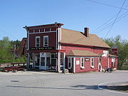
, the state capital. A prominent landmark is Robie's Country Store, a National Historic Landmark and a frequent stop for presidential candidates during the New Hampshire primary.
The central village in town, where 4,147 people resided at the 2010 census, is defined as the Hooksett census-designated place
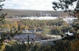
and is located at a bridge crossing of the Merrimack River
. The town also contains the census-designated place of South Hooksett
.
 Hooksett is situated on the Merrimack River in south-central New Hampshire. Interstate 93
connects Hooksett to the White Mountains
and Boston
. Hooksett lies fully within the Merrimack River watershed
.
According to the United States Census Bureau
, the town has a total area of 37.5 square miles (97.1 km²), of which 36.4 sq mi (94.3 km²) is land and 1 sq mi (2.6 km²) is water, comprising 2.71% of the town. Hooksett Village, a census-designated place
, has a total area of 5.1 sq mi (13.2 km²), of which 4.7 sq mi (12.2 km²) is land and 0.4 sq mi (1 km²) (7.80%) is water.
The highest point in Hooksett is Quimby Mountain, at 902 feet (274.9 m) above sea level
, near the town's western border. On the town's eastern border, a ridge ascending towards Hall Mountain in neighboring Candia
reaches 900 feet (274.3 m) above sea level.
 As of the census
of 2000, there were 11,721 people, 4,147 households, and 3,031 families residing in the town. The population density
was 323.6 people per square mile (124.9/km²). There were 4,307 housing units at an average density of 45.9 units/km² (118.9 units/sq mi). The racial makeup of the town was 96.45% White, 0.68% African American
, 0.24% Native American, 1.66% Asia
n, 0.03% Pacific Islander, 0.20% from other races, and 0.74% from two or more races. 1.45% of the population were Hispanic
or Latino
of any race.
There were 4,147 households out of which 36.2% had children under the age of 18 living with them, 60.6% were married couples
living together, 8.7% have a woman whose husband does not live with her, and 26.9% were non-families. 19.6% of all households were made up of individuals and 6.7% had someone living alone who was 65 years of age or older. The average household size was 2.63 and the average family size was 3.04.
In the town the population was spread out with 24.3% under the age of 18, 12.2% from 18 to 24, 32.1% from 25 to 44, 22.3% from 45 to 64, and 9.1% who were 65 years of age or older. The median age was 35 years. For every 100 females there were 99.9 males. For every 100 females age 18 and over, there were 97.7 males.
The median income for a household in the town was $61,491, and the median income for a family was $68,673. Males had a median income of $43,524 versus $31,341 for females. The per capita income
for the town was $24,629. 4.0% of the population and 3.2% of families were below the poverty line. Out of the total people living in poverty, 6.0% are under the age of 18 and 7.7% are 65 or older.
of 2000, there were 3,609 people, 1,484 households, and 1,020 families residing in the central village, or CDP
. The population density
was 762.7 people per square mile (294.6/km²). There were 1,547 housing units at an average density of 126.3 persons/km² (326.9 persons/sq mi). The racial makeup of the town was 96.34% White, 0.75% African American
, 0.28% Native American, 1.58% Asia
n, 0.28% from other races, and 0.78% from two or more races. 1.50% of the population were Hispanic
or Latino
of any race.
There were 1,484 households out of which 33.1% had children under the age of 18 living with them, 52.0% were married couples
living together, 12.5% have a woman whose husband does not live with her, and 31.2% were non-families. 24.1% of all households were made up of individuals and 5.9% had someone living alone who was 65 years of age or older. The average household size was 2.43 and the average family size was 2.88.
In the CDP the population was spread out with 25.1% under the age of 18, 4.8% from 18 to 24, 34.9% from 25 to 44, 25.5% from 45 to 64, and 9.7% who were 65 years of age or older. The median age was 38 years. For every 100 females there were 91.5 males. For every 100 females age 18 and over, there were 88.0 males.
The median income for a household in the village was $51,422, and the median income for a family was $56,786. Males had a median income of $40,106 versus $35,139 for females. The per capita income for is $23,933. 7.3% of the population and 7.1% of families were below the poverty line. Out of the total people living in poverty, 14.7% are under the age of 18 and 5.9% are 65 or older.
Merrimack County, New Hampshire
-Demographics:As of the census of 2000, there were 136,225 people, 51,843 households, and 35,460 families residing in the county. The population density was 146 people per square mile . There were 56,244 housing units at an average density of 60 per square mile...
, New Hampshire
New Hampshire
New Hampshire is a state in the New England region of the northeastern United States of America. The state was named after the southern English county of Hampshire. It is bordered by Massachusetts to the south, Vermont to the west, Maine and the Atlantic Ocean to the east, and the Canadian...
, United States
United States
The United States of America is a federal constitutional republic comprising fifty states and a federal district...
. The population was 13,451 at the 2010 census. The town is located between Manchester
Manchester, New Hampshire
Manchester is the largest city in the U.S. state of New Hampshire, the tenth largest city in New England, and the largest city in northern New England, an area comprising the states of Maine, New Hampshire, and Vermont. It is in Hillsborough County along the banks of the Merrimack River, which...
, the state's largest city, and Concord
Concord, New Hampshire
The city of Concord is the capital of the state of New Hampshire in the United States. It is also the county seat of Merrimack County. As of the 2010 census, its population was 42,695....
, the state capital. A prominent landmark is Robie's Country Store, a National Historic Landmark and a frequent stop for presidential candidates during the New Hampshire primary.
The central village in town, where 4,147 people resided at the 2010 census, is defined as the Hooksett census-designated place
Census-designated place
A census-designated place is a concentration of population identified by the United States Census Bureau for statistical purposes. CDPs are delineated for each decennial census as the statistical counterparts of incorporated places such as cities, towns and villages...
and is located at a bridge crossing of the Merrimack River
Merrimack River
The Merrimack River is a river in the northeastern United States. It rises at the confluence of the Pemigewasset and Winnipesaukee rivers in Franklin, New Hampshire, flows southward into Massachusetts, and then flows northeast until it empties into the Atlantic Ocean at Newburyport...
. The town also contains the census-designated place of South Hooksett
South Hooksett, New Hampshire
South Hooksett is a village and census-designated place within the town of Hooksett in Merrimack County, New Hampshire, United States. The population was 5,418 at the 2010 census....
.
History
Hooksett was incorporated in 1822. The first census, taken in 1830, reported 880 residents.Geography
Interstate 93
Interstate 93 is an Interstate Highway in the New England section of the United States. Its southern terminus is in Canton, Massachusetts, in the Boston metropolitan area, at Interstate 95; its northern terminus is near St. Johnsbury, Vermont, at Interstate 91...
connects Hooksett to the White Mountains
White Mountains (New Hampshire)
The White Mountains are a mountain range covering about a quarter of the state of New Hampshire and a small portion of western Maine in the United States. Part of the Appalachian Mountains, they are considered the most rugged mountains in New England...
and Boston
Boston
Boston is the capital of and largest city in Massachusetts, and is one of the oldest cities in the United States. The largest city in New England, Boston is regarded as the unofficial "Capital of New England" for its economic and cultural impact on the entire New England region. The city proper had...
. Hooksett lies fully within the Merrimack River watershed
Drainage basin
A drainage basin is an extent or an area of land where surface water from rain and melting snow or ice converges to a single point, usually the exit of the basin, where the waters join another waterbody, such as a river, lake, reservoir, estuary, wetland, sea, or ocean...
.
According to the United States Census Bureau
United States Census Bureau
The United States Census Bureau is the government agency that is responsible for the United States Census. It also gathers other national demographic and economic data...
, the town has a total area of 37.5 square miles (97.1 km²), of which 36.4 sq mi (94.3 km²) is land and 1 sq mi (2.6 km²) is water, comprising 2.71% of the town. Hooksett Village, a census-designated place
Census-designated place
A census-designated place is a concentration of population identified by the United States Census Bureau for statistical purposes. CDPs are delineated for each decennial census as the statistical counterparts of incorporated places such as cities, towns and villages...
, has a total area of 5.1 sq mi (13.2 km²), of which 4.7 sq mi (12.2 km²) is land and 0.4 sq mi (1 km²) (7.80%) is water.
The highest point in Hooksett is Quimby Mountain, at 902 feet (274.9 m) above sea level
Sea level
Mean sea level is a measure of the average height of the ocean's surface ; used as a standard in reckoning land elevation...
, near the town's western border. On the town's eastern border, a ridge ascending towards Hall Mountain in neighboring Candia
Candia, New Hampshire
Candia is a town in Rockingham County, New Hampshire, United States. The population was 3,909 at the 2010 census. The town includes the villages of Candia, Candia Four Corners and East Candia.-History:...
reaches 900 feet (274.3 m) above sea level.
Demographics
Census
A census is the procedure of systematically acquiring and recording information about the members of a given population. It is a regularly occurring and official count of a particular population. The term is used mostly in connection with national population and housing censuses; other common...
of 2000, there were 11,721 people, 4,147 households, and 3,031 families residing in the town. The population density
Population density
Population density is a measurement of population per unit area or unit volume. It is frequently applied to living organisms, and particularly to humans...
was 323.6 people per square mile (124.9/km²). There were 4,307 housing units at an average density of 45.9 units/km² (118.9 units/sq mi). The racial makeup of the town was 96.45% White, 0.68% African American
African American
African Americans are citizens or residents of the United States who have at least partial ancestry from any of the native populations of Sub-Saharan Africa and are the direct descendants of enslaved Africans within the boundaries of the present United States...
, 0.24% Native American, 1.66% Asia
Asia
Asia is the world's largest and most populous continent, located primarily in the eastern and northern hemispheres. It covers 8.7% of the Earth's total surface area and with approximately 3.879 billion people, it hosts 60% of the world's current human population...
n, 0.03% Pacific Islander, 0.20% from other races, and 0.74% from two or more races. 1.45% of the population were Hispanic
Hispanic
Hispanic is a term that originally denoted a relationship to Hispania, which is to say the Iberian Peninsula: Andorra, Gibraltar, Portugal and Spain. During the Modern Era, Hispanic sometimes takes on a more limited meaning, particularly in the United States, where the term means a person of ...
or Latino
Latino
The demonyms Latino and Latina , are defined in English language dictionaries as:* "a person of Latin-American descent."* "A Latin American."* "A person of Hispanic, especially Latin-American, descent, often one living in the United States."...
of any race.
There were 4,147 households out of which 36.2% had children under the age of 18 living with them, 60.6% were married couples
Marriage
Marriage is a social union or legal contract between people that creates kinship. It is an institution in which interpersonal relationships, usually intimate and sexual, are acknowledged in a variety of ways, depending on the culture or subculture in which it is found...
living together, 8.7% have a woman whose husband does not live with her, and 26.9% were non-families. 19.6% of all households were made up of individuals and 6.7% had someone living alone who was 65 years of age or older. The average household size was 2.63 and the average family size was 3.04.
In the town the population was spread out with 24.3% under the age of 18, 12.2% from 18 to 24, 32.1% from 25 to 44, 22.3% from 45 to 64, and 9.1% who were 65 years of age or older. The median age was 35 years. For every 100 females there were 99.9 males. For every 100 females age 18 and over, there were 97.7 males.
The median income for a household in the town was $61,491, and the median income for a family was $68,673. Males had a median income of $43,524 versus $31,341 for females. The per capita income
Per capita income
Per capita income or income per person is a measure of mean income within an economic aggregate, such as a country or city. It is calculated by taking a measure of all sources of income in the aggregate and dividing it by the total population...
for the town was $24,629. 4.0% of the population and 3.2% of families were below the poverty line. Out of the total people living in poverty, 6.0% are under the age of 18 and 7.7% are 65 or older.
Hooksett village
As of the censusCensus
A census is the procedure of systematically acquiring and recording information about the members of a given population. It is a regularly occurring and official count of a particular population. The term is used mostly in connection with national population and housing censuses; other common...
of 2000, there were 3,609 people, 1,484 households, and 1,020 families residing in the central village, or CDP
Census-designated place
A census-designated place is a concentration of population identified by the United States Census Bureau for statistical purposes. CDPs are delineated for each decennial census as the statistical counterparts of incorporated places such as cities, towns and villages...
. The population density
Population density
Population density is a measurement of population per unit area or unit volume. It is frequently applied to living organisms, and particularly to humans...
was 762.7 people per square mile (294.6/km²). There were 1,547 housing units at an average density of 126.3 persons/km² (326.9 persons/sq mi). The racial makeup of the town was 96.34% White, 0.75% African American
African American
African Americans are citizens or residents of the United States who have at least partial ancestry from any of the native populations of Sub-Saharan Africa and are the direct descendants of enslaved Africans within the boundaries of the present United States...
, 0.28% Native American, 1.58% Asia
Asia
Asia is the world's largest and most populous continent, located primarily in the eastern and northern hemispheres. It covers 8.7% of the Earth's total surface area and with approximately 3.879 billion people, it hosts 60% of the world's current human population...
n, 0.28% from other races, and 0.78% from two or more races. 1.50% of the population were Hispanic
Hispanic
Hispanic is a term that originally denoted a relationship to Hispania, which is to say the Iberian Peninsula: Andorra, Gibraltar, Portugal and Spain. During the Modern Era, Hispanic sometimes takes on a more limited meaning, particularly in the United States, where the term means a person of ...
or Latino
Latino
The demonyms Latino and Latina , are defined in English language dictionaries as:* "a person of Latin-American descent."* "A Latin American."* "A person of Hispanic, especially Latin-American, descent, often one living in the United States."...
of any race.
There were 1,484 households out of which 33.1% had children under the age of 18 living with them, 52.0% were married couples
Marriage
Marriage is a social union or legal contract between people that creates kinship. It is an institution in which interpersonal relationships, usually intimate and sexual, are acknowledged in a variety of ways, depending on the culture or subculture in which it is found...
living together, 12.5% have a woman whose husband does not live with her, and 31.2% were non-families. 24.1% of all households were made up of individuals and 5.9% had someone living alone who was 65 years of age or older. The average household size was 2.43 and the average family size was 2.88.
In the CDP the population was spread out with 25.1% under the age of 18, 4.8% from 18 to 24, 34.9% from 25 to 44, 25.5% from 45 to 64, and 9.7% who were 65 years of age or older. The median age was 38 years. For every 100 females there were 91.5 males. For every 100 females age 18 and over, there were 88.0 males.
The median income for a household in the village was $51,422, and the median income for a family was $56,786. Males had a median income of $40,106 versus $35,139 for females. The per capita income for is $23,933. 7.3% of the population and 7.1% of families were below the poverty line. Out of the total people living in poverty, 14.7% are under the age of 18 and 5.9% are 65 or older.