

Neighbourhoods in North Bay, Ontario
Encyclopedia
The Canadian
city of North Bay
, Ontario
, is divided into numerous neighbourhoods.
Some time between 1906 and 1918, Maude Emma Beach became the first school teacher for the brand new one room school house built on Feronia Road. This school house serviced the farming community of the area, and it was not uncommon for children to miss school during harvest and planting time.
and Jack Garland Airport. Hornell Heights is not financially affiliated with the municipality of North Bay and is Federal land, funded and taken care of through Federal tax dollars. Currently North Bay provides transit service and snow removal service to some areas of Hornell Heights. Mail sent to this area is to be addressed to Hornell Heights, Ontario.
.
. The neighbourhood is located between the escarpment and McKeown Avenue.
Thibeault Terrace is also the closest neighbourhood to the campuses of Canadore College
and Nipissing University
housing many students.
 West Ferris, formerly an independent township
, was surveyed in 1880, and named after James Marshall Ferris
, a member of the Legislative Assembly of Ontario
. It was amalgamated into the city in 1968.
The township was quite small in size, sandwiched between the City of North Bay on the north, the township of North Himsworth
on the south, East Ferris
on the east, and Lake Nipissing
on the west. The township consists of North Bay's southern suburbs, namely the community of West Ferris. The area also includes the neighbourhoods of Sunset Park, Marshall Park, Champlain Park, Thorncliff, Tweedsmuir and Nipissing Junction. The La Vase River bifurcates the township running from the east into Lake Nipissing, as does Highway 11
running north-south. The township is home to about 14,000 people.
, was first surveyed in 1883 and named for Ontario MPP Joseph Henry Widdifield
. It was amalgamated into the city in 1968, at the same time as West Ferris.
The pre-amalgamation boundary between North Bay and Widdifield extended along a line from Trout Lake
to Lake Nipissing
. The city's Lansdowne and Norwood Avenues, in the Gateway neighbourhood, marked part of the municipal boundary. The township also includes the smaller neighbourhoods of Cooks Mills, Feronia, Fricker, Hornell Heights, Lounsbury, Pinewood, Thibeault Terrace, Trout Mills and Wallace Heights.
A neighbourhood in the northeastern corner of the city, near Widdifield Forest Provincial Park, retains the Widdifield name. Widdifield Secondary School
is also the name of one of the city's main public high school
s.
The old Widdifield Fire Tower still stands on Tower Road with its cupola removed. It is now used as a radio tower for the O.P.P. In the winter of 1965 the tower was used in scenes from the old CBC tv show The Forest Rangers
.
Canada
Canada is a North American country consisting of ten provinces and three territories. Located in the northern part of the continent, it extends from the Atlantic Ocean in the east to the Pacific Ocean in the west, and northward into the Arctic Ocean...
city of North Bay
North Bay, Ontario
North Bay is a city in Northeastern Ontario, Canada. It is the seat of Nipissing District, and takes its name from its position on the shore of Lake Nipissing.-History:...
, Ontario
Ontario
Ontario is a province of Canada, located in east-central Canada. It is Canada's most populous province and second largest in total area. It is home to the nation's most populous city, Toronto, and the nation's capital, Ottawa....
, is divided into numerous neighbourhoods.
Downtown
North Bay's Downtown is located along the shore of Lake Nipissing, between the Gateway and Ferris neighbourhoods. The area is aligned southeast to northwest, and bounded roughly by Fisher Street, Memorial Drive, Algonquin Avenue and Fifth Avenue.Feronia
Feronia used to be a farming community with a school, general store and community centre. In 2005 Feronia is far less impressive, however still with a decent population scattered off the highway. There is still a community centre, which is mostly an ice rink and a swing set, and up off the highway slightly on Cemetery Road, you will find a cemetery that has been there since the early 1900's. Daly's Road, so named for the Daly family who had farms all along that road, Four Mile Lake Road and Feronia Road are predominantly the entrance points to Feronia off the highway.Some time between 1906 and 1918, Maude Emma Beach became the first school teacher for the brand new one room school house built on Feronia Road. This school house serviced the farming community of the area, and it was not uncommon for children to miss school during harvest and planting time.
Gateway
Gateway, one of the city's oldest residential neighbourhoods, is located immediately adjacent to the city's downtown core. The neighbourhood is centred on Algonquin Avenue.Hornell Heights
Hornell Heights is the primary residential and institutional cluster on the grounds of CFB North BayCFB North Bay
Canadian Forces Base North Bay, also CFB North Bay, is an air force base located at the City of North Bay, Ontario about north of Toronto. The base is subordinate to 1 Canadian Air Division, Winnipeg, Manitoba, and is the centre for North American Aerospace Defense Command operations in Canada,...
and Jack Garland Airport. Hornell Heights is not financially affiliated with the municipality of North Bay and is Federal land, funded and taken care of through Federal tax dollars. Currently North Bay provides transit service and snow removal service to some areas of Hornell Heights. Mail sent to this area is to be addressed to Hornell Heights, Ontario.
Pinewood
The Pinewood area, adjacent to Gateway, is roughly the area between Algonquin Avenue and Gormanville Road, Main West and Highway 17Highway 17 (Ontario)
King's Highway 17, more commonly known as Highway 17, is a provincially maintained highway and the primary route of the Trans-Canada Highway through the Canadian province of Ontario. It begins at the Manitoba border west of Kenora and ends south of Arnprior at the western terminus of Highway 417, ...
.
Thibeault Terrace
Thibeault Terrace is a residential neighbourhood located north of Highway 17 and west of the Algonquin Avenue segment of Highway 11Highway 11 (Ontario)
King's Highway 11 is a provincially maintained highway in the Canadian province of Ontario. At , it is the second longest highway in the province after Highway 17. Highway 11 begins at Highway 400 in Barrie, and arches through northern Ontario, around Lake Superior, to the Ontario–Minnesota border...
. The neighbourhood is located between the escarpment and McKeown Avenue.
Thibeault Terrace is also the closest neighbourhood to the campuses of Canadore College
Canadore College
Canadore College is a college of applied arts and technology located in North Bay, Ontario, Canada. It was founded in 1967 as a campus of Sudbury's Cambrian College, and became an independent institution in 1972...
and Nipissing University
Nipissing University
Nipissing University is a public liberal arts university located in North Bay, Ontario, Canada, on a site overlooking Lake Nipissing. The university's unique character is defined by its location in Northern Ontario, and a large and highly respected faculty of education...
housing many students.
Trout Lake Road
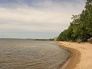
The residential neighbourhoods of St. John's Village, Eastview, Graniteville, Sage, Birchaven and Trout Mills extend northeasterly from the city core along Trout Lake Road.Birchaven
Birchaven1 is a neighbourhood located to the south of Trout Lake Road. Many people unfamiliar with this area and have incorrect maps mistakenly believe that it is called Birch Haven. Birchaven1 borders Trout Lake and extends to Wallace Road.West Ferris
Township (Canada)
The term township generally means the district or area associated with a town. However in some systems no town needs to be involved. The specific use of the term to describe political subdivisions has varied by country, usually to describe a local rural or semi-rural government within the county...
, was surveyed in 1880, and named after James Marshall Ferris
James Marshall Ferris
James Marshall Ferris was an Ontario political figure. He represented Northumberland East in the Legislative Assembly of Ontario as a Liberal member from 1875 to 1886....
, a member of the Legislative Assembly of Ontario
Legislative Assembly of Ontario
The Legislative Assembly of Ontario , is the legislature of the Canadian province of Ontario, and is the second largest provincial legislature of Canada...
. It was amalgamated into the city in 1968.
The township was quite small in size, sandwiched between the City of North Bay on the north, the township of North Himsworth
Callander, Ontario
The Municipality of Callander is a township in central Ontario, Canada, located at the southeast end of Lake Nipissing in the District of Parry Sound...
on the south, East Ferris
East Ferris, Ontario
East Ferris is a township in northeastern Ontario, Canada located between Trout Lake and Lake Nosbonsing in the District of Nipissing. West Ferris has long been annexed into the city of North Bay.-Communities:...
on the east, and Lake Nipissing
Lake Nipissing
Lake Nipissing is a lake in the Canadian province of Ontario. It has a surface area of , a mean elevation of above sea level, and is located between the Ottawa River and Georgian Bay. Excluding the Great Lakes, Lake Nipissing is the fifth-largest lake in Ontario. It is relatively shallow for a...
on the west. The township consists of North Bay's southern suburbs, namely the community of West Ferris. The area also includes the neighbourhoods of Sunset Park, Marshall Park, Champlain Park, Thorncliff, Tweedsmuir and Nipissing Junction. The La Vase River bifurcates the township running from the east into Lake Nipissing, as does Highway 11
Highway 11 (Ontario)
King's Highway 11 is a provincially maintained highway in the Canadian province of Ontario. At , it is the second longest highway in the province after Highway 17. Highway 11 begins at Highway 400 in Barrie, and arches through northern Ontario, around Lake Superior, to the Ontario–Minnesota border...
running north-south. The township is home to about 14,000 people.
Widdifield
Widdifield, formerly an independent townshipTownship (Canada)
The term township generally means the district or area associated with a town. However in some systems no town needs to be involved. The specific use of the term to describe political subdivisions has varied by country, usually to describe a local rural or semi-rural government within the county...
, was first surveyed in 1883 and named for Ontario MPP Joseph Henry Widdifield
Joseph Henry Widdifield
Joseph Henry Widdifield was an Ontario physician and political figure. He represented York North in the Legislative Assembly of Ontario as a Liberal member from 1875 to 1888....
. It was amalgamated into the city in 1968, at the same time as West Ferris.
The pre-amalgamation boundary between North Bay and Widdifield extended along a line from Trout Lake
Trout Lake (Ontario)
Trout Lake is a lake in municipalities of East Ferris and North Bay, Nipissing District in Northeastern Ontario, Canada, approximately east of the much larger Lake Nipissing. Trout Lake is the source of the Mattawa River and a significant body of water on a well-known historic North American...
to Lake Nipissing
Lake Nipissing
Lake Nipissing is a lake in the Canadian province of Ontario. It has a surface area of , a mean elevation of above sea level, and is located between the Ottawa River and Georgian Bay. Excluding the Great Lakes, Lake Nipissing is the fifth-largest lake in Ontario. It is relatively shallow for a...
. The city's Lansdowne and Norwood Avenues, in the Gateway neighbourhood, marked part of the municipal boundary. The township also includes the smaller neighbourhoods of Cooks Mills, Feronia, Fricker, Hornell Heights, Lounsbury, Pinewood, Thibeault Terrace, Trout Mills and Wallace Heights.
A neighbourhood in the northeastern corner of the city, near Widdifield Forest Provincial Park, retains the Widdifield name. Widdifield Secondary School
Widdifield Secondary School
Widdifield Secondary School is located along the Ski Club Road area of North Bay, Ontario. It is a member of the Near North District School Board.- Overview :...
is also the name of one of the city's main public high school
High school
High school is a term used in parts of the English speaking world to describe institutions which provide all or part of secondary education. The term is often incorporated into the name of such institutions....
s.
The old Widdifield Fire Tower still stands on Tower Road with its cupola removed. It is now used as a radio tower for the O.P.P. In the winter of 1965 the tower was used in scenes from the old CBC tv show The Forest Rangers
The Forest Rangers
The Forest Rangers was a Canadian television series that ran from 1963 to 1965. It was a co-production between CBC Television and ITC Entertainment and was Canada's first television show produced in colour...
.
Sources
- MapArt Ontario Road Atlas
- Statistics Canada
- Downtown North Bay
- Heritage Perspectives
- http://www.city.north-bay.on.ca/cityhall/department/transit/schedules.asp