
.gif)
Highway 11 (Ontario)
Encyclopedia
King's Highway 11 is a provincially maintained highway in the Canadian province of Ontario
. At 1780 kilometres (1,106 mi), it is the second longest highway in the province after Highway 17. Highway 11 begins at Highway 400 in Barrie
, and arches through northern Ontario, around Lake Superior
, to the Ontario–Minnesota
border at Rainy River
. The road continues as Minnesota State Highway 72
across the Baudette-Rainy River International Bridge
. Highway 11 is unique in that it is signed as a north-south route for approximately half its length, and as an east-west route thereafter.
North and west of North Bay
, Highway 11 forms part of the Trans-Canada Highway
. The highway is also part of MOM's Way
between Thunder Bay and Rainy River
.
 Highway 11 was originally planned as a trunk road to connect the communities of Southern Ontario
to those of Northern Ontario
, as a continuous route from Toronto to North Bay
. In 1919, Premier of Ontario
Ernest Charles Drury
created the Department of Public Highways
, though much of the responsibility for establishing the route, he left to Minister of the new cabinet position, Frank Campbell Biggs
. Most of the route linked previously built roads such as Yonge Street
, Penetanguishene Road, Middle Crossroad
and the Muskoka Road, all early colonization roads in this region.
Further expansion was planned with a new highway from North Bay to Cochrane
. Construction began in 1925, including reconstruction of portions of the old Muskoka Road from Severn Bridge
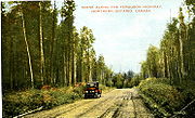
which was officially opened on July 2, 1927. When it was opened, it was named the Ferguson Highway
, in honour of Premier
George Howard Ferguson (Drury's successor). Roads in northern Ontario later came under the Ministry of Transportation and became provincial highways.
Over the years, Highway 11 grew to stretch from downtown Toronto all the way to the Minnesota border. Highway 11 became synonymous with Yonge Street
, the name of the street in Toronto which formed its southernmost segment. It is from this that Yonge Street gained a disputed reputation as the "longest street in the world".
In 1997, the care of the highway portion south of Barrie, including Yonge Street, was transferred by the provincial government to various regional governments as part of significant cost reductions by the Ministry of Transportation of Ontario. This practice is called downloading, in that the financial burden will fall to a lower tier government, in the premise of reducing taxes. Along with the name Yonge Street, the section in York Region is now York Regional Road 1, the section in Simcoe County is now mostly Simcoe County 4. Within the city of Toronto, which does not have a regional road numbering system, it is now known simply as Yonge Street. Highway 11 consequently assumed the 1.1-kilometre highway stub formerly known as Highway 400A, and now ends at the interchange with Highway 400 just north of Barrie's city limits.
In 2003, a major bridge failure at the Sgt. Aubrey Cosens VC Memorial Bridge
at the Montreal River
in Latchford
caused a complete closure and significant detour.
Major reconstruction of Highway 11 south of North Bay has taken place in recent years, upgrading the route from a two-lane rural highway to a four-lane road. In some sections the route is being built as an expressway
with right-in/right-out ramps or at-grade intersections, while in others it is being built as a full 400-Series
freeway. By the early-2010s, it is expected that all of the highway between Gravenhurst
and North Bay
will be four lanes. Despite the at-grade intersections, the normal freeway speed of 100 kilometres per hour (62 mph) is posted.
Highway 11 crosses the 45th parallel (halfway between the equator and north pole) 600 metres north of the bridge carrying Highway 118 at interchange 182, just outside of Bracebridge
.
Due to a steep incline as it descends Thibeault Hill into North Bay, the southbound Algonquin Avenue segment of Highway 11 features the only runaway truck ramp
on Ontario's highway system. The Ministry of Transportation is currently undertaking a study of potential highway improvements in the North Bay area, which may include a new westerly realignment of this segment to bypass the hill.
s of Highway 11, nine of which have existed over the years. Two continue to exist today, while the remaining seven have been decommissioned. With the exception of the short spur route into Atikokan, all were at one time the primary route of Highway 11 through the communities they served, and were redesignated as 11B after a newer bypass
alignment was constructed.
 All sections of Highway 11B have now been decommissioned by the province with the exception of the Atikokan route and the southernmost section of the former Tri-Town route between Cobalt and Highway 11.
In 1967, a section of the Cobalt route of Highway 11B collapsed into an abandoned mine, cutting off the town of Cobalt
.
is currently a rather unusual right-in/right-out
(RIRO) expressway (local access permitted, turnarounds via special interchanges), except for a section around Orillia which is a full freeway. Another freeway section does exist in Barrie with the freeway segment from the southern terminus ending at Penetanguishene Road (Simcoe Road 93). The MTO is currently planning on either converting the existing RIRO expressway to a full six-lane freeway, or bypassing it with an entirely new alignment. An environmental and fiscal study concluded that the improvements from Barrie to Gravenhurst will involve the existing route being widened with the exception of a portion south of Gravenhurst that may potentially be constructed to the east of the current road.
North of Gravenhurst to North Bay, the highway is a mixture of freeway sections and at-grade rural expressway (planned to be upgraded to a full freeway) except for one gap that remains a two-lane conventional highway; that section is expected to be widened by 2012.
Ontario
Ontario is a province of Canada, located in east-central Canada. It is Canada's most populous province and second largest in total area. It is home to the nation's most populous city, Toronto, and the nation's capital, Ottawa....
. At 1780 kilometres (1,106 mi), it is the second longest highway in the province after Highway 17. Highway 11 begins at Highway 400 in Barrie
Barrie
Barrie may refer to:* Barrie, city in Ontario, Canada* Barrie , Canadian federal electoral district* Barrie , provincial electoral district* Barrie—Simcoe—Bradford, former Canadian electoral district...
, and arches through northern Ontario, around Lake Superior
Lake Superior
Lake Superior is the largest of the five traditionally-demarcated Great Lakes of North America. It is bounded to the north by the Canadian province of Ontario and the U.S. state of Minnesota, and to the south by the U.S. states of Wisconsin and Michigan. It is the largest freshwater lake in the...
, to the Ontario–Minnesota
Minnesota
Minnesota is a U.S. state located in the Midwestern United States. The twelfth largest state of the U.S., it is the twenty-first most populous, with 5.3 million residents. Minnesota was carved out of the eastern half of the Minnesota Territory and admitted to the Union as the thirty-second state...
border at Rainy River
Rainy River, Ontario
The Canadian town of Rainy River is situated on the Ontario-Minnesota border, along the Rainy River opposite Baudette, Minnesota, USA, and southeast of the Lake of the Woods...
. The road continues as Minnesota State Highway 72
Minnesota State Highway 72
Minnesota State Highway 72 is a highway in northwest Minnesota, which runs from its intersection with U.S. 71 in Blackduck and continues north to its northern terminus at the Canadian border in Baudette...
across the Baudette-Rainy River International Bridge
Baudette-Rainy River International Bridge
The Baudette – Rainy River International Bridge is an international bridge connecting Rainy River, Ontario, Canada with Baudette, Minnesota, USA across the Rainy River....
. Highway 11 is unique in that it is signed as a north-south route for approximately half its length, and as an east-west route thereafter.
North and west of North Bay
North Bay, Ontario
North Bay is a city in Northeastern Ontario, Canada. It is the seat of Nipissing District, and takes its name from its position on the shore of Lake Nipissing.-History:...
, Highway 11 forms part of the Trans-Canada Highway
Trans-Canada Highway
The Trans-Canada Highway is a federal-provincial highway system that joins the ten provinces of Canada. It is, along with the Trans-Siberian Highway and Australia's Highway 1, one of the world's longest national highways, with the main route spanning 8,030 km...
. The highway is also part of MOM's Way
Mom's Way
MOM's Way is the name for a series of highways in the Canadian provinces of Ontario and Manitoba, and the U.S. state of Minnesota. The name "MOM" is an acronym for Manitoba, Ontario, and Minnesota, the two provinces and one state traversed by this multi-highway route.The roads included along the...
between Thunder Bay and Rainy River
Rainy River, Ontario
The Canadian town of Rainy River is situated on the Ontario-Minnesota border, along the Rainy River opposite Baudette, Minnesota, USA, and southeast of the Lake of the Woods...
.
History
Southern Ontario
Southern Ontario is a region of the province of Ontario, Canada that lies south of the French River and Algonquin Park. Depending on the inclusion of the Parry Sound and Muskoka districts, its surface area would cover between 14 to 15% of the province. It is the southernmost region of...
to those of Northern Ontario
Northern Ontario
Northern Ontario is a region of the Canadian province of Ontario which lies north of Lake Huron , the French River and Lake Nipissing. The region has a land area of 802,000 km2 and constitutes 87% of the land area of Ontario, although it contains only about 6% of the population...
, as a continuous route from Toronto to North Bay
North Bay, Ontario
North Bay is a city in Northeastern Ontario, Canada. It is the seat of Nipissing District, and takes its name from its position on the shore of Lake Nipissing.-History:...
. In 1919, Premier of Ontario
Premier of Ontario
The Premier of Ontario is the first Minister of the Crown for the Canadian province of Ontario. The Premier is appointed as the province's head of government by the Lieutenant Governor of Ontario, and presides over the Executive council, or Cabinet. The Executive Council Act The Premier of Ontario...
Ernest Charles Drury
Ernest Charles Drury
Ernest Charles Drury was a farmer, politician and writer who served as the eighth Premier of Ontario, Canada, from 1919 to 1923 as the head of a United Farmers of Ontario - Labour coalition government.-Family:...
created the Department of Public Highways
Ministry of Transportation (Ontario)
The Ministry of Transportation of Ontario is the provincial ministry of the government of Ontario which is responsible for transport infrastructure and related law in Ontario. The ministry traces its roots back over a century to the 1890s, when the province began training Provincial Road Building...
, though much of the responsibility for establishing the route, he left to Minister of the new cabinet position, Frank Campbell Biggs
Frank Campbell Biggs
Frank Campbell Biggs was a United Farmers member of the Legislative Assembly of Ontario who represented Wentworth North from 1919 to 1926...
. Most of the route linked previously built roads such as Yonge Street
Yonge Street
Yonge Street is a major arterial route connecting the shores of Lake Ontario in Toronto to Lake Simcoe, a gateway to the Upper Great Lakes. It was formerly listed in the Guinness Book of Records as the longest street in the world at , and the construction of Yonge Street is designated an "Event of...
, Penetanguishene Road, Middle Crossroad
Middle Crossroad (Simcoe County)
Middle Crossroad in the township of Oro-Medonte in Simcoe County, Ontario was a pioneer colonization road and now carries the traffic of Highway 11 north of Barrie, between the Crown Hill interchange and the City of Orillia....
and the Muskoka Road, all early colonization roads in this region.
Further expansion was planned with a new highway from North Bay to Cochrane
Cochrane, Ontario
Cochrane is a town in northern Ontario, Canada. It is located east of Kapuskasing, northeast of Timmins, south of Moosonee, and north of Iroquois Falls. It is about a one-hour drive from Timmins, the major city of the region. It is the seat of Cochrane District...
. Construction began in 1925, including reconstruction of portions of the old Muskoka Road from Severn Bridge
Severn Bridge, Ontario
Severn Bridge, Ontario is a small community in the Town of Gravenhurst, Ontario of the District of Muskoka in the province of Ontario, Canada. It is located around 100 kilometres north of Toronto, on the Severn River, roughly halfway between Orillia and Gravenhurst. Its population is around 300 ....
which was officially opened on July 2, 1927. When it was opened, it was named the Ferguson Highway
Ferguson Highway
The Ferguson Highway was a long gravel trunk road in Ontario, Canada. Built between 1925-1927 from the city of North Bay to the town of Cochrane, it was created to connect the growing agricultural and mining communities of Northern Ontario with other areas further south.Several sections of rebuilt...
, in honour of Premier
Premier of Ontario
The Premier of Ontario is the first Minister of the Crown for the Canadian province of Ontario. The Premier is appointed as the province's head of government by the Lieutenant Governor of Ontario, and presides over the Executive council, or Cabinet. The Executive Council Act The Premier of Ontario...
George Howard Ferguson (Drury's successor). Roads in northern Ontario later came under the Ministry of Transportation and became provincial highways.
Over the years, Highway 11 grew to stretch from downtown Toronto all the way to the Minnesota border. Highway 11 became synonymous with Yonge Street
Yonge Street
Yonge Street is a major arterial route connecting the shores of Lake Ontario in Toronto to Lake Simcoe, a gateway to the Upper Great Lakes. It was formerly listed in the Guinness Book of Records as the longest street in the world at , and the construction of Yonge Street is designated an "Event of...
, the name of the street in Toronto which formed its southernmost segment. It is from this that Yonge Street gained a disputed reputation as the "longest street in the world".
In 1997, the care of the highway portion south of Barrie, including Yonge Street, was transferred by the provincial government to various regional governments as part of significant cost reductions by the Ministry of Transportation of Ontario. This practice is called downloading, in that the financial burden will fall to a lower tier government, in the premise of reducing taxes. Along with the name Yonge Street, the section in York Region is now York Regional Road 1, the section in Simcoe County is now mostly Simcoe County 4. Within the city of Toronto, which does not have a regional road numbering system, it is now known simply as Yonge Street. Highway 11 consequently assumed the 1.1-kilometre highway stub formerly known as Highway 400A, and now ends at the interchange with Highway 400 just north of Barrie's city limits.
In 2003, a major bridge failure at the Sgt. Aubrey Cosens VC Memorial Bridge
Sgt. Aubrey Cosens VC Memorial Bridge
The Sgt. Aubrey Cosens VC Memorial Bridge is named after Sgt. Aubrey Cosens VC, and is located in Latchford, Ontario where Highway 11 crosses the Montreal River....
at the Montreal River
Montreal River (Timiskaming District, Ontario)
The Montreal River is a river in Timiskaming District, Ontario, Canada. It travels from its source at Smoothwater Lake to its mouth at Lake Timiskaming on the Ottawa River. The river is a significant source of hydroelectricity.-Course:...
in Latchford
Latchford, Ontario
Latchford is a Single-tier municipality town in Timiskaming District in Northeastern Ontario, Canada. It is located on Bay Lake on the Montreal River near the town of Cobalt and the municipality of Temagami, and is 20 kilometres from the city of Temiskaming Shores. The population of the town in...
caused a complete closure and significant detour.
Major reconstruction of Highway 11 south of North Bay has taken place in recent years, upgrading the route from a two-lane rural highway to a four-lane road. In some sections the route is being built as an expressway
Limited-access road
A limited-access road known by various terms worldwide, including limited-access highway, dual-carriageway and expressway, is a highway or arterial road for high-speed traffic which has many or most characteristics of a controlled-access highway , including limited or no access to adjacent...
with right-in/right-out ramps or at-grade intersections, while in others it is being built as a full 400-Series
400-series highways (Ontario)
The 400-series highways are a network of controlled-access highways throughout the southern portion of the Canadian province of Ontario, forming a special subset of the provincial highway system. They are analogous to the Interstate Highway System in the United States or the British Motorway...
freeway. By the early-2010s, it is expected that all of the highway between Gravenhurst
Gravenhurst, Ontario
Gravenhurst is a town in the Muskoka Region of Ontario, Canada. It is located approximately south of Bracebridge, Ontario. The mayor is Paisley Donaldson...
and North Bay
North Bay, Ontario
North Bay is a city in Northeastern Ontario, Canada. It is the seat of Nipissing District, and takes its name from its position on the shore of Lake Nipissing.-History:...
will be four lanes. Despite the at-grade intersections, the normal freeway speed of 100 kilometres per hour (62 mph) is posted.
Highway 11 crosses the 45th parallel (halfway between the equator and north pole) 600 metres north of the bridge carrying Highway 118 at interchange 182, just outside of Bracebridge
Bracebridge, Ontario
Bracebridge is a town and the seat of the Muskoka District Municipality of Ontario, Canada.The town was built around a waterfall on the Muskoka River in the centre of town, and is known for its other nearby waterfalls . It was first incorporated in 1875...
.
Due to a steep incline as it descends Thibeault Hill into North Bay, the southbound Algonquin Avenue segment of Highway 11 features the only runaway truck ramp
Runaway truck ramp
A runaway truck ramp, runaway truck lane, emergency escape ramp or truck arrester bed is a traffic device that enables vehicles that are having braking problems to safely stop. It is typically a long, sand or gravel-filled lane adjacent to a road with a steep grade, and is designed to accommodate...
on Ontario's highway system. The Ministry of Transportation is currently undertaking a study of potential highway improvements in the North Bay area, which may include a new westerly realignment of this segment to bypass the hill.
Business routes
Highway 11B is the designation for business routeBusiness route
A business route in the United States and Canada is a short special route connected to a parent numbered highway at its beginning, then routed through the central business district of a nearby city or town, and finally reconnecting with the same parent numbered highway again at its...
s of Highway 11, nine of which have existed over the years. Two continue to exist today, while the remaining seven have been decommissioned. With the exception of the short spur route into Atikokan, all were at one time the primary route of Highway 11 through the communities they served, and were redesignated as 11B after a newer bypass
Bypass (road)
A bypass is a road or highway that avoids or "bypasses" a built-up area, town, or village, to let through traffic flow without interference from local traffic, to reduce congestion in the built-up area, and to improve road safety....
alignment was constructed.
In 1967, a section of the Cobalt route of Highway 11B collapsed into an abandoned mine, cutting off the town of Cobalt
Cobalt, Ontario
Cobalt is a town in the district of Timiskaming, province of Ontario, Canada, with a population of 1,223 In 2001 Cobalt was named "Ontario's Most Historic Town" by a panel of judges on the TV Ontario program Studio 2, and in 2002 the area was designated a National Historic Site.-History:Silver was...
.
- Holland LandingHolland Landing, OntarioHolland Landing is a village in the town of East Gwillimbury, located in the northern part of the Regional Municipality of York, in south-central Ontario, Canada. Its major road is Yonge Street and the village has bus service by GO Transit and York Region Transit...
- Orillia
- GravenhurstGravenhurst, OntarioGravenhurst is a town in the Muskoka Region of Ontario, Canada. It is located approximately south of Bracebridge, Ontario. The mayor is Paisley Donaldson...
- HuntsvilleHuntsville, OntarioHuntsville is a town in the Muskoka Region of Ontario, Canada. It is located north of Toronto and south of North Bay....
- PowassanPowassan, OntarioPowassan is a municipality in the Canadian province of Ontario, located near North Bay. Powassan is located in the Parry Sound District, at its easternmost boundary with the Nipissing District....
- North BayNorth Bay, OntarioNorth Bay is a city in Northeastern Ontario, Canada. It is the seat of Nipissing District, and takes its name from its position on the shore of Lake Nipissing.-History:...
- CobaltCobalt, OntarioCobalt is a town in the district of Timiskaming, province of Ontario, Canada, with a population of 1,223 In 2001 Cobalt was named "Ontario's Most Historic Town" by a panel of judges on the TV Ontario program Studio 2, and in 2002 the area was designated a National Historic Site.-History:Silver was...
/Temiskaming Shores - Thunder BayThunder Bay-In Canada:Thunder Bay is the name of three places in the province of Ontario, Canada along Lake Superior:*Thunder Bay District, Ontario, a district in Northwestern Ontario*Thunder Bay, a city in Thunder Bay District*Thunder Bay, Unorganized, Ontario...
- Atikokan
Future
Highway 11 between Barrie and GravenhurstGravenhurst, Ontario
Gravenhurst is a town in the Muskoka Region of Ontario, Canada. It is located approximately south of Bracebridge, Ontario. The mayor is Paisley Donaldson...
is currently a rather unusual right-in/right-out
Right-in/right-out
Right-in/right-out and left-in/left-out refer to a type of road intersection where turning movements of vehicles are restricted. A RIRO permits only right turns and a LILO permits only left turns. RIRO is usual where vehicles drive on the right, and LILO is usual where vehicles drive on the left...
(RIRO) expressway (local access permitted, turnarounds via special interchanges), except for a section around Orillia which is a full freeway. Another freeway section does exist in Barrie with the freeway segment from the southern terminus ending at Penetanguishene Road (Simcoe Road 93). The MTO is currently planning on either converting the existing RIRO expressway to a full six-lane freeway, or bypassing it with an entirely new alignment. An environmental and fiscal study concluded that the improvements from Barrie to Gravenhurst will involve the existing route being widened with the exception of a portion south of Gravenhurst that may potentially be constructed to the east of the current road.
North of Gravenhurst to North Bay, the highway is a mixture of freeway sections and at-grade rural expressway (planned to be upgraded to a full freeway) except for one gap that remains a two-lane conventional highway; that section is expected to be widened by 2012.
Major intersections
Note the exit numbers start around 105 – currently the first posted exit number is 130 in Orillia – presumably for continuation from Highway 400.| Municipality | Exit number | Intersecting roads |
|---|---|---|
| Springwater Springwater, Ontario Springwater is a township in central Ontario, Canada, in Simcoe County near Barrie. It includes the former townships of Flos and Vespra. Springwater is the County seat of Simcoe.-Communities:... |
104* |  Highway 400 Highway 400 |
| Crown Hill (Springwater – Oro-Medonte Oro-Medonte, Ontario Oro-Medonte is a township in south-central Ontario, Canada on the northwestern shores of Lake Simcoe in Simcoe County.The two neighbouring townships of Oro and Medonte were merged together in 1994, under a restructuring of Simcoe County. It is divided into lines based on the concession system... Boundary) |
105* | Penetanguishene Road (Simcoe County Road 93; former  ) ) |
| Oro-Medonte | 109** | Oro-Medonte Line 3 (Simcoe County Road 57)/"Gasoline Alley" |
| Oro-Medonte | 115** | Oro-Medonte Line 7 (Simcoe County Road 127) |
| Oro-Medonte | 121** | Oro-Medonte Line 11 (Simcoe County Road 20) |
| Oro-Medonte – Orillia Boundary | 129 | Memorial Avenue (Simcoe County Road 49) (currently northbound only) |
| Orillia | 131 |  Highway 12 Highway 12Highway 12 (Ontario) King's Highway 12, commonly referred to as Highway 12, is a provincially maintained highway in the Canadian province of Ontario. The highway connects the eastern end of the Greater Toronto Area with Kawartha Lakes , Orillia and Midland. It forms a part of the Trans-Canada Highway system from north... South / Old Barrie Road (Simcoe County Road 11) |
| Orillia | 133 | Highway 12 Highway 12 (Ontario) King's Highway 12, commonly referred to as Highway 12, is a provincially maintained highway in the Canadian province of Ontario. The highway connects the eastern end of the Greater Toronto Area with Kawartha Lakes , Orillia and Midland. It forms a part of the Trans-Canada Highway system from north... North / Coldwater Road |
| Orillia – Severn Severn, Ontario Severn is a township in south-central Ontario, Canada, located between Lake Couchiching, and the Severn River in Simcoe County... Boundary |
135 | Burnside Line/West Street (Simcoe County Road 18) |
| Orillia – Severn Boundary | 137* | Laclie Street |
| Severn | 146** | South Sparrow Lake Road (Simcoe County Road 38)/Goldstein Road |
| Severn | 151** | Simcoe County Road 169 (formerly Ontario Highways  69 69Ontario Highway 69 King's Highway 69, commonly referred to as Highway 69, is a major north–south highway in the central area of the Canadian province of Ontario, linking Highway 400 north of Parry Sound with Sudbury... and 169 Highway 169 (Ontario) King's Highway 169, commonly referred to as Highway 169, was a provincially maintained highway in the Canadian province of Ontario. The highway connected Highway 69 at Foot's Bay with Highway 12 southeast of Orillia... ) |
| Severn – Gravenhurst Gravenhurst, Ontario Gravenhurst is a town in the Muskoka Region of Ontario, Canada. It is located approximately south of Bracebridge, Ontario. The mayor is Paisley Donaldson... Boundary |
153** | Coopers Falls Road (Muskoka Road 6 and Simcoe County Road 52) |
| Gravenhurst | 154** | Southwood Road (Muskoka Road 13) |
| Gravenhurst | 161** | Kilworthy Road/Kahshe Lake Road |
| Gravenhurst | 169 | Muskoka Road 169 (formerly Ontario Highways 69 Ontario Highway 69 King's Highway 69, commonly referred to as Highway 69, is a major north–south highway in the central area of the Canadian province of Ontario, linking Highway 400 north of Parry Sound with Sudbury... and 169 Highway 169 (Ontario) King's Highway 169, commonly referred to as Highway 169, was a provincially maintained highway in the Canadian province of Ontario. The highway connected Highway 69 at Foot's Bay with Highway 12 southeast of Orillia... ) |
| Gravenhurst | 175 | Bethune Drive (Muskoka Road 41)/Doe Lake Road (Muskoka Road 6) |
| Bracebridge Bracebridge, Ontario Bracebridge is a town and the seat of the Muskoka District Municipality of Ontario, Canada.The town was built around a waterfall on the Muskoka River in the centre of town, and is known for its other nearby waterfalls . It was first incorporated in 1875... |
182 | Highway 118 Highway 118 (Ontario) King's Highway 118, commonly referred to as Highway 118, is a provincially maintained highway in the Canadian province of Ontario. The route travels across South-Central Ontario between Highway 11 near Bracebridge and Highway 28 near Bancroft... /Muskoka Road 118 West |
| Bracebridge | 184 | Cedar Lane (Muskoka Road 37) |
| Bracebridge | 189 | Taylor Road (Muskoka Road 42) |
| Bracebridge | 191* | Kirk Line (substandard) |
| Bracebridge | 193 | Muskoka Road 117 (formerly Highway 117) |
| Huntsville Huntsville, Ontario Huntsville is a town in the Muskoka Region of Ontario, Canada. It is located north of Toronto and south of North Bay.... |
205* | South Mary Lake Road (Muskoka Road 44)/Stephenson Road 4 (at-grade intersection, interchange construction to begin soon) |
| Huntsville | 207 |  Highway 141 Highway 141Highway 141 (Ontario) King's Highway 141, commonly known as Highway 141, is a provincially maintained highway in the Canadian province of Ontario. Its western terminus is at Highway 400 south of Horseshoe Lake in Seguin Township while its eastern terminus is at Highway 11 near Port Sydney... /Port Sydney Road (Muskoka Road 10) |
| Huntsville | 212* | Allensville Road/Rowanwood Road (currently an at-grade intersection) |
| Huntsville | 216* | Gryffin Lodge Road/Madill Church Road (currently an at-grade intersection) |
| Huntsville | 219 | Muskoka Road 3 |
| Huntsville | 221 | Muskoka Road 2 |
| Huntsville | 223 |  Highway 60 Highway 60Highway 60 (Ontario) King's Highway 60, commonly referred to as Highway 60, is a provincially maintained highway in the Canadian province of Ontario. The highway serves as the primary corridor through Algonquin Provincial Park, where it is dedicated as the Frank McDougall Parkway. East of Algonquin Park, the route... |
| Huntsville | 226 | Muskoka Road 3/Old North Road |
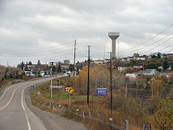
| Huntsville | 231 | North Waseosa Lake Road/Rockhaven Road (pictured below) |
| Huntsville – Perry Perry, Ontario Perry is a township in the Canadian province of Ontario, located in the Parry Sound District.The township had a population of 2,252 in the 2001 Canadian census.-Demographics:Population trend:... Boundary |
235 | Novar Road/ Highway 592 |
| Perry | 244 | Fern Glen Road/Scotia Road |
| Perry | 248 | Highway 518 Highway 518 (Ontario) Secondary Highway 518, commonly referred to as Highway 518, is a provincially maintained secondary highway in the Canadian province of Ontario. Highway 518 spans between Parry Sound and Kearney. It serves as one of the many links between Highway 400 and Highway 11... /Deer Lake Road |
| Armour Armour, Ontario Armour is a township in the Canadian province of Ontario.Located in the Parry Sound District, the township surrounds but does not include the village of Burk's Falls... |
252* | Doe Lake Road/Three Mile Lake Road (at-grade intersection, interchange under construction) |
| Armour | 257* | Highway 520 Highway 520 (Ontario) Secondary Highway 520, commonly referred to as Highway 520, is a provincially maintained highway in the Canadian province of Ontario. The highway is in length, connecting several small communities in Parry Sound District with Highway 124 and Highway 11.... /Ferguson Road (at-grade intersection, interchange under construction) |
| Armour | 261* | Ontario Street (at-grade intersection, future interchange) |
| Armour – Strong Strong, Ontario Strong is a township in the Canadian province of Ontario, as well as the name of a community within the township. Located in the Parry Sound District, the township surrounds but does not include the village of Sundridge.... Boundary |
266* | Pevensey Road (at-grade intersection, future interchange) |
| Strong | 271* | Black Creek Road/Robins Road (at-grade intersection, future interchange) |
| Strong | 276* | Highway 124 Highway 124 (Ontario) King's Highway 124, commonly known as Highway 124, is a provincially maintained highway in the Canadian province of Ontario. The highway connects Highway 69 in Parry Sound with Highway 11 in Sundridge, a distance of , including a concurrency with Highway 520... (at-grade intersection, future interchange) |
| Strong – Machar Machar, Ontario Machar is a township in the Canadian province of Ontario.Located in the Parry Sound District, Machar surrounds but does not include the village of South River.The township had a population of 849 in the 2001 Canadian census, and 866 in the 2006 census... Boundary |
284* | Machar-Strong Boundary Road/Tower Road (future interchange) |
| Machar | 291* | Highway 124 (Existing Highway 11) (interchange under construction) |
| Parry Sound District (unincorporated) Parry Sound District, Ontario Parry Sound District is a census division of the Canadian province of Ontario. Its seat is Parry Sound. Its boundaries are Muskoka to the south, the Sudbury District, the French River and Lake Nipissing in the north, Nipissing District, Ontario and North Bay in the north and east and parts of... |
294 | Goreville Road/Summit Road |
| Powassan Powassan, Ontario Powassan is a municipality in the Canadian province of Ontario, located near North Bay. Powassan is located in the Parry Sound District, at its easternmost boundary with the Nipissing District.... |
301 | Highway 522 Highway 522 (Ontario) Secondary Highway 522, commonly referred to as Highway 522, is a provincially maintained highway in the Canadian province of Ontario. The highway is in length, connecting Highway 69 near Cranberry with Highway 11 in Powassan. Highway 522 serves as the only link between these two routes south of... /McFadden Line |
| Powassan | 306 | Highway 522B Highway 522B (Ontario) Secondary Highway 522B, commonly referred to as Highway 522B, is a provincially maintained highway in the Canadian province of Ontario. The highway is in length, connecting Highway 522 within Trout Creek with Highway 11 to the north.... /Hemlock Road |
| Powassan | 316 | Highway 534 Highway 534 (Ontario) Secondary Highway 534, commonly referred to as Highway 534, is a provincially maintained secondary highway in the Canadian province of Ontario. The route begins at the entrance to Restoule Provincial Park and ends near Highway 11 in Powassan. The route provides access to several communities... /Clark Street |
| Callander Callander, Ontario The Municipality of Callander is a township in central Ontario, Canada, located at the southeast end of Lake Nipissing in the District of Parry Sound... |
329 | Highway 654 Highway 654 (Ontario) Secondary Highway 654, commonly referred to as Highway 654, is a secondary highway in the Canadian province of Ontario. The highway is in length, connecting Highway 534 south of Nipissing with Highway 11 in Callander. The route was designated in 1964, and has remained unchanged since then... /Lake Nosbonsing Road |
| North Bay North Bay, Ontario North Bay is a city in Northeastern Ontario, Canada. It is the seat of Nipissing District, and takes its name from its position on the shore of Lake Nipissing.-History:... |
338 | Lakeshore Drive |
| North Bay | 344 |  Highway 17 Highway 17 |
- *Exit number not signed, based on kilometre post
- **Current RIRO expressway section, possible interchange on new freeway