
Neighborhoods in Boston, Massachusetts
Encyclopedia
Boston
Boston
Boston is the capital of and largest city in Massachusetts, and is one of the oldest cities in the United States. The largest city in New England, Boston is regarded as the unofficial "Capital of New England" for its economic and cultural impact on the entire New England region. The city proper had...
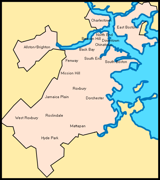
is sometimes called a "city of neighborhoods." There are 21 designated neighborhood areas in Boston used by the city. Bostonians also have a variety of overlapping districts which they consider neighborhoods, squares, areas, etc. Many other boundaries established by the city's residential parking districts, the U.S. Postal Service, and a multitude of individual neighborhoods and neighborhood associations exist throughout the city.
"Neighborhoods" exist on both large and small scales. Brighton (including Allston), Charlestown, Dorchester (including South Boston, Mattapan, and Hyde Park), Roxbury (including West Roxbury, Roslindale and Jamaica Plain), have all at some point been municipalities independent from downtown Boston, providing a source of well-defined boundaries for the largest areas. Neighborhood associations often form around much smaller communities, or around a commercial district (often with "Square" in the name) with a well-defined center but poorly identified extremities.
Boston's leveling and expansion by landfill has influenced the naming of certain neighborhoods, such as the Back Bay, South Cove, and Fort Point. The West End, North End, and South End are no longer at those geographic extremities, due to the annexation of surrounding communities. The names originally referred to their positions on the Shawmut Peninsula
Shawmut Peninsula
Shawmut Peninsula is the promontory of land on which Boston, Massachusetts was built. The peninsula, originally a mere in area, more than doubled in size due to land reclamation efforts, a feature of the history of Boston throughout the 19th century....
, the original extent of Boston.
Overview
Chinatown, Boston
The only historically Chinese area in New England, Chinatown, Boston is a neighborhood located in downtown Boston, Massachusetts. Centered on Beach Street, the neighborhood borders Boston Common, Downtown Crossing, the South End, and the Southeast Expressway/Massachusetts Turnpike.Part of it...
, and Leather District.
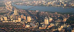
Surrounding downtown are the neighborhoods of the South End, North End, West End, Bay Village, Beacon Hill, and Back Bay. The South End
South End, Boston, Massachusetts
The South End is a neighborhood of Boston, Massachusetts.-Geography:The South End lies south of the Back Bay, northwest of South Boston, northeast of Roxbury, north of Dorchester, and southwest of Bay Village...
is the center of the city's LGBT
LGBT
LGBT is an initialism that collectively refers to "lesbian, gay, bisexual, and transgender" people. In use since the 1990s, the term "LGBT" is an adaptation of the initialism "LGB", which itself started replacing the phrase "gay community" beginning in the mid-to-late 1980s, which many within the...
population and also populated by artists and young professionals as well as a vibrant African American community. The North End retains an Italian flavor with its many Italian restaurants, though many of its Italian families have moved out, while young professionals have moved in. The Back Bay, west of the Public Garden
Boston Public Garden
The Public Garden, also known as Boston Public Garden, is a large park located in the heart of Boston, Massachusetts, adjacent to Boston Common.-History:...
, is one of the wealthiest neighborhoods in the United States
United States
The United States of America is a federal constitutional republic comprising fifty states and a federal district...
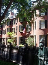
. Beacon Hill
Beacon Hill, Boston, Massachusetts
Beacon Hill is a historic neighborhood of Boston, Massachusetts, that along with the neighboring Back Bay is home to about 26,000 people. It is a neighborhood of Federal-style rowhouses and is known for its narrow, gas-lit streets and brick sidewalks...
, another wealthy neighborhood, is the site of the Massachusetts State House
Massachusetts State House
The Massachusetts State House, also known as the Massachusetts Statehouse or the "New" State House, is the state capitol and house of government of the Commonwealth of Massachusetts. It is located in Boston in the neighborhood Beacon Hill...
. The Back Bay and Beacon Hill are also home to national and local politicians, famous authors, and top business leaders and professionals. Bay Village
Bay Village, Boston, Massachusetts
Bay Village is the second smallest and arguably least-known officially-recognized neighborhood of Boston, Massachusetts. As of 2010, its population was approximately 1,312 residents living in 837 housing units, most of which are small brick rowhouses....
is smallest and arguably least known neighborhood in Boston, most of its residents live in small brick row houses.
North and east of downtown are the neighborhoods of East Boston and Charlestown. East Boston
East Boston, Massachusetts
East Boston is a neighborhood of Boston, Massachusetts, with approximately 40,000 residents. The community was created by connecting several islands using landfill and was annexed by Boston in 1836. East Boston is separated from the rest of the city by Boston Harbor and bordered by Winthrop,...
has a majority a Hispanic and Brazilian population with a remnant of older Italians. On the north bank of the Charles River
Charles River
The Charles River is an long river that flows in an overall northeasterly direction in eastern Massachusetts, USA. From its source in Hopkinton, the river travels through 22 cities and towns until reaching the Atlantic Ocean at Boston...
is Charlestown
Charlestown, Massachusetts
Charlestown is a neighborhood of Boston, Massachusetts, United States, and is located on a peninsula north of downtown Boston. Charlestown was originally a separate town and the first capital of the Massachusetts Bay Colony; it became a city in 1847 and was annexed by Boston on January 5, 1874...
, once a predominantly Irish enclave and site of the Bunker Hill Monument, now is a haven for young professionals.
West of downtown are the neighborhoods of Fenway-Kenmore, Allston-Brighton and Mission Hill. Fenway/Kenmore
Fenway-Kenmore
Fenway–Kenmore is an official neighborhood of Boston, Massachusetts. While it is considered one neighborhood for administrative purposes, it is composed of numerous distinct sections and in casual conversation are almost always referred to as "Fenway," "Kenmore Square," or "Kenmore."...
borders the campus of Boston University
Boston University
Boston University is a private research university located in Boston, Massachusetts. With more than 4,000 faculty members and more than 31,000 students, Boston University is one of the largest private universities in the United States and one of Boston's largest employers...
and houses many college students and young professionals and is the location of Fenway Park
Fenway Park
Fenway Park is a baseball park near Kenmore Square in Boston, Massachusetts. Located at 4 Yawkey Way, it has served as the home ballpark of the Boston Red Sox baseball club since it opened in 1912, and is the oldest Major League Baseball stadium currently in use. It is one of two "classic"...
. Allston/Brighton is populated heavily by students from nearby universities, as well as recent graduates. Mission Hill
Mission Hill, Boston, Massachusetts
Mission Hill is a 3/4 square mile neighborhood of Boston, with the population of approximately 18,000 people.The neighborhood is roughly bounded by Columbus Avenue and the Boston neighborhood of Roxbury to the east, Longwood Avenue to the northeast and the Olmsted designed Riverway/Jamaicaway and...
is adjacent to the Longwood Medical district, full of world-class medical institutions and retains an extremely diverse mix of African Americans, Asian Americans, whites and Latinos.
South of downtown are the neighborhoods of Roxbury, Jamaica Plain, Dorchester, and South Boston. Dorchester
Dorchester, Massachusetts
Dorchester is a dissolved municipality and current neighborhood of Boston, Massachusetts, United States. It is named after the town of Dorchester in the English county of Dorset, from which Puritans emigrated and is today endearingly nicknamed "Dot" by its residents. Dorchester, including a large...
is Boston's largest neighborhood and predominantly a working class community considered to be Boston's most diverse. Roxbury
Roxbury, Massachusetts
Roxbury is a dissolved municipality and current neighborhood of Boston, Massachusetts, United States. It was one of the first towns founded in the Massachusetts Bay Colony in 1630, and became a city in 1846 until annexed to Boston on January 5, 1868...
is populated largely by African Americans, Caribbean Americans, and Latinos and is historically the center of Boston's black community. Jamaica Plain
Jamaica Plain, Massachusetts
Jamaica Plain is a historic neighborhood of in Boston, Massachusetts. Founded by Boston Puritans seeking farm land to the south, it was originally part of the city of Roxbury...
is a community of white professionals and Latinos, and includes the larger side of the Arnold Arboretum. South Boston
South Boston, Massachusetts
South Boston is a densely populated neighborhood of Boston, Massachusetts, located south and east of the Fort Point Channel and abutting Dorchester Bay. One of America's oldest and most historic neighborhoods, South Boston was formerly known as Dorchester Neck, and today is called "Southie" by...
is a predominantly Irish-American neighborhood, which hosts the city's annual St. Patrick's Day parade.
South of Roxbury, Jamaica Plain, and Dorchester are the neighborhoods of Mattapan, Roslindale, Hyde Park, and West Roxbury. Roslindale is known for its small business district and includes the smaller side of the Arnold Arboretum, Roslindale has also recently become a Majority minority neighborhood. Mattapan
Mattapan, Massachusetts
Mattapan is a neighborhood in Boston, Massachusetts. Historically a section of neighboring Dorchester, Mattapan became a part of Boston when Dorchester was annexed in 1870. As of the 2010 census, it had a population of 36,480...
remains the neighborhood with Boston's highest concentrations of African Americans. Hyde Park
Hyde Park, Massachusetts
Hyde Park is a dissolved municipality and currently the southernmost neighborhood of Boston, Massachusetts, United States. Hyde Park is home to a diverse range of people, housing types and social groups. It is an urban location with suburban characteristics...
and West Roxbury
West Roxbury, Massachusetts
West Roxbury is a neighborhood in Boston bordered by Roslindale to the north, the Town of Dedham to the east and south, the Town of Brookline and the City of Newton to the west. Many people mistakenly confuse West Roxbury with Roxbury, but the two are not connected. West Roxbury is separated from...
have a distinct suburban feel, while still being a part of the city of Boston. Both neighborhoods have large areas of wooded parks and recreation land. Hyde Park is populated largely by African Americans and Caribbean Americans. Whereas West Roxbury is predominately white with rapidly growing growing African American and Latino populations.
Neighborhood areas
The City of Boston is officially divided into 21 neighborhoods for purposes of neighborhood services programs. These are:- Allston/Brighton
- Back Bay
- Bay VillageBay Village, Boston, MassachusettsBay Village is the second smallest and arguably least-known officially-recognized neighborhood of Boston, Massachusetts. As of 2010, its population was approximately 1,312 residents living in 837 housing units, most of which are small brick rowhouses....
- Beacon Hill
- CharlestownCharlestown, MassachusettsCharlestown is a neighborhood of Boston, Massachusetts, United States, and is located on a peninsula north of downtown Boston. Charlestown was originally a separate town and the first capital of the Massachusetts Bay Colony; it became a city in 1847 and was annexed by Boston on January 5, 1874...
- ChinatownChinatown, BostonThe only historically Chinese area in New England, Chinatown, Boston is a neighborhood located in downtown Boston, Massachusetts. Centered on Beach Street, the neighborhood borders Boston Common, Downtown Crossing, the South End, and the Southeast Expressway/Massachusetts Turnpike.Part of it...
/Leather District - Dorchester
- DowntownDowntown CrossingDowntown Crossing is a shopping district in Boston, Massachusetts, located due east of Boston Common and west of the Financial District. It features large department stores as well as restaurants, music stores, souvenir sellers, general retail establishments, and many street vendors...
/Financial District - East Boston
- Fenway/KenmoreFenway-KenmoreFenway–Kenmore is an official neighborhood of Boston, Massachusetts. While it is considered one neighborhood for administrative purposes, it is composed of numerous distinct sections and in casual conversation are almost always referred to as "Fenway," "Kenmore Square," or "Kenmore."...
- Hyde Park
- Jamaica Plain
- Mattapan
- Mission Hill
- North End
- Roslindale
- Roxbury
- South Boston
- South End
- West End
- West Roxbury
Some insular territories are administered as part of the Boston Harbor Islands National Recreation Area
Boston Harbor Islands National Recreation Area
The Boston Harbor Islands National Recreation Area is a National Recreation Area situated among the islands of Boston Harbor of Boston, Massachusetts. The area is made up of a collection of islands, together with a former island and a peninsula, many of which are open for public recreation and some...
.
List of places and squares within neighborhood areas
The 21 official neighborhoods in Boston are made up of approximately 84 sub-districts, squares, and neighborhoods within each official neighborhood.The Boston Redevelopment Authority defines 16 planning districts (plus the Boston Harbor Islands) and 64 Neighborhood Statistical Areas (with four areas further subdivided). These correspond roughly with the neighborhoods and sub-neighborhoods of Boston. Unofficially, Boston is made up of approximately 105 neighborhoods.- Allston/Brighton
- Allston Village
- Brighton Center
- Chestnut HillChestnut Hill, MassachusettsChestnut Hill is a wealthy New England village located six miles west of downtown Boston, Massachusetts, United States. Like all Massachusetts villages, Chestnut Hill is not an incorporated municipal entity, but unlike most of them, it encompasses parts of three separate municipalities, each of...
- Cleveland CircleCleveland CircleCleveland Circle, an area of Boston, Massachusetts, is located in Boston's Brighton neighborhood, and more specifically the Aberdeen section of Brighton, in very close proximity to Brookline and Chestnut Hill, Massachusetts, at the intersection of Beacon Street and Chestnut Hill Avenue.Cleveland...
- Harvard StadiumHarvard StadiumHarvard Stadium is a horseshoe-shaped football stadium in the Allston neighborhood of Boston, Massachusetts, in the United States. Built in 1903, the stadium seats 30,323. The stadium seated up to 57,166 in the past, as permanent steel stands were installed in the north end of the stadium in 1929...
/Charlesview - Union SquareUnion Square, BostonUnion Square is located in the Allston neighborhood of Boston, Massachusetts at the intersection of Cambridge Street and Brighton Avenue/North Beacon Street. Union Square is serviced by the MBTA 66 and 57 buses. The 66 bus goes east on Brighton Avenue towards Brookline and north on Cambridge...
- Oak Square
- Faneuil Square
- Brighton Mills
- Lower Allston
- North Brighton
- Packard's CornerPackard's CornerPackard's Corner is located in Boston, Massachusetts at the intersection of Commonwealth Avenue and Brighton Avenue. Packard's Corner is serviced by the Packard's Corner stop on the B Branch of the MBTA's Green Line, a light rail line that runs mostly above ground...
- Soldier's Field
- Back Bay
- Copley SquareCopley SquareCopley Square is a public square located in the Back Bay neighborhood of Boston, Massachusetts, named for the donor of the land on which it was developed. The square is named for John Singleton Copley, a famous portrait painter of the late 18th century and native of Boston. A bronze statue of...
/Boston Public LibraryBoston Public LibraryThe Boston Public Library is a municipal public library system in Boston, Massachusetts, United States. It was the first publicly supported municipal library in the United States, the first large library open to the public in the United States, and the first public library to allow people to... - Commonwealth Avenue MallCommonwealth Avenue, BostonCommonwealth Avenue is a major street in the cities of Boston and Newton, Massachusetts. It begins at the western edge of the Public Garden, and continues west through the neighborhoods of the Back Bay, Kenmore Square, Allston, Brighton and Chestnut Hill...
- Newbury Street
- Copley Square
- Bay VillageBay Village, Boston, MassachusettsBay Village is the second smallest and arguably least-known officially-recognized neighborhood of Boston, Massachusetts. As of 2010, its population was approximately 1,312 residents living in 837 housing units, most of which are small brick rowhouses....
(also known as South Cove) - Beacon HillBeacon Hill, Boston, MassachusettsBeacon Hill is a historic neighborhood of Boston, Massachusetts, that along with the neighboring Back Bay is home to about 26,000 people. It is a neighborhood of Federal-style rowhouses and is known for its narrow, gas-lit streets and brick sidewalks...
- Louisburg SquareLouisburg SquareLouisburg Square is a private square located in the Beacon Hill, Boston, Massachusetts neighborhood of Boston. It was named for the 1745 Battle of Louisbourg, in which Massachusetts militiamen led by William Pepperrell, who was made the first American baronet for his role, sacked the French...
- Massachusetts State HouseMassachusetts State HouseThe Massachusetts State House, also known as the Massachusetts Statehouse or the "New" State House, is the state capitol and house of government of the Commonwealth of Massachusetts. It is located in Boston in the neighborhood Beacon Hill...
- Louisburg Square
- CharlestownCharlestown, MassachusettsCharlestown is a neighborhood of Boston, Massachusetts, United States, and is located on a peninsula north of downtown Boston. Charlestown was originally a separate town and the first capital of the Massachusetts Bay Colony; it became a city in 1847 and was annexed by Boston on January 5, 1874...
- Bunker HillBattle of Bunker HillThe Battle of Bunker Hill took place on June 17, 1775, mostly on and around Breed's Hill, during the Siege of Boston early in the American Revolutionary War...
- The Neck
- The Navy Yard
- Hayes Square
- City Square
- Thompson Square
- Sullivan Square
- Bunker Hill
- ChinatownChinatown, BostonThe only historically Chinese area in New England, Chinatown, Boston is a neighborhood located in downtown Boston, Massachusetts. Centered on Beach Street, the neighborhood borders Boston Common, Downtown Crossing, the South End, and the Southeast Expressway/Massachusetts Turnpike.Part of it...
and the Leather DistrictLeather District, Boston, MassachusettsThe Leather District is a neighborhood of Boston near South Street, between the Financial District and Chinatown. The Leather District is a tightly defined area bounded by Kneeland Street to the south, Essex Street to the north, Atlantic Avenue to the east and Lincoln Street to the west...
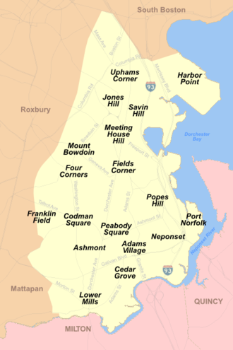
- DorchesterDorchester, MassachusettsDorchester is a dissolved municipality and current neighborhood of Boston, Massachusetts, United States. It is named after the town of Dorchester in the English county of Dorset, from which Puritans emigrated and is today endearingly nicknamed "Dot" by its residents. Dorchester, including a large...
- Adams Corner/Adams Village
- AshmontAshmont, MassachusettsAshmont is a section of the Dorchester neighborhood of Boston. It includes the subsections of Ashmont Hill, Peabody Square, and Ashmont-Adams. Located near the Milton/Boston border, major streets include Ashmont Street, Gallivan Blvd., and Dorchester Avenue....
(including Ashmont Hill, Ashmont-Adams, and Peabody Square) - Codman Square/Dorchester Center
- Columbia PointColumbia Point (Boston)Columbia Point, later referred to as Harbor Point, in the Dorchester neighborhood of Boston, Massachusetts sits on a peninsula jutting out from the mainland of eastern Dorchester into the bay.-History:...
/Harbor Point - Cedar Grove
- Fields Corner
- Four Corners
- Franklin Field
- Grove Hall
- Lower MillsDorchester-Milton Lower Mills Industrial DistrictDorchester-Milton Lower Mills Industrial District is an historic district on both sides of the Neponset River in the Dorchester neighborhood of Boston, Massachusetts and the Town of Milton, Massachusetts...
- Jones Hill
- Meeting House Hill
- Mount Bowdoin
- NeponsetNeponset, MassachusettsNeponset, Massachusetts is a district in the southeast corner of Dorchester, Massachusetts which is the most populous neighborhood of Boston....
- Polish Triangle
- Popes Hill
- Port Norfolk
- Savin HillSavin HillSavin Hill is the first album by punk band Street Dogs. This is the first new material featuring lead singer Mike McColgan since he quit Dropkick Murphys in 1998...
- Uphams CornerUphams CornerUphams Corner is a section of Dorchester, the largest neighborhood of Boston, Massachusetts, USA. The intersection of Dudley Street and Columbia Road is the heart of Uphams Corner, and one of Dorchester's main business districts. Uphams Corner is served by several bus lines and the MBTA's...
- Downtown Boston and the Financial DistrictFinancial District, Boston, MassachusettsThe Financial District of Boston, Massachusetts, United States is located in the downtown area near Government Center and Chinatown.Like many areas within Boston, the Financial District has no official definition. It is roughly bounded by Atlantic Avenue, State Street, and Devonshire Street...
- Bulfinch Triangle
- Combat ZoneCombat Zone (Boston)The "Combat Zone", in Boston, Massachusetts, was the name given to the adult entertainment district in downtown centered on Washington Street between Boylston Street and Kneeland Street. It extended up Stuart Street to Park Square...
(defunct) - Downtown CrossingDowntown CrossingDowntown Crossing is a shopping district in Boston, Massachusetts, located due east of Boston Common and west of the Financial District. It features large department stores as well as restaurants, music stores, souvenir sellers, general retail establishments, and many street vendors...
/Ladder District - Fort Hill Square
- Government Center
- Haymarket Square (Boston)Haymarket Square (Boston)Haymarket Square in Boston is an open-air fruit and vegetable market near the North End, Government Center, West End and Faneuil Hall Marketplace...
- Post Office SquarePost Office SquarePost Office Square may refer to:* Post Office Square, Boston, Massachusetts* Post Office Square, Brisbane - Post Office Square in Brisbane, Queensland, Australia...
- South StationSouth StationSouth Station, New England's second-largest transportation center , located at the intersection of Atlantic Avenue and Summer Street in Dewey Square, Boston, Massachusetts, is the largest train station and intercity bus terminal in Greater Boston, a prominent train station in the northeastern...
- Theatre District
- Waterfront
- East BostonEast Boston, MassachusettsEast Boston is a neighborhood of Boston, Massachusetts, with approximately 40,000 residents. The community was created by connecting several islands using landfill and was annexed by Boston in 1836. East Boston is separated from the rest of the city by Boston Harbor and bordered by Winthrop,...
- Bennington Street
- Central SquareCentral Square, East Boston, MassachusettsCentral Square culminates around the intersection of Bennington Street and Meridian Street in the Boston neighborhood of East Boston. The square’s intersecting streets also includes Border Street, Saratoga Street and Liverpool Street...
- Chelsea Street
- Day SquareDay SquareDay Square is the area surrounding the intersection of Bennington Street and Chelsea Street in the Boston neighborhood of East Boston. It is one of the community's larger business districts, housing a significant number of restaurants, barbershops, and beauty salons including Elvis and Eli's....
- Jeffries PointJeffries PointJeffries Point is a point on the south-central side of Cook Island in the South Sandwich Islands. Charted in 1930 by DI personnel on the assistant to the staff of the Discovery Committee. Jeffries Point is also the name of a neighborhood along the waterfront in East Boston in the Commonwealth of...
- Logan International AirportLogan International AirportGeneral Edward Lawrence Logan International Airport is located in the East Boston neighborhood of Boston, Massachusetts . It covers , has six runways, and employs an estimated 16,000 people. It is the 19th busiest airport in the United States.Boston serves as a focus city for JetBlue Airways...
- Maverick SquareMaverick SquareMaverick Square is a business district in the Boston neighborhood of East Boston that is intersected by several thoroughfares, most notably Chelsea Street and Meridian Street. It is the location of a station on the Blue Line of the MBTA...
- Orient HeightsOrient HeightsOrient Heights is an historic section of East Boston. The neighborhood sits on a hill named "Orient Heights;" the hill measures 152 feet in elevation at its highest point...
- Fenway/KenmoreFenway-KenmoreFenway–Kenmore is an official neighborhood of Boston, Massachusetts. While it is considered one neighborhood for administrative purposes, it is composed of numerous distinct sections and in casual conversation are almost always referred to as "Fenway," "Kenmore Square," or "Kenmore."...
- Audubon Circle
- Back Bay FensBack Bay FensThe Back Bay Fens, most commonly called simply The Fens, is a parkland and urban wild in Boston, Massachusetts, in the United States.Designed by Frederick Law Olmsted to serve as a link in the Emerald Necklace park system, the Fens gives its name to the Fenway-Kenmore neighborhood, and thereby to...
- Kenmore SquareKenmore SquareKenmore Square is a square in Boston, Massachusetts, United States, consisting of the intersection of several main avenues as well as several other cross streets, and Kenmore Station, an MBTA subway stop. Kenmore Square is close to or abuts Boston University, Fenway Park, and Lansdowne Street, a...
- Boston UniversityBoston UniversityBoston University is a private research university located in Boston, Massachusetts. With more than 4,000 faculty members and more than 31,000 students, Boston University is one of the largest private universities in the United States and one of Boston's largest employers...
(extends into Allston) - Longwood Medical Area (extends into Mission Hill)
- Lansdowne Street/Fenway ParkFenway ParkFenway Park is a baseball park near Kenmore Square in Boston, Massachusetts. Located at 4 Yawkey Way, it has served as the home ballpark of the Boston Red Sox baseball club since it opened in 1912, and is the oldest Major League Baseball stadium currently in use. It is one of two "classic"...
- Hyde ParkHyde Park, MassachusettsHyde Park is a dissolved municipality and currently the southernmost neighborhood of Boston, Massachusetts, United States. Hyde Park is home to a diverse range of people, housing types and social groups. It is an urban location with suburban characteristics...
- ReadvilleReadville, MassachusettsReadville, called Low Plains from 1655 until renaming in 1847 after Mr. James Read originally part of Dedham until 1867 but now a part of Boston, is considered either a part of the Hyde Park neighborhood, or a neighborhood in its own right. It is served by Readville station on the MBTA Commuter Rail...
- Fairmount Hill
- Sunnyside
- Readville
- Jamaica PlainJamaica Plain, MassachusettsJamaica Plain is a historic neighborhood of in Boston, Massachusetts. Founded by Boston Puritans seeking farm land to the south, it was originally part of the city of Roxbury...
- Hyde Square
- Forest HillsForest Hills, BostonForest Hills is a part of the Jamaica Plain neighborhood of Boston, Massachusetts, United States.-Overview:As the name indicates, Forest Hills is characterized by hilly terrain and wooded areas within and adjacent to its borders...
/Woodbourne - Moss Hill
- MattapanMattapan, MassachusettsMattapan is a neighborhood in Boston, Massachusetts. Historically a section of neighboring Dorchester, Mattapan became a part of Boston when Dorchester was annexed in 1870. As of the 2010 census, it had a population of 36,480...
- Wellington Hill
- Mission HillMission Hill, Boston, MassachusettsMission Hill is a 3/4 square mile neighborhood of Boston, with the population of approximately 18,000 people.The neighborhood is roughly bounded by Columbus Avenue and the Boston neighborhood of Roxbury to the east, Longwood Avenue to the northeast and the Olmsted designed Riverway/Jamaicaway and...
- Brigham Circle
- Back of the Hill
- Parker Hill
- North End
- Ann Street (North Street)
- Hanover Street
- Roslindale
- Roslindale Square
- RoxburyRoxbury, MassachusettsRoxbury is a dissolved municipality and current neighborhood of Boston, Massachusetts, United States. It was one of the first towns founded in the Massachusetts Bay Colony in 1630, and became a city in 1846 until annexed to Boston on January 5, 1868...
- Dudley SquareDudley SquareDudley Square is the primary commercial center of the Roxbury neighborhood of Boston, Massachusetts, located at the intersection of Dudley Street and Washington Street...
- Egleston Square
- Franklin ParkFranklin Park, BostonFranklin Park, a partially wooded parkland in the Jamaica Plain, Roxbury, and Dorchester neighborhoods of Boston, Massachusetts, is maintained by the City of Boston Parks and Recreation Department...
(extends into Jamaica Plain and Dorchester) - Roxbury Crossing
- Dudley Square
- South BostonSouth Boston, MassachusettsSouth Boston is a densely populated neighborhood of Boston, Massachusetts, located south and east of the Fort Point Channel and abutting Dorchester Bay. One of America's oldest and most historic neighborhoods, South Boston was formerly known as Dorchester Neck, and today is called "Southie" by...
- Andrew Square (extends into Dorchester)
- D Street
- City Point
- Fort PointFort Point, BostonFort Point is a neighborhood or district of Boston, Massachusetts, which is named after the location of a fort which guarded the city in colonial times....
- South Boston Waterfront/Seaport District
- South EndSouth End, Boston, MassachusettsThe South End is a neighborhood of Boston, Massachusetts.-Geography:The South End lies south of the Back Bay, northwest of South Boston, northeast of Roxbury, north of Dorchester, and southwest of Bay Village...
- South of Washington (SoWa)SoWaThe SoWa district in Boston, Massachusetts is a gallery area , centered on the SoWa Building, at 450 Harrison Avenue.-History:GTI Properties is credited with rejuvenating the SoWa district...
- South of Washington (SoWa)
- West EndWest End, Boston, MassachusettsThe West End is a neighborhood of Boston, Massachusetts, bounded generally by Cambridge Street to the south, the Charles River to the west and northwest, North Washington Street on the north and northeast, and New Sudbury Street on the east. Beacon Hill is to the south, and the North End is to the...
- Charles Street
- North Station/TD Garden
- Massachusetts General HospitalMassachusetts General HospitalMassachusetts General Hospital is a teaching hospital and biomedical research facility in the West End neighborhood of Boston, Massachusetts...
- West RoxburyWest Roxbury, MassachusettsWest Roxbury is a neighborhood in Boston bordered by Roslindale to the north, the Town of Dedham to the east and south, the Town of Brookline and the City of Newton to the west. Many people mistakenly confuse West Roxbury with Roxbury, but the two are not connected. West Roxbury is separated from...