
Fenway-Kenmore
Encyclopedia
Fenway–Kenmore is an official neighborhood of Boston
, Massachusetts
. While it is considered one neighborhood for administrative purposes, it is composed of numerous distinct sections (East Fenway, West Fenway, Audubon Circle, Kenmore Square) and in casual conversation are almost always referred to as "Fenway," "Kenmore Square," or "Kenmore." Furthermore, the Fenway neighborhood is divided into two sub-neighborhoods commonly referred to as East Fenway/Symphony and West Fenway.
Fenway is named after the Fenway, a main thoroughfare laid out by Frederick Law Olmsted
. As of the 2010 Boston Redevelopment Authority Census, Fenway–Kenmore's population was 40,898, while its land area was defined to be 1.24 square miles (3.2 km²).
, the Back Bay Fens
is in the center of the neighborhood, Columbus Avenue forms the south eastern border, Massachusetts Avenue forms the eastern border, the northern border is roughly the Mass Pike, and on the west by the Longwood Medical Area (part of Roxbury) and the neighboring town of Brookline. The neighborhood consists almost entirely of five- to six-story apartment buildings typically constructed between 1880 and 1930, with rare small, independently-owned shops scattered throughout. Fenway is separated from the Back Bay neighborhood by the Muddy River, which flows through the Back Bay Fens and into the Charles River
.
Kenmore is located north and west of Fenway, and shares many of the same attributes of Fenway. Fenway Park is in fact located in Kenmore, right across the Mass Pike
from Kenmore Square
. Many students from nearby Boston University and Northeastern University reside in the neighborhood. The area is almost entirely brick, walk-up buildings and brownstone townhouses, although over the last 20 years almost every residential building in Kenmore has been purchased by Boston University
and turned into dorms, especially in the Audubon Circle area between Beacon Street and Commonwealth Avenue.
When planned, it was thought that the buildings built upon the Fenway parkway would house high-wealth residents and that the whole area would be a high-class neighborhood. As property values rose, however, it was educational institutions that sprung up along the Fenway's route. By 1907, there were twenty-two educationally focused organizations, including nine college and universities which had made their homes on the Fenway. Residential buildings that were built needed their frontages to be approved by the Park Board so that a "poor looking building [did not] depreciate the value of the whole neighborhood". Additionally, the Board had discretion on whether it felt a proposed building was suitable for frontage along the park and parkway. The hope of these building restrictions was that there would be an improvement in the look of the Fenway compared to neighboring streets.
In the last few years, development in Fenway has picked up, particularly from developer Samuels and Associates. Recent developments include the renovation of the Landmark Center; the 2003 addition of Hotel Commonwealth on the site of the Rathskeller
bar; and the 576-unit, 17-floor Trilogy apartment building on Brookline Avenue and Boylston Street. 1330 Boylston, a second high-rise apartment building, was completed in 2008 and contains 210 apartments, 85000 square feet (7,896.8 m²) of office space contained within 10 floors and the new home of Fenway Health
.
Planned developments include a 24-story mixed use development at the confluence of Bolyston Street and Brookline Avenue, likely including retail, dining, and luxury hotel/apartments. Other plans include the renovation of the Howard Johnson motel on Bolyston Street, to be rehabbed as an upscale hotel. Additionally, developer John Rosenthal is planning to build a complex named One Kenmore over the Mass Pike alongside the Beacon Street Bridge, comprising 525 units in one 17 floor tower and one 20 floor tower. Concerning infrastructure, in 2007 the MBTA renovated the Fenway Green Line stop
, and is planning to renovate the nearby Yawkey Way Commuter Rail Station. Finally, the Museum of Fine Arts is in the midst of a $425 million expansion, and the Isabella Stewart Gardener Museum
is undergoing construction of a second building.
The parkways Fenway and Park Drive
surrounding the Back Bay Fens
are named after various parks which are part of the Emerald Necklace
park system. Other streets in Fenway are named after institutions or civic minded patrons within the neighborhood: Palace Road, Forsyth Way, Evans Way, Forsyth Street, Hemenway Street, Agassiz Road (named after Ida Agassiz), Yawkey Way, Symphony Road, St. Stephens Street (St. Stephen's Church became St. Ann's, which is now known as Northeastern University's Fenway Center), Opera Place (The Boston Opera House
was demolished in 1958), and Speare Place.
of 2000 and the City of Boston, there were 36,191 people, 12,872 households, and 5,428 families residing in the neighborhood. The population density
was 29,186.3 people per square mile (11,268.9/km²). Of the neighborhood's housing structures, 1% were single family dwellings while 15% had 3-9 units, 16% had 10-19 units, 41% had 20-49 units, and 27% had 50 or more units; there were 13,229 units in total. 91% percent of units were occupied by renters while 9% were owner occupied. The average household size was 1.69 people, while the average family size was 2.61 and non-family 1.51.
The racial makeup of the neighborhood was 71% White, 7% Black or African American, 14% Asian, 4% from other races
, and 3% from two or more races. Hispanic or Latino of any race were 8% of the population. 21.3% of the population was foreign born.
The neighborhood population consisted of 4% under the age of 18, 63% from 18 to 24, 23% from 25 to 44, 6% from 45 to 64, and 5% who were 65 years of age or older. The median income for a household in the neighborhood was $25,356. 37.3% of the population was below the poverty line, while the unemployment rate was 11.4%.
East Fenway has a large student population due to its proximity to area colleges and universities, while West Fenway, formerly known as a student haven, has seen rising interest from young professionals and families. The Kenmore Square area is mainly commercial with many residential units now owned by Boston University and used as on-campus housing for students.
, the famous Citgo sign, Kenmore Square
, The Art Institute of Boston
, The Forsyth Institute
, Massachusetts College of Pharmacy and Health Sciences
, Northeastern University, the New England Conservatory, portions of Boston University
(including the Myles Standish Residence Hall), portions of the Harvard Medical School
, Berklee College of Music
, The Boston Conservatory
, Massachusetts College of Art
, Wentworth Institute of Technology
, Simmons College
, Wheelock College
, Emmanuel College, New England School of Photography
, Holy Trinity Orthodox Cathedral, the Isabella Stewart Gardner Museum
and the Museum of Fine Arts, Boston
.
 The neighborhood is ringed by the MBTA Orange Line Ruggles
subway station and the following MBTA Green Line trolley stops:
Yawkey Station
on the Framingham/Worcester Line
of the MBTA Commuter Rail
is located near Fenway Park and Kenmore Square and provides limited inbound and outbound stops for commuters during rush hour. Fenway–Kenmore is also served by a number of MBTA bus
es connecting it to the city proper and the surrounding neighborhoods and communities.
As for roadways, Fenway and Park Drive
circulate around The Fens. Boylston Street
is a major east-west route, as are Beacon Street
and Commonwealth Avenue
, which intersect at Kenmore Square
. Brookline Avenue
begins in Kenmore Square at this intersection and proceeds southwest. Huntington Avenue (MA Route 9) is on the southern border, while Massachusetts Avenue
forms the eastern border, and is a major north-south route. Although the Massachusetts Turnpike
cuts through the neighborhood, there are no access points to it except westbound only at Massachusetts Avenue and Newbury Street.
Boston
Boston is the capital of and largest city in Massachusetts, and is one of the oldest cities in the United States. The largest city in New England, Boston is regarded as the unofficial "Capital of New England" for its economic and cultural impact on the entire New England region. The city proper had...
, Massachusetts
Massachusetts
The Commonwealth of Massachusetts is a state in the New England region of the northeastern United States of America. It is bordered by Rhode Island and Connecticut to the south, New York to the west, and Vermont and New Hampshire to the north; at its east lies the Atlantic Ocean. As of the 2010...
. While it is considered one neighborhood for administrative purposes, it is composed of numerous distinct sections (East Fenway, West Fenway, Audubon Circle, Kenmore Square) and in casual conversation are almost always referred to as "Fenway," "Kenmore Square," or "Kenmore." Furthermore, the Fenway neighborhood is divided into two sub-neighborhoods commonly referred to as East Fenway/Symphony and West Fenway.
Fenway is named after the Fenway, a main thoroughfare laid out by Frederick Law Olmsted
Frederick Law Olmsted
Frederick Law Olmsted was an American journalist, social critic, public administrator, and landscape designer. He is popularly considered to be the father of American landscape architecture, although many scholars have bestowed that title upon Andrew Jackson Downing...
. As of the 2010 Boston Redevelopment Authority Census, Fenway–Kenmore's population was 40,898, while its land area was defined to be 1.24 square miles (3.2 km²).
Location
Fenway is a neighborhood bounded on the south west by Mission HillMission Hill, Boston, Massachusetts
Mission Hill is a 3/4 square mile neighborhood of Boston, with the population of approximately 18,000 people.The neighborhood is roughly bounded by Columbus Avenue and the Boston neighborhood of Roxbury to the east, Longwood Avenue to the northeast and the Olmsted designed Riverway/Jamaicaway and...
, the Back Bay Fens
Back Bay Fens
The Back Bay Fens, most commonly called simply The Fens, is a parkland and urban wild in Boston, Massachusetts, in the United States.Designed by Frederick Law Olmsted to serve as a link in the Emerald Necklace park system, the Fens gives its name to the Fenway-Kenmore neighborhood, and thereby to...
is in the center of the neighborhood, Columbus Avenue forms the south eastern border, Massachusetts Avenue forms the eastern border, the northern border is roughly the Mass Pike, and on the west by the Longwood Medical Area (part of Roxbury) and the neighboring town of Brookline. The neighborhood consists almost entirely of five- to six-story apartment buildings typically constructed between 1880 and 1930, with rare small, independently-owned shops scattered throughout. Fenway is separated from the Back Bay neighborhood by the Muddy River, which flows through the Back Bay Fens and into the Charles River
Charles River
The Charles River is an long river that flows in an overall northeasterly direction in eastern Massachusetts, USA. From its source in Hopkinton, the river travels through 22 cities and towns until reaching the Atlantic Ocean at Boston...
.
Kenmore is located north and west of Fenway, and shares many of the same attributes of Fenway. Fenway Park is in fact located in Kenmore, right across the Mass Pike
Massachusetts Turnpike
The Massachusetts Turnpike is the easternmost stretch of Interstate 90. The Turnpike begins at the western border of Massachusetts in West Stockbridge connecting with the Berkshire Connector portion of the New York State Thruway...
from Kenmore Square
Kenmore Square
Kenmore Square is a square in Boston, Massachusetts, United States, consisting of the intersection of several main avenues as well as several other cross streets, and Kenmore Station, an MBTA subway stop. Kenmore Square is close to or abuts Boston University, Fenway Park, and Lansdowne Street, a...
. Many students from nearby Boston University and Northeastern University reside in the neighborhood. The area is almost entirely brick, walk-up buildings and brownstone townhouses, although over the last 20 years almost every residential building in Kenmore has been purchased by Boston University
Boston University
Boston University is a private research university located in Boston, Massachusetts. With more than 4,000 faculty members and more than 31,000 students, Boston University is one of the largest private universities in the United States and one of Boston's largest employers...
and turned into dorms, especially in the Audubon Circle area between Beacon Street and Commonwealth Avenue.
History
The Fenway–Kenmore area was formed by land annexed from neighboring Brookline in the 1870s as part of the Brookline-Boston annexation debate of 1873 as well as from land filled in in conjunction with the creation of landscape architect Frederick Law Olmsted parks in the 1890s.When planned, it was thought that the buildings built upon the Fenway parkway would house high-wealth residents and that the whole area would be a high-class neighborhood. As property values rose, however, it was educational institutions that sprung up along the Fenway's route. By 1907, there were twenty-two educationally focused organizations, including nine college and universities which had made their homes on the Fenway. Residential buildings that were built needed their frontages to be approved by the Park Board so that a "poor looking building [did not] depreciate the value of the whole neighborhood". Additionally, the Board had discretion on whether it felt a proposed building was suitable for frontage along the park and parkway. The hope of these building restrictions was that there would be an improvement in the look of the Fenway compared to neighboring streets.
In the last few years, development in Fenway has picked up, particularly from developer Samuels and Associates. Recent developments include the renovation of the Landmark Center; the 2003 addition of Hotel Commonwealth on the site of the Rathskeller
The Rathskeller
The Rathskeller was a Kenmore Square live music venue in Boston, Massachusetts that was open from 1974 to 1997. As implied by its name "Ratskeller" , the Rathskeller was a dimly-lit establishment...
bar; and the 576-unit, 17-floor Trilogy apartment building on Brookline Avenue and Boylston Street. 1330 Boylston, a second high-rise apartment building, was completed in 2008 and contains 210 apartments, 85000 square feet (7,896.8 m²) of office space contained within 10 floors and the new home of Fenway Health
Fenway Health
Fenway Health, originally called Fenway Community Health Center, is an LGBT health care, research and advocacy organization. It has had a number of homes over the years, including its current Ansin Building home at 1340 Boylston Street in Boston, which opened its doors in 2009...
.
Planned developments include a 24-story mixed use development at the confluence of Bolyston Street and Brookline Avenue, likely including retail, dining, and luxury hotel/apartments. Other plans include the renovation of the Howard Johnson motel on Bolyston Street, to be rehabbed as an upscale hotel. Additionally, developer John Rosenthal is planning to build a complex named One Kenmore over the Mass Pike alongside the Beacon Street Bridge, comprising 525 units in one 17 floor tower and one 20 floor tower. Concerning infrastructure, in 2007 the MBTA renovated the Fenway Green Line stop
Fenway (MBTA station)
Fenway is a stop on the D branch of the MBTA Green Line. It is located in the Fenway-Kenmore neighborhood of Boston Massachusetts, under Park Drive near The Riverway. Named after the Fenway parkway rather than Fenway Park, it is not the nearest station to the stadium - Yawkey commuter rail and...
, and is planning to renovate the nearby Yawkey Way Commuter Rail Station. Finally, the Museum of Fine Arts is in the midst of a $425 million expansion, and the Isabella Stewart Gardener Museum
Isabella Stewart Gardner Museum
The Isabella Stewart Gardner Museum or Fenway Court, as the museum was known during Isabella Stewart Gardner's lifetime, is a museum in the Fenway-Kenmore neighborhood of Boston, Massachusetts, located within walking distance of the Museum of Fine Arts and near the Back Bay Fens...
is undergoing construction of a second building.
Street names
West Fenway features streets named after Scottish cities and towns present in Robert Burn's literary works; Peterborough, Kilmarnock, Queensbury. This was a result of influence by the Robert Burns (literary) Society influencing the city of Boston when a decision was made to simplify the original neighborhood plan by Frederick Law Olmsted's office. As originally planned in 1894, the street naming system was to continue the system originating in the Back Bay of naming streets in alphabetical order. Where the Back Bay proper ends at Hereford Street, the Fenway was to continue Ipswich, Jersey, Kenyon (Kilmarnock), Lansdowne, Mornington, Nottingham, Onslow, Peterborough, Queensbury, Roseberry, Salisbury, Thurlow, Uxbridge, Vivian, Westmeath (Wellesley), X omitted, York, and Zetland.
The parkways Fenway and Park Drive
Park Drive (parkway)
Park Drive is a mostly one-way, one- to two-lane parkway in the Fenway-Kenmore neighborhood of Boston that runs along the northern and western edges of the Back Bay Fens before ending at Mountfort Street...
surrounding the Back Bay Fens
Back Bay Fens
The Back Bay Fens, most commonly called simply The Fens, is a parkland and urban wild in Boston, Massachusetts, in the United States.Designed by Frederick Law Olmsted to serve as a link in the Emerald Necklace park system, the Fens gives its name to the Fenway-Kenmore neighborhood, and thereby to...
are named after various parks which are part of the Emerald Necklace
Emerald Necklace
The Emerald Necklace consists of an chain of parks linked by parkways and waterways in Boston and Brookline, Massachusetts. It gets its name from the way the planned chain appears to hang from the "neck" of the Boston peninsula, although it was never fully constructed.-Overview:The Necklace...
park system. Other streets in Fenway are named after institutions or civic minded patrons within the neighborhood: Palace Road, Forsyth Way, Evans Way, Forsyth Street, Hemenway Street, Agassiz Road (named after Ida Agassiz), Yawkey Way, Symphony Road, St. Stephens Street (St. Stephen's Church became St. Ann's, which is now known as Northeastern University's Fenway Center), Opera Place (The Boston Opera House
Boston Opera House (1909)
The Boston Opera House was an opera house located on Huntington Avenue in Boston, Massachusetts. It opened in 1909 as the home of the Boston Opera Company and was demolished in 1958 after years of disuse....
was demolished in 1958), and Speare Place.
Demographics
According to the censusCensus
A census is the procedure of systematically acquiring and recording information about the members of a given population. It is a regularly occurring and official count of a particular population. The term is used mostly in connection with national population and housing censuses; other common...
of 2000 and the City of Boston, there were 36,191 people, 12,872 households, and 5,428 families residing in the neighborhood. The population density
Population density
Population density is a measurement of population per unit area or unit volume. It is frequently applied to living organisms, and particularly to humans...
was 29,186.3 people per square mile (11,268.9/km²). Of the neighborhood's housing structures, 1% were single family dwellings while 15% had 3-9 units, 16% had 10-19 units, 41% had 20-49 units, and 27% had 50 or more units; there were 13,229 units in total. 91% percent of units were occupied by renters while 9% were owner occupied. The average household size was 1.69 people, while the average family size was 2.61 and non-family 1.51.
The racial makeup of the neighborhood was 71% White, 7% Black or African American, 14% Asian, 4% from other races
Race (United States Census)
Race and ethnicity in the United States Census, as defined by the Federal Office of Management and Budget and the United States Census Bureau, are self-identification data items in which residents choose the race or races with which they most closely identify, and indicate whether or not they are...
, and 3% from two or more races. Hispanic or Latino of any race were 8% of the population. 21.3% of the population was foreign born.
The neighborhood population consisted of 4% under the age of 18, 63% from 18 to 24, 23% from 25 to 44, 6% from 45 to 64, and 5% who were 65 years of age or older. The median income for a household in the neighborhood was $25,356. 37.3% of the population was below the poverty line, while the unemployment rate was 11.4%.
East Fenway has a large student population due to its proximity to area colleges and universities, while West Fenway, formerly known as a student haven, has seen rising interest from young professionals and families. The Kenmore Square area is mainly commercial with many residential units now owned by Boston University and used as on-campus housing for students.
Establishments
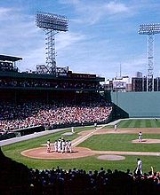
It is the home of Fenway ParkFenway Park
Fenway Park is a baseball park near Kenmore Square in Boston, Massachusetts. Located at 4 Yawkey Way, it has served as the home ballpark of the Boston Red Sox baseball club since it opened in 1912, and is the oldest Major League Baseball stadium currently in use. It is one of two "classic"...
, the famous Citgo sign, Kenmore Square
Kenmore Square
Kenmore Square is a square in Boston, Massachusetts, United States, consisting of the intersection of several main avenues as well as several other cross streets, and Kenmore Station, an MBTA subway stop. Kenmore Square is close to or abuts Boston University, Fenway Park, and Lansdowne Street, a...
, The Art Institute of Boston
The Art Institute of Boston
The Art Institute of Boston is a private, not-for-profit art school in Boston, Massachusetts, and a part of Lesley University. Undergraduate degree programs include animation, design, fine arts, illustration, and photography. Graduate degree programs focus on fine arts and photography, with an art...
, The Forsyth Institute
The Forsyth Institute
Forsyth Institute is one of the leading centers for dental and craniofacial research in the world. It is located in the Fenway area of Boston close to the Museum of Fine Arts and adjacent to Northeastern University. It was once an infirmary for Pediatric Dental Care in Boston...
, Massachusetts College of Pharmacy and Health Sciences
Massachusetts College of Pharmacy and Health Sciences
The Massachusetts College of Pharmacy and Health Sciences is an accredited, private institution located in the Longwood Medical and Academic Area of Boston, Massachusetts...
, Northeastern University, the New England Conservatory, portions of Boston University
Boston University
Boston University is a private research university located in Boston, Massachusetts. With more than 4,000 faculty members and more than 31,000 students, Boston University is one of the largest private universities in the United States and one of Boston's largest employers...
(including the Myles Standish Residence Hall), portions of the Harvard Medical School
Harvard Medical School
Harvard Medical School is the graduate medical school of Harvard University. It is located in the Longwood Medical Area of the Mission Hill neighborhood of Boston, Massachusetts....
, Berklee College of Music
Berklee College of Music
Berklee College of Music, located in Boston, Massachusetts, is the largest independent college of contemporary music in the world. Known primarily as a school for jazz, rock and popular music, it also offers college-level courses in a wide range of contemporary and historic styles, including hip...
, The Boston Conservatory
Boston Conservatory
The Boston Conservatory is a performing arts conservatory located in the Fenway-Kenmore region of Boston, Massachusetts, United States. It grants undergraduate and graduate degrees in music, dance and musical theater...
, Massachusetts College of Art
Massachusetts College of Art
Massachusetts College of Art and Design is a publicly-funded college of visual and applied art, founded in 1873. It is one of the oldest art schools, the only publicly-funded free-standing art school in the United States, and was the first art college in the United States to grant an artistic degree...
, Wentworth Institute of Technology
Wentworth Institute of Technology
The Wentworth Institute of Technology is an independent, co-educational, technical design and engineering college located in Boston, Massachusetts...
, Simmons College
Simmons College (Massachusetts)
Simmons College, established in 1899, is a private women's undergraduate college and private co-educational graduate school in Boston, Massachusetts.-History:Simmons was founded in 1899 with a bequest by John Simmons a wealthy clothing manufacturer in Boston...
, Wheelock College
Wheelock College
Wheelock College is a private, coeducational college located in Boston, Massachusetts. The school was founded in 1888 by Lucy Wheelock. The mission of Wheelock College is to primarily improve the lives of children and families...
, Emmanuel College, New England School of Photography
New England School of Photography
The New England School of Photography is a professional photography school located in Kenmore Square, Boston, Massachusetts. NESOP has approximately 150 full time students in its two-year Professional Photography Program, which offers a comprehensive education in the art, technique and business of...
, Holy Trinity Orthodox Cathedral, the Isabella Stewart Gardner Museum
Isabella Stewart Gardner Museum
The Isabella Stewart Gardner Museum or Fenway Court, as the museum was known during Isabella Stewart Gardner's lifetime, is a museum in the Fenway-Kenmore neighborhood of Boston, Massachusetts, located within walking distance of the Museum of Fine Arts and near the Back Bay Fens...
and the Museum of Fine Arts, Boston
Museum of Fine Arts, Boston
The Museum of Fine Arts in Boston, Massachusetts, is one of the largest museums in the United States, attracting over one million visitors a year. It contains over 450,000 works of art, making it one of the most comprehensive collections in the Americas...
.
Transportation
Ruggles (MBTA station)
Ruggles Station is a MBTA subway station on the Orange Line; it is also a MBTA commuter rail station serving the Providence/Stoughton, Franklin, and Needham Lines. It is located at the intersection of Ruggles and Tremont Streets, where the Roxbury neighborhood begins and borders with the nearby...
subway station and the following MBTA Green Line trolley stops:
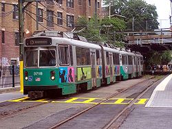
- KenmoreKenmore (MBTA station)Kenmore is an MBTA light rail station in the Kenmore Square area of Boston, Massachusetts, and serves the Green Line B, C, and D branches...
- B, C, D - FenwayFenway (MBTA station)Fenway is a stop on the D branch of the MBTA Green Line. It is located in the Fenway-Kenmore neighborhood of Boston Massachusetts, under Park Drive near The Riverway. Named after the Fenway parkway rather than Fenway Park, it is not the nearest station to the stadium - Yawkey commuter rail and...
- D - St. Mary's StreetSt. Marys Street (MBTA station)St. Marys Street is a stop on the C branch of the Massachusetts Bay Transportation Authority's Green Line, located just west of the intersection of Beacon Street and Park Drive in Boston, Massachusetts....
- C - SymphonySymphony (MBTA station)Symphony is an underground light rail stop in Boston, Massachusetts on the "E" branch of the MBTA Green Line. It is located at the intersection of Massachusetts Avenue and Huntington Avenue...
- E - NortheasternNortheastern University (MBTA station)Northeastern University is a surface-level trolley stop on the MBTA Green Line. It is located in a dedicated median along Huntington Avenue in Boston, between Opera Place and Forsyth Street, and is adjacent to the Krentzman Quad on the campus of Northeastern University...
- E - Museum of Fine ArtsMuseum of Fine Arts (MBTA station)Museum of Fine Arts is a surface-level subway stop on the E branch of the MBTA Green Line. It is located in a dedicated median along Huntington Avenue in Boston, Massachusetts, between Museum Road and Ruggles Street.-Nearby Attractions:...
- E
Yawkey Station
Yawkey (MBTA station)
Yawkey is a station on the MBTA Commuter Rail Framingham/Worcester Line. It is situated near Fenway Park, Boston University and the Longwood Medical and Academic Area in the Fenway-Kenmore section of Boston....
on the Framingham/Worcester Line
Framingham/Worcester Line
The Framingham/Worcester Line is a railroad line of the MBTA Commuter Rail system, running west from Boston, Massachusetts to Worcester, Massachusetts, though some trains terminate at Framingham, Massachusetts...
of the MBTA Commuter Rail
MBTA Commuter Rail
The MBTA Commuter Rail serves as the regional rail arm of the Massachusetts Bay Transportation Authority, in the United States. It is operated under contract by the Massachusetts Bay Commuter Railroad Company a joint partnership of Veolia Transportation, Bombardier Transportation and Alternate...
is located near Fenway Park and Kenmore Square and provides limited inbound and outbound stops for commuters during rush hour. Fenway–Kenmore is also served by a number of MBTA bus
MBTA Bus
The Massachusetts Bay Transportation Authority operates a large number of bus lines in the greater Boston area. Some routes are for transport within the city; others bring passengers from surrounding areas to stops on the rail lines of the MBTA.The MBTA also operates bus rapid transit service; see...
es connecting it to the city proper and the surrounding neighborhoods and communities.
As for roadways, Fenway and Park Drive
Park Drive (parkway)
Park Drive is a mostly one-way, one- to two-lane parkway in the Fenway-Kenmore neighborhood of Boston that runs along the northern and western edges of the Back Bay Fens before ending at Mountfort Street...
circulate around The Fens. Boylston Street
Boylston Street
Boylston Street is the name of a major east-west thoroughfare in the city of Boston, Massachusetts. Another Boylston Street runs through Boston's western suburbs....
is a major east-west route, as are Beacon Street
Beacon Street
Beacon Street is a major thoroughfare in Boston, Massachusetts and several of its western suburbs. Beacon Street in Boston, Brookline, Brighton, and Newton is not to be confused with the Beacon Street in nearby Somerville, or others elsewhere.-Description:...
and Commonwealth Avenue
Commonwealth Avenue, Boston
Commonwealth Avenue is a major street in the cities of Boston and Newton, Massachusetts. It begins at the western edge of the Public Garden, and continues west through the neighborhoods of the Back Bay, Kenmore Square, Allston, Brighton and Chestnut Hill...
, which intersect at Kenmore Square
Kenmore Square
Kenmore Square is a square in Boston, Massachusetts, United States, consisting of the intersection of several main avenues as well as several other cross streets, and Kenmore Station, an MBTA subway stop. Kenmore Square is close to or abuts Boston University, Fenway Park, and Lansdowne Street, a...
. Brookline Avenue
Brookline Avenue
Brookline Avenue is a principal urban artery in the city of Boston, Massachusetts, terminating in the town of Brookline. The Landmark Center, Fenway Park, Emmanuel College, Longwood Medical and Academic Area and Kenmore Square are sites along its length...
begins in Kenmore Square at this intersection and proceeds southwest. Huntington Avenue (MA Route 9) is on the southern border, while Massachusetts Avenue
Massachusetts Avenue (Boston)
Massachusetts Avenue, known to locals as Mass Ave, is a major thoroughfare in Boston, Massachusetts, and several cities and towns northwest of Boston...
forms the eastern border, and is a major north-south route. Although the Massachusetts Turnpike
Massachusetts Turnpike
The Massachusetts Turnpike is the easternmost stretch of Interstate 90. The Turnpike begins at the western border of Massachusetts in West Stockbridge connecting with the Berkshire Connector portion of the New York State Thruway...
cuts through the neighborhood, there are no access points to it except westbound only at Massachusetts Avenue and Newbury Street.