

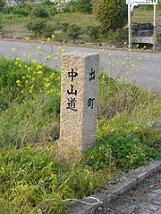
Nakasendo
Encyclopedia
Edo Five Routes
The were the five major roads that started at Edo during the Edo period, the most important of which was the Tōkaidō, which linked Edo and Kyoto...
of the Edo period
Edo period
The , or , is a division of Japanese history which was ruled by the shoguns of the Tokugawa family, running from 1603 to 1868. The political entity of this period was the Tokugawa shogunate....
, and one of the two that connected Edo
Edo
, also romanized as Yedo or Yeddo, is the former name of the Japanese capital Tokyo, and was the seat of power for the Tokugawa shogunate which ruled Japan from 1603 to 1868...
(modern-day Tokyo
Tokyo
, ; officially , is one of the 47 prefectures of Japan. Tokyo is the capital of Japan, the center of the Greater Tokyo Area, and the largest metropolitan area of Japan. It is the seat of the Japanese government and the Imperial Palace, and the home of the Japanese Imperial Family...
) to Kyoto
Kyoto
is a city in the central part of the island of Honshū, Japan. It has a population close to 1.5 million. Formerly the imperial capital of Japan, it is now the capital of Kyoto Prefecture, as well as a major part of the Osaka-Kobe-Kyoto metropolitan area.-History:...
in Japan
Japan
Japan is an island nation in East Asia. Located in the Pacific Ocean, it lies to the east of the Sea of Japan, China, North Korea, South Korea and Russia, stretching from the Sea of Okhotsk in the north to the East China Sea and Taiwan in the south...
. There were 69 stations
69 Stations of the Nakasendo
The are the rest areas along the Nakasendō, which ran from Nihonbashi in Edo to Sanjō Ōhashi in Kyoto. The route stretched approximately and was an alternate trade route to the Tōkaidō.-Stations of the Nakasendō:...
between Edo and Kyoto, crossing through Musashi
Musashi Province
was a province of Japan, which today comprises Tokyo Prefecture, most of Saitama Prefecture and part of Kanagawa Prefecture. It was sometimes called . The province encompassed Kawasaki and Yokohama...
, Kōzuke
Kozuke Province
was an old province located in the Tōsandō of Japan, which today comprises Gunma Prefecture. It is nicknamed as or .The ancient provincial capital was near modern Maebashi. During the Sengoku period, Kōzuke was controlled variously by Takeda Shingen, Uesugi Kenshin, the late Hōjō clan, and...
, Shinano
Shinano Province
or is an old province of Japan that is now present day Nagano Prefecture.Shinano bordered on Echigo, Etchū, Hida, Kai, Kōzuke, Mikawa, Mino, Musashi, Suruga, and Tōtōmi Provinces...
, Mino
Mino Province
, one of the old provinces of Japan, encompassed part of modern-day Gifu Prefecture. It was sometimes called . Mino Province bordered Echizen, Hida, Ise, Mikawa, Ōmi, Owari, and Shinano Provinces....
and Ōmi
Omi Province
is an old province of Japan, which today comprises Shiga Prefecture. It was one of the provinces that made up the Tōsandō circuit. It is nicknamed as .Lake Biwa, Japan's largest lake, is located at the center of the province...
provinces. In addition to Tokyo and Kyoto, the Nakasendō runs through the modern-day prefectures of Saitama
Saitama Prefecture
is a prefecture of Japan located in the Kantō region of the island of Honshu. The capital is the city of Saitama.This prefecture is part of the Greater Tokyo Area, and most of Saitama's cities can be described as suburbs of Tokyo, to which a large amount of residents commute each day.- History...
, Gunma
Gunma Prefecture
is a prefecture of Japan located in the northwest corner of the Kantō region on Honshu island. Its capital is Maebashi.- History :The remains of a Paleolithic man were found at Iwajuku, Gunma Prefecture, in the early 20th century and there is a public museum there.Japan was without horses until...
, Nagano
Nagano Prefecture
is a prefecture of Japan located in the Chūbu region of the island of Honshū. The capital is the city of Nagano.- History :Nagano was formerly known as the province of Shinano...
, Gifu
Gifu Prefecture
is a prefecture located in the Chūbu region of central Japan. Its capital is the city of Gifu.Located in the center of Japan, it has long played an important part as the crossroads of Japan, connecting the east to the west through such routes as the Nakasendō...
and Shiga
Shiga Prefecture
is a prefecture of Japan, which forms part of the Kansai region on Honshu Island. The capital is the city of Ōtsu.- History :Shiga was known as Ōmi Province or Gōshū before the prefectural system was established...
, with a total distance of approximately 534 km (332 mi).
Unlike the coastal Tōkaidō
Tokaido (road)
The ' was the most important of the Five Routes of the Edo period, connecting Edo to Kyoto in Japan. Unlike the inland and less heavily travelled Nakasendō, the Tōkaidō travelled along the sea coast of eastern Honshū, hence the route's name....
, the Nakasendō traveled inland, hence its name, which can be translated as "central mountain route" (as opposed to the Tōkaidō, which roughly meant "eastern sea route"). Because it was such a well-developed road, many famous persons, including the haiku
Haiku
' , plural haiku, is a very short form of Japanese poetry typically characterised by three qualities:* The essence of haiku is "cutting"...
master Matsuo Bashō
Matsuo Basho
, born , then , was the most famous poet of the Edo period in Japan. During his lifetime, Bashō was recognized for his works in the collaborative haikai no renga form; today, after centuries of commentary, he is recognized as a master of brief and clear haiku...
, traveled the road. Many people preferred traveling along the Nakasendō because it did not require travelers to ford any rivers.
Ritsuryō
Around the beginning of the seventh century, during the beginning of RitsuryōRitsuryo
is the historical law system based on the philosophies of Confucianism and Chinese Legalism in Japan. The political system in accord to Ritsuryō is called "Ritsuryō-sei"...
, the area that would eventually make up the Nakasendō was developed to connect Kinai
Kinai
is a Japanese term denoting an ancient division of the country. Kinai is a name for the ancient provinces around the capital Nara and Heian-kyō. The five provinces were called go-kinai after 1760....
(modern-day Kansai region, which included the former capital of Japan) with the provinces of the Tōsandō
Tosando
was an old Japanese geographical region that made up the gokishichidō system and was situated along the central mountains of northern Honshū, Tōhoku region....
(part of the gokishichidō
Gokishichido
was the name for ancient administrative units organized in Japan during the Asuka Period , as part of a legal and governmental system borrowed from the Chinese...
) that lie to the east.
Sengoku period
During the Sengoku periodSengoku period
The or Warring States period in Japanese history was a time of social upheaval, political intrigue, and nearly constant military conflict that lasted roughly from the middle of the 15th century to the beginning of the 17th century. The name "Sengoku" was adopted by Japanese historians in reference...
, which lasted from the 15th to 17th centuries, the Tōsandō was controlled by the Takeda (Kai Province
Kai Province
, also known as , is an old province in Japan in the area of Yamanashi Prefecture. It lies in central Honshū, west of Tokyo, in a landlocked mountainous region that includes Mount Fuji along its border with Shizuoka Prefecture....
), Ogasawara
Ogasawara clan
The was a Japanese samurai clan descended from the Seiwa Genji. The Ogasawara acted as shugo of Shinano province in the medieval period The was a Japanese samurai clan descended from the Seiwa Genji. The Ogasawara acted as shugo (governors) of Shinano province in the medieval period The was a...
(Shinano Province
Shinano Province
or is an old province of Japan that is now present day Nagano Prefecture.Shinano bordered on Echigo, Etchū, Hida, Kai, Kōzuke, Mikawa, Mino, Musashi, Suruga, and Tōtōmi Provinces...
), Kanamori
Kanamori clan
The was a Japanese clan during the Sengoku period that descended from Seiwa Genji through Hida Province's Toki clan. This clan ruled over the Hida-Takayama Domain during the Sengoku period.-History:One of Toki Sadayori was also known as Ōhata Sadayori...
(Hida Province
Hida Province
is an old province located in the area of Gifu Prefecture. It was sometimes called . The province was in the Tōsandō area of central Honshu.-History:...
) and Oda
Oda clan
The was a family of Japanese daimyo who were to become an important political force in the unification of Japan in the mid-16th century. Though they had the climax of their fame under Oda Nobunaga and fell from the spotlight soon after, several branches of the family would continue on as daimyo...
(Mino Province
Mino Province
, one of the old provinces of Japan, encompassed part of modern-day Gifu Prefecture. It was sometimes called . Mino Province bordered Echizen, Hida, Ise, Mikawa, Ōmi, Owari, and Shinano Provinces....
) clans
Japanese clans
This is a list of Japanese clans. The ancient clans mentioned in the Nihonshoki and Kojiki lost their political power before the Heian period. Instead of gozoku, new aristocracies, Kuge families emerged in the period...
. In order to connect the Tōsandō with the Tōkaidō
Tokaido (region)
The was originally an old Japanese geographical region that made up the gokishichidō system and was situated along the southeastern edge of Honshū, its name literally meaning 'Eastern Sea Way'....
(and Takeda's troops with Oda's), a road system was developed. This route is generally followed by the modern day national highways
National highways of Japan
Japan has a nationwide system of distinct from the expressways. The Ministry of Land, Infrastructure and Transport and other government agencies administer the national highways. Beginning in 1952, Japan classified these as Class 1 or Class 2. Class 1 highways had one- or two-digit numbers, while...
numbered 52
Japan National Route 52
National Route 52 is a national highway of Japan connecting Shimizu-ku, Shizuoka and Kōfu, Yamanashi in Japan, with a total length of 100.1 km ....
, 151, 153, and 22
Japan National Route 22
is a national highway connecting Nagoya, Aichi Prefecture, and Gifu, Gifu Prefecture in Japan. The route follows the old Minoji, a 17th century trade route that connected the Nakasendō and the Tōkaidō.-Route data:*Length:...
.
Creation of the Nakasendō
Edo period
The , or , is a division of Japanese history which was ruled by the shoguns of the Tokugawa family, running from 1603 to 1868. The political entity of this period was the Tokugawa shogunate....
, many political, legal, cultural and intellectual changes took place. Among them was the rejuvenation of Japan's thousand-year-old highway system. Five roads were formally nominated as official routes for the use of the shogun
Shogun
A was one of the hereditary military dictators of Japan from 1192 to 1867. In this period, the shoguns, or their shikken regents , were the de facto rulers of Japan though they were nominally appointed by the emperor...
and the other daimyo
Daimyo
is a generic term referring to the powerful territorial lords in pre-modern Japan who ruled most of the country from their vast, hereditary land holdings...
and to provide the Tokugawa shogunate
Tokugawa shogunate
The Tokugawa shogunate, also known as the and the , was a feudal regime of Japan established by Tokugawa Ieyasu and ruled by the shoguns of the Tokugawa family. This period is known as the Edo period and gets its name from the capital city, Edo, which is now called Tokyo, after the name was...
with the communications network that it needed to stabilize and rule the country. One of these five roads was the Nakasendō, which stretched from Edo
Edo
, also romanized as Yedo or Yeddo, is the former name of the Japanese capital Tokyo, and was the seat of power for the Tokugawa shogunate which ruled Japan from 1603 to 1868...
, from where the shogun wielded the real power, through the central mountain ranges of Honshū
Honshu
is the largest island of Japan. The nation's main island, it is south of Hokkaido across the Tsugaru Strait, north of Shikoku across the Inland Sea, and northeast of Kyushu across the Kanmon Strait...
and on to Kyoto.
Until the establishment of these formal trade routes, many shorter routes had existed, connecting towns over various distances. One such route was the Kisoji
Kisoji
The was an old trade route in the Kiso Valley that stretched from Niekawa-juku in Nagano Prefecture to Magome-juku in Gifu Prefecture. There were eleven resting spots along the route, all of which became part of the Nakasendō when it was established...
, which had all eleven post towns become part of the Nakasendō (from Niekawa-juku
Niekawa-juku
was the thirty-third of the sixty-nine stations of the Nakasendō. It is located in the present-day city of Shiojiri, Nagano Prefecture, Japan.-History:...
to Magome-juku). Prior to the Edo period, the route had been called both "Sandō" (山道 mountain route) and "Tōsandō" (東山道 eastern mountain route). During the Edo Period, the name was changed to Nakasendō and was written as both 中山道 and 中仙道, but the Tokugawa Shogunate established 中山道 as the official name in 1716.
Today
Kiso Valley
The is a geographical area that centers on the valley of the upper portions of the Kiso River in the southwestern part of Nagano Prefecture in Japan...
, between Tsumago-juku in Nagano Prefecture and Magome-juku in Gifu Prefecture. The area was first made famous by the early 20th-century writer Shimazaki Tōson
Shimazaki Toson
is the pen-name of Shimazaki Haruki, a Japanese author, active in the Meiji, Taishō and early Shōwa periods of Japan. He began his career as a romantic poet, but went on to establish himself as a major proponent of naturalism in Japanese fiction.-Early life:...
, who chronicled the effects of the Meiji Restoration
Meiji Restoration
The , also known as the Meiji Ishin, Revolution, Reform or Renewal, was a chain of events that restored imperial rule to Japan in 1868...
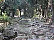
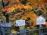
on the valley in his landmark novel Before the Dawn. This eight-kilometer section of the Nakasendō can still be travelled along comfortably by foot, and both Tsumago-juku and Magome-juku have preserved and restored the traditional architecture. The walk between the historical post towns requires two to three hours to walk, with forests, restored paving and fine views of waterfalls along the way.
Although much of the Nakasendō no longer exists in its historic form, its route is now roughly followed by modern roads. In order, they are:
- Route 17: TokyoTokyo, ; officially , is one of the 47 prefectures of Japan. Tokyo is the capital of Japan, the center of the Greater Tokyo Area, and the largest metropolitan area of Japan. It is the seat of the Japanese government and the Imperial Palace, and the home of the Japanese Imperial Family...
to TakasakiTakasaki, Gunmais a city located in Gunma Prefecture, Japan.The city was founded on April 1, 1900.Takasaki is a regional transportation hub because its train station is the junction of several rail lines as well as a Shinkansen stop....
(Gunma PrefectureGunma Prefectureis a prefecture of Japan located in the northwest corner of the Kantō region on Honshu island. Its capital is Maebashi.- History :The remains of a Paleolithic man were found at Iwajuku, Gunma Prefecture, in the early 20th century and there is a public museum there.Japan was without horses until...
) - Route 18Japan National Route 18National Route 18 is a national highway connecting Takasaki, Gunma and Joetsu, Niigata in Japan.-Route Data:*Length: 193.9 km *Origin: Takasaki City...
: Takasaki to KaruizawaKaruizawa, Naganois a town located in Kitasaku District, Nagano, Japan.As of January 1, 2008, the town has an estimated population of 17,833 and has a total area of ....
(Nagano PrefectureNagano Prefectureis a prefecture of Japan located in the Chūbu region of the island of Honshū. The capital is the city of Nagano.- History :Nagano was formerly known as the province of Shinano...
) - Route 142: SakuSaku, Naganois a city located in Nagano, Japan.Due to the refounding of Saku back on April 1, 2005, the city became the fifth city in Nagano Prefecture to go over 100,000...
to ShimosuwaShimosuwa, Naganois a town located in Suwa District, Nagano, Japan. It is located on Lake Suwa, a large, natural lake surrounded by mountains.As of 2006, the town has an estimated population of 22,421. The total area is 66.90 km²....
(Nagano Prefecture) - Route 20: Shimosuwa to ShiojiriShiojiri, Naganois a city located in Nagano, Japan. Its name literally means "the end of salt".-History:Municipal Area Changes* April 1, 1927-The village of Shiojiri gained town status....
(Nagano Prefecture) - Route 19Japan National Route 19National Route 19 is a national highway connecting Nagoya and Nagano in Japan.-Route Data:*Length: 258.9 km *Origin: Atsuta-ku, Nagoya, Nagoya *Terminus: Nagano City...
: Shiojiri to EnaEna, Gifuis a city located in the Tōnō region of Gifu Prefecture, Japan. As of July 2011, the city has an estimated population of 53,378. The total area is 504.19 km²....
(Gifu PrefectureGifu Prefectureis a prefecture located in the Chūbu region of central Japan. Its capital is the city of Gifu.Located in the center of Japan, it has long played an important part as the crossroads of Japan, connecting the east to the west through such routes as the Nakasendō...
) - Route 21Japan National Route 21is a national highway connecting Mizunami, Gifu Prefecture and Maibara, Shiga Prefecture in Japan.-Route Data:*Length: *Origin: Mizunami *Terminus: Maibara...
: MitakeMitake, Gifuis a town located in Kani District, Gifu Prefecture, Japan.As of July 2011, the town had an estimated population of 18,709. The total area is 56.61 km².-Rail:*Nagoya Railroad**Hiromi Line - Gōdo, Mitakeguchi, Mitake-External links:*...
(Gifu Prefecture) to MaibaraMaibara, Shigais a city located in Shiga Prefecture, Japan.As of August 1, 2006, the city has an estimated population of 42,154. The total area is 223.1 km².- History :...
(Shiga PrefectureShiga Prefectureis a prefecture of Japan, which forms part of the Kansai region on Honshu Island. The capital is the city of Ōtsu.- History :Shiga was known as Ōmi Province or Gōshū before the prefectural system was established...
) - Route 8: Maibara to KusatsuKusatsu, Shigais a city located in Shiga Prefecture, Japan. The city was founded on October 15, 1954, and as of 2008, the city has an estimated population of 123,690 and the density of 1,820 persons per km². The total area is 67.92 km².- Overview :...
(Shiga Prefecture) - Route 1: Kusatsu to KyotoKyotois a city in the central part of the island of Honshū, Japan. It has a population close to 1.5 million. Formerly the imperial capital of Japan, it is now the capital of Kyoto Prefecture, as well as a major part of the Osaka-Kobe-Kyoto metropolitan area.-History:...
There are also modern railways that follow the Nakasendō's path and they are the Takasaki Line
Takasaki Line
The is a Japanese railway line which runs between Ōmiya Station in Saitama, Saitama Prefecture and Takasaki Station in Takasaki, Gunma Prefecture. It is owned and operated by the East Japan Railway Company ....
, Shinetsu Main Line, Chūō Main Line
Chuo Main Line
The , commonly called the Chūō Line, is one of the major trunk railway lines in Japan. It runs between Tokyo and Nagoya, although it is the slowest direct railway connection between the two cities; the coastal Tōkaidō Main Line is slightly faster, while the Tōkaidō Shinkansen is the fastest rail...
, Taita Line
Taita Line
The is part of the Central Japan Railway Company network in Gifu Prefecture, Japan. It operates from Tajimi Station in the city of Tajimi through Kani to Mino-Ōta Station in Minokamo...
and Tōkaidō Main Line
Tokaido Main Line
The is the busiest trunk line of the Japan Railways Group , connecting Tōkyō and Kōbe stations. It is long, not counting its many freight feeder lines around the major cities...
.
See also
- 69 Stations of the Nakasendō69 Stations of the NakasendoThe are the rest areas along the Nakasendō, which ran from Nihonbashi in Edo to Sanjō Ōhashi in Kyoto. The route stretched approximately and was an alternate trade route to the Tōkaidō.-Stations of the Nakasendō:...
- TōsandōTosandowas an old Japanese geographical region that made up the gokishichidō system and was situated along the central mountains of northern Honshū, Tōhoku region....
- Edo Five RoutesEdo Five RoutesThe were the five major roads that started at Edo during the Edo period, the most important of which was the Tōkaidō, which linked Edo and Kyoto...
- TōkaidōTokaido (road)The ' was the most important of the Five Routes of the Edo period, connecting Edo to Kyoto in Japan. Unlike the inland and less heavily travelled Nakasendō, the Tōkaidō travelled along the sea coast of eastern Honshū, hence the route's name....
- Kōshū KaidōKoshu KaidoThe was one of the five routes of the Edo period and it was built to connect Edo with Kai Province in modern-day Yamanashi Prefecture, Japan. The route continues from there to connect with the Nakasendō's Shimosuwa-shuku in Nagano Prefecture...
- Ōshū KaidōOshu KaidoThe was one of the five routes of the Edo period and it was built to connect Edo with Mutsu Province and the present-day city of Shirakawa, Fukushima Prefecture, Japan...
- Nikkō KaidōNikko KaidoThe was one of the five routes of the Edo period and it was built to connect Edo with the Nikkō Tōshō-gū, which is located in the present-day city of Nikkō, Tochigi Prefecture, Japan. It was established in 1617 by Tokugawa Ieyasu, in order for him to have a smoother route to the shrine...
- Tōkaidō