

Gokishichido
Encyclopedia
Asuka period
The , was a period in the history of Japan lasting from 538 to 710 , although its beginning could be said to overlap with the preceding Kofun period...
(AD 538–710), as part of a legal and governmental system
Ritsuryo
is the historical law system based on the philosophies of Confucianism and Chinese Legalism in Japan. The political system in accord to Ritsuryō is called "Ritsuryō-sei"...
borrowed from the Chinese. Though these units did not survive as administrative structures beyond the Muromachi Period
Muromachi period
The is a division of Japanese history running from approximately 1336 to 1573. The period marks the governance of the Muromachi or Ashikaga shogunate, which was officially established in 1338 by the first Muromachi shogun, Ashikaga Takauji, two years after the brief Kemmu restoration of imperial...
(1336–1573), they did remain important geographical entities up until the 19th century.
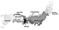
The Gokishichidō consisted of five provinces in the Kinai
Kinai
is a Japanese term denoting an ancient division of the country. Kinai is a name for the ancient provinces around the capital Nara and Heian-kyō. The five provinces were called go-kinai after 1760....
(畿内) or capital region, plus seven dō (道) or circuits, each of which contained provinces
Provinces of Japan
Before the modern prefecture system was established, the land of Japan was divided into tens of kuni , usually known in English as provinces. Each province was divided into gun ....
of its own.
Five Provinces
The five Kinai provinces were local areas in and around the imperial capital (first Heijō-kyō at NaraNara, Nara
is the capital city of Nara Prefecture in the Kansai region of Japan. The city occupies the northern part of Nara Prefecture, directly bordering Kyoto Prefecture...
, then Heian-kyō at Kyōto). They were:
- Yamato ProvinceYamato Provincewas a province of Japan, located in Kinai, corresponding to present-day Nara Prefecture in Honshū. It was also called . At first, the name was written with one different character , and for about ten years after 737, this was revised to use more desirable characters . The final revision was made in...
(now Nara PrefectureNara Prefectureis a prefecture in the Kansai region on Honshū Island, Japan. The capital is the city of Nara.-History:The present-day Nara Prefecture was created in 1887, making it independent of Osaka Prefecture....
) - Yamashiro ProvinceYamashiro Provincewas a province of Japan, located in Kinai. It overlaps the southern part of modern Kyoto Prefecture on Honshū. Aliases include , the rare , and . It is classified as an upper province in the Engishiki....
(now the southern part of Kyōto PrefectureKyoto Prefectureis a prefecture of Japan located in the Kansai region of the island of Honshu. The capital is the city of Kyoto.- History :Until the Meiji Restoration, the area of Kyoto prefecture was known as Yamashiro....
, including the city of Kyōto) - Kawachi ProvinceKawachi Provincewas a province of Japan in the eastern part of modern Osaka Prefecture. It originally held the southwestern area that was split off into Izumi Province...
(now the southeastern part of Osaka PrefectureOsaka Prefectureis a prefecture located in the Kansai region on Honshū, the main island of Japan. The capital is the city of Osaka. It is the center of Osaka-Kobe-Kyoto area.- History :...
) - Settsu ProvinceSettsu Provincewas a province of Japan, which today comprises the eastern part of Hyōgo Prefecture and the northern part of Osaka Prefecture. It was also referred to as or .Osaka and Osaka Castle were the main center of the province.-History:...
(now the northern part of Osaka PrefectureOsaka Prefectureis a prefecture located in the Kansai region on Honshū, the main island of Japan. The capital is the city of Osaka. It is the center of Osaka-Kobe-Kyoto area.- History :...
, including the city of Osaka, and parts of Hyōgo PrefectureHyogo Prefectureis a prefecture of Japan located in the Kansai region on Honshū island. The capital is Kobe.The prefecture's name was previously alternately spelled as Hiogo.- History :...
) - Izumi ProvinceIzumi Provincewas a province of Japan. It is also referred to as . It lay in Kinai, and its area today composes the south-western part of Osaka Prefecture . The Ōshōji in Sakai was the border with Settsu Province, until the beginning of the Meiji period, when the boundary was changed to be at the Yamato River...
(now the southern part of Osaka PrefectureOsaka Prefectureis a prefecture located in the Kansai region on Honshū, the main island of Japan. The capital is the city of Osaka. It is the center of Osaka-Kobe-Kyoto area.- History :...
)
Seven Circuits
The seven dō or circuits were administrative areas stretching away from the Kinai region in different directions. Running through each of the seven areas was an actual road of the same name, connecting the imperial capital with all of the provincial capitals along its route. The seven dō were:- TōkaidōTokaido (region)The was originally an old Japanese geographical region that made up the gokishichidō system and was situated along the southeastern edge of Honshū, its name literally meaning 'Eastern Sea Way'....
(running east along Japan's Pacific coast). - TōsandōTosandowas an old Japanese geographical region that made up the gokishichidō system and was situated along the central mountains of northern Honshū, Tōhoku region....
(northeast through the Japanese AlpsJapanese AlpsThe is a series of mountain ranges in Japan that bisect the main island of Honshū. The name was coined by William Gowland, the "Father of Japanese Archaeology," and later popularized by Reverend Walter Weston , an English missionary for whom a memorial plaque is located at Kamikochi, a tourist...
). - HokurikudōHokurikudois a Japanese term denoting both an ancient division of the country and the main road running through the old Japanese geographical region. Both were situated along the northwestern edge of Honshū. The name literally means 'North Land Way'...
(northeast along the Sea of JapanSea of JapanThe Sea of Japan is a marginal sea of the western Pacific Ocean, between the Asian mainland, the Japanese archipelago and Sakhalin. It is bordered by Japan, North Korea, Russia and South Korea. Like the Mediterranean Sea, it has almost no tides due to its nearly complete enclosure from the Pacific...
coast). - San'indōSan'indois a Japanese term denoting both an ancient division of the country and the main road running through it. San'in translates to "the shaded side of a mountain", while dō, depending on the context, can mean either a road, or a circuit, in the sense of delineating a region...
(west along the Sea of JapanSea of JapanThe Sea of Japan is a marginal sea of the western Pacific Ocean, between the Asian mainland, the Japanese archipelago and Sakhalin. It is bordered by Japan, North Korea, Russia and South Korea. Like the Mediterranean Sea, it has almost no tides due to its nearly complete enclosure from the Pacific...
coast). - San'yōdōSan'yodois a Japanese term denoting both an ancient division of the country and the main road running through it. The San'yōdō corresponds for the most part with the modern conception of the San'yō region,San'yō translates to "the sunlight-side of a mountain", while dō, depending on the context, can mean...
(west along the northern side of the Seto Inland Sea). - NankaidōNankaidoThe , literally meaning "southern sea road," is a Japanese term denoting both an ancient division of the country and the main road running through it. The road connected provincial capitals in this region...
(south to the Kii PeninsulaKii PeninsulaThe is the largest peninsula on the island of Honshū in Japan. The area south of the “Central Tectonic Line” is called Nankii , and includes the most poleward living coral reefs in the world due to the presence of the warm Kuroshio Current, though these are threatened by global warming and human...
and the islands of AwajiAwaji Islandis an island in Hyōgo Prefecture, Japan, in the eastern part of the Seto Inland Sea between the islands of Honshū and Shikoku. The island has an area of 592.17 km²...
and ShikokuShikokuis the smallest and least populous of the four main islands of Japan, located south of Honshū and east of the island of Kyūshū. Its ancient names include Iyo-no-futana-shima , Iyo-shima , and Futana-shima...
). - SaikaidōSaikaido, literally meaning "western sea circuit," is a Japanese term denoting both an ancient division of the country and the main road running through it. Saikaido was one of the main circuits of the Gokishichidō system, which was originally established during the Asuka Period.This name identified the...
(the “western” island, KyūshūKyushuis the third largest island of Japan and most southwesterly of its four main islands. Its alternate ancient names include , , and . The historical regional name is referred to Kyushu and its surrounding islands....
).
Gokaidō
The Gokishichidō roads should not be confused with the Edo Five RoutesEdo Five Routes
The were the five major roads that started at Edo during the Edo period, the most important of which was the Tōkaidō, which linked Edo and Kyoto...
(五街道 Gokaidō), which were the five major roads leading to Edo
Edo
, also romanized as Yedo or Yeddo, is the former name of the Japanese capital Tokyo, and was the seat of power for the Tokugawa shogunate which ruled Japan from 1603 to 1868...
during the Edo Period
Edo period
The , or , is a division of Japanese history which was ruled by the shoguns of the Tokugawa family, running from 1603 to 1868. The political entity of this period was the Tokugawa shogunate....
(1603–1867). The Tōkaidō (road)
Tokaido (road)
The ' was the most important of the Five Routes of the Edo period, connecting Edo to Kyoto in Japan. Unlike the inland and less heavily travelled Nakasendō, the Tōkaidō travelled along the sea coast of eastern Honshū, hence the route's name....
was one of the five routes, but the others were not.
Regional perimeters
At the right, the graphic illustration of the ancient geographic regions presents a modern formulation of an ancient map. The straightforward modification of a current prefectural map is helpful because it makes use of a familiar template; however, this helpful graphic is somewhat misleading because it implies a too-simple congruence between the current prefectural boundaries and the inevitable "fuzzy logic" of regional boundaries.A few Japanese regions, such as Hokuriku
Hokuriku region
The is located in the northwestern part of Honshū, the main island of Japan. It lies along the Sea of Japan within the Chūbu region. It is almost equivalent to Koshi Province and Hokurikudō area in pre-modern Japan....
and San'yō, still retain their ancient Gokishichidō names. Other parts of Japan, namely Hokkaidō
Hokkaido
, formerly known as Ezo, Yezo, Yeso, or Yesso, is Japan's second largest island; it is also the largest and northernmost of Japan's 47 prefectural-level subdivisions. The Tsugaru Strait separates Hokkaido from Honshu, although the two islands are connected by the underwater railway Seikan Tunnel...
and the Ryukyu Islands
Ryukyu Islands
The , also known as the , is a chain of islands in the western Pacific, on the eastern limit of the East China Sea and to the southwest of the island of Kyushu in Japan. From about 1829 until the mid 20th century, they were alternately called Luchu, Loochoo, or Lewchew, akin to the Mandarin...
, were never included in the Gokishichidō because they were not colonized by Japan until the 19th century, just as the Gokishichidō geographic divisions and the feudal han
Han (Japan)
The or domain was the name of the estate belonging to a warrior in Japan after the 17th century. The fiefs of the daimyos of the samurai class of Japan during the Edo period were called han.-Edo period:...
(藩) domains were being replaced with the modern system of prefectures
Prefectures of Japan
The prefectures of Japan are the country's 47 subnational jurisdictions: one "metropolis" , Tokyo; one "circuit" , Hokkaidō; two urban prefectures , Osaka and Kyoto; and 43 other prefectures . In Japanese, they are commonly referred to as...
. Initially the government tried to organize Hokkaidō as an eighth dō (hence the name), but it was soon consolidated into a single prefecture. More information can be found at Wikipedia's Provinces of Japan
Provinces of Japan
Before the modern prefecture system was established, the land of Japan was divided into tens of kuni , usually known in English as provinces. Each province was divided into gun ....
article.
See also
- Comparison of past and present administrative divisions of Japan
- Station bellStation bellUnder the Japanese ritsuryō system, were bells of red copper issued by the central government or by local provincial government offices to travelling officials or messengers known as . Functioning as a proof of identity, they allowed them to procure horses and labour at post stations...