
.gif)
Mount Hamilton (California)
Encyclopedia
Mount Hamilton is a mountain
in California
's Diablo Range
, in Santa Clara County, California
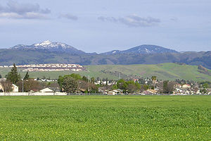
. Mount Hamilton, at 4196 feet (1,279 m) is the tallest mountain overlooking Silicon Valley
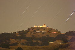
, and is the site of Lick Observatory
, the first permanently occupied mountain-top observatory
. The various summits along its mile-long summit ridge have been given astronomy
-related names. The highest is Copernicus
Peak at 4367 feet (1,331 m). 4250 feet (1,295 m) Kepler
Peak and 4213 feet (1,284 m) Observatory Peak follow. The latter was more than 30 feet (9.1 m) taller before it was leveled during the construction of the observatory in the 1880s. The asteroid
452 Hamiltonia
, discovered in 1899, is named after the mountain. Golden Eagle
nesting sites are found on the slopes of Mount Hamilton.
on the first California Geological Survey
, William H. Brewer
invited local San Jose
preacher
(and Brewer's personal friend) Laurentine Hamilton
to join his company on a trek
to a nearby summit. Nearing completion of their journey, Hamilton, in good humor, bounded for the summit ahead of the rest of the men and claimed his stake. In fact, Brewer suggested the mountain be named after Hamilton only after Whitney declined to have the mountain named after him (a different mountain was later named Mount Whitney
).
The Spanish name for Mt. Hamilton was the Sierra de Santa Isabel and the highest point was originally known as Mount Isabel instead of Mount Hamilton. William Brewer
and his fellow geologist, Charles F. Hoffmann
, did not know it already had a name, and christened it Mt. Hamilton, although they did correctly place Isabel Valley on their map to the east. When in 1895, the USGS
realized that the peak two miles southeast of Mt. Hamilton was as tall (4193 feet (1,278 m), they correctly named it Mt. Isabel.
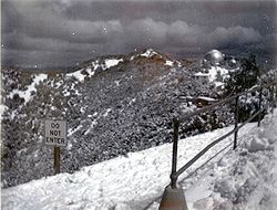
 These mountains are high enough to receive snowfall in the winter, perhaps up to a dozen times. Occasionally, when a cold, wet storm comes in from the Gulf of Alaska
or Canada
, Mt. Hamilton and the surrounding peaks get serious snowfall. In February 2001, 30 inches (76.2 cm) of snow fell, and in March 2006, the peak was left with over a foot (30 cm) of snow
in one night.
The National Weather Service
has had a cooperative weather station on the summit of Mount Hamilton almost since the time that the Lick Observatory opened. It has provided a glimpse of the extreme weather conditions that occur on the Diablo Range, especially in the winter months.
 January is usually the coldest month on Mount Hamilton with an average high of 49.4 °F (9.7 °C) and an average low of 37.5 °F (3.1 °C). The warmest month is usually July with an average high of 78.2 °F (25.7 °C) and an average low of 63.1 °F (17.3 °C). Due to frequent thermal inversions during the summer, it is often warmer on Mount Hamilton than in San Jose. The record high temperature of 103 °F (39.4 °C) was on August 5, 1978. The record low temperature of 7 °F (-13.9 °C) was on December 21, 1990. The average days with highs of 90 °F (32.2 °C) or higher is 4.3 days. The average days with lows of 32 °F (0 °C) or lower is 50.6 days.
Annual precipitation averages 23.73 inches (602.7 mm). Measurable rainfall occurs on an average of 71.9 days each year. The most rainfall in a month was 12.13 inches (308.1 mm) in February 1998; no rainfall has been common during the summer months. The maximum rainfall in 24 hours was 6.87 inches (174.5 mm) on December 23, 1955.
Annual snowfall averages 10 inches (25.4 cm). The maximum snowfall in a year was 59 inches (149.9 cm) in 1955. The maximum snowfall in a month was 33.6 inches (85.3 cm) in January 1950. The 24-hour maximum snowfall of 14 inches (35.6 cm) occurred on February 18, 1990. The deepest daily snow depth was 18 inches (45.7 cm) in March 1976. Measurable snow has been recorded in every month from November through June.
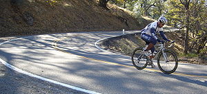
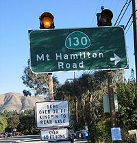 The sinuous 19 miles (30.6 km) Mt. Hamilton Road (part of State Route 130
) is popular with bicyclists and motorcyclists. Built in 1875–76 in anticipation of the observatory, and the need to carry materials and equipment up the mountain in horse-drawn wagons, the grade seldom exceeds 6.5 percent. The road rises over 4000 feet (1,219.2 m) in three long climbs from San Jose to the mountain top. Cyclists fondness for the road relates to the long but not overly challenging nature of the climb, sparse vehicular traffic over most of its length, and spectacular views of San Jose and the rest of the Santa Clara Valley
below. There is an annual cycling challenge climb in April.
Thanksgiving consistently draws hundreds of cyclists and is frequently the final climb in the annual Low-Key Hillclimb Series
which attracts some of the region's best climbers.
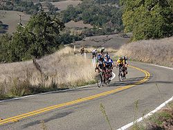 Strong regional climbers can attain the peak in 70–80 minutes starting from Alum Rock Road. On a clear day at the summit it is possible to see the Sierra Nevada. These views do not come without a price, as numerous accidents occur on the road each year. Whenever it snows on Mount Hamilton, the road is closed until crews can clear the road of snow and black ice
.
The 20 miles (32.2 km) drive from Interstate 680
to Lick Observatory takes about 45 minutes.
The bicycle ride is just over 19 miles (30.6 km) from the Alum Rock Road junction. The upward trek is interrupted by two descents, first into Grant Ranch County Park, and again to cross Smith Creek. Quimby Road offers a shorter way from San Jose to Grant Ranch, but is considerably steeper. The main observatory building has water, a few vending machines, restrooms, and an opportunity to warm up on a cold day. If the time is right, there are also free 15-minute guided tours of the Great Lick refracting telescope
, and the gift shop may be open.
 The road is advertised to include 365 curves, one for each day of the year. This is true, subject to definition of the term "curve." If the yellow line bends to the right, then straightens out, then bends to the right again, it is regarded as one curve. If the yellow line describes an ess, on the other hand, it counts as two curves, regardless of how gentle the ess may be.
The road continues, as the San Antonio Valley Road, down the backside of Mount Hamilton, through almost completely empty country, and eventually comes out at Patterson
, in Stanislaus County. Shortly after the summit, one can turn to the north and proceed on Old Mines Road, which ends at Livermore
. There are ranches, farms, several cattle gates along this road, and even a (paved) ford through a shallow stream. Traffic is light to nonexistent.
age sandstone
of the Briones formation: this bedrock
is locally soft and weathered in the upper few feet, but grades locally to very hard at depth. Depth to groundwater
on these foothill areas of Mount Hamilton is approximately 240 feet (73.2 m). The Babb Creek drainage comprises some of the watershed
draining the slopes of Mount Hamilton. The Calaveras and Hayward active earthquake
faults traverse the slopes of Mount Hamilton.
(Streptanthus callistus) is endemic to the area.
 Mount Hamilton has its own zip code, 95140. It is generally open space with a population in 2000 of 35. The area has its own police force (one officer, a member of the University of California police
). Mount Hamilton Elementary is a small, one classroom school with eleven students,
Mountain
Image:Himalaya_annotated.jpg|thumb|right|The Himalayan mountain range with Mount Everestrect 58 14 160 49 Chomo Lonzorect 200 28 335 52 Makalurect 378 24 566 45 Mount Everestrect 188 581 920 656 Tibetan Plateaurect 250 406 340 427 Rong River...
in California
California
California is a state located on the West Coast of the United States. It is by far the most populous U.S. state, and the third-largest by land area...
's Diablo Range
Diablo Range
The Diablo Range is a mountain range in the California Coast Ranges subdivision of the Pacific Coast Ranges. It is located in the eastern San Francisco Bay area south to the Salinas Valley area of northern California, the United States.-Geography:...
, in Santa Clara County, California
Santa Clara County, California
Santa Clara County is a county located at the southern end of the San Francisco Bay Area in the U.S. state of California. As of 2010 it had a population of 1,781,642. The county seat is San Jose. The highly urbanized Santa Clara Valley within Santa Clara County is also known as Silicon Valley...
. Mount Hamilton, at 4196 feet (1,279 m) is the tallest mountain overlooking Silicon Valley
Silicon Valley
Silicon Valley is a term which refers to the southern part of the San Francisco Bay Area in Northern California in the United States. The region is home to many of the world's largest technology corporations...
, and is the site of Lick Observatory
Lick Observatory
The Lick Observatory is an astronomical observatory, owned and operated by the University of California. It is situated on the summit of Mount Hamilton, in the Diablo Range just east of San Jose, California, USA...
, the first permanently occupied mountain-top observatory
Observatory
An observatory is a location used for observing terrestrial or celestial events. Astronomy, climatology/meteorology, geology, oceanography and volcanology are examples of disciplines for which observatories have been constructed...
. The various summits along its mile-long summit ridge have been given astronomy
Astronomy
Astronomy is a natural science that deals with the study of celestial objects and phenomena that originate outside the atmosphere of Earth...
-related names. The highest is Copernicus
Nicolaus Copernicus
Nicolaus Copernicus was a Renaissance astronomer and the first person to formulate a comprehensive heliocentric cosmology which displaced the Earth from the center of the universe....
Peak at 4367 feet (1,331 m). 4250 feet (1,295 m) Kepler
Johannes Kepler
Johannes Kepler was a German mathematician, astronomer and astrologer. A key figure in the 17th century scientific revolution, he is best known for his eponymous laws of planetary motion, codified by later astronomers, based on his works Astronomia nova, Harmonices Mundi, and Epitome of Copernican...
Peak and 4213 feet (1,284 m) Observatory Peak follow. The latter was more than 30 feet (9.1 m) taller before it was leveled during the construction of the observatory in the 1880s. The asteroid
Asteroid
Asteroids are a class of small Solar System bodies in orbit around the Sun. They have also been called planetoids, especially the larger ones...
452 Hamiltonia
452 Hamiltonia
452 Hamiltonia is an asteroid. It was discovered by James Edward Keeler on December 6, 1899, but was then lost until 1987. Its provisional name was 1899 FD. The asteroid is named for Mount Hamilton, the site of Lick Observatory where Keeler was working when he discovered the asteroid.L. K...
, discovered in 1899, is named after the mountain. Golden Eagle
Golden Eagle
The Golden Eagle is one of the best known birds of prey in the Northern Hemisphere. Like all eagles, it belongs to the family Accipitridae. Once widespread across the Holarctic, it has disappeared from many of the more heavily populated areas...
nesting sites are found on the slopes of Mount Hamilton.
History
On August 26, 1861, while working for Josiah D. WhitneyJosiah Whitney
Josiah Dwight Whitney was an American geologist, professor of geology at Harvard University , and chief of the California Geological Survey...
on the first California Geological Survey
California Geological Survey
Although it was not until 1880 that the California State Mining Bureau, predecessor to the California Geological Survey, was established, the "roots" of California's state geological survey date to an earlier time...
, William H. Brewer
William Henry Brewer
William Henry Brewer was an American botanist. He worked on the first California Geological Survey and was the first Chair of Agriculture at Yale University's Sheffield Scientific School....
invited local San Jose
San Jose, California
San Jose is the third-largest city in California, the tenth-largest in the U.S., and the county seat of Santa Clara County which is located at the southern end of San Francisco Bay...
preacher
Preacher
Preacher is a term for someone who preaches sermons or gives homilies. A preacher is distinct from a theologian by focusing on the communication rather than the development of doctrine. Others see preaching and theology as being intertwined...
(and Brewer's personal friend) Laurentine Hamilton
Laurentine Hamilton
Laurentine Hamilton was a Presbyterian minister accused of heresy, and founder of the First Unitarian Church of Oakland....
to join his company on a trek
Hiking
Hiking is an outdoor activity which consists of walking in natural environments, often in mountainous or other scenic terrain. People often hike on hiking trails. It is such a popular activity that there are numerous hiking organizations worldwide. The health benefits of different types of hiking...
to a nearby summit. Nearing completion of their journey, Hamilton, in good humor, bounded for the summit ahead of the rest of the men and claimed his stake. In fact, Brewer suggested the mountain be named after Hamilton only after Whitney declined to have the mountain named after him (a different mountain was later named Mount Whitney
Mount Whitney
Mount Whitney is the highest summit in the contiguous United States with an elevation of . It is on the boundary between California's Inyo and Tulare counties, west-northwest of the lowest point in North America at Badwater in Death Valley National Park...
).
The Spanish name for Mt. Hamilton was the Sierra de Santa Isabel and the highest point was originally known as Mount Isabel instead of Mount Hamilton. William Brewer
William Brewer
William Brewer may refer to:*William Brewer , administrator and justice in England*William Briwere , his nephew, medieval bishop of Exeter*William Henry Brewer , American botanist*William M...
and his fellow geologist, Charles F. Hoffmann
Charles F. Hoffmann
Charles Frederick Hoffmann was a German-American topographer working in California U.S. from 1860 to 1880.-Life:Hoffmann was born in Frankfurt, Germany, 1838. After receiving an education in engineering, he emigrated to America. In 1857 he was topographer for Frederick Lander’s survey to the Rocky...
, did not know it already had a name, and christened it Mt. Hamilton, although they did correctly place Isabel Valley on their map to the east. When in 1895, the USGS
United States Geological Survey
The United States Geological Survey is a scientific agency of the United States government. The scientists of the USGS study the landscape of the United States, its natural resources, and the natural hazards that threaten it. The organization has four major science disciplines, concerning biology,...
realized that the peak two miles southeast of Mt. Hamilton was as tall (4193 feet (1,278 m), they correctly named it Mt. Isabel.
Climate
Gulf of Alaska
The Gulf of Alaska is an arm of the Pacific Ocean defined by the curve of the southern coast of Alaska, stretching from the Alaska Peninsula and Kodiak Island in the west to the Alexander Archipelago in the east, where Glacier Bay and the Inside Passage are found.The entire shoreline of the Gulf is...
or Canada
Canada
Canada is a North American country consisting of ten provinces and three territories. Located in the northern part of the continent, it extends from the Atlantic Ocean in the east to the Pacific Ocean in the west, and northward into the Arctic Ocean...
, Mt. Hamilton and the surrounding peaks get serious snowfall. In February 2001, 30 inches (76.2 cm) of snow fell, and in March 2006, the peak was left with over a foot (30 cm) of snow
Snow
Snow is a form of precipitation within the Earth's atmosphere in the form of crystalline water ice, consisting of a multitude of snowflakes that fall from clouds. Since snow is composed of small ice particles, it is a granular material. It has an open and therefore soft structure, unless packed by...
in one night.
The National Weather Service
National Weather Service
The National Weather Service , once known as the Weather Bureau, is one of the six scientific agencies that make up the National Oceanic and Atmospheric Administration of the United States government...
has had a cooperative weather station on the summit of Mount Hamilton almost since the time that the Lick Observatory opened. It has provided a glimpse of the extreme weather conditions that occur on the Diablo Range, especially in the winter months.
Annual precipitation averages 23.73 inches (602.7 mm). Measurable rainfall occurs on an average of 71.9 days each year. The most rainfall in a month was 12.13 inches (308.1 mm) in February 1998; no rainfall has been common during the summer months. The maximum rainfall in 24 hours was 6.87 inches (174.5 mm) on December 23, 1955.
Annual snowfall averages 10 inches (25.4 cm). The maximum snowfall in a year was 59 inches (149.9 cm) in 1955. The maximum snowfall in a month was 33.6 inches (85.3 cm) in January 1950. The 24-hour maximum snowfall of 14 inches (35.6 cm) occurred on February 18, 1990. The deepest daily snow depth was 18 inches (45.7 cm) in March 1976. Measurable snow has been recorded in every month from November through June.
Mount Hamilton Road
California State Route 130
State Route 130 is a state highway in the U.S. state of California in Santa Clara County. The route runs between San Jose, California, and Mount Hamilton. Much of its length goes through the Diablo Range as Mount Hamilton Road where it is a narrow 2 lane highway...
) is popular with bicyclists and motorcyclists. Built in 1875–76 in anticipation of the observatory, and the need to carry materials and equipment up the mountain in horse-drawn wagons, the grade seldom exceeds 6.5 percent. The road rises over 4000 feet (1,219.2 m) in three long climbs from San Jose to the mountain top. Cyclists fondness for the road relates to the long but not overly challenging nature of the climb, sparse vehicular traffic over most of its length, and spectacular views of San Jose and the rest of the Santa Clara Valley
Santa Clara Valley
The Santa Clara Valley is a valley just south of the San Francisco Bay in Northern California in the United States. Much of Santa Clara County and its county seat, San José, are in the Santa Clara Valley. The valley was originally known as the Valley of Heart’s Delight for its high concentration...
below. There is an annual cycling challenge climb in April.
Thanksgiving consistently draws hundreds of cyclists and is frequently the final climb in the annual Low-Key Hillclimb Series
which attracts some of the region's best climbers.
Black ice
Black ice, sometimes called glare ice or clear ice, refers to a thin coating of glazed ice on a surface.While not truly black, it is virtually transparent, allowing black asphalt/macadam roadways to be seen through it, hence the term "black ice"...
.
The 20 miles (32.2 km) drive from Interstate 680
Interstate 680 (California)
Interstate 680 is a north–south Interstate Highway in Northern California. It curves around the eastern cities of the San Francisco Bay Area from San Jose to Interstate 80 at Cordelia, bypassing cities along the eastern shore of San Francisco Bay such as Oakland and Richmond while serving...
to Lick Observatory takes about 45 minutes.
The bicycle ride is just over 19 miles (30.6 km) from the Alum Rock Road junction. The upward trek is interrupted by two descents, first into Grant Ranch County Park, and again to cross Smith Creek. Quimby Road offers a shorter way from San Jose to Grant Ranch, but is considerably steeper. The main observatory building has water, a few vending machines, restrooms, and an opportunity to warm up on a cold day. If the time is right, there are also free 15-minute guided tours of the Great Lick refracting telescope
James Lick telescope
The James Lick Telescope is an antique refracting 36 inch telescope built in 1889 that can still be viewed through today...
, and the gift shop may be open.
The road continues, as the San Antonio Valley Road, down the backside of Mount Hamilton, through almost completely empty country, and eventually comes out at Patterson
Patterson, California
Patterson is a city in Stanislaus County, California, United States, located off Interstate 5. It is 45 miles southeast of Livermore and part of the Modesto Metropolitan Statistical Area. Patterson is known as the "Apricot Capital of the World"; the town holds an annual Apricot Fiesta to...
, in Stanislaus County. Shortly after the summit, one can turn to the north and proceed on Old Mines Road, which ends at Livermore
Livermore, California
Livermore is a city in Alameda County. The population as of 2010 was 80,968. Livermore is located on the eastern edge of California's San Francisco Bay Area....
. There are ranches, farms, several cattle gates along this road, and even a (paved) ford through a shallow stream. Traffic is light to nonexistent.
Geology and hydrology
Much of the foothill slopes of Mount Hamilton is underlain by MioceneMiocene
The Miocene is a geological epoch of the Neogene Period and extends from about . The Miocene was named by Sir Charles Lyell. Its name comes from the Greek words and and means "less recent" because it has 18% fewer modern sea invertebrates than the Pliocene. The Miocene follows the Oligocene...
age sandstone
Sandstone
Sandstone is a sedimentary rock composed mainly of sand-sized minerals or rock grains.Most sandstone is composed of quartz and/or feldspar because these are the most common minerals in the Earth's crust. Like sand, sandstone may be any colour, but the most common colours are tan, brown, yellow,...
of the Briones formation: this bedrock
Bedrock
In stratigraphy, bedrock is the native consolidated rock underlying the surface of a terrestrial planet, usually the Earth. Above the bedrock is usually an area of broken and weathered unconsolidated rock in the basal subsoil...
is locally soft and weathered in the upper few feet, but grades locally to very hard at depth. Depth to groundwater
Groundwater
Groundwater is water located beneath the ground surface in soil pore spaces and in the fractures of rock formations. A unit of rock or an unconsolidated deposit is called an aquifer when it can yield a usable quantity of water. The depth at which soil pore spaces or fractures and voids in rock...
on these foothill areas of Mount Hamilton is approximately 240 feet (73.2 m). The Babb Creek drainage comprises some of the watershed
Drainage basin
A drainage basin is an extent or an area of land where surface water from rain and melting snow or ice converges to a single point, usually the exit of the basin, where the waters join another waterbody, such as a river, lake, reservoir, estuary, wetland, sea, or ocean...
draining the slopes of Mount Hamilton. The Calaveras and Hayward active earthquake
Earthquake
An earthquake is the result of a sudden release of energy in the Earth's crust that creates seismic waves. The seismicity, seismism or seismic activity of an area refers to the frequency, type and size of earthquakes experienced over a period of time...
faults traverse the slopes of Mount Hamilton.
Ecology
Several rare species can be seen on Mount Hamilton. The Mount Hamilton jewelflowerStreptanthus callistus
Streptanthus callistus is a rare species of flowering plant in the mustard family known by the common name Mount Hamilton jewelflower. It is endemic to Santa Clara County, California, where it is known from only about five occurrences around Mount Hamilton. It grows in chaparral and woodlands and...
(Streptanthus callistus) is endemic to the area.
The community
University of California Police Department
The University of California Police Department is the police agency charged with providing law enforcement to the campuses of the University of California system.-History:...
). Mount Hamilton Elementary is a small, one classroom school with eleven students,
See also
- Grant Ranch ParkGrant Ranch ParkGrant Ranch Park is the largest park in Santa Clara County, California, USA. Also known as Joseph D. Grant County Park, this site is situated in the eastern foothills of Santa Clara Valley....
- List of highest points in California by county
- List of summits in the San Francisco Bay Area