

California Geological Survey
Encyclopedia
Although it was not until 1880 that the California
State Mining
Bureau, predecessor to the California Geological Survey, was established, the "roots" of California's state geological survey date to an earlier time. As might be expected for a state that owed its existence to the gold rush
of 1849, the California State Legislature
recognized that geologists could provide valuable information. In 1851, one year after California was admitted to the United States
, the Legislature named John B. Trask, a medical practitioner and active member of the California Academy of Sciences
, as Honorary State Geologist. In 1853 the Legislature passed a joint resolution asking him for geological information about the state. He submitted a report On the Geology of the Sierra Nevada, or California Range. About two months later, the Legislature created the first California Geological Survey headed by Trask, who retained the title of State Geologist.
 Within a few years the mining of placer
gold
began to decline and mining of quartz
lode
s began. These changes, coupled with publication of reports by Trask, created a public clamor for a state geological survey. In 1860 the Legislature passed an act creating the Office of State Geologist and defining the duties thereof. The act named Josiah D. Whitney
(for whom Mount Whitney
is named) to fill the office. A Yale
graduate, Whitney had worked on several surveys in the east. The act directed Whitney to make an accurate and complete geological survey of the state.
as chief botanist to lead the original field party. Brewer then added Clarence King
, James Gardiner
, topographer Charles F. Hoffmann
and packer Dick Cotter. It was one of the most ambitious geological surveys ever attempted and yielded a vast amount of information about California that was hitherto unknown and unpublished. Among the natural features of California they were the first to describe Kings Canyon, which they discovered in 1864. The original California Geological Survey influenced the future of surveying and spurred the creation of the United States Geological Survey
. Funding for the field work was limited and the last field work was done in 1870 by Hoffmann and W. A. Goodyear. In 1874 the Survey was officially ended due to hostility between then Governor of California Newton Booth
and Whitney.
appointed the State Mineralogist. In 1891, the Bureau published the first geologic map of the state showing eight stratigraphic units in color, along with numerous blank areas where information was lacking. The second colored geologic map of the state, published in 1916, showed 21 stratigraphic units and was accompanied by an explanatory volume (Bulletin 72, Geologic Formations of California).
In 1927 the Bureau became the Division of Mines within the Department of Natural Resources. In 1928, with the hiring of the first geologist, the focus of the Division began to shift towards the gathering of basic geologic information. In 1938 a new 1:500,000-scale geologic map was published.
During the 1940s and 1950s, the Division developed as a state geological survey and two well-defined branches were established: the Mining Engineering
Branch and the Geology Branch. The Division began processing numerous geological quadrangle maps and reports for publication. In 1952 the Division conducted its first public-safety related effort by documenting the impacts of the 1952 Arvin
-Tehachapi
earthquakes.
The 1960s were years of development of new programs and modernization of long-standing programs. In 1962, eighty-one years after its creation, the Division of Mines was renamed the Division of Mines and Geology (DMG). Its focus had shifted from an organization that was primarily mine-oriented to one responsible for a broader range of practical applications of geology, especially geologic hazards
and seismic hazard
s. A highlight of the decade was the completion in 1966 of the geologic mapping program.
From the early 1970s to the present, Division programs have expanded often due to the passage of legislation. Following earthquakes and landslide
damage during the 1970s and 1980s, legislation passed which clearly focused DMG’s authority on several fronts, including:
Language was also added which outlined DMG’s responsibilities as encompassing:
Although the "official name" for the Division remains the Division of Mines and Geology, in January 2002 the Department of Conservation’s Director, Darryl Young, established its pseudonym as the California Geological Survey.
History of the Sierra Nevada by Francis P. Farquhar, University of California Press, 1965
California
California is a state located on the West Coast of the United States. It is by far the most populous U.S. state, and the third-largest by land area...
State Mining
Mining
Mining is the extraction of valuable minerals or other geological materials from the earth, from an ore body, vein or seam. The term also includes the removal of soil. Materials recovered by mining include base metals, precious metals, iron, uranium, coal, diamonds, limestone, oil shale, rock...
Bureau, predecessor to the California Geological Survey, was established, the "roots" of California's state geological survey date to an earlier time. As might be expected for a state that owed its existence to the gold rush
California Gold Rush
The California Gold Rush began on January 24, 1848, when gold was found by James W. Marshall at Sutter's Mill in Coloma, California. The first to hear confirmed information of the gold rush were the people in Oregon, the Sandwich Islands , and Latin America, who were the first to start flocking to...
of 1849, the California State Legislature
California State Legislature
The California State Legislature is the state legislature of the U.S. state of California. It is a bicameral body consisting of the lower house, the California State Assembly, with 80 members, and the upper house, the California State Senate, with 40 members...
recognized that geologists could provide valuable information. In 1851, one year after California was admitted to the United States
United States
The United States of America is a federal constitutional republic comprising fifty states and a federal district...
, the Legislature named John B. Trask, a medical practitioner and active member of the California Academy of Sciences
California Academy of Sciences
The California Academy of Sciences is among the largest museums of natural history in the world. The academy began in 1853 as a learned society and still carries out a large amount of original research, with exhibits and education becoming significant endeavors of the museum during the twentieth...
, as Honorary State Geologist. In 1853 the Legislature passed a joint resolution asking him for geological information about the state. He submitted a report On the Geology of the Sierra Nevada, or California Range. About two months later, the Legislature created the first California Geological Survey headed by Trask, who retained the title of State Geologist.
Placer deposit
In geology, a placer deposit or placer is an accumulation of valuable minerals formed by gravity separation during sedimentary processes. The name is from the Spanish word placer, meaning "alluvial sand". Placer mining is an important source of gold, and was the main technique used in the early...
gold
Gold
Gold is a chemical element with the symbol Au and an atomic number of 79. Gold is a dense, soft, shiny, malleable and ductile metal. Pure gold has a bright yellow color and luster traditionally considered attractive, which it maintains without oxidizing in air or water. Chemically, gold is a...
began to decline and mining of quartz
Quartz
Quartz is the second-most-abundant mineral in the Earth's continental crust, after feldspar. It is made up of a continuous framework of SiO4 silicon–oxygen tetrahedra, with each oxygen being shared between two tetrahedra, giving an overall formula SiO2. There are many different varieties of quartz,...
lode
Lode
In geology, a lode is a deposit of metalliferous ore that fills or is embedded in a fissure in a rock formation or a vein of ore that is deposited or embedded between layers of rock....
s began. These changes, coupled with publication of reports by Trask, created a public clamor for a state geological survey. In 1860 the Legislature passed an act creating the Office of State Geologist and defining the duties thereof. The act named Josiah D. Whitney
Josiah Whitney
Josiah Dwight Whitney was an American geologist, professor of geology at Harvard University , and chief of the California Geological Survey...
(for whom Mount Whitney
Mount Whitney
Mount Whitney is the highest summit in the contiguous United States with an elevation of . It is on the boundary between California's Inyo and Tulare counties, west-northwest of the lowest point in North America at Badwater in Death Valley National Park...
is named) to fill the office. A Yale
YALE
RapidMiner, formerly YALE , is an environment for machine learning, data mining, text mining, predictive analytics, and business analytics. It is used for research, education, training, rapid prototyping, application development, and industrial applications...
graduate, Whitney had worked on several surveys in the east. The act directed Whitney to make an accurate and complete geological survey of the state.
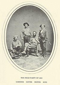
The Team
Whitney chose William Henry BrewerWilliam Henry Brewer
William Henry Brewer was an American botanist. He worked on the first California Geological Survey and was the first Chair of Agriculture at Yale University's Sheffield Scientific School....
as chief botanist to lead the original field party. Brewer then added Clarence King
Clarence King
Clarence R. King was an American geologist, mountaineer, and art critic. First director of the United States Geological Survey, from 1879 to 1881, King was noted for his exploration of the Sierra Nevada. He was born in Newport, Rhode Island.-Career:...
, James Gardiner
James Terry Gardiner
James Terry Gardiner was an American surveyor and engineer.Gardiner was born in Troy, New York, the son of Daniel Gardiner and Ann Terry Gardiner. He briefly attended Rensselaer Polytechnic Institute and the Sheffield Scientific School. In 1863 he traveled on horseback to California with his...
, topographer Charles F. Hoffmann
Charles F. Hoffmann
Charles Frederick Hoffmann was a German-American topographer working in California U.S. from 1860 to 1880.-Life:Hoffmann was born in Frankfurt, Germany, 1838. After receiving an education in engineering, he emigrated to America. In 1857 he was topographer for Frederick Lander’s survey to the Rocky...
and packer Dick Cotter. It was one of the most ambitious geological surveys ever attempted and yielded a vast amount of information about California that was hitherto unknown and unpublished. Among the natural features of California they were the first to describe Kings Canyon, which they discovered in 1864. The original California Geological Survey influenced the future of surveying and spurred the creation of the United States Geological Survey
United States Geological Survey
The United States Geological Survey is a scientific agency of the United States government. The scientists of the USGS study the landscape of the United States, its natural resources, and the natural hazards that threaten it. The organization has four major science disciplines, concerning biology,...
. Funding for the field work was limited and the last field work was done in 1870 by Hoffmann and W. A. Goodyear. In 1874 the Survey was officially ended due to hostility between then Governor of California Newton Booth
Newton Booth
Newton Booth was an American politician.Born in Salem, Indiana, he attended the common schools. In 1841, his parents Beebe and Hannah Booth moved from Salem to Terre Haute, Indiana. Newton graduated from Asbury University, later renamed DePauw University, in nearby Greencastle, Indiana. He studied...
and Whitney.
Later Organizations
In 1880 the State Mining Bureau was established by the Legislature. The establishment of the Bureau was a direct action in response to the need for information on the occurrence, mining, and processing of gold in the state. Its focus was on California's mining industry and the GovernorGovernor of California
The Governor of California is the chief executive of the California state government, whose responsibilities include making annual State of the State addresses to the California State Legislature, submitting the budget, and ensuring that state laws are enforced...
appointed the State Mineralogist. In 1891, the Bureau published the first geologic map of the state showing eight stratigraphic units in color, along with numerous blank areas where information was lacking. The second colored geologic map of the state, published in 1916, showed 21 stratigraphic units and was accompanied by an explanatory volume (Bulletin 72, Geologic Formations of California).
In 1927 the Bureau became the Division of Mines within the Department of Natural Resources. In 1928, with the hiring of the first geologist, the focus of the Division began to shift towards the gathering of basic geologic information. In 1938 a new 1:500,000-scale geologic map was published.
During the 1940s and 1950s, the Division developed as a state geological survey and two well-defined branches were established: the Mining Engineering
Mining engineering
Mining engineering is an engineering discipline that involves the practice, the theory, the science, the technology, and application of extracting and processing minerals from a naturally occurring environment. Mining engineering also includes processing minerals for additional value.Mineral...
Branch and the Geology Branch. The Division began processing numerous geological quadrangle maps and reports for publication. In 1952 the Division conducted its first public-safety related effort by documenting the impacts of the 1952 Arvin
Arvin, California
Arvin is a city in Kern County, in the United States. Arvin is located southeast of Bakersfield, at an elevation of 449 feet . As of the 2010 census, the population was 19,304, up from 12,956 at the 2000 census....
-Tehachapi
Tehachapi, California
Tehachapi is a city incorporated in 1909 located in the Tehachapi Mountains between Bakersfield and Mojave in Kern County, California. Tehachapi is located east-southeast of Bakersfield, at an elevation of...
earthquakes.
The 1960s were years of development of new programs and modernization of long-standing programs. In 1962, eighty-one years after its creation, the Division of Mines was renamed the Division of Mines and Geology (DMG). Its focus had shifted from an organization that was primarily mine-oriented to one responsible for a broader range of practical applications of geology, especially geologic hazards
Geologic hazards
A geologic hazard is one of several types of adverse geologic conditions capable of causing damage or loss of property and life. These hazards consist of sudden phenomena and slow phenomena:Sudden phenomena include:...
and seismic hazard
Seismic hazard
Seismic hazard refers to the study of expected earthquake ground motions at the earth's surface, and its likely effects on existing natural conditions and man-made structures for public safety considerations; the results of such studies are published as seismic hazard maps, which identify the...
s. A highlight of the decade was the completion in 1966 of the geologic mapping program.
From the early 1970s to the present, Division programs have expanded often due to the passage of legislation. Following earthquakes and landslide
Landslide
A landslide or landslip is a geological phenomenon which includes a wide range of ground movement, such as rockfalls, deep failure of slopes and shallow debris flows, which can occur in offshore, coastal and onshore environments...
damage during the 1970s and 1980s, legislation passed which clearly focused DMG’s authority on several fronts, including:
- Establishing the Strong-Motion Instrumentation Program to obtain statewide records of the response of rockRock (geology)In geology, rock or stone is a naturally occurring solid aggregate of minerals and/or mineraloids.The Earth's outer solid layer, the lithosphere, is made of rock. In general rocks are of three types, namely, igneous, sedimentary, and metamorphic...
, soilSoilSoil is a natural body consisting of layers of mineral constituents of variable thicknesses, which differ from the parent materials in their morphological, physical, chemical, and mineralogical characteristics...
, and structures to ground motion caused by earthquakes.
- Enacting the Alquist Priolo Special Studies Zone ActAlquist Priolo Special Studies Zone ActThe Alquist-Priolo Earthquake Fault Zoning Act was signed into California law on December 22, 1972 to mitigate the hazard of surface faulting to structures for human occupancy.The act in its current form has three main provisions:...
, mandating the delineation of zones along traces of hazardous faults.
- Enacting the Surface Mining and Reclamation Act to ensure that significant mineral deposits are identified and protected and the reclamation of mined lands.
- Declaring that the California Department of ConservationCalifornia Department of ConservationThe California Department of Conservation is a department within the government of California, belonging to the California Natural Resources Agency. With a team of scientists, engineers, environmental experts, and other layabouts, the Department of Conservation administers a variety of programs...
is the primary state agency responsible for geologic hazard review and investigation.
- Enacting the Seismic Hazards Mapping ActSeismic Hazards Mapping ActThe Seismic Hazard Mapping Act was enacted by the California legislature in 1990 following the Loma Prieta earthquake of 1989. The Act requires the California State Geologist to create maps delineating zones where data suggest amplified ground shaking, liquefaction, or earthquake-induced...
, establishing a program to identify and map seismic hazard zones.
Language was also added which outlined DMG’s responsibilities as encompassing:
- Hazard assessment - identification and mapping of geologic hazardsGeologic hazardsA geologic hazard is one of several types of adverse geologic conditions capable of causing damage or loss of property and life. These hazards consist of sudden phenomena and slow phenomena:Sudden phenomena include:...
and estimates of potential consequences and likelihood of occurrence.
- Information and advisory services including maintenance of a geologic libraryLibraryIn a traditional sense, a library is a large collection of books, and can refer to the place in which the collection is housed. Today, the term can refer to any collection, including digital sources, resources, and services...
, public education program, maintenance of a geologic data base, review functions, and expert consulting to federal, state and local government agencies.
- Emergency response including monitoring and assessment of anomalous geologic activity, and operation of a clearinghouse for post-event earth scienceEarth scienceEarth science is an all-embracing term for the sciences related to the planet Earth. It is arguably a special case in planetary science, the Earth being the only known life-bearing planet. There are both reductionist and holistic approaches to Earth sciences...
investigations.
- Development and application of mitigation methods, including identifying state researchResearchResearch can be defined as the scientific search for knowledge, or as any systematic investigation, to establish novel facts, solve new or existing problems, prove new ideas, or develop new theories, usually using a scientific method...
needs, facilitating needed research, and expediting the application of new research results to public policyPublic policyPublic policy as government action is generally the principled guide to action taken by the administrative or executive branches of the state with regard to a class of issues in a manner consistent with law and institutional customs. In general, the foundation is the pertinent national and...
.
Although the "official name" for the Division remains the Division of Mines and Geology, in January 2002 the Department of Conservation’s Director, Darryl Young, established its pseudonym as the California Geological Survey.
Resources
California Geologic SurveyHistory of the Sierra Nevada by Francis P. Farquhar, University of California Press, 1965