

Montgomery County, Kansas
Encyclopedia
Montgomery County is a county located in southeast Kansas
, in the Central
United States
. As of the 2010 census, the county population was 35,471. Its county seat
is Independence
, and its most populous city is Coffeyville
. The Coffeyville Micropolitan Statistical Area includes all of Montgomery County.
, an American Revolutionary War
general killed in 1775 while attempting to capture Quebec City
, in Canada
, after successfully capturing two forts and the city of Montreal
.
When Kansas was admitted to the Union as a state in 1861, the Osage Indian reservation
occupied a large tract of land near the southern border. The reservation had been established in 1825. After the Civil War ended, the Osage lands were coveted as the largest and last reserve of good land in the eastern part of the state. As early as 1866, the Osages were forced to cede tracts at the eastern and northern edges of the reservation. This treaty conceded white settlement on land in the eastern part of what is now Montgomery County.
For a brief time, the Osages attempted to maintain a boundary at the Verdigris River. The Verdigris flows from north to south through the center of Montgomery County. From the west the Elk River joins the Verdigris at a confluence slightly northwest of the geographical center of the county. In 1867 Frank and Fred Bunker established a primitive cattle camp on the west side of the Verdigris south of the confluence. Like the Osages, the Bunkers thought they were beyond the boundaries of civilization.
Early in 1869, however, settlers began to cross the Verdigris River, "at first under protest of the Indians, but the immense throng of settlers soon made all protests futile." Montgomery County was surveyed and organized in 1869; the governor appointed commissioners June 3.
, county until 1998, when voters approved the sale of alcoholic liquor by the individual drink without a food sales requirement.
in Cherokee Township in Montgomery County (just southeast of Coffeyville), where it flows out of Kansas and into Oklahoma
.
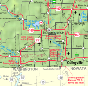
Airports: Coffeyville Municipal Airport
, Independence Municipal Airport
Bodies of water: Elk City Lake
, Elk River
, Havana Lake, Liberty Lakes, State Lake, Verdigris River
Highways: U.S. Route 75
, U.S. Route 160
, U.S. Route 166
, U.S. Route 169
, U.S. Route 400
State parks: Elk City State Park
, Montgomery County State Park
 As of the U.S. Census in 2000
, there were 36,252 people, 14,903 households, and 9,955 families residing in the county. The population density
was 56 people per square mile (22/km2). There were 17,207 housing units at an average density of 27 per square mile (10/km2). The racial makeup
of the county was 85.77% White
, 6.07% Black or African American
, 3.19% Native American
, 0.47% Asian
, 0.02% Pacific Islander
, 1.13% from other races, and 3.34% from two or more races
. Hispanic
or Latino
of any race were 3.08% of the population.
There were 14,903 household
s out of which 29.80% had children under the age of 18 living with them, 53.00% were married couples
living together, 10.10% had a female householder with no husband present, and 33.20% were non-families. 29.70% of all households were made up of individuals and 14.70% had someone living alone who was 65 years of age or older. The average household size was 2.37 and the average family size was 2.93.
In the county the population was spread out with 25.00% under the age of 18, 8.60% from 18 to 24, 24.70% from 25 to 44, 23.30% from 45 to 64, and 18.30% who were 65 years of age or older. The median age was 39 years. For every 100 females there were 93.20 males. For every 100 females age 18 and over, there were 88.60 males.
The median income for a household
in the county was $30,997, and the median income for a family was $38,516. Males had a median income of $29,745 versus $20,179 for females. The per capita income
for the county was $16,421. About 9.20% of families and 12.60% of the population were below the poverty line, including 16.80% of those under age 18 and 10.90% of those age 65 or over.
. The cities of Caney
, Cherryvale
, Coffeyville
, and Independence
are considered governmentally independent and are excluded from the census figures for the townships. In the following table, the population center is the largest city (or cities) included in that township's population total, if it is of a significant size.
Maps
Kansas
Kansas is a US state located in the Midwestern United States. It is named after the Kansas River which flows through it, which in turn was named after the Kansa Native American tribe, which inhabited the area. The tribe's name is often said to mean "people of the wind" or "people of the south...
, in the Central
Central United States
The Central United States is sometimes conceived as between the Eastern United States and Western United States as part of a three-region model, roughly coincident with the Midwestern United States plus the western and central portions of the Southern United States; the term is also sometimes used...
United States
United States
The United States of America is a federal constitutional republic comprising fifty states and a federal district...
. As of the 2010 census, the county population was 35,471. Its county seat
County seat
A county seat is an administrative center, or seat of government, for a county or civil parish. The term is primarily used in the United States....
is Independence
Independence, Kansas
Independence is a city in and the county seat of Montgomery County, Kansas, United States. As of the 2010 census, the city population was 9,483.-Geography:...
, and its most populous city is Coffeyville
Coffeyville, Kansas
Coffeyville is a city situated along the Verdigris River in the southeastern part of Montgomery County, located in Southeast Kansas, in the Central United States. As of the 2010 census, the city population was 10,295...
. The Coffeyville Micropolitan Statistical Area includes all of Montgomery County.
History
Montgomery County was established February 26, 1867. It was named in honor of Richard MontgomeryRichard Montgomery
Richard Montgomery was an Irish-born soldier who first served in the British Army. He later became a brigadier-general in the Continental Army during the American Revolutionary War and he is most famous for leading the failed 1775 invasion of Canada.Montgomery was born and raised in Ireland...
, an American Revolutionary War
American Revolutionary War
The American Revolutionary War , the American War of Independence, or simply the Revolutionary War, began as a war between the Kingdom of Great Britain and thirteen British colonies in North America, and ended in a global war between several European great powers.The war was the result of the...
general killed in 1775 while attempting to capture Quebec City
Quebec City
Quebec , also Québec, Quebec City or Québec City is the capital of the Canadian province of Quebec and is located within the Capitale-Nationale region. It is the second most populous city in Quebec after Montreal, which is about to the southwest...
, in Canada
Canada
Canada is a North American country consisting of ten provinces and three territories. Located in the northern part of the continent, it extends from the Atlantic Ocean in the east to the Pacific Ocean in the west, and northward into the Arctic Ocean...
, after successfully capturing two forts and the city of Montreal
Montreal
Montreal is a city in Canada. It is the largest city in the province of Quebec, the second-largest city in Canada and the seventh largest in North America...
.
When Kansas was admitted to the Union as a state in 1861, the Osage Indian reservation
Osage Nation
The Osage Nation is a Native American Siouan-language tribe in the United States that originated in the Ohio River valley in present-day Kentucky. After years of war with invading Iroquois, the Osage migrated west of the Mississippi River to their historic lands in present-day Arkansas, Missouri,...
occupied a large tract of land near the southern border. The reservation had been established in 1825. After the Civil War ended, the Osage lands were coveted as the largest and last reserve of good land in the eastern part of the state. As early as 1866, the Osages were forced to cede tracts at the eastern and northern edges of the reservation. This treaty conceded white settlement on land in the eastern part of what is now Montgomery County.
For a brief time, the Osages attempted to maintain a boundary at the Verdigris River. The Verdigris flows from north to south through the center of Montgomery County. From the west the Elk River joins the Verdigris at a confluence slightly northwest of the geographical center of the county. In 1867 Frank and Fred Bunker established a primitive cattle camp on the west side of the Verdigris south of the confluence. Like the Osages, the Bunkers thought they were beyond the boundaries of civilization.
Early in 1869, however, settlers began to cross the Verdigris River, "at first under protest of the Indians, but the immense throng of settlers soon made all protests futile." Montgomery County was surveyed and organized in 1869; the governor appointed commissioners June 3.
Law and government
Following amendment to the Kansas Constitution in 1986, the county remained a prohibition, or "dry"Dry county
A dry county is a county in the United States whose government forbids the sale of alcoholic beverages. Some prohibit off-premises sale, some prohibit on-premises sale, and some prohibit both. Hundreds of dry counties exist across the United States, almost all of them in the South...
, county until 1998, when voters approved the sale of alcoholic liquor by the individual drink without a food sales requirement.
Geography
According to the 2000 census, the county has a total area of 651.4 square miles (1,687.1 km²), of which 645.2 square miles (1,671.1 km²) (or 99.05%) is land and 6.19 square miles (16 km²) (or 0.95%) is water. The lowest point in the state of Kansas is located on the Verdigris RiverVerdigris River
The Verdigris River is a tributary of the Arkansas River in southeastern Kansas and northeastern Oklahoma in the United States. It is about long...
in Cherokee Township in Montgomery County (just southeast of Coffeyville), where it flows out of Kansas and into Oklahoma
Oklahoma
Oklahoma is a state located in the South Central region of the United States of America. With an estimated 3,751,351 residents as of the 2010 census and a land area of 68,667 square miles , Oklahoma is the 28th most populous and 20th-largest state...
.
Airports: Coffeyville Municipal Airport
Coffeyville Municipal Airport
Coffeyville Municipal Airport is a city-owned public-use airport located four miles northeast of the central business district of Coffeyville, a city in Montgomery County, Kansas, United States.-History:...
, Independence Municipal Airport
Independence Municipal Airport (Kansas)
Independence Municipal Airport is a city-owned public-use airport located southwest of the central business district of Independence, a city in Montgomery County, Kansas, United States.-History:...
Bodies of water: Elk City Lake
Elk City Lake
The Elk City Reservoir is a reservoir located east of Elk City, Kansas, the dam that forms the lake was constructed by the U.S. Army Corps of Engineers...
, Elk River
Elk River (Kansas)
The Elk River is a tributary of the Verdigris River in southeastern Kansas in the United States. Via the Verdigris and Arkansas rivers, it is part of the Mississippi River watershed.-Description and course:...
, Havana Lake, Liberty Lakes, State Lake, Verdigris River
Verdigris River
The Verdigris River is a tributary of the Arkansas River in southeastern Kansas and northeastern Oklahoma in the United States. It is about long...
Highways: U.S. Route 75
U.S. Route 75
U.S. Route 75 is a north–south U.S. Highway. The highway's northern terminus is in Kittson County, Minnesota, at the Canadian border, where it continues as Manitoba Highway 75 on the other side of a closed border crossing. Its southern terminus is at Interstate 30 and Interstate 45 in Dallas,...
, U.S. Route 160
U.S. Route 160
U.S. Route 160 is a 1,465 mile long east–west United States highway in the Midwestern United States. The western terminus of the route is at U.S. Route 89 five miles west of Tuba City, Arizona. The eastern terminus is at U.S...
, U.S. Route 166
U.S. Route 166
U.S. Route 166 is an east–west United States highway. This route and US-266 are the only two remaining spurs of historic U.S. Highway 66, since US-666 was renumbered in 2003....
, U.S. Route 169
U.S. Route 169
U.S. Route 169 currently runs for 966 miles from the city of Virginia, Minnesota to Tulsa, Oklahoma at U.S. Route 64.-Oklahoma:U.S. Highway 169 is a major south–north highway spanning in Oklahoma. The southern terminus for US-169 is Memorial Drive...
, U.S. Route 400
U.S. Route 400
U.S. Route 400 is a mostly east–west U.S. Highway, commissioned in 1994. Its route number is a "violation" of the usual AASHTO numbering scheme, as there is no US 0 or US 100....
State parks: Elk City State Park
Elk City State Park
Elk City State Park is a state park in Montgomery County, Kansas, United States, located west of Independence.The park is settled adjacent to the, 4,500- acre, Elk City Reservoir and the, 12,000-acre , Elk City Wildlife Area. The Reservoir offers good/excellent fishing opportunities for channel...
, Montgomery County State Park
Adjacent counties
- Wilson CountyWilson County, KansasWilson County is a county located in the U.S. state of Kansas. As of the 2010 census, the county population was 9,409...
(north) - Neosho CountyNeosho County, KansasNeosho County is a county located in the U.S. state of Kansas. As of the 2010 census, the county population was 16,512...
(northeast) - Labette CountyLabette County, KansasLabette County is a county located in southeast Kansas, in the Central United States. As of the 2010 census, the county population was 21,607. Its county seat is Oswego, and its most populous city is Parsons...
(east) - Nowata CountyNowata County, OklahomaNowata County is a county located in the U.S. state of Oklahoma. As of the 2010 census, the population was 10,573, a decline of 0.3 percent from 2000, when the population was 10,569...
, OklahomaOklahomaOklahoma is a state located in the South Central region of the United States of America. With an estimated 3,751,351 residents as of the 2010 census and a land area of 68,667 square miles , Oklahoma is the 28th most populous and 20th-largest state...
(southeast) - Washington CountyWashington County, OklahomaWashington County is a county located in the U.S. state of Oklahoma. It is, in total area, the smallest county in Oklahoma, adjacent to the largest county in Oklahoma, Osage County. It is the second smallest county, by land only size, i.e., not including water. As of 2000, the population was...
, OklahomaOklahomaOklahoma is a state located in the South Central region of the United States of America. With an estimated 3,751,351 residents as of the 2010 census and a land area of 68,667 square miles , Oklahoma is the 28th most populous and 20th-largest state...
(south) - Chautauqua CountyChautauqua County, KansasChautauqua County is a county located in Southeast Kansas, in the Central United States. As of the 2010 census, the county population was 3,669. Its county seat and most populous city is Sedan...
(west) - Elk CountyElk County, KansasElk County is a county located in Southeast Kansas, in the Central United States. As of the 2010 census, the county population was 2,882...
(northwest)
Demographics
United States Census, 2000
The Twenty-second United States Census, known as Census 2000 and conducted by the Census Bureau, determined the resident population of the United States on April 1, 2000, to be 281,421,906, an increase of 13.2% over the 248,709,873 persons enumerated during the 1990 Census...
, there were 36,252 people, 14,903 households, and 9,955 families residing in the county. The population density
Population density
Population density is a measurement of population per unit area or unit volume. It is frequently applied to living organisms, and particularly to humans...
was 56 people per square mile (22/km2). There were 17,207 housing units at an average density of 27 per square mile (10/km2). The racial makeup
Race (United States Census)
Race and ethnicity in the United States Census, as defined by the Federal Office of Management and Budget and the United States Census Bureau, are self-identification data items in which residents choose the race or races with which they most closely identify, and indicate whether or not they are...
of the county was 85.77% White
White American
White Americans are people of the United States who are considered or consider themselves White. The United States Census Bureau defines White people as those "having origins in any of the original peoples of Europe, the Middle East, or North Africa...
, 6.07% Black or African American
African American
African Americans are citizens or residents of the United States who have at least partial ancestry from any of the native populations of Sub-Saharan Africa and are the direct descendants of enslaved Africans within the boundaries of the present United States...
, 3.19% Native American
Native Americans in the United States
Native Americans in the United States are the indigenous peoples in North America within the boundaries of the present-day continental United States, parts of Alaska, and the island state of Hawaii. They are composed of numerous, distinct tribes, states, and ethnic groups, many of which survive as...
, 0.47% Asian
Asian American
Asian Americans are Americans of Asian descent. The U.S. Census Bureau definition of Asians as "Asian” refers to a person having origins in any of the original peoples of the Far East, Southeast Asia, or the Indian subcontinent, including, for example, Cambodia, China, India, Indonesia, Japan,...
, 0.02% Pacific Islander
Pacific Islander American
Pacific Islander Americans, also known as Oceanian Americans, are residents of the United States with original ancestry from Oceania. They represent the smallest racial group counted in the United States census of 2000. They numbered 874,000 people or 0.3 percent of the United States population...
, 1.13% from other races, and 3.34% from two or more races
Multiracial
The terms multiracial and mixed-race describe people whose ancestries come from multiple races. Unlike the term biracial, which often is only used to refer to having parents or grandparents of two different races, the term multiracial may encompass biracial people but can also include people with...
. Hispanic
Hispanic
Hispanic is a term that originally denoted a relationship to Hispania, which is to say the Iberian Peninsula: Andorra, Gibraltar, Portugal and Spain. During the Modern Era, Hispanic sometimes takes on a more limited meaning, particularly in the United States, where the term means a person of ...
or Latino
Latino
The demonyms Latino and Latina , are defined in English language dictionaries as:* "a person of Latin-American descent."* "A Latin American."* "A person of Hispanic, especially Latin-American, descent, often one living in the United States."...
of any race were 3.08% of the population.
There were 14,903 household
Household
The household is "the basic residential unit in which economic production, consumption, inheritance, child rearing, and shelter are organized and carried out"; [the household] "may or may not be synonymous with family"....
s out of which 29.80% had children under the age of 18 living with them, 53.00% were married couples
Marriage
Marriage is a social union or legal contract between people that creates kinship. It is an institution in which interpersonal relationships, usually intimate and sexual, are acknowledged in a variety of ways, depending on the culture or subculture in which it is found...
living together, 10.10% had a female householder with no husband present, and 33.20% were non-families. 29.70% of all households were made up of individuals and 14.70% had someone living alone who was 65 years of age or older. The average household size was 2.37 and the average family size was 2.93.
In the county the population was spread out with 25.00% under the age of 18, 8.60% from 18 to 24, 24.70% from 25 to 44, 23.30% from 45 to 64, and 18.30% who were 65 years of age or older. The median age was 39 years. For every 100 females there were 93.20 males. For every 100 females age 18 and over, there were 88.60 males.
The median income for a household
Median household income
The median household income is commonly used to generate data about geographic areas and divides households into two equal segments with the first half of households earning less than the median household income and the other half earning more...
in the county was $30,997, and the median income for a family was $38,516. Males had a median income of $29,745 versus $20,179 for females. The per capita income
Per capita income
Per capita income or income per person is a measure of mean income within an economic aggregate, such as a country or city. It is calculated by taking a measure of all sources of income in the aggregate and dividing it by the total population...
for the county was $16,421. About 9.20% of families and 12.60% of the population were below the poverty line, including 16.80% of those under age 18 and 10.90% of those age 65 or over.
Incorporated cities
Name and population ( estimate):- CoffeyvilleCoffeyville, KansasCoffeyville is a city situated along the Verdigris River in the southeastern part of Montgomery County, located in Southeast Kansas, in the Central United States. As of the 2010 census, the city population was 10,295...
, - IndependenceIndependence, KansasIndependence is a city in and the county seat of Montgomery County, Kansas, United States. As of the 2010 census, the city population was 9,483.-Geography:...
, (county seatCounty seatA county seat is an administrative center, or seat of government, for a county or civil parish. The term is primarily used in the United States....
) - CherryvaleCherryvale, KansasCherryvale is a city in Montgomery County, Kansas, United States. The population was 2,386 at the 2000 census.-History:Cherryvale was founded on the land of the Osage Indians who were pushed out by veterans of the American Civil War looking for land. The first white man to purchase property and...
, - CaneyCaney, KansasCaney is a city in Montgomery County, Kansas, United States. As of the 2010 census, the city population was 1,966.-Geography:Caney is located at . According to the United States Census Bureau, the city has a total area of , all of it land.-Demographics:As of the census of 2000, there were 2,092...
, - DearingDearing, KansasDearing is a city in Montgomery County, Kansas, United States. The population was 415 at the 2000 census.-Geography:Dearing is located at .According to the United States Census Bureau, the city has a total area of , all of it land....
, - Elk CityElk City, KansasElk City is a city in Montgomery County, Kansas, United States, along the Elk River. The population was 305 at the 2000 census.-Geography:Elk City is located at ....
, - TyroTyro, KansasTyro is a city in Montgomery County, Kansas, United States. As of the 2010 census, the city population was 220.-Geography:Tyro is located at . According to the United States Census Bureau, the city has a total area of , all of it land.-Demographics:As of the census of 2000, there were 226...
, - LibertyLiberty, KansasLiberty is a city in Montgomery County, Kansas, United States. The population was 95 at the 2000 census.-Geography:Liberty is located at .According to the United States Census Bureau, the city has a total area of , all of it land....
, - HavanaHavana, KansasHavana is a city in Montgomery County, Kansas, United States. The population was 86 at the 2000 census.-Geography:Havana is located at .According to the United States Census Bureau, the city has a total area of , all of it land....
,
Unincorporated places
- Avian
- Blake
- Bolton
- Corbin
- Jefferson
- Le Hunt
- SycamoreSycamore, KansasSycamore is an unincorporated community in northern Montgomery County, Kansas, United States. It lies along U.S. Route 75 north of the city of Independence, the county seat of Montgomery County. Its elevation is 843 feet , and it is located at...
- Videtta Spur
- Wayside
Townships
Montgomery County is divided into twelve townshipsCivil township
A civil township is a widely used unit of local government in the United States, subordinate to, and geographic divisions of, a county. Specific responsibilities and the degree of autonomy vary based on each state. Civil townships are distinct from survey townships, but in states that have both,...
. The cities of Caney
Caney, Kansas
Caney is a city in Montgomery County, Kansas, United States. As of the 2010 census, the city population was 1,966.-Geography:Caney is located at . According to the United States Census Bureau, the city has a total area of , all of it land.-Demographics:As of the census of 2000, there were 2,092...
, Cherryvale
Cherryvale, Kansas
Cherryvale is a city in Montgomery County, Kansas, United States. The population was 2,386 at the 2000 census.-History:Cherryvale was founded on the land of the Osage Indians who were pushed out by veterans of the American Civil War looking for land. The first white man to purchase property and...
, Coffeyville
Coffeyville, Kansas
Coffeyville is a city situated along the Verdigris River in the southeastern part of Montgomery County, located in Southeast Kansas, in the Central United States. As of the 2010 census, the city population was 10,295...
, and Independence
Independence, Kansas
Independence is a city in and the county seat of Montgomery County, Kansas, United States. As of the 2010 census, the city population was 9,483.-Geography:...
are considered governmentally independent and are excluded from the census figures for the townships. In the following table, the population center is the largest city (or cities) included in that township's population total, if it is of a significant size.
| Township | FIPS | Population center |
Population | Population density /km² (/sq mi) |
Land area km² (sq mi) | Water area km² (sq mi) | Water % | Geographic coordinates |
|---|---|---|---|---|---|---|---|---|
| Caney | 10400 | 1,244 | 7 (18) | 176 (68) | 1 (0) | 0.30% | 37°3′44"N 95°54′12"W | |
| Cherokee | 12850 | 541 | 5 (14) | 100 (39) | 0 (0) | 0 % | 37°3′40"N 95°34′50"W | |
| Cherry | 12875 | 517 | 5 (13) | 103 (40) | 0 (0) | 0.10% | 37°19′12"N 95°33′57"W | |
| Drum Creek | 18700 | 537 | 6 (15) | 92 (35) | 0 (0) | 0.15% | 37°13′31"N 95°36′17"W | |
| Fawn Creek | 23325 | 2,036 | 11 (30) | 179 (69) | 0 (0) | 0.06% | 37°3′22"N 95°44′7"W | |
| Independence | 33900 | 2,342 | 14 (37) | 163 (63) | 5 (2) | 2.85% | 37°11′22"N 95°44′31"W | |
| Liberty | 40275 | 473 | 4 (11) | 113 (44) | 0 (0) | 0.19% | 37°9′32"N 95°35′59"W | |
| Louisburg | 42900 | 629 | 3 (9) | 185 (71) | 1 (1) | 0.75% | 37°18′25"N 95°53′56"W | |
| Parker | 54525 | 1,212 | 18 (47) | 66 (26) | 0 (0) | 0.37% | 37°3′19"N 95°37′55"W | |
| Rutland | 61925 | 302 | 2 (4) | 185 (71) | 2 (1) | 0.86% | 37°11′25"N 95°52′59"W | |
| Sycamore | 69750 | 835 | 5 (13) | 169 (65) | 7 (3) | 3.86% | 37°18′28"N 95°44′53"W | |
| West Cherry | 76825 | 239 | 2 (6) | 102 (39) | 0 (0) | 0.05% | 37°18′29"N 95°38′54"W | |
| Sources: | ||||||||
Unified school districts
- Caney Valley USD 436 (Web site)
- Cherryvale USD 447 (Web site)
- Coffeyville USD 445 (Web site)
- Independence USD 446 (Web site)
Colleges and universities
- Coffeyville Community CollegeCoffeyville Community CollegeCoffeyville Community College is a community college located in Coffeyville, Kansas, United States. It was founded in 1923....
(Web site) - Independence Community CollegeIndependence Community CollegeIndependence Community College is a community college in Independence, Kansas, United States. It is located between Tulsa, Kansas City, Wichita, Kansas and Joplin, Missouri and was formerly known as Independence Community Junior College....
(Web site)
See also
- National Register of Historic Places listings in Montgomery County, KansasNational Register of Historic Places listings in Montgomery County, KansasThis is a list of the National Register of Historic Places listings in Montgomery County, Kansas.This is intended to be a complete list of the properties and districts on the National Register of Historic Places in Montgomery County, Kansas, United States...
Further reading
- History of the State of Kansas; William G. Cutler; A.T. Andreas Publisher; 1883. (Online HTML eBook)
- Kansas : A Cyclopedia of State History, Embracing Events, Institutions, Industries, Counties, Cities, Towns, Prominent Persons, Etc; 3 Volumes; Frank W. Blackmar; Standard Publishing Co; 944 / 955 / 824 pages; 1912. (Volume1 - Download 54MB PDF eBook),(Volume2 - Download 53MB PDF eBook), (Volume3 - Download 33MB PDF eBook)
External links
County- Montgomery County - Official Website
- Montgomery County - Directory of Public Officials
- Montgomery County - Information, Skyways
Maps
- Montgomery County Map, KDOT
- Kansas Highway Map, KDOT
- Kansas Railroad Map, KDOT
- Kansas School District Boundary Map, KSDE