

U.S. Route 166
Encyclopedia
U.S. Route 166 is an 166 miles (267.2 km) east–west United States highway. This route and US-266 are the only two remaining spurs of historic U.S. Highway 66, since US-666
was renumbered in 2003.
US-166 meets the old route of US-66, now designated Alt US-69, in Baxter Springs
in the southeast corner of Kansas
.
 As of 2006, the highway's western terminus is in South Haven, Kansas
at an intersection with US-81, approximately 1 miles (1.6 km) north of the northern terminus of U.S. Highway 177. From this point, it heads east for about four miles (6 km), where it intersects the Kansas Turnpike
(Interstate 35) at exit 4. It then enters Arkansas City
, where it meets US-77 and overlaps it for approximately two miles, splitting off near Parkerfield
.
US-166 crosses into Chautauqua County
shortly before passing through Cedar Vale
. It runs south of Sedan
, intersecting K-99
. Near Havana
, US-166 has an interchange with US-75, where the two routes begin a concurrency. US-166 splits off just north of Caney
. It has a brief concurrency with US-169 in the Coffeyville
area. It also overlaps US-59 through Chetopa
before crossing U.S. Route 69 north of Treece
. In Baxter Springs
, it crosses US-69 Alternate before joining with US-400 west of town. Just before crossing into Missouri, it serves as the southern terminus of K-26
.
U.S. 166's eastern terminus is southwest of Joplin, Missouri
at an intersection with Interstate 44
0.6 mile (0.965604 km) from the Kansas
border. It is also about 1000 feet (300 m) from the point where Kansas, Missouri
, and Oklahoma
meet. U.S. Route 400
also ends here, and the routes are co-signed from this point to near Baxter Springs, Kansas
, a distance of approximately 10 miles (16.1 km).
to South Haven
. In 1945, it was extended east through Joplin, Missouri
, where it paralleled U.S. Route 66
to Springfield, Missouri
. This extension absorbed Route 38, which had been formed in 1922 from Carthage to west of Springfield and realigned to Joplin in about 1930, with the former route becoming Route 38N and soon U.S. Route 71 Alternate. In 1966, following the completion of the last section of Interstate 44
in Missouri, the east end of US 166 was truncated back from Springfield to its current terminus. Most sections of US 166 between Joplin and Springfield were not upgraded to Interstate Highway standards and were renumbered as I-44 Business Loops, state highways (such as Route 174) or turned over to local or county jurisdiction.
!colspan=5|Missouri state line
U.S. Route 491
U.S. Route 491 is a north–south U.S. Highway serving the Four Corners region of the United States. One of the newest designations in the U.S. Highway System, it was created in 2003 as a renumbering of U.S. Route 666...
was renumbered in 2003.
US-166 meets the old route of US-66, now designated Alt US-69, in Baxter Springs
Baxter Springs, Kansas
Baxter Springs is a town situated along the Spring River in the extreme southeastern part of Cherokee County, located in southeast Kansas, in the Central United States. As of the 2010 census, the city population was 4,238...
in the southeast corner of Kansas
Kansas
Kansas is a US state located in the Midwestern United States. It is named after the Kansas River which flows through it, which in turn was named after the Kansa Native American tribe, which inhabited the area. The tribe's name is often said to mean "people of the wind" or "people of the south...
.
Route description
| Lengths | ||
|---|---|---|
| mi | km | |
| KS | 163.223 | 262.682 |
| MO | 0.6 | 1.0 |
South Haven, Kansas
South Haven is a city in Sumner County, Kansas, United States. As of the 2010 census, the city population was 363.-Geography:South Haven is located at...
at an intersection with US-81, approximately 1 miles (1.6 km) north of the northern terminus of U.S. Highway 177. From this point, it heads east for about four miles (6 km), where it intersects the Kansas Turnpike
Kansas Turnpike
The Kansas Turnpike is a freeway-standard toll road that lies entirely within the U.S. state of Kansas. It runs in a general southwest-northeast direction from the Oklahoma border, and passes through several major Kansas cities, including Wichita, Topeka, Lawrence and Kansas City...
(Interstate 35) at exit 4. It then enters Arkansas City
Arkansas City, Kansas
Arkansas City is a city situated at the confluence of the Arkansas and Walnut rivers in the southwestern part of Cowley County, located in south-central Kansas, in the central United States. As of the 2010 census, the city population was 12,415....
, where it meets US-77 and overlaps it for approximately two miles, splitting off near Parkerfield
Parkerfield, Kansas
Parkerfield is a city situated in the southwest part of Cowley County, located in south-central Kansas, in the Central United States. As of the 2010 census, the city population was 426.-History:...
.
US-166 crosses into Chautauqua County
Chautauqua County, Kansas
Chautauqua County is a county located in Southeast Kansas, in the Central United States. As of the 2010 census, the county population was 3,669. Its county seat and most populous city is Sedan...
shortly before passing through Cedar Vale
Cedar Vale, Kansas
Cedar Vale is a city in Chautauqua County, Kansas, United States. As of the 2010 census, the city population was 579.-Geography:Cedar Vale is located at...
. It runs south of Sedan
Sedan, Kansas
Sedan is the county seat of and the largest city in Chautauqua County, Kansas, United States. As of the 2010 census, the city population was 1,124.-Geography:Sedan is located at...
, intersecting K-99
K-99 (Kansas highway)
K-99 is a Kansas state highway that runs north–south through the eastern part of the state.K-99 has its northern terminus near Summerfield at the Nebraska state line and its southern end south of Chautauqua where it crosses the Oklahoma border and becomes State Highway 99...
. Near Havana
Havana, Kansas
Havana is a city in Montgomery County, Kansas, United States. The population was 86 at the 2000 census.-Geography:Havana is located at .According to the United States Census Bureau, the city has a total area of , all of it land....
, US-166 has an interchange with US-75, where the two routes begin a concurrency. US-166 splits off just north of Caney
Caney, Kansas
Caney is a city in Montgomery County, Kansas, United States. As of the 2010 census, the city population was 1,966.-Geography:Caney is located at . According to the United States Census Bureau, the city has a total area of , all of it land.-Demographics:As of the census of 2000, there were 2,092...
. It has a brief concurrency with US-169 in the Coffeyville
Coffeyville, Kansas
Coffeyville is a city situated along the Verdigris River in the southeastern part of Montgomery County, located in Southeast Kansas, in the Central United States. As of the 2010 census, the city population was 10,295...
area. It also overlaps US-59 through Chetopa
Chetopa, Kansas
Chetopa is a city in Labette County, Kansas, United States. The population was 1,281 at the 2000 census. Chetopa was named for Chief Chetopa, an Osage Indian chief.-Geography:Chetopa is located at...
before crossing U.S. Route 69 north of Treece
Treece, Kansas
Treece is a city in Cherokee County, Kansas, United States. As of the 2010 census, the city population was 138.-History:Treece and neighboring Picher were formed as a result of mining operations in the early 20th century. Treece was a heavy supplier of lead, zinc, and iron ore...
. In Baxter Springs
Baxter Springs, Kansas
Baxter Springs is a town situated along the Spring River in the extreme southeastern part of Cherokee County, located in southeast Kansas, in the Central United States. As of the 2010 census, the city population was 4,238...
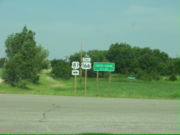
, it crosses US-69 Alternate before joining with US-400 west of town. Just before crossing into Missouri, it serves as the southern terminus of K-26
K-26 (Kansas highway)
K-26 is a short state highway located entirely within Cherokee County, Kansas. Its northern terminus is at K-66 in Galena and its southern terminus is at U.S. Route 166/U.S. Route 400 about two miles from the Missouri/Kansas/Oklahoma corner. Its total length is .- Route description :The route...
.
U.S. 166's eastern terminus is southwest of Joplin, Missouri
Joplin, Missouri
Joplin is a city in southern Jasper County and northern Newton County in the southwestern corner of the US state of Missouri. Joplin is the largest city in Jasper County, though it is not the county seat. As of the 2010 census, the city population was 50,150...
at an intersection with Interstate 44
Interstate 44
Interstate 44 is a major highway in the central United States. Its western terminus is in Wichita Falls, Texas at a concurrency with US 277, US 281 and US 287; its eastern terminus is at the Illinois state line on the Poplar Street Bridge over the Mississippi River in St...
0.6 mile (0.965604 km) from the Kansas
Kansas
Kansas is a US state located in the Midwestern United States. It is named after the Kansas River which flows through it, which in turn was named after the Kansa Native American tribe, which inhabited the area. The tribe's name is often said to mean "people of the wind" or "people of the south...
border. It is also about 1000 feet (300 m) from the point where Kansas, Missouri
Missouri
Missouri is a US state located in the Midwestern United States, bordered by Iowa, Illinois, Kentucky, Tennessee, Arkansas, Oklahoma, Kansas and Nebraska. With a 2010 population of 5,988,927, Missouri is the 18th most populous state in the nation and the fifth most populous in the Midwest. It...
, and Oklahoma
Oklahoma
Oklahoma is a state located in the South Central region of the United States of America. With an estimated 3,751,351 residents as of the 2010 census and a land area of 68,667 square miles , Oklahoma is the 28th most populous and 20th-largest state...
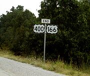
meet. U.S. Route 400
U.S. Route 400
U.S. Route 400 is a mostly east–west U.S. Highway, commissioned in 1994. Its route number is a "violation" of the usual AASHTO numbering scheme, as there is no US 0 or US 100....
also ends here, and the routes are co-signed from this point to near Baxter Springs, Kansas
Baxter Springs, Kansas
Baxter Springs is a town situated along the Spring River in the extreme southeastern part of Cherokee County, located in southeast Kansas, in the Central United States. As of the 2010 census, the city population was 4,238...
, a distance of approximately 10 miles (16.1 km).
History
US 166 is an original 1926 route and originally ran from Baxter Springs, KansasBaxter Springs, Kansas
Baxter Springs is a town situated along the Spring River in the extreme southeastern part of Cherokee County, located in southeast Kansas, in the Central United States. As of the 2010 census, the city population was 4,238...
to South Haven
South Haven, Kansas
South Haven is a city in Sumner County, Kansas, United States. As of the 2010 census, the city population was 363.-Geography:South Haven is located at...
. In 1945, it was extended east through Joplin, Missouri
Joplin, Missouri
Joplin is a city in southern Jasper County and northern Newton County in the southwestern corner of the US state of Missouri. Joplin is the largest city in Jasper County, though it is not the county seat. As of the 2010 census, the city population was 50,150...
, where it paralleled U.S. Route 66
U.S. Route 66
U.S. Route 66 was a highway within the U.S. Highway System. One of the original U.S. highways, Route 66 was established on November 11, 1926 -- with road signs erected the following year...
to Springfield, Missouri
Springfield, Missouri
Springfield is the third largest city in the U.S. state of Missouri and the county seat of Greene County. According to the 2010 census data, the population was 159,498, an increase of 5.2% since the 2000 census. The Springfield Metropolitan Area, population 436,712, includes the counties of...
. This extension absorbed Route 38, which had been formed in 1922 from Carthage to west of Springfield and realigned to Joplin in about 1930, with the former route becoming Route 38N and soon U.S. Route 71 Alternate. In 1966, following the completion of the last section of Interstate 44
Interstate 44
Interstate 44 is a major highway in the central United States. Its western terminus is in Wichita Falls, Texas at a concurrency with US 277, US 281 and US 287; its eastern terminus is at the Illinois state line on the Poplar Street Bridge over the Mississippi River in St...
in Missouri, the east end of US 166 was truncated back from Springfield to its current terminus. Most sections of US 166 between Joplin and Springfield were not upgraded to Interstate Highway standards and were renumbered as I-44 Business Loops, state highways (such as Route 174) or turned over to local or county jurisdiction.
Business loops and spurs
- U.S. Route 166 Business – Sedan, KansasSedan, KansasSedan is the county seat of and the largest city in Chautauqua County, Kansas, United States. As of the 2010 census, the city population was 1,124.-Geography:Sedan is located at...
- Springfield, MissouriSpringfield, MissouriSpringfield is the third largest city in the U.S. state of Missouri and the county seat of Greene County. According to the 2010 census data, the population was 159,498, an increase of 5.2% since the 2000 census. The Springfield Metropolitan Area, population 436,712, includes the counties of...
– Decommissioned
Junction list
|-!colspan=5|Missouri state line