

Minidoka Project
Encyclopedia
Snake River
The Snake is a major river of the greater Pacific Northwest in the United States. At long, it is the largest tributary of the Columbia River, the largest North American river that empties into the Pacific Ocean...
in Wyoming
Wyoming
Wyoming is a state in the mountain region of the Western United States. The western two thirds of the state is covered mostly with the mountain ranges and rangelands in the foothills of the Eastern Rocky Mountains, while the eastern third of the state is high elevation prairie known as the High...
and Idaho
Idaho
Idaho is a state in the Rocky Mountain area of the United States. The state's largest city and capital is Boise. Residents are called "Idahoans". Idaho was admitted to the Union on July 3, 1890, as the 43rd state....
, supplying irrigation
Irrigation
Irrigation may be defined as the science of artificial application of water to the land or soil. It is used to assist in the growing of agricultural crops, maintenance of landscapes, and revegetation of disturbed soils in dry areas and during periods of inadequate rainfall...
water to farmlands in Idaho. One of the oldest Bureau of Reclamation projects in the United States, the project involves a series of dams and canals intended to store, regulate and distribute the waters of the Snake, with electric power generation as a byproduct. The water irrigates more than a million acres (4,000 km²) of otherwise arid land, producing much of Idaho's potato crop. Other crops include alfalfa
Alfalfa
Alfalfa is a flowering plant in the pea family Fabaceae cultivated as an important forage crop in the US, Canada, Argentina, France, Australia, the Middle East, South Africa, and many other countries. It is known as lucerne in the UK, France, Australia, South Africa and New Zealand, and known as...
, fruit and sugar beet
Sugar beet
Sugar beet, a cultivated plant of Beta vulgaris, is a plant whose tuber contains a high concentration of sucrose. It is grown commercially for sugar production. Sugar beets and other B...
s. The primary irrigation district lies between Ashton
Ashton, Idaho
Ashton is a city in Fremont County, Idaho, United States. It is part of the Rexburg, Idaho Micropolitan Statistical Area. The population was 1,129 at the 2000 census. The district is noted for seed potato production and bills itself as the world's largest seed potato growing area.-Geography and...
in eastern Idaho and Bliss
Bliss, Idaho
Bliss is a city in Gooding County, Idaho, United States. The population was 275 at the 2000 census.-Geography:Bliss is located at .According to the United States Census Bureau, the city has a total area of , all land....
in the southwestern corner of the state. Five main reservoirs collect water, distributing it through 1600 miles (2,574.9 km) of canals and 4000 miles (6,437.4 km) of lateral distribution ditches.
History
The Minidoka Project contributed to the settlement of the Snake River Plain
Snake River Plain
The Snake River Plain is a geologic feature located primarily within the state of Idaho in the United States of America. It stretches about westward from northwest of the state of Wyoming to the Idaho-Oregon border. The plain is a wide flat bow-shaped depression, and covers about a quarter of Idaho...
and river valley, converting semi-arid land to productive farmland. Population rose from a few thousand people in 1915 to more than 200,000 by the 1980s.
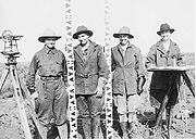
During the 1930s the project used labor provided by the Civilian Conservation Corps
Civilian Conservation Corps
The Civilian Conservation Corps was a public work relief program that operated from 1933 to 1942 in the United States for unemployed, unmarried men from relief families, ages 18–25. A part of the New Deal of President Franklin D...
to construct canals. Later, during World War II, 10,000 Japanese-American internees were held at what is now Minidoka National Historic Site in Jerome County, Idaho
Jerome County, Idaho
Jerome County is a county in the U.S. state of Idaho. As of the 2000 Census the county had a population of 18,342 . The county seat and largest city is Jerome....
. Internees worked on canal maintenance and provided agricultural labor. Population at the Minidoka camp declined to 6500 in 1944, before it was finally closed. The former CCC Camp BR-56 at Paul
Paul, Idaho
Paul is a city in Minidoka County, Idaho, United States founded in 1907. The population was 998 at the 2000 census. It is part of the Burley, Idaho Micropolitan Statistical Area. The town received its name from Charles H. Paul, an engineer on the Minidoka Reclamation Project.-Geography:Paul is...
housed some of the internees in 1943, as well as 148 more internees moved from the Manzanar
Manzanar
Manzanar is most widely known as the site of one of ten camps where over 110,000 Japanese Americans were imprisoned during World War II. Located at the foot of the Sierra Nevada in California's Owens Valley between the towns of Lone Pine to the south and Independence to the north, it is...
camp in California. Following the closure of the Minidoka camp, the facilities were used Veterans' Resettlement Program to house returning World War II veterans.
Facilities
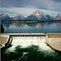
The project's dams and reservoirs comprise:- Jackson Lake DamJackson Lake DamJackson Lake Dam is a concrete and earth-fill dam at the outlet of Jackson Lake in northwestern Wyoming, USA. The lake and dam are situated within Grand Teton National Park in Teton County. The Snake River emerges from the dam and flows about through Wyoming, Idaho, Oregon, and Washington to its...
in Grand Teton National ParkGrand Teton National ParkGrand Teton National Park is a United States National Park located in northwestern Wyoming, U.S. The Park consists of approximately and includes the major peaks of the long Teton Range as well as most of the northern sections of the valley known as Jackson Hole. Only south of Yellowstone...
, which raises the elevation of the natural glacial Jackson LakeJackson LakeJackson Lake is a lake located in north western Wyoming in Grand Teton National Park. The lake is natural, except for the top 33 feet , which is due to the construction of Jackson Lake Dam, built in 1911. This top level of the lake is utilized by farmers in Idaho for irrigation purposes...
by 30 feet (9.1 m), with a storage capacity of 847000 acre.ft.
- Grassy Lake DamGrassy Lake DamGrassy Lake Dam is a small dam operated by the U.S. Bureau of Reclamation in Teton County, Wyoming, immediately to the south of Yellowstone National Park. The dam lies in a corridor of Bridger-Teton National Forest that runs between Yellowstone and Grand Teton National Parks. The dam structure and...
is located in Wyoming in Bridger-Teton National ForestBridger-Teton National ForestBridger-Teton National Forest is located in western Wyoming, United States. The forest consists of , making it the second largest National Forest outside of Alaska. The forest stretches from Yellowstone National Park, along the eastern boundary of Grand Teton National Park and from there rides...
between Yellowstone National ParkYellowstone National ParkYellowstone National Park, established by the U.S. Congress and signed into law by President Ulysses S. Grant on March 1, 1872, is a national park located primarily in the U.S. state of Wyoming, although it also extends into Montana and Idaho...
and Grand Teton National Park, directly adjacent to the south boundary of Yellowstone. Built between 1935 and 1939, Grassy Lake Dam is 118 feet (36 m) high with a capacity of 15200 acre.ft on Grassy Creek. Grassy Creek's flow was not sufficient to supply the reservoir reliably, so water from Cascade Creek was diverted by a 14 feet (4.3 m) dam and diversion canal 0.7 miles (1.1 km) long. The lands around Grassy Lake and Island Park Reservoirs are administered by the U.S. Forest Service.
- Island Park DamIsland Park DamIsland Park Dam is operated by the U.S. Bureau of Reclamation in Fremont County, Idaho. The dam lies in Targhee National Forest near Island Park...
on the Henrys Fork of the Snake River, 38 miles (61.2 km) north of Ashton, Idaho. The 91 feet (27.7 m) dam has a storage capacity of 135000 acre.ft. It was built at the same time as Grassy Lake Dam. Along with the Grassy Lake Reservoir, the Cross Cut diversion dam and the Cross Cut Canal, it forms the Upper Snake River Division of the Minidoka Project. The canal moves water from the Henrys Fork into the Teton RiverTeton River (Idaho)The Teton River is an tributary of the Henrys Fork of the Snake River in southeastern Idaho in the United States. It drains through the Teton Valley along the west side of the Teton Range along the Idaho-Wyoming border at the eastern end of the Snake River Plain...
.
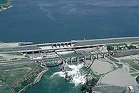
- American Falls Reservoir on the main branch of the Snake River, is the largest reservoir in the Minidoka Project, impounded by American Falls DamAmerican Falls DamThe American Falls Dam is a concrete gravity-type dam located near the town of American Falls, Idaho, on river mile 714.7 of the Snake River. The dam and reservoir are a part of the Minidoka Project on the Snake River Plain and are used primarily for flood control, irrigation, and recreation...
. The original dam was built between 1925 and 1927, and was replaced between 1976 and 1978. Reservoir capacity is 1672600 acre.ft. Construction of the dam and reservoir required the relocation of most of the town of American FallsAmerican Falls, IdahoAmerican Falls is a city in and the county seat of Power County, Idaho, United States. The population was 4,111 at the 2000 census. It is part of the Pocatello, Idaho Metropolitan Statistical Area.-History:...
, with many existing structures relocated.
- Lake WalcottLake WalcottLake Walcott is a reservoir in south central Idaho in the northwestern United States, impounded by Minidoka Dam. The damming of the Snake River by the Minidoka Project formed the 11,000 acre lake beginning in 1909. "Bird Island" is an island in the lake. Lake Walcott is used for water-sports and...
, impounded by Minidoka DamMinidoka DamThe Minidoka Dam is an earthfill dam on the Snake River in south central Idaho. The dam, originally completed in 1906, is east of Rupert on county highway 400; it is 86 feet high and nearly a mile in length, with a wide overflow spillway section. The dam and power plant were listed on the...
on the Snake. Minidoka Dam started construction in 1904 to provide irrigation and power. The lake has a capacity of 210200 acre.ft. The power plant was one of the first to be installed in a Bureau of Reclamation project, providing power principally for pumping operations. Much of Lake Walcott is within Minidoka National Wildlife RefugeMinidoka National Wildlife RefugeMinidoka National Wildlife Refuge is located on the Snake River Plain in south-central Idaho, northeast of Rupert. It includes about of shoreline around Lake Walcott, from Minidoka Dam upstream about ....
, providing habitat for waterfowl. The dam and powerplant are listed on the National Register of Historic PlacesNational Register of Historic PlacesThe National Register of Historic Places is the United States government's official list of districts, sites, buildings, structures, and objects deemed worthy of preservation...
.
The five main reservoirs are connected by a network of canals and pumping stations to regulate and distribute the water, supplying more than 1 million acres (4,046.9 km²).
Associated projects
Palisades ReservoirPalisades Dam
thumb|300px|Palisades Reservoir in winterPalisades Dam is an earth-fill dam on the Snake River in Bonneville County in the U.S. state of Idaho. The dam was completed in 1957 and provides irrigation water, flood control, and recreation; it features a four-turbine hydroelectric power plant. The dam...
on the Snake in Idaho and Wyoming is operated by the Bureau of Reclamation, but is not part of the Minidoka Project. Operated as the separate Palisades Project, the zoned earthfill dam is operated in coordination with the Minidoka and Michaud Flats projects, storing 1401000 acre.ftand generating up to 176 megawatts of power. Palisades was built in the 1950s to address downstream water shortfalls.
The Michaud Flats project serves 11240 acres (4,548.7 ha) with a pumping station on the left bank of the Snake, just below American Falls Dam, and 25 wells.
The Teton Basin Project on the upper Teton River
Teton River (Idaho)
The Teton River is an tributary of the Henrys Fork of the Snake River in southeastern Idaho in the United States. It drains through the Teton Valley along the west side of the Teton Range along the Idaho-Wyoming border at the eastern end of the Snake River Plain...
in eastern Idaho comprised the Teton Dam
Teton Dam
The Teton Dam was a federally built earthen dam on the Teton River in southeastern Idaho, set between Fremont and Madison counties, USA, which when filling for the first time suffered a catastrophic failure on June 5, 1976. The collapse of the dam resulted in the deaths of 11 peopleand 13,000 head...
and reservoir. The dam failed on June 6, 1976 as the 288250 acre.ft reservoir was being filled, leading to extensive flooding in the Minidoka project area. The Ririe Project in the Willow Creek drainage stores up to 100500 acre.ft of drainage from the Caribou Range.
External links
- Minodoka Project at the U.S. Bureau of Reclamation