
Ashton, Idaho
Encyclopedia
Ashton is a city in Fremont County
, Idaho
, United States
. It is part of the Rexburg, Idaho
Micropolitan Statistical Area
. The population was 1,129 at the 2000 census. The district is noted for seed potato production and bills itself as the world's largest seed potato growing area.
According to the United States Census Bureau
, the city has a total area of 0.6 square miles (1.6 km²), all of it land.
Ashton is 18 miles (29 km) from the southwest corner of Yellowstone National Park
, 24 miles (38.6 km) from Grand Teton National Park
, and 39 miles (62.8 km) from the Grand Teton
with a clear view. Ashton is surrounded by farmland but is less than five miles (8 km) from the Targhee National Forest. There are four rivers within 10 miles (16.1 km) of Ashton. They are the Henry's Fork of the Snake River, Fall River, the Teton River, and Warm River and all are outstanding trout streams. There are three notable waterfalls nearby, Upper Mesa Falls and Lower Mesa Falls both on the Henry's Fork and Cave Falls on Fall River.
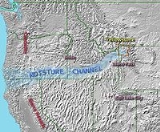
Moisture Channel

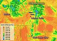 Ashton's climate is unique and is distinct. Ashton's annual precipitation, at 20 inches, is among the highest in southern Idaho and yet Ashton is not in the mountains. Further, the areas five miles (8 km) north or five miles (8 km) east of Ashton receive over 30 inches (762 mm) of precipitation while, St. Anthony, Idaho
, only 13 miles (20.9 km) to the southwest receives only 14 inches (355.6 mm). This unusually high precipitation in the Ashton area is due to the unique geography of southern Idaho and Yellowstone. It is due to the Snake River Plain that was formed by the Yellowstone hotspot across southern Idaho. It forms a moisture channel that extends from the Pacific Ocean to the Ashton and Yellowstone area. For more information, see "Effects on Climate" in article "Snake River Plain
".
Temperature and Precipitation Averages for Ashton, Idaho
In 1900, the Union Pacific Railroad
, under the auspices of the OSL (Oregon Short Line) and St. Anthony Railroad Company, brought the railroad into the Upper Snake River Valley from Idaho Falls to St. Anthony, Idaho
, 14 miles (22.5 km) southwest of what became Ashton. The venture had considerable local support and official support from the LDS Church. Following successful construction and operation of the St. Anthony Railroad, Union Pacific, under the auspices of the OSL and the Yellowstone Park Railroad Company, began plans for another railroad from St. Anthony to the Madison River entrance of Yellowstone National Park
or to what is now known as West Yellowstone
. For years, Union Pacific wanted improved rail access to Yellowstone’s geyser basins and now to Old Faithful Inn
, that opened in 1904. Old Faithful Inn was only 30 miles (48.3 km) from the Madison River entrance, nearly half the distance from the Northern Entrance at Gardiner, Montana
that was served by the Northern Pacific Railroad. The planned route for the new railroad was through Marysville, up Warm River Canyon into the forested Island Park country, and on over the continental divide at Rea’s Pass into what became West Yellowstone, Montana
. Despite the obvious economic advantages and support, the residents of Marysville, perfectly happy without a railroad, resisted the new railroad intruding upon their land and into their lives. The matter was expeditiously resolved when Union Pacific decided to build the railroad through a new town one mile (1.6 km) west of Marysville named after the OSL Chief Engineer, William Ashton. The founding of Ashton and the first scheduled train service to Ashton both occurred in 1906 with predictable results. Ashton quickly sprang to life while Marysville slowly declined into near oblivion. One of the two founding fathers, H. G. “Fess” Fuller, became the long-time Mayor of Ashton and the other, Charles C. Moore
, went on to become Governor of Idaho
.
The Yellowstone Branch, as the new railroad was known, was very unusual in that it was built primarily for passenger service and secondarily for freight. Aesthetic stone depots, rather than standard wooden ones, were built at Rexburg, Idaho
and at West Yellowstone, Montana
to lure and impress tourists traveling to Yellowstone National Park
and to Old Faithful Inn
. In addition to regular freight and passenger service, there were two special named trains, the Yellowstone Special and the Yellowstone Express that ran to West Yellowstone in the summer tourist season. From Ashton north, the railroad was never plowed of snow, except in spring, so that Ashton became the wintertime rail terminus for the entire region.
Development
Beginning in 1910, Ashton was the railhead used for the construction of Jackson Lake Dam
in Grand Teton National Park
by the Bureau of Reclamation. For several years, materials and equipment were freighted by wagon from the Reclamation Building in Ashton to the dam site at Moran, Wyoming on what was known as the Ashton-Moran Road or Reclamation Road, as the locals called it, that ran 56 miles (90.1 km) over the north end of the Teton Range
. Union Pacific then built the Teton Valley Branch railroad to Driggs
and Victor
from Ashton and completed in 1912. They built an engine house and other railroad facilities in Ashton to service the Teton Valley Branch and the Yellowstone Branch. These and further developments in the area soon made Ashton prosper and become one of the more important towns in Eastern Idaho.
American Dog Derby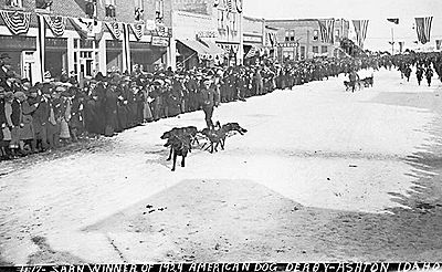 Ashton, being at the head of the Snake River Plain
and at the end of the Yellowstone moisture channel, gets as much snow as the typical ski town in Colorado (See "Effects on Climate" in article "Snake River Plain
"). Ashton was also the wintertime rail terminus for the region and where there was considerable development in the higher country north and east of Ashton, there arose a need for wintertime travel to the snowbound areas around Ashton. People began using the only wintertime transportation available at the time…dogsled. There became several accomplished mushers
in the area whose livelihood became their dog teams. The many mushers, dog teams, and their abilities were fun topics of conversation and it was not long before a race was organized that, by fate, would become the world famous American Dog Derby.
The legend goes that a few of the boys were socializing in the barbershop one quiet winter day when Jay Ball, a beloved Ashton businessman, hatched his idea of a dog race after reading about dog races held in Alaska and Canada. The idea resonated with local musher's and businessmen alike and the first race, a simple 55 miles (88.5 km) run down the unplowed Yellowstone Branch from West Yellowstone to Ashton, was held on March 4, 1917. A blizzard held up the finish making spectators wait two days to see what was supposed to be a one day race, but it was enough of a success that it was promoted and held again the following year. Union Pacific Railroad, always advancing their interests, helped to promote the races. The second race, designed to be more spectator friendly, was held in the open fields around Ashton on a figure-eight course with Ashton at the intersection so that teams would come running through town twice each lap. Interest in the American Dog Derby grew. Union Pacific brought spectators in special trains and by the early twenties, thousands of people thronged the streets of Ashton each February to see musher's and dogs come charging down Main Street on one of their laps. It may have been Ashton’s beautiful view of the Tetons, it may have been the happy cast of characters involved, but for whatever reason, by 1923, the American Dog Derby had captured the imagination of the western world. Newspaper correspondents and newsreel cameramen came from distant cities seeking the inside story of the American Dog Derby while crowds grew to 10,000 or more people in this town of less than two thousand. Winning musher's became celebrities and some became wealthy. A female musher nicknamed Whistling Lyd toured the United States and Canada, appeared in a movie, and may have been on her way to being a movie star when she died of pneumonia in 1930. The buildup to and the results of the American Dog Derby were reported by newspapers and by newsreels in the Americas, in Europe, and elsewhere. Ashton was dubbed, “the best known American town in the world.”
Seed Potatoes
Ashton was first and foremost a farming community. The soil of the area is rich and the water is plentiful. Shortly after the first settlers arrived in the 1890s, several canals were developed to divert water from streams running off the Yellowstone Plateau
and Teton Range
. Some farmland, mostly to the east, is high enough and close enough to the Teton Range that crops can grow without irrigation due to increased rainfall. The relatively high altitude limited crops to those requiring a short growing season such as grain and alfalfa. Seed potatoes were not tried as a crop until 1920 but as it turns out, the area is perfect for seed potatoes. The short growing season keeps the potatoes small, as seed potatoes need to be, but it is the long cold winters, ironically, that creates the ideal conditions for seed. The longtime enemy to potato farming is potato blight which is a form of mold that reproduces from spores in the soil and sickens the potato plant. Ashton's long cold winters cleans the soil of these mold spores with a long, deep, and killing freeze. Potato blight never spreads because the soil is clean and free of spores each spring. After realizing this, farmers organized, hired inspectors, and began selling certified seed potatoes giving buyers comfort that Ashton seed was free of molds and disease. This enabled them to demand a premium price for these potatoes grown in the clean soils around Ashton and the area quickly became the largest seed potato producing area in the world as it is still known today.
of 2000, there were 1,129 people, 395 households, and 285 families residing in the city. The population density
was 2,065.0 people per square mile (792.6/km²). There were 466 housing units at an average density of 852.4 per square mile (327.1/km²). The racial makeup of the city was 86.71% White, 0.44% African American, 0.53% Native American, 0.09% Asian, 11.43% from other races
, and 0.80% from two or more races. Hispanic or Latino of any race were 13.91% of the population.
There were 395 households out of which 38.0% had children under the age of 18 living with them, 60.3% were married couples
living together, 7.8% had a female householder with no husband present, and 27.6% were non-families. 26.3% of all households were made up of individuals and 15.9% had someone living alone who was 65 years of age or older. The average household size was 2.79 and the average family size was 3.43.
In the city the population was spread out with 33.0% under the age of 18, 7.5% from 18 to 24, 24.5% from 25 to 44, 17.4% from 45 to 64, and 17.4% who were 65 years of age or older. The median age was 33 years. For every 100 females there were 92.3 males. For every 100 females age 18 and over, there were 92.9 males.
The median income for a household in the city was $30,282, and the median income for a family was $35,515. Males had a median income of $27,273 versus $22,000 for females. The per capita income
for the city was $13,731. About 13.7% of families and 19.7% of the population were below the poverty line, including 28.2% of those under age 18 and 12.8% of those age 65 or over.
Fremont County, Idaho
Fremont County is a county located in the U.S. state of Idaho. The county was established in 1893, and was named for the explorer John C. Frémont. As of the 2000 census the county had a population of 11,819 . The county seat and largest city is St. Anthony...
, Idaho
Idaho
Idaho is a state in the Rocky Mountain area of the United States. The state's largest city and capital is Boise. Residents are called "Idahoans". Idaho was admitted to the Union on July 3, 1890, as the 43rd state....
, United States
United States
The United States of America is a federal constitutional republic comprising fifty states and a federal district...
. It is part of the Rexburg, Idaho
Rexburg, Idaho
-Demographics:As of the census of 2000, there were 17,257 people, 4,274 households, and 2,393 families residing in the city. The population density was 3,534.4 people per square mile . There were 4,533 housing units at an average density of 928.4 per square mile...
Micropolitan Statistical Area
Rexburg micropolitan area
The Rexburg Micropolitan Statistical Area, as defined by the United States Census Bureau, is an area consisting of two counties in eastern Idaho, anchored by the city of Rexburg....
. The population was 1,129 at the 2000 census. The district is noted for seed potato production and bills itself as the world's largest seed potato growing area.
Geography and climate
Ashton is located at 44°4′20"N 111°26′52"W (44.072092, -111.447858). It is at an elevation of 5260 feet (1,603.2 m).According to the United States Census Bureau
United States Census Bureau
The United States Census Bureau is the government agency that is responsible for the United States Census. It also gathers other national demographic and economic data...
, the city has a total area of 0.6 square miles (1.6 km²), all of it land.
Ashton is 18 miles (29 km) from the southwest corner of Yellowstone National Park
Yellowstone National Park
Yellowstone National Park, established by the U.S. Congress and signed into law by President Ulysses S. Grant on March 1, 1872, is a national park located primarily in the U.S. state of Wyoming, although it also extends into Montana and Idaho...
, 24 miles (38.6 km) from Grand Teton National Park
Grand Teton National Park
Grand Teton National Park is a United States National Park located in northwestern Wyoming, U.S. The Park consists of approximately and includes the major peaks of the long Teton Range as well as most of the northern sections of the valley known as Jackson Hole. Only south of Yellowstone...
, and 39 miles (62.8 km) from the Grand Teton
Grand Teton
Grand Teton is the highest mountain in Wyoming's Grand Teton National Park, and a classic destination in American mountaineering.- Geography :...
with a clear view. Ashton is surrounded by farmland but is less than five miles (8 km) from the Targhee National Forest. There are four rivers within 10 miles (16.1 km) of Ashton. They are the Henry's Fork of the Snake River, Fall River, the Teton River, and Warm River and all are outstanding trout streams. There are three notable waterfalls nearby, Upper Mesa Falls and Lower Mesa Falls both on the Henry's Fork and Cave Falls on Fall River.
Moisture Channel
St. Anthony, Idaho
St. Anthony is a city in and the county seat of Fremont County, Idaho, United States. The population was 3,342 at the 2000 census. It is part of the Rexburg, Idaho Micropolitan Statistical Area.-Geography:St...
, only 13 miles (20.9 km) to the southwest receives only 14 inches (355.6 mm). This unusually high precipitation in the Ashton area is due to the unique geography of southern Idaho and Yellowstone. It is due to the Snake River Plain that was formed by the Yellowstone hotspot across southern Idaho. It forms a moisture channel that extends from the Pacific Ocean to the Ashton and Yellowstone area. For more information, see "Effects on Climate" in article "Snake River Plain
Snake River Plain
The Snake River Plain is a geologic feature located primarily within the state of Idaho in the United States of America. It stretches about westward from northwest of the state of Wyoming to the Idaho-Oregon border. The plain is a wide flat bow-shaped depression, and covers about a quarter of Idaho...
".
Temperature and Precipitation Averages for Ashton, Idaho
| Jan | Feb | Mar | Apr | May | Jun | Jul | Aug | Sep | Oct | Nov | Dec | Annual | |
|---|---|---|---|---|---|---|---|---|---|---|---|---|---|
| Mean Max. Temp (F) | 29.5 | 34.4 | 41.9 | 53.3 | 64.4 | 73.6 | 81.6 | 82.0 | 72.9 | 60.6 | 41.8 | 30.9 | 55.6 |
| Mean Min. Temp (F) | 8.5 | 13.4 | 21.1 | 29.3 | 36.9 | 42.3 | 46.2 | 44.3 | 36.5 | 28.3 | 18.9 | 9.0 | 27.9 |
| Mean Precip (in.) | 2.25 | 1.67 | 1.60 | 1.47 | 2.38 | 1.64 | 1.12 | 1.08 | 1.18 | 1.41 | 2.03 | 2.25 | 20.08 |
History
RailroadIn 1900, the Union Pacific Railroad
Union Pacific Railroad
The Union Pacific Railroad , headquartered in Omaha, Nebraska, is the largest railroad network in the United States. James R. Young is president, CEO and Chairman....
, under the auspices of the OSL (Oregon Short Line) and St. Anthony Railroad Company, brought the railroad into the Upper Snake River Valley from Idaho Falls to St. Anthony, Idaho
St. Anthony, Idaho
St. Anthony is a city in and the county seat of Fremont County, Idaho, United States. The population was 3,342 at the 2000 census. It is part of the Rexburg, Idaho Micropolitan Statistical Area.-Geography:St...
, 14 miles (22.5 km) southwest of what became Ashton. The venture had considerable local support and official support from the LDS Church. Following successful construction and operation of the St. Anthony Railroad, Union Pacific, under the auspices of the OSL and the Yellowstone Park Railroad Company, began plans for another railroad from St. Anthony to the Madison River entrance of Yellowstone National Park
Yellowstone National Park
Yellowstone National Park, established by the U.S. Congress and signed into law by President Ulysses S. Grant on March 1, 1872, is a national park located primarily in the U.S. state of Wyoming, although it also extends into Montana and Idaho...
or to what is now known as West Yellowstone
West Yellowstone, Montana
West Yellowstone is a town in Gallatin County, Montana, adjacent to Yellowstone National Park. The population was 1,177 at the 2000 census. The town is served by Yellowstone Airport...
. For years, Union Pacific wanted improved rail access to Yellowstone’s geyser basins and now to Old Faithful Inn
Old Faithful Inn
-Sources:*Barringer, Mark Daniel. Selling Yellowstone: Capitalism and the Construction of Nature, Lawrence, Kansas: University Press of Kansas, 2002. ISBN 978-070061167-3...
, that opened in 1904. Old Faithful Inn was only 30 miles (48.3 km) from the Madison River entrance, nearly half the distance from the Northern Entrance at Gardiner, Montana
Gardiner, Montana
Gardiner is a census-designated place in Park County, Montana, United States, along the 45th parallel. The population was 851 at the 2000 census....
that was served by the Northern Pacific Railroad. The planned route for the new railroad was through Marysville, up Warm River Canyon into the forested Island Park country, and on over the continental divide at Rea’s Pass into what became West Yellowstone, Montana
West Yellowstone, Montana
West Yellowstone is a town in Gallatin County, Montana, adjacent to Yellowstone National Park. The population was 1,177 at the 2000 census. The town is served by Yellowstone Airport...
. Despite the obvious economic advantages and support, the residents of Marysville, perfectly happy without a railroad, resisted the new railroad intruding upon their land and into their lives. The matter was expeditiously resolved when Union Pacific decided to build the railroad through a new town one mile (1.6 km) west of Marysville named after the OSL Chief Engineer, William Ashton. The founding of Ashton and the first scheduled train service to Ashton both occurred in 1906 with predictable results. Ashton quickly sprang to life while Marysville slowly declined into near oblivion. One of the two founding fathers, H. G. “Fess” Fuller, became the long-time Mayor of Ashton and the other, Charles C. Moore
Charles C. Moore
Charles Calvin Moore was the 13th Governor of Idaho, serving from 1923 until 1927.Moore served in the Idaho Legislature as a member of the Idaho State House of Representatives from 1903 to 1906. He was elected the 14th Lieutenant Governor of Idaho in 1918 and served in that capacity during the...
, went on to become Governor of Idaho
Idaho
Idaho is a state in the Rocky Mountain area of the United States. The state's largest city and capital is Boise. Residents are called "Idahoans". Idaho was admitted to the Union on July 3, 1890, as the 43rd state....
.
The Yellowstone Branch, as the new railroad was known, was very unusual in that it was built primarily for passenger service and secondarily for freight. Aesthetic stone depots, rather than standard wooden ones, were built at Rexburg, Idaho
Rexburg, Idaho
-Demographics:As of the census of 2000, there were 17,257 people, 4,274 households, and 2,393 families residing in the city. The population density was 3,534.4 people per square mile . There were 4,533 housing units at an average density of 928.4 per square mile...
and at West Yellowstone, Montana
West Yellowstone, Montana
West Yellowstone is a town in Gallatin County, Montana, adjacent to Yellowstone National Park. The population was 1,177 at the 2000 census. The town is served by Yellowstone Airport...
to lure and impress tourists traveling to Yellowstone National Park
Yellowstone National Park
Yellowstone National Park, established by the U.S. Congress and signed into law by President Ulysses S. Grant on March 1, 1872, is a national park located primarily in the U.S. state of Wyoming, although it also extends into Montana and Idaho...
and to Old Faithful Inn
Old Faithful Inn
-Sources:*Barringer, Mark Daniel. Selling Yellowstone: Capitalism and the Construction of Nature, Lawrence, Kansas: University Press of Kansas, 2002. ISBN 978-070061167-3...
. In addition to regular freight and passenger service, there were two special named trains, the Yellowstone Special and the Yellowstone Express that ran to West Yellowstone in the summer tourist season. From Ashton north, the railroad was never plowed of snow, except in spring, so that Ashton became the wintertime rail terminus for the entire region.
Development
Beginning in 1910, Ashton was the railhead used for the construction of Jackson Lake Dam
Jackson Lake Dam
Jackson Lake Dam is a concrete and earth-fill dam at the outlet of Jackson Lake in northwestern Wyoming, USA. The lake and dam are situated within Grand Teton National Park in Teton County. The Snake River emerges from the dam and flows about through Wyoming, Idaho, Oregon, and Washington to its...
in Grand Teton National Park
Grand Teton National Park
Grand Teton National Park is a United States National Park located in northwestern Wyoming, U.S. The Park consists of approximately and includes the major peaks of the long Teton Range as well as most of the northern sections of the valley known as Jackson Hole. Only south of Yellowstone...
by the Bureau of Reclamation. For several years, materials and equipment were freighted by wagon from the Reclamation Building in Ashton to the dam site at Moran, Wyoming on what was known as the Ashton-Moran Road or Reclamation Road, as the locals called it, that ran 56 miles (90.1 km) over the north end of the Teton Range
Teton Range
The Teton Range is a mountain range of the Rocky Mountains in North America. A north-south range, it is on the Wyoming side of the state's border with Idaho, just south of Yellowstone National Park. Most of the range is in Grand Teton National Park....
. Union Pacific then built the Teton Valley Branch railroad to Driggs
Driggs, Idaho
Driggs is a city in Teton County, Idaho, United States. It is part of the Jackson, WY-ID Micropolitan Statistical Area, and is located in Teton Valley. The population was 1,100 at the 2000 census. The city is the county seat of Teton County...
and Victor
Victor, Idaho
Victor is a city in Teton County, Idaho, United States. The population was 840 at the 2000 census. It is part of the Jackson, WY-ID Micropolitan Statistical Area.-Geography:Victor is located at...
from Ashton and completed in 1912. They built an engine house and other railroad facilities in Ashton to service the Teton Valley Branch and the Yellowstone Branch. These and further developments in the area soon made Ashton prosper and become one of the more important towns in Eastern Idaho.
American Dog Derby
Snake River Plain
The Snake River Plain is a geologic feature located primarily within the state of Idaho in the United States of America. It stretches about westward from northwest of the state of Wyoming to the Idaho-Oregon border. The plain is a wide flat bow-shaped depression, and covers about a quarter of Idaho...
and at the end of the Yellowstone moisture channel, gets as much snow as the typical ski town in Colorado (See "Effects on Climate" in article "Snake River Plain
Snake River Plain
The Snake River Plain is a geologic feature located primarily within the state of Idaho in the United States of America. It stretches about westward from northwest of the state of Wyoming to the Idaho-Oregon border. The plain is a wide flat bow-shaped depression, and covers about a quarter of Idaho...
"). Ashton was also the wintertime rail terminus for the region and where there was considerable development in the higher country north and east of Ashton, there arose a need for wintertime travel to the snowbound areas around Ashton. People began using the only wintertime transportation available at the time…dogsled. There became several accomplished mushers
Mushing
Mushing is a general term for a sport or transport method powered by dogs, and includes carting, pulka, scootering, sled dog racing, skijoring, freighting, and weight pulling. More specifically, it implies the use of one or more dogs to pull a sled on snow or a rig on dry land...
in the area whose livelihood became their dog teams. The many mushers, dog teams, and their abilities were fun topics of conversation and it was not long before a race was organized that, by fate, would become the world famous American Dog Derby.
The legend goes that a few of the boys were socializing in the barbershop one quiet winter day when Jay Ball, a beloved Ashton businessman, hatched his idea of a dog race after reading about dog races held in Alaska and Canada. The idea resonated with local musher's and businessmen alike and the first race, a simple 55 miles (88.5 km) run down the unplowed Yellowstone Branch from West Yellowstone to Ashton, was held on March 4, 1917. A blizzard held up the finish making spectators wait two days to see what was supposed to be a one day race, but it was enough of a success that it was promoted and held again the following year. Union Pacific Railroad, always advancing their interests, helped to promote the races. The second race, designed to be more spectator friendly, was held in the open fields around Ashton on a figure-eight course with Ashton at the intersection so that teams would come running through town twice each lap. Interest in the American Dog Derby grew. Union Pacific brought spectators in special trains and by the early twenties, thousands of people thronged the streets of Ashton each February to see musher's and dogs come charging down Main Street on one of their laps. It may have been Ashton’s beautiful view of the Tetons, it may have been the happy cast of characters involved, but for whatever reason, by 1923, the American Dog Derby had captured the imagination of the western world. Newspaper correspondents and newsreel cameramen came from distant cities seeking the inside story of the American Dog Derby while crowds grew to 10,000 or more people in this town of less than two thousand. Winning musher's became celebrities and some became wealthy. A female musher nicknamed Whistling Lyd toured the United States and Canada, appeared in a movie, and may have been on her way to being a movie star when she died of pneumonia in 1930. The buildup to and the results of the American Dog Derby were reported by newspapers and by newsreels in the Americas, in Europe, and elsewhere. Ashton was dubbed, “the best known American town in the world.”
Seed Potatoes
Ashton was first and foremost a farming community. The soil of the area is rich and the water is plentiful. Shortly after the first settlers arrived in the 1890s, several canals were developed to divert water from streams running off the Yellowstone Plateau
Yellowstone Plateau
The Yellowstone Plateau volcanic field is a geological feature found in the U.S. state of Wyoming. It is a popular site for tourists.The plateau developed through three volcanic cycles spanning two million years that included some of the world's largest known eruptions...
and Teton Range
Teton Range
The Teton Range is a mountain range of the Rocky Mountains in North America. A north-south range, it is on the Wyoming side of the state's border with Idaho, just south of Yellowstone National Park. Most of the range is in Grand Teton National Park....
. Some farmland, mostly to the east, is high enough and close enough to the Teton Range that crops can grow without irrigation due to increased rainfall. The relatively high altitude limited crops to those requiring a short growing season such as grain and alfalfa. Seed potatoes were not tried as a crop until 1920 but as it turns out, the area is perfect for seed potatoes. The short growing season keeps the potatoes small, as seed potatoes need to be, but it is the long cold winters, ironically, that creates the ideal conditions for seed. The longtime enemy to potato farming is potato blight which is a form of mold that reproduces from spores in the soil and sickens the potato plant. Ashton's long cold winters cleans the soil of these mold spores with a long, deep, and killing freeze. Potato blight never spreads because the soil is clean and free of spores each spring. After realizing this, farmers organized, hired inspectors, and began selling certified seed potatoes giving buyers comfort that Ashton seed was free of molds and disease. This enabled them to demand a premium price for these potatoes grown in the clean soils around Ashton and the area quickly became the largest seed potato producing area in the world as it is still known today.
Demographics
As of the censusCensus
A census is the procedure of systematically acquiring and recording information about the members of a given population. It is a regularly occurring and official count of a particular population. The term is used mostly in connection with national population and housing censuses; other common...
of 2000, there were 1,129 people, 395 households, and 285 families residing in the city. The population density
Population density
Population density is a measurement of population per unit area or unit volume. It is frequently applied to living organisms, and particularly to humans...
was 2,065.0 people per square mile (792.6/km²). There were 466 housing units at an average density of 852.4 per square mile (327.1/km²). The racial makeup of the city was 86.71% White, 0.44% African American, 0.53% Native American, 0.09% Asian, 11.43% from other races
Race (United States Census)
Race and ethnicity in the United States Census, as defined by the Federal Office of Management and Budget and the United States Census Bureau, are self-identification data items in which residents choose the race or races with which they most closely identify, and indicate whether or not they are...
, and 0.80% from two or more races. Hispanic or Latino of any race were 13.91% of the population.
There were 395 households out of which 38.0% had children under the age of 18 living with them, 60.3% were married couples
Marriage
Marriage is a social union or legal contract between people that creates kinship. It is an institution in which interpersonal relationships, usually intimate and sexual, are acknowledged in a variety of ways, depending on the culture or subculture in which it is found...
living together, 7.8% had a female householder with no husband present, and 27.6% were non-families. 26.3% of all households were made up of individuals and 15.9% had someone living alone who was 65 years of age or older. The average household size was 2.79 and the average family size was 3.43.
In the city the population was spread out with 33.0% under the age of 18, 7.5% from 18 to 24, 24.5% from 25 to 44, 17.4% from 45 to 64, and 17.4% who were 65 years of age or older. The median age was 33 years. For every 100 females there were 92.3 males. For every 100 females age 18 and over, there were 92.9 males.
The median income for a household in the city was $30,282, and the median income for a family was $35,515. Males had a median income of $27,273 versus $22,000 for females. The per capita income
Per capita income
Per capita income or income per person is a measure of mean income within an economic aggregate, such as a country or city. It is calculated by taking a measure of all sources of income in the aggregate and dividing it by the total population...
for the city was $13,731. About 13.7% of families and 19.7% of the population were below the poverty line, including 28.2% of those under age 18 and 12.8% of those age 65 or over.