
Midwest to Mid-Atlantic United States tornado outbreak of 2002
Encyclopedia
The 2002 Midwest to Mid-Atlantic United States tornado outbreak of April 27, 2002 and April 28, 2002 was a widespread outbreak that moved from west to east over a Saturday and Sunday. Iowa
, Kansas
, Missouri
and Nebraska
were affected on the 27th; tornadoes were reported in Illinois
, Indiana
, Kentucky
, Maryland
, New York
, Ohio
, Pennsylvania
, Tennessee
, Virginia
and West Virginia
on the 28th. Generally, tornado reports were widely scattered in each state, but significant to severe damage was noted in multiple states. Overall, the outbreak was responsible for 7 deaths, 256 injuries and a total in excess of $224 million in tornado damage, with wind and hail adding to the damage total.
A total of 6 tornadoes, all rated F0 or F1 in strength (see Fujita scale
) were confirmed in these states. These first reported tornadoes of the outbreak - on the afternoon of the 27th - caused little or no damage.
.
spawned an additional F2 tornado at Bradyville, TN.
recorded during this outbreak, after crossing into Virginia and Maryland.
 The worst damage of the outbreak was seen in parts of these states. A supercell that had earlier produced the St. Joseph, WV tornado crossed the central Appalachian mountains
, producing numerous hail and wind damage reports. This storm spawned its second tornado (F2) in Shenandoah County, Virginia
, blowing trucks from I-81. Shortly thereafter, funnel clouds were reported with the same storm in Fauquier County, Virginia
and Prince William County, Virginia
(at the southern edge of the metro Washington, D.C.
area). Crossing the Potomac River
into Maryland, the storm then spawned a series of powerful (F2, F3 and F4) tornadoes that moved along a nearly continual path starting south of Indian Head, Maryland
and continuing into La Plata, Maryland
, devastating La Plata's business district. Damage surveys revealed this tornado to be an F4, though a preliminary NWS survey first categorized it as an F5.
Continuing east, damage fluctuated between F2 and F4 levels through eastern Charles County, Maryland
and southern Calvert County, Maryland
. The tornado or tornadoes made a 10 mile crossing of the Chesapeake Bay
and emerged on the Eastern Shore
in Dorchester County, Maryland
. Now weakened to consistent F2 strength (still with brief F3 bursts), the storm dissipated several miles west of Salisbury, Maryland
. This storm produced debris fallout 66 miles away, at Federalsburg, Maryland
, and also in southern Delaware
, and hail up to 4.5 inches in diameter was reported in northern Charles County.
Farther south, tornadoes also produced damage in the City of Bedford, Virginia
(west of Lynchburg
), and near Emporia, Virginia
, along I-95
just north of the North Carolina
state line.
Much of La Plata had previously been destroyed by an F4 tornado on November 9, 1926.
A total of $125 million in damage, 4 fatalities and 122 injuries were directly caused by the Maryland storms (the most expensive in the history of the state). Another $8 million in damage, along with 17 injuries were reported in Virginia.
Iowa
Iowa is a state located in the Midwestern United States, an area often referred to as the "American Heartland". It derives its name from the Ioway people, one of the many American Indian tribes that occupied the state at the time of European exploration. Iowa was a part of the French colony of New...
, Kansas
Kansas
Kansas is a US state located in the Midwestern United States. It is named after the Kansas River which flows through it, which in turn was named after the Kansa Native American tribe, which inhabited the area. The tribe's name is often said to mean "people of the wind" or "people of the south...
, Missouri
Missouri
Missouri is a US state located in the Midwestern United States, bordered by Iowa, Illinois, Kentucky, Tennessee, Arkansas, Oklahoma, Kansas and Nebraska. With a 2010 population of 5,988,927, Missouri is the 18th most populous state in the nation and the fifth most populous in the Midwest. It...
and Nebraska
Nebraska
Nebraska is a state on the Great Plains of the Midwestern United States. The state's capital is Lincoln and its largest city is Omaha, on the Missouri River....
were affected on the 27th; tornadoes were reported in Illinois
Illinois
Illinois is the fifth-most populous state of the United States of America, and is often noted for being a microcosm of the entire country. With Chicago in the northeast, small industrial cities and great agricultural productivity in central and northern Illinois, and natural resources like coal,...
, Indiana
Indiana
Indiana is a US state, admitted to the United States as the 19th on December 11, 1816. It is located in the Midwestern United States and Great Lakes Region. With 6,483,802 residents, the state is ranked 15th in population and 16th in population density. Indiana is ranked 38th in land area and is...
, Kentucky
Kentucky
The Commonwealth of Kentucky is a state located in the East Central United States of America. As classified by the United States Census Bureau, Kentucky is a Southern state, more specifically in the East South Central region. Kentucky is one of four U.S. states constituted as a commonwealth...
, Maryland
Maryland
Maryland is a U.S. state located in the Mid Atlantic region of the United States, bordering Virginia, West Virginia, and the District of Columbia to its south and west; Pennsylvania to its north; and Delaware to its east...
, New York
New York
New York is a state in the Northeastern region of the United States. It is the nation's third most populous state. New York is bordered by New Jersey and Pennsylvania to the south, and by Connecticut, Massachusetts and Vermont to the east...
, Ohio
Ohio
Ohio is a Midwestern state in the United States. The 34th largest state by area in the U.S.,it is the 7th‑most populous with over 11.5 million residents, containing several major American cities and seven metropolitan areas with populations of 500,000 or more.The state's capital is Columbus...
, Pennsylvania
Pennsylvania
The Commonwealth of Pennsylvania is a U.S. state that is located in the Northeastern and Mid-Atlantic regions of the United States. The state borders Delaware and Maryland to the south, West Virginia to the southwest, Ohio to the west, New York and Ontario, Canada, to the north, and New Jersey to...
, Tennessee
Tennessee
Tennessee is a U.S. state located in the Southeastern United States. It has a population of 6,346,105, making it the nation's 17th-largest state by population, and covers , making it the 36th-largest by total land area...
, Virginia
Virginia
The Commonwealth of Virginia , is a U.S. state on the Atlantic Coast of the Southern United States. Virginia is nicknamed the "Old Dominion" and sometimes the "Mother of Presidents" after the eight U.S. presidents born there...
and West Virginia
West Virginia
West Virginia is a state in the Appalachian and Southeastern regions of the United States, bordered by Virginia to the southeast, Kentucky to the southwest, Ohio to the northwest, Pennsylvania to the northeast and Maryland to the east...
on the 28th. Generally, tornado reports were widely scattered in each state, but significant to severe damage was noted in multiple states. Overall, the outbreak was responsible for 7 deaths, 256 injuries and a total in excess of $224 million in tornado damage, with wind and hail adding to the damage total.
April 27 event
| F# Fujita scale The Fujita scale , or Fujita-Pearson scale, is a scale for rating tornado intensity, based primarily on the damage tornadoes inflict on human-built structures and vegetation... |
Location | County | Time (UTC) | Path length | Damage | |
|---|---|---|---|---|---|---|
| Nebraska Nebraska Nebraska is a state on the Great Plains of the Midwestern United States. The state's capital is Lincoln and its largest city is Omaha, on the Missouri River.... |
||||||
| F1 | W of Crete Crete, Nebraska Crete is a city in Saline County, Nebraska, United States. The population was 6,960 at the 2010 census.-Geography:Crete is located at .According to the United States Census Bureau, the city has a total area of , all of it land.... |
Saline Saline County, Nebraska -Demographics:As of the census of 2000, there were 13,843 people, 5,188 households, and 3,507 families residing in the county. The population density was 24 people per square mile . There were 5,611 housing units at an average density of 10 per square mile... |
2006 | 4.5 miles (7.2 km) |
One barn and some fences were destroyed. Some home had minor damage | |
| F0 | S of Milford Milford, Nebraska Milford is a city in Seward County, Nebraska, United States. It is part of the Lincoln, Nebraska Metropolitan Statistical Area. The population was 2,070 at the 2000 census.-Geography:Milford is located at .... |
Seward Seward County, Nebraska -Demographics:As of the census of 2000, there were 16,496 people, 6,013 households, and 4,215 families residing in the county. The population density was 29 people per square mile . There were 6,428 housing units at an average density of 11 per square mile... |
2025 | 0.1 miles (0.16 km) |
Brief tornado with no damage | |
| Kansas Kansas Kansas is a US state located in the Midwestern United States. It is named after the Kansas River which flows through it, which in turn was named after the Kansa Native American tribe, which inhabited the area. The tribe's name is often said to mean "people of the wind" or "people of the south... |
||||||
| F0 | SW of Effingham Effingham, Kansas Effingham is a city in Atchison County, Kansas, United States. The population was 588 at the 2000 census. Effingham was named in honor of Effingham H. Nichols, an early promoter of the Central Branch Union Pacific Railroad.-Geography:... |
Atchison Atchison County, Kansas Atchison County is a county located in Northeast Kansas, in the Central United States. As of the 2010 census, the county population was 16,924. Its county seat and most populous city is Atchison. The county is named in honor of David Rice Atchison, a United States Senator from Missouri... |
2110 | 0.5 miles (0.8 km) |
A grain truck was blown over and one home had windows blown out. Two sheds were destroyed | |
| Iowa Iowa Iowa is a state located in the Midwestern United States, an area often referred to as the "American Heartland". It derives its name from the Ioway people, one of the many American Indian tribes that occupied the state at the time of European exploration. Iowa was a part of the French colony of New... |
||||||
| F0 | NW of Percival | Fremont Fremont County, Iowa -2010 census:The 2010 census recorded a population of 7,441 in the county, with a population density of . There were 3,431 housing units, of which 3,064 were occupied.-2000 census:... |
2141 | unknown | Brief tornado with no damage | |
| F0 | NW of Thurman Thurman, Iowa Thurman is a city in Fremont County, Iowa, United States. The population was 236 at the 2000 census.-Geography:Thurman is located at .According to the United States Census Bureau, the city has a total area of , all of it land.... |
Fremont Fremont County, Iowa -2010 census:The 2010 census recorded a population of 7,441 in the county, with a population density of . There were 3,431 housing units, of which 3,064 were occupied.-2000 census:... |
2150 | unknown | Brief tornado with no damage | |
| F0 | S of Pacific Junction Pacific Junction, Iowa Pacific Junction is a city in Mills County, Iowa, United States. The population was 507 at the 2000 census.-History:"PJ" was established by the railroad in 1871 to serve as the western terminus of the Burlington and Missouri River Railroad, the eastern terminus of the Nebraska Burlington & Missouri... |
Mills Mills County, Iowa -2010 census:The 2010 census recorded a population of 15,059 in the county, with a population density of . There were 6,109 housing units, of which 5,605 were occupied.-2000 census:... |
2158 | unknown | Brief tornado with no damage | |
| Illinois Illinois Illinois is the fifth-most populous state of the United States of America, and is often noted for being a microcosm of the entire country. With Chicago in the northeast, small industrial cities and great agricultural productivity in central and northern Illinois, and natural resources like coal,... |
||||||
| F1 | E of Belleville Belleville, Illinois Belleville is a city in St. Clair County, Illinois, United States. As of the 2010 census, the city has a population of 44,478. It is the eighth-most populated city outside of the Chicago Metropolitan Area and the most populated city south of Springfield in the state of Illinois. It is the county... |
St. Clair St. Clair County, Illinois St. Clair County is a county located in the U.S. state of Illinois. In 1970, the U.S. Census Bureau placed the mean center of U.S. population in St. Clair County. According to the 2010 census, it has a population of 270,056, which is an increase of 5.5% from 256,082 in 2000. Its county seat is... |
0335 | 1.7 miles (2.7 km) |
34 homes, an elementary school and two large buildings were damaged | |
| F1 | E of Kenner Kenner, Illinois Kenner is an unincorporated community in Clay County, Illinois, United States. Kenner is located along a railroad line southwest of Flora.... |
Clay Clay County, Illinois Clay County is a county located in the U.S. state of Illinois. In 1950, the U.S. Census Bureau placed the mean center of U.S. population in Clay County. According to the 2010 census, it has a population of 13,815, which is a decrease of 5.1% from 14,560 in 2000... |
0505 | 5 miles (8 km) |
A mobile home and outbuilding were destroyed, a garage was turned on its foundation, a propane tank was thrown a certain distance and a car was flipped injuring its occupants. 3 homes and a mobile home were also damaged | |
| F2 | N of Raleigh Raleigh, Illinois Raleigh is a village in Saline County, Illinois, United States. The population was 330 at the 2000 census.-Geography:Raleigh is located at .According to the United States Census Bureau, the village has a total area of , all of it land.-History:... |
Saline Saline County, Illinois Saline County is a county located in the U.S. state of Illinois. According to the 2010 census, it has a population of 24,913, which is a decrease of 6.8% from 26,733 in 2000. Its county seat is Harrisburg. Saline County is home to the smallest post office and the largest KFC in the United States.... |
0607 | 7.5 miles (12 km) |
55 structures were damaged or destroyed | |
| F3 | NE of Valley Mission to NE of Cypress Cypress, Illinois Cypress is a village in Johnson County, Illinois, United States. The population was 271 at the 2000 census.-Geography:Cypress is located at .... |
Union, Johnson | 0618 | 19.3 miles (30.9 km) |
1 death Several wood house and trailers were destroyed with 75 homes damaged in Union County while in Johnson County, 50 structures were damaged including a school | |
| F2 | NW of Ganntown | Johnson | 0646 | 7 miles (11.2 km) |
Three mobile homes were heavily damaged or destroyed injuring 2 | |
| F3 | N of Reevesville to SE of Joy, KY | Pope, Livingston, KY Livingston County, Kentucky Livingston County is a county located in the U.S. state of Kentucky. As of 2000, the population was 9,804. Its county seat is Smithland. The county is named for Robert R. Livingston... |
0659 | 22 miles (35.2 km) |
A brick home and two mobile homes were destroyed while farm buildings and a few homes were damaged. | |
| Missouri Missouri Missouri is a US state located in the Midwestern United States, bordered by Iowa, Illinois, Kentucky, Tennessee, Arkansas, Oklahoma, Kansas and Nebraska. With a 2010 population of 5,988,927, Missouri is the 18th most populous state in the nation and the fifth most populous in the Midwest. It... |
||||||
| F2 | N of Willow Springs Willow Springs, Missouri Willow Springs is a city in Howell County, Missouri, in the Ozark Mountains of the United States. The population was 2,147 at the 2000 census.- History :... |
Howell Howell County, Missouri Howell County is a county located in South Central Missouri in the United States. As of the 2010 U.S. Census, the county's population was 40,400. The largest city and county seat is West Plains... |
0340 | 1.5 miles (2.4 km) |
One home was heavily damaged and six other homes and a barn were damaged. One church was rotated off its foundation and a radio tower toppled | |
| F3 | SW of Marble Hill Marble Hill, Missouri Marble Hill is a fourth-class city in central Bollinger County in Southeast Missouri in the United States. Located at the intersection of State Highway 34 and State Highway 51, it is the largest city in Bollinger and serves as the county seat . The population was 1,502 at the 2000 census... |
Bollinger Bollinger County, Missouri Bollinger County is a county located in Southeast Missouri in the United States. As of the 2010 U.S. Census, the county's population was 12,363; despite a 2009 estimate that showed the population to be 11,841. The county seat is Marble Hill, which is the only city in Bollinger County... |
0540 | 4 miles (6.4 km) |
1 death 6 residences were destroyed out of 19 that were heavily damaged. 50 outbuildings were damaged or destroyed. In addition to the fatality, 16 were injured | |
| F0 | SE of Hayward Hayward, Missouri Hayward is a village in Pemiscot County, Missouri, United States. The population was 123 at the 2000 census, at which time it was a town.-Geography:Hayward is located at .... |
New Madrid New Madrid County, Missouri New Madrid County is a county located in the Bootheel of southeast Missouri in the United States. As of the 2000 Census, the county's population was 19,760. A 2008 estimate, however, showed the population to be 17,589. The largest city and county seat is New Madrid... |
0729 | 0.1 miles (0.16 km) |
Damage limited to trees | |
| Kentucky Kentucky The Commonwealth of Kentucky is a state located in the East Central United States of America. As classified by the United States Census Bureau, Kentucky is a Southern state, more specifically in the East South Central region. Kentucky is one of four U.S. states constituted as a commonwealth... |
||||||
| F1 | N of Sheridan | Crittenden Crittenden County, Kentucky Crittenden County is a county located in the U.S. state of Kentucky.It was formed in 1842. As of 2000, the population was 9,384. Its county seat is Marion. The county is named for John J. Crittenden who was Governor of Kentucky 1848-1850... |
0735 | 2 miles (3.2 km) |
A few trailers were heavily damaged or destroyed | |
| F1 | SW of Repton | Crittenden Crittenden County, Kentucky Crittenden County is a county located in the U.S. state of Kentucky.It was formed in 1842. As of 2000, the population was 9,384. Its county seat is Marion. The county is named for John J. Crittenden who was Governor of Kentucky 1848-1850... |
0739 | 1 miles (1.6 km) |
Damage limited to trees | |
| F3 | SE of Piney to Hanson Hanson, Kentucky Hanson is a city in Hopkins County, Kentucky, United States. The population was 625 at the 2000 census. It is named for Henry B. Hanson, a civil engineer and surveyor who plotted the town for the Henderson and Nashville Railroad . CSX Transportation runs through Hanson and operates a siding track... |
Crittenden Crittenden County, Kentucky Crittenden County is a county located in the U.S. state of Kentucky.It was formed in 1842. As of 2000, the population was 9,384. Its county seat is Marion. The county is named for John J. Crittenden who was Governor of Kentucky 1848-1850... , Webster Webster County, Kentucky Webster County is a county located in the U.S. state of Kentucky. Webster County was formed in 1860 from parts of the counties of Henderson, Hopkins, and Union. As of 2000, the population is 14,120. Its county seat is Dixon. The county was named for American statesman Daniel Webster... , Hopkins Hopkins County, Kentucky Hopkins County is a county located in the U.S. state of Kentucky. It was formed in 1807. As of 2000, the population was 46,519. Its county seat is Madisonville. The county is named for General Samuel Hopkins, an officer in both the Revolutionary War and War of 1812, and later a Kentucky legislator... |
0749 | 22 miles (35.2 km) |
A dozen homes and farm buildings were damaged in Crittenden County. In Webster County, 16 mobile homes and 10 homes were destroyed while 100 homes were damaged 26 people were injured in that county. In Hopkins County, four chicken houses (with an estimated 45 000 chickens inside) were blown off their foundation and 10 to 15 residences were damaged. | |
| Tennessee Tennessee Tennessee is a U.S. state located in the Southeastern United States. It has a population of 6,346,105, making it the nation's 17th-largest state by population, and covers , making it the 36th-largest by total land area... |
||||||
| F1 | W of Tiptonville Tiptonville, Tennessee Tiptonville is a town in and the county seat of Lake County, Tennessee, United States. Its population was 2,439 as of the 2000 census. It is also home to the Northwest Correctional Complex, a maximum security prison, known for once housing mass murderer Jessie Dotson, Jr.-History:According to the... |
Lake | 0740 | 3.5 miles (5.6 km) |
11 mobile homes and a shed were destroyed while 12 mobiles homes and five homes were damaged | |
| Source: Tornado History Storm Data - April 27, 2002 |
||||||
April 28 event
| F# Fujita scale The Fujita scale , or Fujita-Pearson scale, is a scale for rating tornado intensity, based primarily on the damage tornadoes inflict on human-built structures and vegetation... |
Location | County | Time (UTC) | Path length | Damage | |
|---|---|---|---|---|---|---|
| Indiana Indiana Indiana is a US state, admitted to the United States as the 19th on December 11, 1816. It is located in the Midwestern United States and Great Lakes Region. With 6,483,802 residents, the state is ranked 15th in population and 16th in population density. Indiana is ranked 38th in land area and is... |
||||||
| F1 | SE of Tobinsport, IN Tobinsport, Indiana Tobinsport, Indiana is a small unincorporated community located along the Ohio River in Tobin Township, Perry County, Indiana, United States. Directly across the river is Cloverport, Kentucky. It is at the southernmost point of Perry County.... to SW of Garrett, KY |
Perry, IN Perry County, Indiana Perry County is a county located in the southwestern part of the U.S. state of Indiana. As of 2010, the population was 19,338. The county seat is Tell City. It is the hilliest county as well as one of the most forested counties of in Indiana as it features more than of Hoosier National Forest... , Breckinridge, KY Breckinridge County, Kentucky As of the census of 2000, there were 18,648 people, 7,324 households, and 5,309 families residing in the county. The population density was . There were 9,890 housing units at an average density of... , Meade, KY Meade County, Kentucky As of the census of 2000, there were 26,349 people, 9,470 households, and 7,396 families residing in the county. The population density was . There were 10,293 housing units at an average density of... |
0805 | 32.3 miles (51.7 km) |
1 death Several homes and outbuildings were destroyed with several other homes damaged. One church lost portions of its roof. The fatality was from a destroyed mobile home. | |
| Kentucky Kentucky The Commonwealth of Kentucky is a state located in the East Central United States of America. As classified by the United States Census Bureau, Kentucky is a Southern state, more specifically in the East South Central region. Kentucky is one of four U.S. states constituted as a commonwealth... |
||||||
| F1 | W of Hartford Hartford, Kentucky Hartford is a city in Ohio County, Kentucky, United States. The population was 2,571 at the 2000 census. It is the county seat of Ohio County. It is believed to be named for a deer crossing on the nearby Rough River.... |
Ohio Ohio County, Kentucky Ohio County is a county located in the U.S. state of Kentucky. As of 2000, the population was 22,916. Its county seat is Hartford. The county is named for the Ohio River, which originally formed its northern boundary. It is a dry county, which means that the sale of alcohol is restricted or... |
0840 | 9.5 miles (15.2 km) |
A mobile home and several outbuildings were destroyed. Several other homes and mobile homes were damaged. | |
| F1 | NW of Radcliff Radcliff, Kentucky Radcliff is a city in Hardin County, Kentucky, United States. The population was 21,961 at the 2000 census. It is included in the Elizabethtown, Kentucky Metropolitan Statistical Area.... |
Hardin Hardin County, Kentucky As of the census of 2000, there were 94,174 people, 34,497 households, and 25,355 families residing in the county. The population density was . There were 37,673 housing units at an average density of... |
0855 | 2 miles (3.2 km) |
26 homes were damaged including two that had their roof torn off | |
| F1 | S of Moutardier | Edmonson Edmonson County, Kentucky Edmonson County is a county located in the U.S. state of Kentucky. It was formed in 1826. As of 2007, the population was 11,978. It is included in the Bowling Green Metropolitan Statistical Area. Its county seat is Brownsville... |
0935 | 3 miles (4.8 km) |
Several homes lost their roof | |
| Tennessee Tennessee Tennessee is a U.S. state located in the Southeastern United States. It has a population of 6,346,105, making it the nation's 17th-largest state by population, and covers , making it the 36th-largest by total land area... |
||||||
| F0 | E of Whitlock | Henry | 0900 | 5 miles (8 km) |
20 homes had damage and three transmission towers were destroyed | |
| F3 | E of Rucker | Rutherford Rutherford County, Tennessee Rutherford County is a county located in the U.S. state of Tennessee. As of the 2010 census, it is the state's fifth-largest county by population with 262,604 people, an increase of 44.3 percent over the 2000 population of 182,023. Its county seat is Murfreesboro, which is also the geographic... |
1234 | 3.2 miles (5.1 km) |
7 mobile homes, 5 residences and 2 barns were destroyed while 2 mobile homes and 46 homes were damaged. 6 horse/cattle were killed and 31 people were injured. | |
| F2 | S of Bradyville | Cannon | 1245 | 9.9 miles (1.4 km) |
One residence and three mobile homes were destroyed, while six other mobile homes were damaged | |
| F0 | Mount Pleaseant area | Maury | 2042 | 0.1 miles (0.16 km) |
Brief tornado with no damage | |
| Ohio Ohio Ohio is a Midwestern state in the United States. The 34th largest state by area in the U.S.,it is the 7th‑most populous with over 11.5 million residents, containing several major American cities and seven metropolitan areas with populations of 500,000 or more.The state's capital is Columbus... |
||||||
| F2 | Crystal Springs to North Canton North Canton, Ohio As of the census of 2000, there were 16,369 people, 7,114 households, and 4,382 families residing in the city. The population density was 2,697.1 people per square mile . There were 7,506 housing units at an average density of 1,236.8 per square mile... |
Stark Stark County, Ohio Stark County is a county located in the U.S. state of Ohio. As of the 2010 census, the population was 375,586. It is included in the Canton-Massillon, Ohio Metropolitan Statistical Area.... |
1758 | 7.2 miles (11.5 km) |
300 homes, 38 other buildings and two schools were damaged with 25 structures and three businesses being destroyed. | |
| Pennsylvania Pennsylvania The Commonwealth of Pennsylvania is a U.S. state that is located in the Northeastern and Mid-Atlantic regions of the United States. The state borders Delaware and Maryland to the south, West Virginia to the southwest, Ohio to the west, New York and Ontario, Canada, to the north, and New Jersey to... |
||||||
| F0 | Sharpsville Sharpsville, Pennsylvania Sharpsville is a borough in Mercer County, Pennsylvania, along the Shenango River. The population was 4,500 at the 2000 census. It is part of the Youngstown–Warren–Boardman, OH-PA Metropolitan Statistical Area.-Geography:... area |
Mercer Mercer County, Pennsylvania Mercer County is a county located in the U.S. state of Pennsylvania. As of 2010, the population was 116,638. Its county seat is Mercer; Sharon is its largest city.... |
1835 | 6 miles (9.6 km) |
A fire tower was downed while a barn and a garage were damaged | |
| F1 | NW of Jackson Center Jackson Center, Pennsylvania Jackson Center is a borough in Mercer County, Pennsylvania, United States. The population was 221 at the 2000 census. It is part of the Youngstown–Warren–Boardman, OH-PA Metropolitan Statistical Area.-Geography:... to W of Mapledale |
Mercer Mercer County, Pennsylvania Mercer County is a county located in the U.S. state of Pennsylvania. As of 2010, the population was 116,638. Its county seat is Mercer; Sharon is its largest city.... , Venango Venango County, Pennsylvania Venango County is a county located in the U.S. state of Pennsylvania. As of the 2010 census, the population was 54,984. Its county seat is Franklin.-History:Venango County was created on March 12, 1800 from parts of Allegheny and Lycoming Counties... |
1845 | 16 miles (25.6 km) |
A garage, 4 barns, several decks and porches were destroyed while several homes, a factory building, sheds and garages were damaged. A mobile home was also flipped over. | |
| F1 | W of Meridian Meridian, Pennsylvania Meridian is a census-designated place in Butler County, Pennsylvania, United States. The population was 3,794 at the 2000 census.-History:... |
Butler Butler County, Pennsylvania -Demographics:As of the census of 2000, there were 174,083 people, 65,862 households, and 46,827 families residing in the county. The population density was 221 people per square mile . There were 69,868 housing units at an average density of 89 per square mile... |
1901 | 7 miles (11.2 km) |
Several homes and a barn had roof or siding damage | |
| F0 | NW of Maysville | Armstrong Armstrong County, Pennsylvania Armstrong County is a county located in the U.S. state of Pennsylvania. As of the 2010 census, the population was 68,941. It is located northeast of Pittsburgh and Allegheny County. Armstrong County was added to the Pittsburgh Metropolitan Statistical Area in 2003.The county seat is Kittanning... , Indiana Indiana County, Pennsylvania -Government and politics:As of November 2008, there are 58,077 registered voters in Indiana County .* Democratic: 26,653 * Republican: 24,159 * Other Parties: 7,265 -County commissioners:*Rodney Ruddock, Chairman, Republican... |
1945 | 4 miles (6.4 km) |
A steeple was toppled and a swimming pool was destroyed. A garage was also damaged while a home under construction was lifted from its foundation | |
| F2 | Indiana Indiana, Pennsylvania Indiana is a borough in and the county seat of Indiana County, Pennsylvania, United States. The population was 14,895 at the 2000 census.The borough and the region as a whole promotes itself as the "Christmas Tree Capital of the World" because the national Christmas Tree Grower's Association was... area |
Indiana Indiana County, Pennsylvania -Government and politics:As of November 2008, there are 58,077 registered voters in Indiana County .* Democratic: 26,653 * Republican: 24,159 * Other Parties: 7,265 -County commissioners:*Rodney Ruddock, Chairman, Republican... |
2000 | 5 miles (8 km) |
One home was destroyed while 18 others were damaged. Some garages and barns were also damaged and a large sign from a hotel blown into a car lot damaging several vehicles. | |
| F1 | NE of Deckers Point | Indiana Indiana County, Pennsylvania -Government and politics:As of November 2008, there are 58,077 registered voters in Indiana County .* Democratic: 26,653 * Republican: 24,159 * Other Parties: 7,265 -County commissioners:*Rodney Ruddock, Chairman, Republican... |
2010 | 2 miles (32 km) |
Several sheds and garages were destroyed while one home lost its roof | |
| F1 | S of Jerseytown Jerseytown, Pennsylvania Jerseytown is a census-designated place in Madison Township, Columbia County, Pennsylvania, United States. The population was 150 at the 2000 census... |
Columbia Columbia County, Pennsylvania As of the census of 2000, there were 64,151 people, 24,915 households, and 16,568 families residing in the county. The population density was 132 people per square mile . There were 27,733 housing units at an average density of 57 per square mile... |
2155 | 6 miles (9.6 km) |
Unknown damage | |
| F1 | N of McGillstown | Lebanon Lebanon County, Pennsylvania As of the census of 2000, there were 120,327 people and 32,771 families residing in the county. The population density was 332 people per square mile . There were 49,320 housing units at an average density of 136 per square mile... |
2213 | 1.5 miles (2.4 km) |
12 homes were damaged and 15 barns were damaged or destroyed | |
| New York New York New York is a state in the Northeastern region of the United States. It is the nation's third most populous state. New York is bordered by New Jersey and Pennsylvania to the south, and by Connecticut, Massachusetts and Vermont to the east... |
||||||
| F0 | NE of Springville Springville, New York Springville is a village in the southeast part of the town of Concord in Erie County, New York, United States. Springville is the principal community in the town and a major business location in south Erie County. The population was 4,252 at the 2000 census. It is part of the Buffalo–Niagara... |
Erie Erie County, New York Erie County is a county located in the U.S. state of New York. As of the 2010 census, the population was 919,040. The county seat is Buffalo. The county's name comes from Lake Erie, which in turn comes from the Erie tribe of American Indians who lived south and east of the lake before 1654.Erie... |
1850 | 0.7 miles (1.1 km) |
An outbuilding was damaged | |
| F2 | SE of Belfast Belfast, New York Belfast is a town in Allegany County, New York, United States. The population was 1,714 at the 2000 census. It was named after the city of Belfast in Northern Ireland.- History :The first settlers had arrived by 1804.... |
Allegany Allegany County, New York Allegany County is a county located in the U.S. state of New York. As of the 2010 census, the population was 48,946. Its name derives from a Delaware Indian word, applied by settlers of Western New York State to a trail that followed the Allegheny River. Its county seat is... |
1950 | 6.5 miles (10.4 km) |
A barn, garage and home were destroyed while a silo, barn and home were damaged | |
| West Virginia West Virginia West Virginia is a state in the Appalachian and Southeastern regions of the United States, bordered by Virginia to the southeast, Kentucky to the southwest, Ohio to the northwest, Pennsylvania to the northeast and Maryland to the east... |
||||||
| F1 | N of St. Joseph | Marshall Marshall County, West Virginia As of the census of 2000, there were 35,519 people, 14,207 households, and 10,101 families residing in the county. The population density was 116 people per square mile . There were 15,814 housing units at an average density of 52 per square mile... |
1915 | 1 miles (1.6 km) |
One barn was destroyed with several others damaged | |
| Virginia Virginia The Commonwealth of Virginia , is a U.S. state on the Atlantic Coast of the Southern United States. Virginia is nicknamed the "Old Dominion" and sometimes the "Mother of Presidents" after the eight U.S. presidents born there... |
||||||
| F1 | Bedford Bedford, Virginia Bedford is an independent city located within the confines of Bedford County in the U.S. state of Virginia. It serves as the county seat of Bedford County. As of 2010, the city had a total population of 6,222. The Bureau of Economic Analysis combines the city of Bedford with surrounding Bedford... |
Bedford Bedford County, Virginia As of the census of 2000, there were 60,371 people, 23,838 households, and 18,164 families residing in the county. The population density was 80 people per square mile . There were 26,841 housing units at an average density of 36 per square mile... |
2031 | 0.5 miles (0.8 km) |
Four businesses were destroyed while 25 homes and 58 businesses were damaged | |
| F2 | SW of Timberlake Timberlake, Virginia Timberlake is a census-designated place in Campbell County, Virginia, United States. The population was 10,683 at the 2000 census. It is part of the Lynchburg Metropolitan Statistical Area.-Geography:Timberlake is located at .... |
Bedford Bedford County, Virginia As of the census of 2000, there were 60,371 people, 23,838 households, and 18,164 families residing in the county. The population density was 80 people per square mile . There were 26,841 housing units at an average density of 36 per square mile... , Campbell Campbell County, Virginia As of the census of 2000, there were 51,078 people, 20,639 households, and 14,694 families residing in the county. The population density was 101 people per square mile . There were 22,088 housing units at an average density of 44 per square mile... |
2043 | 10 miles (16 km) |
22 homes, six businesses, one church and two dozen farm buildings were destroyed while 329 homes, several RV vehicles, two churches and 45 businesses were damaged. 12 people were injured | |
| F2 | N of Alpine Alpine, Virginia Alpine is an unincorporated community in Botetourt County, Virginia, United States.... |
Shenandoah Shenandoah County, Virginia As of the census of 2000, there were 35,075 people, 14,296 households, and 10,064 families residing in the county. The population density was 68 people per square mile . There were 16,709 housing units at an average density of 33 per square mile... |
2055 | 4 miles (6.4 km) |
4 homes were destroyed while 36 agriculture structures and 56 homes were damaged | |
| F1 | W of Emporia Emporia, Virginia Emporia is an independent city located within the confines of Greensville County, Virginia, United States. The population was estimated to be 5,927 in 2010. The Bureau of Economic Analysis combines the city of Emporia with surrounding Greensville county for statistical purposes... |
Greensville Greensville County, Virginia As of the census of 2000, there were 11,560 people, 3,375 households, and 2,396 families residing in the county. The population density was 39 people per square mile . There were 3,765 housing units at an average density of 13 per square mile... |
2335 | 6 miles (9.6 km) |
3 mobile homes were destroyed, while 50 homes, one business and an apartment complex were damaged | |
| Maryland Maryland Maryland is a U.S. state located in the Mid Atlantic region of the United States, bordering Virginia, West Virginia, and the District of Columbia to its south and west; Pennsylvania to its north; and Delaware to its east... |
||||||
| F4 | Rison Rison, Maryland Rison is an unincorporated community in Charles County, Maryland, United States. The Rison post office was established in 1905, but the area's residents are now part of the 20640 zip code area for nearby Indian Head, Maryland. Its elevation is 50 feet and it had a population of 50 in 1941... to SE of Port Republic Port Republic, Maryland Port Republic is a small, rural community located inCalvert County, Maryland. It is approximately5 miles south of Prince Frederick, Maryland, the countyseat of Calvert County... |
Charles Charles County, Maryland Charles County is a county in the south central portion of the U.S. state of Maryland.As of 2010, the population was 146,551. Its county seat is La Plata. This county was named for Charles Calvert , third Baron Baltimore.... , Calvert Calvert County, Maryland Calvert County is a county located in the U.S. state of Maryland. It occupies the Calvert Peninsula which is bordered on the east by the Chesapeake Bay and on the west by the Patuxent River. Calvert County is part of the Southern Maryland region. Calvert County's residents are among the highest... |
2256 | 38 miles (60.8 km) |
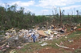
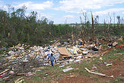
3 deaths $115 million in total damage. In Charles County, 100 homes and 49 businesses were destroyed. 638 homes and 143 businesses were damaged. 65% of the buildings in downtown La Plata were heavily damaged or destroyed. Over 100 people were injured. In Calvert County, a number of structures were damaged. | |
| F2 | La Plata La Plata, Maryland La Plata is a town in Charles County, Maryland, United States. The population was 6,551 at the 2000 census. It is the county seat of Charles County.-History:... area |
Charles Charles County, Maryland Charles County is a county in the south central portion of the U.S. state of Maryland.As of 2010, the population was 146,551. Its county seat is La Plata. This county was named for Charles Calvert , third Baron Baltimore.... |
2302 | 3 miles (4.8 km) |
A weaker tornado affected the La Plata area with unknown additional damage | |
| F1 | NE of St. Leonard St. Leonard, Maryland St. Leonard is a census-designated place in Calvert County, Maryland, United States. The population was officially 536 at the 2000 census, although residents of the Calvert Beach-Long Beach, Maryland community also use the St. Leonard zip code designation, making it in fact a much larger community... |
Calvert Calvert County, Maryland Calvert County is a county located in the U.S. state of Maryland. It occupies the Calvert Peninsula which is bordered on the east by the Chesapeake Bay and on the west by the Patuxent River. Calvert County is part of the Southern Maryland region. Calvert County's residents are among the highest... |
2342 | 5 miles (8 km) |
Unknown damage | |
| F3 | NW of Golden Hill to W of Royal Oak Royal Oak, Maryland Royal Oak is an unincorporated community in Talbot County, Maryland, United States.-References:... |
Dorchester Dorchester County, Maryland Dorchester County is a county located in the U.S. state of Maryland on its Eastern Shore. It is bordered by the Choptank River to the north, Talbot County to the northwest, Caroline County to the northeast, Wicomico County to the southeast, Sussex County, Delaware, to the east, and the Chesapeake... |
2355 | 18 miles (28.8 km) |
One house and several outbuildings destroyed | |
| F0 | SE of Wetipquin Wetipquin, Maryland Wetipquin is an unincorporated community in Wicomico County, Maryland, United States.-References:... |
Wicomico Wicomico County, Maryland As of the census of 2010, there were 98,733 people, 37,220 households, and 24,172 families residing in the county. The population density was 261.7 people per square mile . There were 41,192 housing units at an average density of 109.2 per square mile... |
0028 | 4 miles (6.4 km) |
Damage limited to trees | |
| Source: Tornado History Storm Data - April 28, 2002 |
||||||
Iowa, Kansas, Nebraska
| State | Total | County | County total |
|---|---|---|---|
| Illinois Illinois Illinois is the fifth-most populous state of the United States of America, and is often noted for being a microcosm of the entire country. With Chicago in the northeast, small industrial cities and great agricultural productivity in central and northern Illinois, and natural resources like coal,... |
1 | Union | 1 |
| Kentucky Kentucky The Commonwealth of Kentucky is a state located in the East Central United States of America. As classified by the United States Census Bureau, Kentucky is a Southern state, more specifically in the East South Central region. Kentucky is one of four U.S. states constituted as a commonwealth... |
1 | Breckinridge Breckinridge County, Kentucky As of the census of 2000, there were 18,648 people, 7,324 households, and 5,309 families residing in the county. The population density was . There were 9,890 housing units at an average density of... |
1 |
| Maryland Maryland Maryland is a U.S. state located in the Mid Atlantic region of the United States, bordering Virginia, West Virginia, and the District of Columbia to its south and west; Pennsylvania to its north; and Delaware to its east... |
3 | Calvert Calvert County, Maryland Calvert County is a county located in the U.S. state of Maryland. It occupies the Calvert Peninsula which is bordered on the east by the Chesapeake Bay and on the west by the Patuxent River. Calvert County is part of the Southern Maryland region. Calvert County's residents are among the highest... |
2 |
| Charles Charles County, Maryland Charles County is a county in the south central portion of the U.S. state of Maryland.As of 2010, the population was 146,551. Its county seat is La Plata. This county was named for Charles Calvert , third Baron Baltimore.... |
1 | ||
| Missouri Missouri Missouri is a US state located in the Midwestern United States, bordered by Iowa, Illinois, Kentucky, Tennessee, Arkansas, Oklahoma, Kansas and Nebraska. With a 2010 population of 5,988,927, Missouri is the 18th most populous state in the nation and the fifth most populous in the Midwest. It... |
1 | Bollinger Bollinger County, Missouri Bollinger County is a county located in Southeast Missouri in the United States. As of the 2010 U.S. Census, the county's population was 12,363; despite a 2009 estimate that showed the population to be 11,841. The county seat is Marble Hill, which is the only city in Bollinger County... |
1 |
| Totals | 6 | ||
| All deaths were tornado-related | |||
A total of 6 tornadoes, all rated F0 or F1 in strength (see Fujita scale
Fujita scale
The Fujita scale , or Fujita-Pearson scale, is a scale for rating tornado intensity, based primarily on the damage tornadoes inflict on human-built structures and vegetation...
) were confirmed in these states. These first reported tornadoes of the outbreak - on the afternoon of the 27th - caused little or no damage.
Missouri
3 tornadoes were reported later in the day in Missouri. An F2 tornado produced damage in Willow Springs, MO, and a large F3 tornado struck the Marble Hill, MO area in Bollinger County, MO shortly before midnight. This storm caused the first fatality of the outbreak, and produced $4 million in property damage.Illinois, Indiana, Kentucky
Tornado reports began in Illinois late on the 27th and continued overnight into the 28th. 6 tornadoes were reported in Illinois, 10 in Kentucky and 1 in Indiana. In Illinois, F3 damage was seen at Dongola, IL and Dixon Springs, IL, with over 50 homes damaged or destroyed in Dongola. F2 to F3 damage was also noted with a long track tornado that moved from Tobinsport, IN through Meade County, KY, south of Brandenburg, KentuckyBrandenburg, Kentucky
Brandenburg is a city in Meade County, Kentucky, United States, along the Ohio River. The population was 2,049 at the 2000 census. It is the county seat of Meade County.-History:...
.
Tennessee
Tennessee saw 4 tornadoes reported during the pre-dawn hours on the 28th, with a 5th tornado reported shortly after noon. The most substantial damage was seen at Murfreesboro, TN, where 31 injuries and $2.3 million in property damage was reported. The same supercellSupercell
A supercell is a thunderstorm that is characterized by the presence of a mesocyclone: a deep, continuously-rotating updraft. For this reason, these storms are sometimes referred to as rotating thunderstorms...
spawned an additional F2 tornado at Bradyville, TN.
New York, Ohio, Pennsylvania, West Virginia
Sporadic but strong tornadoes were reported in all four states on the afternoon of the 28th. A strong F2 tornado produced $45 million in damage in and around Jackson Twp., OH, and additional tornadoes (F0 to F2 in strength) were reported across southwest Pennsylvania, southwest New York, and at St. Joseph, WV. The St. Joseph supercell produced large hail a considerable time before this tornado occurred, and the parent supercell later produced the most severe weatherWeather
Weather is the state of the atmosphere, to the degree that it is hot or cold, wet or dry, calm or stormy, clear or cloudy. Most weather phenomena occur in the troposphere, just below the stratosphere. Weather refers, generally, to day-to-day temperature and precipitation activity, whereas climate...
recorded during this outbreak, after crossing into Virginia and Maryland.
Virginia, Maryland
Appalachian Mountains
The Appalachian Mountains #Whether the stressed vowel is or ,#Whether the "ch" is pronounced as a fricative or an affricate , and#Whether the final vowel is the monophthong or the diphthong .), often called the Appalachians, are a system of mountains in eastern North America. The Appalachians...
, producing numerous hail and wind damage reports. This storm spawned its second tornado (F2) in Shenandoah County, Virginia
Shenandoah County, Virginia
As of the census of 2000, there were 35,075 people, 14,296 households, and 10,064 families residing in the county. The population density was 68 people per square mile . There were 16,709 housing units at an average density of 33 per square mile...
, blowing trucks from I-81. Shortly thereafter, funnel clouds were reported with the same storm in Fauquier County, Virginia
Fauquier County, Virginia
As of the census of 2000, there were 55,139 people, 19,842 households, and 15,139 families residing in the county. The population density was 85 people per square mile . There were 21,046 housing units at an average density of 32 per square mile...
and Prince William County, Virginia
Prince William County, Virginia
-National protected areas:* Featherstone National Wildlife Refuge* Manassas National Battlefield Park* Occoquan Bay National Wildlife Refuge* Prince William Forest Park-Government and politics:...
(at the southern edge of the metro Washington, D.C.
Washington, D.C.
Washington, D.C., formally the District of Columbia and commonly referred to as Washington, "the District", or simply D.C., is the capital of the United States. On July 16, 1790, the United States Congress approved the creation of a permanent national capital as permitted by the U.S. Constitution....
area). Crossing the Potomac River
Potomac River
The Potomac River flows into the Chesapeake Bay, located along the mid-Atlantic coast of the United States. The river is approximately long, with a drainage area of about 14,700 square miles...
into Maryland, the storm then spawned a series of powerful (F2, F3 and F4) tornadoes that moved along a nearly continual path starting south of Indian Head, Maryland
Indian Head, Maryland
Indian Head is a town in Charles County, Maryland, United States. The population was 3,422 at the 2000 census. It has been the site of a naval base specializing in gun and rocket propellants since 1890. Production of nitrocellulose and smokeless powder began at the Indian Head Powder Factory in 1900...
and continuing into La Plata, Maryland
La Plata, Maryland
La Plata is a town in Charles County, Maryland, United States. The population was 6,551 at the 2000 census. It is the county seat of Charles County.-History:...
, devastating La Plata's business district. Damage surveys revealed this tornado to be an F4, though a preliminary NWS survey first categorized it as an F5.
Continuing east, damage fluctuated between F2 and F4 levels through eastern Charles County, Maryland
Charles County, Maryland
Charles County is a county in the south central portion of the U.S. state of Maryland.As of 2010, the population was 146,551. Its county seat is La Plata. This county was named for Charles Calvert , third Baron Baltimore....
and southern Calvert County, Maryland
Calvert County, Maryland
Calvert County is a county located in the U.S. state of Maryland. It occupies the Calvert Peninsula which is bordered on the east by the Chesapeake Bay and on the west by the Patuxent River. Calvert County is part of the Southern Maryland region. Calvert County's residents are among the highest...
. The tornado or tornadoes made a 10 mile crossing of the Chesapeake Bay
Chesapeake Bay
The Chesapeake Bay is the largest estuary in the United States. It lies off the Atlantic Ocean, surrounded by Maryland and Virginia. The Chesapeake Bay's drainage basin covers in the District of Columbia and parts of six states: New York, Pennsylvania, Delaware, Maryland, Virginia, and West...
and emerged on the Eastern Shore
Eastern Shore of Maryland
The Eastern Shore of Maryland is a territorial part of the U.S. state of Maryland that lies predominately on the east side of the Chesapeake Bay and consists of nine counties. The origin of term Eastern Shore was derived to distinguish a territorial part of the State of Maryland from the Western...
in Dorchester County, Maryland
Dorchester County, Maryland
Dorchester County is a county located in the U.S. state of Maryland on its Eastern Shore. It is bordered by the Choptank River to the north, Talbot County to the northwest, Caroline County to the northeast, Wicomico County to the southeast, Sussex County, Delaware, to the east, and the Chesapeake...
. Now weakened to consistent F2 strength (still with brief F3 bursts), the storm dissipated several miles west of Salisbury, Maryland
Salisbury, Maryland
-Demographics:Salisbury is the principal city of the Salisbury-Ocean Pines CSA, a Combined Statistical Area that includes the Salisbury metropolitan area and the Ocean Pines micropolitan area , which had a combined population of 176,657 at the 2010 census.As of the census of 2000, there were...
. This storm produced debris fallout 66 miles away, at Federalsburg, Maryland
Federalsburg, Maryland
Federalsburg is a town in Caroline County, Maryland, United States. The population was 2,642 at the 2009 census. The ZIP code is 21632. The primary phone exchange is 754 and the area code is 410.-Town features:...
, and also in southern Delaware
Delaware
Delaware is a U.S. state located on the Atlantic Coast in the Mid-Atlantic region of the United States. It is bordered to the south and west by Maryland, and to the north by Pennsylvania...
, and hail up to 4.5 inches in diameter was reported in northern Charles County.
Farther south, tornadoes also produced damage in the City of Bedford, Virginia
Bedford, Virginia
Bedford is an independent city located within the confines of Bedford County in the U.S. state of Virginia. It serves as the county seat of Bedford County. As of 2010, the city had a total population of 6,222. The Bureau of Economic Analysis combines the city of Bedford with surrounding Bedford...
(west of Lynchburg
Lynchburg, Virginia
Lynchburg is an independent city in the Commonwealth of Virginia. The population was 75,568 as of 2010. Located in the foothills of the Blue Ridge Mountains along the banks of the James River, Lynchburg is known as the "City of Seven Hills" or "The Hill City." Lynchburg was the only major city in...
), and near Emporia, Virginia
Emporia, Virginia
Emporia is an independent city located within the confines of Greensville County, Virginia, United States. The population was estimated to be 5,927 in 2010. The Bureau of Economic Analysis combines the city of Emporia with surrounding Greensville county for statistical purposes...
, along I-95
Interstate 95 in Virginia
In the Commonwealth of Virginia, Interstate 95 runs through the state. It runs concurrently for with Interstate 64 in Richmond, and meets the northern terminus of Interstate 85 in Petersburg. Though Interstate 95 was originally planned to go straight through Washington, D.C., it was instead...
just north of the North Carolina
North Carolina
North Carolina is a state located in the southeastern United States. The state borders South Carolina and Georgia to the south, Tennessee to the west and Virginia to the north. North Carolina contains 100 counties. Its capital is Raleigh, and its largest city is Charlotte...
state line.
Much of La Plata had previously been destroyed by an F4 tornado on November 9, 1926.
A total of $125 million in damage, 4 fatalities and 122 injuries were directly caused by the Maryland storms (the most expensive in the history of the state). Another $8 million in damage, along with 17 injuries were reported in Virginia.
External links
- NWS Service Assessment
- April 2002 Tornadoes (NWS Paducah)
- Storm Survey in Rutherford County (NWS Nashville, TN)
- Satellite imagery (University of Wisconsin–MadisonUniversity of Wisconsin–MadisonThe University of Wisconsin–Madison is a public research university located in Madison, Wisconsin, United States. Founded in 1848, UW–Madison is the flagship campus of the University of Wisconsin System. It became a land-grant institution in 1866...
)