

Mid Cheshire Ridge
Encyclopedia
Sandstone
Sandstone is a sedimentary rock composed mainly of sand-sized minerals or rock grains.Most sandstone is composed of quartz and/or feldspar because these are the most common minerals in the Earth's crust. Like sand, sandstone may be any colour, but the most common colours are tan, brown, yellow,...
hills which stretch north to south through Cheshire
Cheshire
Cheshire is a ceremonial county in North West England. Cheshire's county town is the city of Chester, although its largest town is Warrington. Other major towns include Widnes, Congleton, Crewe, Ellesmere Port, Runcorn, Macclesfield, Winsford, Northwich, and Wilmslow...
in North West England
North West England
North West England, informally known as The North West, is one of the nine official regions of England.North West England had a 2006 estimated population of 6,853,201 the third most populated region after London and the South East...
. The ridge is discontinuous, with the hills forming two main blocks, north and south of the "Beeston Gap". The main mass of those to the south are known as the Peckforton Hills
Peckforton Hills
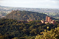
The Peckforton Hills are a sandstone ridge running broadly northeast–southwest in the west of the English county of Cheshire. They form a significant part of the longer Mid Cheshire Ridge which extends southwards from Frodsham towards Malpas....
; the larger group of hills to the north do not have a collective name.
Significant summits
Peckforton Hills
The Peckforton Hills are a sandstone ridge running broadly northeast–southwest in the west of the English county of Cheshire. They form a significant part of the longer Mid Cheshire Ridge which extends southwards from Frodsham towards Malpas....
, some 227 m above sea level. Other significant summits are, from north to south:
- Beacon Hill (150 m), 53.2846°N 2.7222°W (FrodshamFrodshamFrodsham is a market town and civil parish in the unitary authority of Cheshire West and Chester and the ceremonial county of Cheshire, England. Its population is 8,982. It is approximately south of Runcorn, 16 miles south of Liverpool, and approximately south-west of Manchester...
) - Woodhouse Hill (145 m), 53.2763°N 2.7352°W (FrodshamFrodshamFrodsham is a market town and civil parish in the unitary authority of Cheshire West and Chester and the ceremonial county of Cheshire, England. Its population is 8,982. It is approximately south of Runcorn, 16 miles south of Liverpool, and approximately south-west of Manchester...
) - Helsby Hill (140 m), 53.2737°N 2.7635°W (HelsbyHelsbyHelsby is a large village and civil parish in the unitary authority of Cheshire West and Chester and the ceremonial county of Cheshire, England. At the 2001 Census, Helsby had a population of 4,701.-Geography:...
) - Alvanley Cliff (135 m), 53.2597°N 2.7356°W (AlvanleyAlvanleyright|thumb|200px|Map of civil parish of Alvanley within the former borough of [[Vale Royal]].Alvanley is a small rural village and civil parish near the village of Helsby, in the unitary authority of Cheshire West and Chester and the ceremonial county of Cheshire, England...
) - Birch Hill (158 m), 53.2591°N 2.7180°W (ManleyManley, Cheshireright|thumb|200px|Map of civil parish of Manley within the former borough of Vale RoyalManley is a village and civil parish in the unitary authority of Cheshire West and Chester and the ceremonial county of Cheshire, in the north west of England.-External links:...
) - Old Pale (176 m), 53.2217°N 2.6854°W (DelamereDelamere, Cheshirethumb|right|200px|Map of civil parish of Delamere within the former borough of Vale RoyalDelamere is a civil parish and village in Cheshire. It is situated approximately 7 miles to the west of Northwich, within the unitary authority of Cheshire West and Chester.The village is well-known for the...
) - Eddisbury Hill (158 m), 53.2200°N 2.6720°W (DelamereDelamere, Cheshirethumb|right|200px|Map of civil parish of Delamere within the former borough of Vale RoyalDelamere is a civil parish and village in Cheshire. It is situated approximately 7 miles to the west of Northwich, within the unitary authority of Cheshire West and Chester.The village is well-known for the...
) - Primrosehill (158 m), 53.2083°N 2.6955°W (DelamereDelamere, Cheshirethumb|right|200px|Map of civil parish of Delamere within the former borough of Vale RoyalDelamere is a civil parish and village in Cheshire. It is situated approximately 7 miles to the west of Northwich, within the unitary authority of Cheshire West and Chester.The village is well-known for the...
) - High Billinge (175 m), 53.1910°N 2.6679°W (UtkintonUtkintonthumb|200px|Map of civil parish of Utkinton within the former borough of Vale RoyalUtkinton is a civil parish and small village in the unitary authority of Cheshire West and Chester and the ceremonial county of Cheshire, England. It is approximately 8 miles west of Winsford and north of Tarporley...
) - Luddington Hill (145 m), 53.1766°N 2.6522°W (UtkintonUtkintonthumb|200px|Map of civil parish of Utkinton within the former borough of Vale RoyalUtkinton is a civil parish and small village in the unitary authority of Cheshire West and Chester and the ceremonial county of Cheshire, England. It is approximately 8 miles west of Winsford and north of Tarporley...
)- (Beeston Gap)
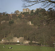
- Beeston Castle Hill (155 m), 53.1288°N 2.6935°W (BeestonBeeston, CheshireBeeston is a village and civil parish in the unitary authority of Cheshire West and Chester and the ceremonial county of Cheshire in the north of England. It is south of Tarporley, and close to the Shropshire Union Canal. Beeston Castle nearby is a spectacular clifftop ruin in the care of English...
) - Stanner Nab (200 m), 53.1109°N 2.7016°W (PeckfortonPeckfortonPeckforton is a scattered settlement and civil parish in the unitary authority of Cheshire East and the ceremonial county of Cheshire, England. The settlement is located to the north east of Malpas and miles to the west of Nantwich. The total population of the civil parish is somewhat over 100...
) - Peckforton Hill (203 m), 53.0968°N 2.7028°W (PeckfortonPeckfortonPeckforton is a scattered settlement and civil parish in the unitary authority of Cheshire East and the ceremonial county of Cheshire, England. The settlement is located to the north east of Malpas and miles to the west of Nantwich. The total population of the civil parish is somewhat over 100...
) - Burwardsley Hill (186 m), 53.0952°N 2.7092°W (BurwardsleyBurwardsleyBurwardsley is a village and civil parish the unitary authority of Cheshire West and Chester and the ceremonial county of Cheshire, England. The parish also includes the small villages of Burwardsley, Burwardsley Hill, Higher Burwardsley. The parish also includes Burwardsley Hall and is part of...
) - Bulkeley Hill (220 m), 53.0925°N 2.7077°W (BulkeleyBulkeleyBulkeley is a village and civil parish in the unitary authority of Cheshire East and the ceremonial county of Cheshire, England. The village is situated at on the A534 about 9 miles west of Nantwich. The civil parish also includes the small settlement of Bulkelehay at , with a total population...
) - Bickerton HillBickerton HillBickerton Hill refers to two low red sandstone hills that form the southern end of the Mid Cheshire Ridge in Cheshire, north-west England. The high point, Raw Head, lies on the northerly hill and has an elevation of 227 metres...
(Raw Head) (227 m), 53.0763°N 2.7441°W (BickertonBickerton, CheshireBickerton is a village and civil parish in the unitary authority of Cheshire East and the ceremonial county of Cheshire, England, about eight miles north of Whitchurch in Shropshire. The parish also includes the small settlement of Gallantry Bank, with a total population of over 200...
and HarthillHarthill, CheshireHarthill is a village and civil parish in the unitary authority of Cheshire West and Chester and the ceremonial county of Cheshire, England.All Saints Church, Harthill is a Grade II* listed building.-External links:...
) - Bickerton Hill (south) (193 m), 53.0756°N 2.7459°W (BickertonBickerton, CheshireBickerton is a village and civil parish in the unitary authority of Cheshire East and the ceremonial county of Cheshire, England, about eight miles north of Whitchurch in Shropshire. The parish also includes the small settlement of Gallantry Bank, with a total population of over 200...
) - Maiden Castle (210 m), 53.0709°N 2.7512°W (BickertonBickerton, CheshireBickerton is a village and civil parish in the unitary authority of Cheshire East and the ceremonial county of Cheshire, England, about eight miles north of Whitchurch in Shropshire. The parish also includes the small settlement of Gallantry Bank, with a total population of over 200...
& DuckingtonDuckingtonDuckington is a small village and civil parish in the unitary authority of Cheshire West and Chester and the ceremonial county of Cheshire, England.-External links:...
)
Geology
The hills are composed of a range of sandstoneSandstone
Sandstone is a sedimentary rock composed mainly of sand-sized minerals or rock grains.Most sandstone is composed of quartz and/or feldspar because these are the most common minerals in the Earth's crust. Like sand, sandstone may be any colour, but the most common colours are tan, brown, yellow,...
s of Permian
Permian
The PermianThe term "Permian" was introduced into geology in 1841 by Sir Sir R. I. Murchison, president of the Geological Society of London, who identified typical strata in extensive Russian explorations undertaken with Edouard de Verneuil; Murchison asserted in 1841 that he named his "Permian...
and Triassic
Triassic
The Triassic is a geologic period and system that extends from about 250 to 200 Mya . As the first period of the Mesozoic Era, the Triassic follows the Permian and is followed by the Jurassic. Both the start and end of the Triassic are marked by major extinction events...
age. North–south faulting is in part responsible for elevating harder-wearing strata above the general level of the Cheshire Plain
Cheshire Plain
The Cheshire Plain is a relatively flat expanse of lowland situated almost entirely within the county of Cheshire in northwest England. It is bounded by the hills of North Wales to the west, and the Peak District of Derbyshire and North Staffordshire to the east and southeast...
. Typically the higher summits are formed from the Helsby Sandstone.
The ridge acted as something of a barrier to the passage of Irish Sea
Irish Sea
The Irish Sea separates the islands of Ireland and Great Britain. It is connected to the Celtic Sea in the south by St George's Channel, and to the Atlantic Ocean in the north by the North Channel. Anglesey is the largest island within the Irish Sea, followed by the Isle of Man...
ice during the last ice age
Ice age
An ice age or, more precisely, glacial age, is a generic geological period of long-term reduction in the temperature of the Earth's surface and atmosphere, resulting in the presence or expansion of continental ice sheets, polar ice sheets and alpine glaciers...
and its hills are etched with numerous glacial meltwater channels
Subglacial channel
A subglacial meltwater channel is a channel beneath an ice mass, like ice sheets and valley glaciers, roughly parallel to the main ice direction. These meltwater channels can have different sizes, ranging from very small channels of a metre deep and wide to big valleys which can be up to a...
, many of which formed subglacially. Particularly spectacular examples are those at Urchin's Kitchen in Primrosehill Woods and at Holbitch Slack near Cotebrook.
Hill forts
A series of Iron AgeIron Age
The Iron Age is the archaeological period generally occurring after the Bronze Age, marked by the prevalent use of iron. The early period of the age is characterized by the widespread use of iron or steel. The adoption of such material coincided with other changes in society, including differing...
hill fort
Hill fort
A hill fort is a type of earthworks used as a fortified refuge or defended settlement, located to exploit a rise in elevation for defensive advantage. They are typically European and of the Bronze and Iron Ages. Some were used in the post-Roman period...
s adorn the ridge from Woodhouse Hill and Helsby Hill in the north through Eddisbury
Eddisbury hill fort
Eddisbury hill fort, also known as Castle Ditch, is an Iron Age hill fort near Delamere, Cheshire, in northern England. Hill forts are fortified hill-top settlements constructed across Britain during the Iron Age. Eddisbury is the largest and most complex of the seven hill forts in the county of...
and Kelsborrow Castle
Kelsborrow Castle
Kelsborrow Castle is an Iron Age hill fort. Hill forts were fortified hill-top settlements constructed across Britain during the Iron Age. It is one of only seven hill forts in the county of Cheshire in northern England and was probably in use for only a short time. In the 19th century, a bronze...
to Maiden Castle
Maiden Castle, Cheshire
Maiden Castle is an Iron Age hill fort, one of many fortified hill-top settlements constructed across Britain during the Iron Age, but one of only seven in the county of Cheshire in northern England. The hill fort was probably occupied from its construction in 600 BC until the Roman conquest...
in the south.
Recreation
The ridge is traversed by the popular Sandstone TrailSandstone Trail
The Sandstone Trail is a long-distance walkers' path, following sandstone ridges running north–south from Frodsham in central Cheshire to Whitchurch just over the Shropshire border. The path was created in 1974 and extended in the 1990s...
, a middle-distance recreational route
Long-distance trail
Long-distance trails are the longer recreational trails mainly through rural areas, used for non-motorised recreational travelling ....
originally established by the former Cheshire County Council
Cheshire County Council
Cheshire County Council was a County Council, of the second highest level of United Kingdom Government for the residents of Cheshire. Founded in 1889, it ceased to exist on 1 April 2009, when it and the district councils in Cheshire were replaced by two unitary authorities; Cheshire West and...
between Beacon Hill and Grindley Brook on the Shropshire
Shropshire
Shropshire is a county in the West Midlands region of England. For Eurostat purposes, the county is a NUTS 3 region and is one of four counties or unitary districts that comprise the "Shropshire and Staffordshire" NUTS 2 region. It borders Wales to the west...
border but now extended into Frodsham
Frodsham
Frodsham is a market town and civil parish in the unitary authority of Cheshire West and Chester and the ceremonial county of Cheshire, England. Its population is 8,982. It is approximately south of Runcorn, 16 miles south of Liverpool, and approximately south-west of Manchester...
to the north and Whitchurch
Whitchurch, Shropshire
Whitchurch is a market town in Shropshire, England on the border between England and Wales. It is the oldest continuously inhabited town in Shropshire. According to the 2001 Census, the population of the town is 8,673, with a more recent estimate putting the population of the town at 8,934...
to the south. Sections of the Delamere Way
Delamere Way
The Delamere Way is a footpath running from Frodsham to Stockton Heath within the English county of Cheshire. The total length of the trail is .-The route:...
, Longster Trail
Longster Trail
The Longster Trail is a waymarked footpath in the United Kingdom. It runs 9.1 miles/15 kilometers from the summit of Helsby Hill, Helsby, to the village of Pipers Ash, Chester passing through Alvanley, Barrow and Guilden Sutton...
and Eddisbury Way
Eddisbury Way
The Eddisbury Way is a footpath running from Frodsham to Higher Burwardsley within the English county of Cheshire. The total length of the trail is . The path is waymarked with yellow arrows containing the words Eddisbury Way.-The route:...
also explore parts of the ridge.
Numerous of the woods along the ridge have been used for orienteering
Orienteering
Orienteering is a family of sports that requires navigational skills using a map and compass to navigate from point to point in diverse and usually unfamiliar terrain, and normally moving at speed. Participants are given a topographical map, usually a specially prepared orienteering map, which they...
competitions over the years. Horseriding is also popular in the area, as it is traversed by a number of bridleways, byways and green lanes.