
Sandstone Trail
Encyclopedia
The Sandstone Trail is a 55 kilometres (34.2 mi) long-distance walkers' path, following sandstone
ridges running north–south from Frodsham
in central Cheshire
to Whitchurch
just over the Shropshire
border. The path was created in 1974 and extended in the 1990s. Much of the route follows the Mid Cheshire Ridge
but in places the trail also passes through the Cheshire Plain
, including farmland, woodland and canal towpaths.
to Willington
, the central section covers Willington to Bickerton
, and the southern part is from Bickerton to Whitchurch
. shropshire union canal.
 These stones are at:
The ends of the trail are also marked with a sandstone obelisk
outside the Bears Paw Public House at Frodsham, and a 2m high sandstone archway at the entrance of the car park at Jubilee Park, Whitchurch.
 Points of interest travelling from Frodsham
to Whitchurch
(north–south) include:
On the clearest of days sights such as the Liver Building and Anglican Cathedral in Liverpool
and the Shell Stanlow Oil Refinery at Ellesmere Port
can be seen from many different locations including Bickerton Hill. Other famous landmarks visible from the trail include the Jodrell Bank Observatory, which can be seen from Bulkeley Hill.
, climbs to the ridge's high point at Raw Head (227 metres) and runs northwards to Barnes Bridge Gates in Delamere Forest
. The shorter race (17 kilometres (10.6 mi), 288 metres (944.9 ft) of climbing) starts near Beeston Castle
, finishing in the same place.
For many years the Fire Service organised a full traverse of the trail in a day, enjoyed by walkers and runners. In May 2011 the event was revived by Helsby Running Club as an LDWA event. The current record for the full traverse is held by Adair Broughton of Helsby RC, in 4 hours, 33 minutes.
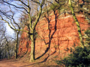
Sandstone
Sandstone is a sedimentary rock composed mainly of sand-sized minerals or rock grains.Most sandstone is composed of quartz and/or feldspar because these are the most common minerals in the Earth's crust. Like sand, sandstone may be any colour, but the most common colours are tan, brown, yellow,...
ridges running north–south from Frodsham
Frodsham
Frodsham is a market town and civil parish in the unitary authority of Cheshire West and Chester and the ceremonial county of Cheshire, England. Its population is 8,982. It is approximately south of Runcorn, 16 miles south of Liverpool, and approximately south-west of Manchester...
in central Cheshire
Cheshire
Cheshire is a ceremonial county in North West England. Cheshire's county town is the city of Chester, although its largest town is Warrington. Other major towns include Widnes, Congleton, Crewe, Ellesmere Port, Runcorn, Macclesfield, Winsford, Northwich, and Wilmslow...
to Whitchurch
Whitchurch, Shropshire
Whitchurch is a market town in Shropshire, England on the border between England and Wales. It is the oldest continuously inhabited town in Shropshire. According to the 2001 Census, the population of the town is 8,673, with a more recent estimate putting the population of the town at 8,934...
just over the Shropshire
Shropshire
Shropshire is a county in the West Midlands region of England. For Eurostat purposes, the county is a NUTS 3 region and is one of four counties or unitary districts that comprise the "Shropshire and Staffordshire" NUTS 2 region. It borders Wales to the west...
border. The path was created in 1974 and extended in the 1990s. Much of the route follows the Mid Cheshire Ridge
Mid Cheshire Ridge
The Mid Cheshire Ridge is a range of low sandstone hills which stretch north to south through Cheshire in North West England. The ridge is discontinuous, with the hills forming two main blocks, north and south of the "Beeston Gap"...
but in places the trail also passes through the Cheshire Plain
Cheshire Plain
The Cheshire Plain is a relatively flat expanse of lowland situated almost entirely within the county of Cheshire in northwest England. It is bounded by the hills of North Wales to the west, and the Peak District of Derbyshire and North Staffordshire to the east and southeast...
, including farmland, woodland and canal towpaths.
Route
The trail is divided into three sections of about 18 km (11.3 mi) in length: the northern portion runs from FrodshamFrodsham
Frodsham is a market town and civil parish in the unitary authority of Cheshire West and Chester and the ceremonial county of Cheshire, England. Its population is 8,982. It is approximately south of Runcorn, 16 miles south of Liverpool, and approximately south-west of Manchester...
to Willington
Willington, Cheshire
Willington is a village and civil parish, about from Chester, in the unitary authority of Cheshire West and Chester and the ceremonial county of Cheshire, England....
, the central section covers Willington to Bickerton
Bickerton, Cheshire
Bickerton is a village and civil parish in the unitary authority of Cheshire East and the ceremonial county of Cheshire, England, about eight miles north of Whitchurch in Shropshire. The parish also includes the small settlement of Gallantry Bank, with a total population of over 200...
, and the southern part is from Bickerton to Whitchurch
Whitchurch, Shropshire
Whitchurch is a market town in Shropshire, England on the border between England and Wales. It is the oldest continuously inhabited town in Shropshire. According to the 2001 Census, the population of the town is 8,673, with a more recent estimate putting the population of the town at 8,934...
. shropshire union canal.
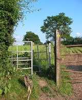
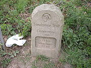
Information and waymarking
The trail is marked with signposts and yellow discs inscribed with an 'S' in a footprint. Stone distance markers and blue information boards are also located at intervals, usually before or entering a new area of the trail. The information boards generally give details of local history while the stones give the distance in kilometres to the ends of the trail at Frodsham and Whitchurch.- Ridgeway Wood, Helsby (5 km to Frodsham, 50 km to Whitchurch)
- Manley Common, New Pale Road, Manley (9 km to Frodsham, 46 km to Whitchurch)
- Barnsbridge Gates, Ashton Road, Delamere Forest (12 km to Frodsham, 43 km to Whitchurch)
- Willington Road, Willington (18 km to Frodsham, 37 km to Whitchurch)
- Wharton's Lock (26 km to Frodsham, 29 km to Whitchurch)
- Coppermine Lane, in between Rawhead and Bulkeley Hill (33 km to Frodsham, 22 km to Whitchurch)
- Bickerton (37 km to Frodsham, 18 km to Whitchurch)
- Bickleywood (45 km to Frodsham, 10 km to Whitchurch)
- Grindley Brook (51 km to Frodsham, 4 km to Whitchurch)
The ends of the trail are also marked with a sandstone obelisk
Obelisk
An obelisk is a tall, four-sided, narrow tapering monument which ends in a pyramid-like shape at the top, and is said to resemble a petrified ray of the sun-disk. A pair of obelisks usually stood in front of a pylon...
outside the Bears Paw Public House at Frodsham, and a 2m high sandstone archway at the entrance of the car park at Jubilee Park, Whitchurch.
Sights
Frodsham
Frodsham is a market town and civil parish in the unitary authority of Cheshire West and Chester and the ceremonial county of Cheshire, England. Its population is 8,982. It is approximately south of Runcorn, 16 miles south of Liverpool, and approximately south-west of Manchester...
to Whitchurch
Whitchurch, Shropshire
Whitchurch is a market town in Shropshire, England on the border between England and Wales. It is the oldest continuously inhabited town in Shropshire. According to the 2001 Census, the population of the town is 8,673, with a more recent estimate putting the population of the town at 8,934...
(north–south) include:
- Woodhouse Hill Fort, an Iron Age fort
- Alvanley Cliffs
- Delamere ForestDelamere ForestDelamere Forest or Delamere Forest Park is a wood in the Cheshire West and Chester area of Cheshire, England, near the town of Frodsham. It includes of mixed deciduous and evergreen woodland, centred at around , making it the largest area of woodland in Cheshire...
and Eddisbury Hill - Beeston CastleBeeston CastleBeeston Castle is a former Royal castle in Beeston, Cheshire, England , perched on a rocky sandstone crag above the Cheshire Plain. It was built in the 1220s by Ranulf de Blondeville, 6th Earl of Chester, , on his return from the Crusades...
- Peckforton CastlePeckforton CastlePeckforton Castle is a country house built in the style of a medieval castle. It stands in woodland at the north end of Peckforton Hills northwest of the village of Peckforton, Cheshire, England. It has been designated by English Heritage as a Grade I listed building...
in the Peckforton HillsPeckforton HillsThe Peckforton Hills are a sandstone ridge running broadly northeast–southwest in the west of the English county of Cheshire. They form a significant part of the longer Mid Cheshire Ridge which extends southwards from Frodsham towards Malpas.... - Burwardsley villageBurwardsleyBurwardsley is a village and civil parish the unitary authority of Cheshire West and Chester and the ceremonial county of Cheshire, England. The parish also includes the small villages of Burwardsley, Burwardsley Hill, Higher Burwardsley. The parish also includes Burwardsley Hall and is part of...
- Bickerton HillBickerton HillBickerton Hill refers to two low red sandstone hills that form the southern end of the Mid Cheshire Ridge in Cheshire, north-west England. The high point, Raw Head, lies on the northerly hill and has an elevation of 227 metres...
s and Maiden CastleMaiden Castle, CheshireMaiden Castle is an Iron Age hill fort, one of many fortified hill-top settlements constructed across Britain during the Iron Age, but one of only seven in the county of Cheshire in northern England. The hill fort was probably occupied from its construction in 600 BC until the Roman conquest...
, an Iron Age fort - Wharton's & Willeymoor locks on the Shropshire Union CanalShropshire Union CanalThe Shropshire Union Canal is a navigable canal in England; the Llangollen and Montgomery canals are the modern names of branches of the Shropshire Union system and lie partially in Wales....
- Grindley BrookGrindley BrookGrindley Brook is a small village in Shropshire, England, on the A41 trunk road around 1.5 miles north west of the market town of Whitchurch. It is the most northerly settlement in Shropshire and borders directly onto Cheshire, and is within the civil parish of Whitchurch Rural.It is also the name...
, staircase lock on the Llangollen branchLlangollen CanalThe Llangollen Canal is a navigable canal crossing the border between England and Wales. The waterway links Llangollen in Denbighshire, north Wales, with Hurleston in south Cheshire, via the town of Ellesmere, Shropshire....
of the Shropshire Union CanalShropshire Union CanalThe Shropshire Union Canal is a navigable canal in England; the Llangollen and Montgomery canals are the modern names of branches of the Shropshire Union system and lie partially in Wales....
On the clearest of days sights such as the Liver Building and Anglican Cathedral in Liverpool
Liverpool
Liverpool is a city and metropolitan borough of Merseyside, England, along the eastern side of the Mersey Estuary. It was founded as a borough in 1207 and was granted city status in 1880...
and the Shell Stanlow Oil Refinery at Ellesmere Port
Ellesmere Port
Ellesmere Port is a large industrial town and port in the unitary authority of Cheshire West and Chester and the ceremonial county of Cheshire, England. It is situated on the south border of the Wirral Peninsula on the banks of the Manchester Ship Canal, which in turn gives access to the River...
can be seen from many different locations including Bickerton Hill. Other famous landmarks visible from the trail include the Jodrell Bank Observatory, which can be seen from Bulkeley Hill.
Races
Part of the path is used for the Sandstone Trail Races in early October organised by Deeside Orienteering Club; the longer race has been run since 1977. The longer race (27.5 kilometres (17.1 mi), 655 metres (2,149 ft) of climbing) starts from DuckingtonDuckington
Duckington is a small village and civil parish in the unitary authority of Cheshire West and Chester and the ceremonial county of Cheshire, England.-External links:...
, climbs to the ridge's high point at Raw Head (227 metres) and runs northwards to Barnes Bridge Gates in Delamere Forest
Delamere Forest
Delamere Forest or Delamere Forest Park is a wood in the Cheshire West and Chester area of Cheshire, England, near the town of Frodsham. It includes of mixed deciduous and evergreen woodland, centred at around , making it the largest area of woodland in Cheshire...
. The shorter race (17 kilometres (10.6 mi), 288 metres (944.9 ft) of climbing) starts near Beeston Castle
Beeston Castle
Beeston Castle is a former Royal castle in Beeston, Cheshire, England , perched on a rocky sandstone crag above the Cheshire Plain. It was built in the 1220s by Ranulf de Blondeville, 6th Earl of Chester, , on his return from the Crusades...
, finishing in the same place.
For many years the Fire Service organised a full traverse of the trail in a day, enjoyed by walkers and runners. In May 2011 the event was revived by Helsby Running Club as an LDWA event. The current record for the full traverse is held by Adair Broughton of Helsby RC, in 4 hours, 33 minutes.
External links
- Cheshire West and Chester Council - Sandstone Trail
- Walking Cheshire's Sandstone Trail
- Discovercheshire website (Sandstone Trail).