
Mickle Fell
Encyclopedia
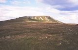
Mickle Fell is a mountain
in the Pennines
, the range of hill
s and moor
s running down the middle of Northern England
. It is 788 m (2,585 ft) high and lies slightly off the main watershed
of the Pennines, about ten miles south of Cross Fell
.
It is the highest point of both the ceremonial county
of County Durham
and the historic county
of Yorkshire
,Whernside
is the highest point within the boundaries of the ceremonial county of North Yorkshire
. lying in the southern part of Teesdale
which was transferred from the North Riding of Yorkshire
to County Durham under the Local Government Act 1972
.
The name of Mickle Fell comes from the Old Norse
word Mikill meaning Great and Fell (or fjäll) meaning mountain or hill.
The fell lies in the middle of a large area of boggy moor
and requires a long hike
to get to it from any direction. Mickle Fell's distinctive outline makes it a recognisable object in views from the Lake District
hills, particularly Blencathra
, the Helvellyn range
and High Street
. South of Mickle Fell the ridge descends to the Stainmore Gap before rising again into the Yorkshire Dales
.
Mickle Fell and surrounding moorland forms part of the Warcop Training Area, a Ministry of Defence
firing range. As a result, access to the fell is limited. It can be ascended from the Eden Valley
to the west, or from Teesdale
to the east.
Marilyn
s are scarce in the North Pennines because of the relative flatness of the moors, but Mickle Fell is one such hill: it is separated from its neighbours by over 200 m of relative height.
side, similar in form to an elongated crater
. A waterfall
at the head of the Cup is called High Cup Nick. The feature is well seen from the A66 road
. The Pennine Way
goes past High Cup on its cross-watershed trek from Middleton-in-Teesdale
to Dufton
.
Mountain
Image:Himalaya_annotated.jpg|thumb|right|The Himalayan mountain range with Mount Everestrect 58 14 160 49 Chomo Lonzorect 200 28 335 52 Makalurect 378 24 566 45 Mount Everestrect 188 581 920 656 Tibetan Plateaurect 250 406 340 427 Rong River...
in the Pennines
Pennines
The Pennines are a low-rising mountain range, separating the North West of England from Yorkshire and the North East.Often described as the "backbone of England", they form a more-or-less continuous range stretching from the Peak District in Derbyshire, around the northern and eastern edges of...
, the range of hill
Hill
A hill is a landform that extends above the surrounding terrain. Hills often have a distinct summit, although in areas with scarp/dip topography a hill may refer to a particular section of flat terrain without a massive summit A hill is a landform that extends above the surrounding terrain. Hills...
s and moor
Moor
-Ethnicity:*Moors, several historic and modern populations from North Africa*Sri Lankan Moor, a minority ethnic group of Sri Lanka*Marakkar, a Muslim minority ethnic group of India-Places:...
s running down the middle of Northern England
Northern England
Northern England, also known as the North of England, the North or the North Country, is a cultural region of England. It is not an official government region, but rather an informal amalgamation of counties. The southern extent of the region is roughly the River Trent, while the North is bordered...
. It is 788 m (2,585 ft) high and lies slightly off the main watershed
Water divide
A drainage divide, water divide, divide or watershed is the line separating neighbouring drainage basins...
of the Pennines, about ten miles south of Cross Fell
Cross Fell
Cross Fell is the highest point in the Pennine Hills of northern England and the highest point in England outside of the Lake District.The summit, at , is a stony plateau, part of a long ridge running North West to South East, which also incorporates Little Dun Fell at and Great Dun Fell at...
.
It is the highest point of both the ceremonial county
Ceremonial counties of England
The ceremonial counties are areas of England to which are appointed a Lord Lieutenant, and are defined by the government as counties and areas for the purposes of the Lieutenancies Act 1997 with reference to the metropolitan and non-metropolitan counties of England and Lieutenancies Act 1997...
of County Durham
County Durham
County Durham is a ceremonial county and unitary district in north east England. The county town is Durham. The largest settlement in the ceremonial county is the town of Darlington...
and the historic county
Historic counties of England
The historic counties of England are subdivisions of England established for administration by the Normans and in most cases based on earlier Anglo-Saxon kingdoms and shires...
of Yorkshire
Yorkshire
Yorkshire is a historic county of northern England and the largest in the United Kingdom. Because of its great size in comparison to other English counties, functions have been increasingly undertaken over time by its subdivisions, which have also been subject to periodic reform...
,Whernside
Whernside
Whernside is a mountain in the Yorkshire Dales and is one of the Yorkshire Three Peaks, the other two being Ingleborough and Pen-y-ghent. It is the highest point in the ceremonial county of North Yorkshire,Mickle Fell in southern Teesdale is the highest point within the boundaries of the historic...
is the highest point within the boundaries of the ceremonial county of North Yorkshire
North Yorkshire
North Yorkshire is a non-metropolitan or shire county located in the Yorkshire and the Humber region of England, and a ceremonial county primarily in that region but partly in North East England. Created in 1974 by the Local Government Act 1972 it covers an area of , making it the largest...
. lying in the southern part of Teesdale
Teesdale
Teesdale is a dale, or valley, of the east side of the Pennines in England. Large parts of Teesdale fall within the North Pennines Area of Outstanding Natural Beauty - the second largest AONB in England and Wales. The River Tees rises below Cross Fell, the highest hill in the Pennines, and its...
which was transferred from the North Riding of Yorkshire
North Riding of Yorkshire
The North Riding of Yorkshire was one of the three historic subdivisions of the English county of Yorkshire, alongside the East and West Ridings. From the Restoration it was used as a Lieutenancy area. The three ridings were treated as three counties for many purposes, such as having separate...
to County Durham under the Local Government Act 1972
Local Government Act 1972
The Local Government Act 1972 is an Act of Parliament in the United Kingdom that reformed local government in England and Wales on 1 April 1974....
.
The name of Mickle Fell comes from the Old Norse
Old Norse
Old Norse is a North Germanic language that was spoken by inhabitants of Scandinavia and inhabitants of their overseas settlements during the Viking Age, until about 1300....
word Mikill meaning Great and Fell (or fjäll) meaning mountain or hill.
The fell lies in the middle of a large area of boggy moor
Moorland
Moorland or moor is a type of habitat, in the temperate grasslands, savannas, and shrublands biome, found in upland areas, characterised by low-growing vegetation on acidic soils and heavy fog...
and requires a long hike
Hiking
Hiking is an outdoor activity which consists of walking in natural environments, often in mountainous or other scenic terrain. People often hike on hiking trails. It is such a popular activity that there are numerous hiking organizations worldwide. The health benefits of different types of hiking...
to get to it from any direction. Mickle Fell's distinctive outline makes it a recognisable object in views from the Lake District
Lake District
The Lake District, also commonly known as The Lakes or Lakeland, is a mountainous region in North West England. A popular holiday destination, it is famous not only for its lakes and its mountains but also for its associations with the early 19th century poetry and writings of William Wordsworth...
hills, particularly Blencathra
Blencathra
Blencathra, also known as Saddleback, is one of the most northerly mountains in the English Lake District. It has six separate fell tops, of which the highest is the Hallsfell Top.-Name:...
, the Helvellyn range
Helvellyn range
Helvellyn range is the name given to a part of the Eastern Fells in the English Lake District, fell being the local word for hill. The name comes from Helvellyn, the highest point of the group....
and High Street
High Street
High Street, or the High Street, is a metonym for the generic name of the primary business street of towns or cities, especially in the United Kingdom. It is usually a focal point for shops and retailers in city centres, and is most often used in reference to retailing...
. South of Mickle Fell the ridge descends to the Stainmore Gap before rising again into the Yorkshire Dales
Yorkshire Dales
The Yorkshire Dales is the name given to an upland area in Northern England.The area lies within the historic county boundaries of Yorkshire, though it spans the ceremonial counties of North Yorkshire, West Yorkshire and Cumbria...
.
Mickle Fell and surrounding moorland forms part of the Warcop Training Area, a Ministry of Defence
Ministry of Defence (United Kingdom)
The Ministry of Defence is the United Kingdom government department responsible for implementation of government defence policy and is the headquarters of the British Armed Forces....
firing range. As a result, access to the fell is limited. It can be ascended from the Eden Valley
River Eden, Cumbria
The River Eden is a river that flows through Cumbria, England on its way to the Solway Firth.-Course of river:The Eden rises in Black Fell Moss, Mallerstang, on the high ground between High Seat, Yorkshire Dales and Hugh Seat. Here it forms the boundary between the counties of Cumbria and North...
to the west, or from Teesdale
Teesdale
Teesdale is a dale, or valley, of the east side of the Pennines in England. Large parts of Teesdale fall within the North Pennines Area of Outstanding Natural Beauty - the second largest AONB in England and Wales. The River Tees rises below Cross Fell, the highest hill in the Pennines, and its...
to the east.
Marilyn
Marilyn (hill)
A Marilyn is a mountain or hill in the United Kingdom, Republic of Ireland or Isle of Man with a relative height of at least 150 metres , regardless of absolute height or other merit...
s are scarce in the North Pennines because of the relative flatness of the moors, but Mickle Fell is one such hill: it is separated from its neighbours by over 200 m of relative height.
High Cup
On the moor to the west of Mickle Fell between Murton Fell and Dufton Fell is a remarkable natural formation known as High Cup — a vast 'hole' in the moorHeath (habitat)
A heath or heathland is a dwarf-shrub habitat found on mainly low quality acidic soils, characterised by open, low growing woody vegetation, often dominated by plants of the Ericaceae. There are some clear differences between heath and moorland...
side, similar in form to an elongated crater
Volcanic crater
A volcanic crater is a circular depression in the ground caused by volcanic activity. It is typically a basin, circular in form within which occurs a vent from which magma erupts as gases, lava, and ejecta. A crater can be of large dimensions, and sometimes of great depth...
. A waterfall
Waterfall
A waterfall is a place where flowing water rapidly drops in elevation as it flows over a steep region or a cliff.-Formation:Waterfalls are commonly formed when a river is young. At these times the channel is often narrow and deep. When the river courses over resistant bedrock, erosion happens...
at the head of the Cup is called High Cup Nick. The feature is well seen from the A66 road
A66 road
The A66 is a major road in northern England which in part follows the course of the Roman road from Scotch Corner to Penrith. It runs from east of Middlesbrough in the ceremonial county of North Yorkshire to Workington in Cumbria...
. The Pennine Way
Pennine Way
The Pennine Way is a National Trail in England. The trail runs from Edale, in the northern Derbyshire Peak District, north through the Yorkshire Dales and the Northumberland National Park and ends at Kirk Yetholm, just inside the Scottish border. The path runs along the Pennine hills, sometimes...
goes past High Cup on its cross-watershed trek from Middleton-in-Teesdale
Middleton-in-Teesdale
Middleton-in-Teesdale is a small market town in County Durham, in England. It is situated on the north side of Teesdale between Eggleston and Newbiggin, a few miles to the north west of Barnard Castle...
to Dufton
Dufton
Dufton is a village and civil parish in Cumbria, England. It lies in the Eden Valley and below Great Dun Fell. It is mostly around 180m above sea level. At the 2001 census the parish had a population of 169....
.