

Mezensky District
Encyclopedia
Mezensky District is an administrative district (raion
), one of the twenty-one
in Arkhangelsk Oblast
, Russia
. Municipally, it is incorporated as Mezensky Municipal District. It is located in the northeast of the oblast
and borders with Nenets Autonomous Okrug
in the northeast, Ust-Tsilemsky District
of the Komi Republic
in the east, Leshukonsky
and Pinezhsky District
s in the south, and Primorsky District
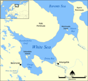
in the southwest. From the north, the district borders the White Sea
. Its administrative center is the town of Mezen
. District's population:
and then colonized by the Novgorod Republic
. After the fall of Novgorod, the area became a part of the Grand Duchy of Moscow
. In particular, Komi
started moving to the Mezen in the 14th and 15th centuries. First Russian settlements on the Mezen were mentioned in the 16th century. The lower course of the Mezen, the current area of the district, was where Russian culture existed in its original state, not mixing with the Komi culture. The town of Mezen
was founded in the 16th century as Okladnikova Sloboda. The area was at the time located on one of the main ways from central Russia to the Pechora River
basin and to the Ural Mountains
.
In the course of the administrative reform carried out in 1708 by Peter the Great, the area was included into Archangelgorod Governorate
. In 1780, the governorate was abolished and transformed into Vologda Viceroyalty
, and Mezen got the town rights. In 1796, the area was transferred to Arkhangelsk Governorate
. The current territory of the district was included into Mezensky Uyezd. On December 28, 1917, a new Ust-Vashsky Uyezd with the center in Ust-Vashka (currently Leshukonskoye
) was established; however, in 1925 it was merged back into Mezensky Uyezd. In 1929, several governorates were merged into Northern Krai
. On July 15, 1929 the uyezds were abolished, and Mezensky District was established. It became a part of Arkhangelsk Okrug of Northern Krai. In the following years, the first-level administrative division of Russia kept changing. In 1930, the okrug was abolished, and the district became subordinate to the central administration of Northern Krai. In 1936, the krai itself was transformed into Northern Oblast. In 1937, Northern Oblast was split into Arkhangelsk Oblast and Vologda Oblast. Mezensky District remained in Arkhangelsk Oblast ever since.
 The district is elongated from west to east. The major part of the district belongs to the river basins of the Mezen
(with the main tributaries, the Pyoza
and the Kimzha
) and the Kuloy
(with the Nemnyuga
and the Soyana
), which both end up in the Mezen Bay
of the White Sea
. Areas on the White Sea coast drain directly into the sea, and some areas in the northeast of the district drain into the Pyosha River and other rivers of the Barents Sea
basin.
Almost the whole of the district is covered by coniferous forests (taiga
). The northern part of the district is transitional area between taiga and tundra
(lesotundra). There are many glacial lakes across the district. The biggest lakes are east of the Mezen, Lake Varsh
(shared with Nenets Autonomous Okrug), Lake Pocha, and Lake Vyzhletskoye.
The district also includes Morzhovets Island
which separates the Mezen Bay from the entrance of the White Sea. The island is the only part of the district which lies above the Arctic Circle
.
The part of the district located east of the Mezen is essentially unpopulated, with the exceptions of the right bank of the river and of several villages in the valley of the Pyoza.
s, one town (Mezen
), and one urban-type settlement (Kamenka
). The following selsoviets have been established (the administrative centers are given in parentheses):
, intended to protect the borders of Russian Federation from unwanted activity. In particular, the town of Mezen
, the urban-type settlement of Kamenka
, and the whole White Sea coast within the district, including the settlements of Ruchyi, Koyda, and Dolgoshchelye, as well as Morzhovets Island, are included into this restricted area. In order to visit the zone, a permit issued by the local FSB department is required.
of the Kuloy River
was the main harbor of fishermen. In Soviet times, the fishery in the Arctic Ocean was state-sponsored; after 1990 the funds were cut, and the fishery went into decline.
The special breed of horses, Mezen horse, was bred in the Mezen River valley. The Mezen horses are rather small but suitable for difficult work and easily survive cold winters.
and the Kuloy Rivers
are navigable within the district limits; however, there is no passenger navigation except for the ferry boats across the rivers. Until 2008, there were no all-seasonal roads in the district. During winter, temporary roads (zimnik
s) are built in snow; in summer, the air transport is the only means for passenger connections to Arkhangelsk and the rest of the world. Currently, there is one all-seasonal road which connects the selo of Kimzha with Arkhangelsk via Pinega
, and two branches from this road along the right bank of the Mezen. One branch runs north to the town of Mezen, whereas the second one runs south to the selo of Leshukonskoye
.
There is an airport
in Mezen, with several weekly flights to Arkhangelsk. There is also the airport in Kamenka.
The majority of the villages of the district are not connected by all-season roads to the main road network, and the only means of getting to Mezen and Arkhangelsk is by air.
s, peasant and merchant houses.
The only state museum in the district is the Mezen Regional Museum, located in the town of Mezen.
Raion
A raion is a type of administrative unit of several post-Soviet countries. The term, which is from French rayon 'honeycomb, department,' describes both a type of a subnational entity and a division of a city, and is commonly translated in English as "district"...
), one of the twenty-one
Administrative divisions of Arkhangelsk Oblast
Administratively, Arkhangelsk Oblast is divided into six cities and towns of oblast significance, twenty-one districts, and two island territories . Besides, Mirny is a town under the federal government management....
in Arkhangelsk Oblast
Arkhangelsk Oblast
Arkhangelsk Oblast is a federal subject of Russia . It includes the Arctic archipelagos of Franz Josef Land and Novaya Zemlya, as well as the Solovetsky Islands in the White Sea....
, Russia
Russia
Russia or , officially known as both Russia and the Russian Federation , is a country in northern Eurasia. It is a federal semi-presidential republic, comprising 83 federal subjects...
. Municipally, it is incorporated as Mezensky Municipal District. It is located in the northeast of the oblast
Oblast
Oblast is a type of administrative division in Slavic countries, including some countries of the former Soviet Union. The word "oblast" is a loanword in English, but it is nevertheless often translated as "area", "zone", "province", or "region"...
and borders with Nenets Autonomous Okrug
Nenets Autonomous Okrug
Nenets Autonomous Okrug is a federal subject of Russia .It has an area of 176,700 km2 and population of 42,628 as of the preliminary results of the 2010 Census , 21,296 of whom live in Naryan-Mar, the administrative center.-Geography and ecology:The arctic ecology of this...
in the northeast, Ust-Tsilemsky District
Ust-Tsilemsky District
Ust-Tsilemsky District is an administrative district , one of the twelve in the Komi Republic, Russia. Municipally, it is incorporated as Ust-Tsilemsky Municipal District. Its administrative center is the rural locality of Ust-Tsilma...
of the Komi Republic
Komi Republic
The Komi Republic is a federal subject of Russia .-Geography:The republic is situated to the west of the Ural mountains, in the north-east of the East European Plain...
in the east, Leshukonsky
Leshukonsky District
Leshukonsky District is an administrative district , one of the twenty-one in Arkhangelsk Oblast, Russia. Municipally, it is incorporated as Leshukonsky Municipal District...
and Pinezhsky District
Pinezhsky District
Pinezhsky District is an administrative district , one of the twenty-one in Arkhangelsk Oblast, Russia. Municipally, it is incorporated as Pinezhsky Municipal District...
s in the south, and Primorsky District
Primorsky District, Arkhangelsk Oblast
Primorsky District is an administrative district , one of the twenty-one in Arkhangelsk Oblast, Russia. Municipally, it is incorporated as Primorsky Municipal District...
in the southwest. From the north, the district borders the White Sea
White Sea
The White Sea is a southern inlet of the Barents Sea located on the northwest coast of Russia. It is surrounded by Karelia to the west, the Kola Peninsula to the north, and the Kanin Peninsula to the northeast. The whole of the White Sea is under Russian sovereignty and considered to be part of...
. Its administrative center is the town of Mezen
Mezen
-See also:*Administrative divisions of Arkhangelsk Oblast...
. District's population:
History
The area was originally populated by the Finno-Ugric peoplesFinno-Ugric peoples
The Finno-Ugric peoples are any of several peoples of Europe who speak languages of the proposed Finno-Ugric language family, such as the Finns, Estonians, Mordvins, and Hungarians...
and then colonized by the Novgorod Republic
Novgorod Republic
The Novgorod Republic was a large medieval Russian state which stretched from the Baltic Sea to the Ural Mountains between the 12th and 15th centuries, centred on the city of Novgorod...
. After the fall of Novgorod, the area became a part of the Grand Duchy of Moscow
Grand Duchy of Moscow
The Grand Duchy of Moscow or Grand Principality of Moscow, also known in English simply as Muscovy , was a late medieval Rus' principality centered on Moscow, and the predecessor state of the early modern Tsardom of Russia....
. In particular, Komi
Komi peoples
The Komi people is an ethnic group whose homeland is in the north-east of European Russia around the basins of the Vychegda, Pechora and Kama rivers. They mostly live in the Komi Republic, Perm Krai, Murmansk Oblast, Khanty-Mansi Autonomous Okrug, and Yamalo-Nenets Autonomous Okrug in the Russian...
started moving to the Mezen in the 14th and 15th centuries. First Russian settlements on the Mezen were mentioned in the 16th century. The lower course of the Mezen, the current area of the district, was where Russian culture existed in its original state, not mixing with the Komi culture. The town of Mezen
Mezen
-See also:*Administrative divisions of Arkhangelsk Oblast...
was founded in the 16th century as Okladnikova Sloboda. The area was at the time located on one of the main ways from central Russia to the Pechora River
Pechora River
The Pechora River is a river in northwest Russia which flows north into the Arctic Ocean on the west side of the Ural Mountains. It lies mostly in the Komi Republic but the northernmost part crosses the Nenets Autonomous Okrug. It is 1,809 km long and its basin is 322,000 square kilometers...
basin and to the Ural Mountains
Ural Mountains
The Ural Mountains , or simply the Urals, are a mountain range that runs approximately from north to south through western Russia, from the coast of the Arctic Ocean to the Ural River and northwestern Kazakhstan. Their eastern side is usually considered the natural boundary between Europe and Asia...
.
In the course of the administrative reform carried out in 1708 by Peter the Great, the area was included into Archangelgorod Governorate
Archangelgorod Governorate
Archangelgorod Governorate , or the Government of Archangelgorod, was an administrative division of the Russian Empire, which existed from 1708 until 1780. Its seat was in Archangel...
. In 1780, the governorate was abolished and transformed into Vologda Viceroyalty
Vologda Viceroyalty
Vologda Viceroyalty was an administrative division of the Russian Empire, which existed in 1780–1796.The viceroyalty was established by a decree of Catherine II on , 1780...
, and Mezen got the town rights. In 1796, the area was transferred to Arkhangelsk Governorate
Arkhangelsk Governorate
Archangelsk Governorate was an administrative division of the Russian Empire, which existed from 1796 until 1929. Its seat was in Arkhangelsk...
. The current territory of the district was included into Mezensky Uyezd. On December 28, 1917, a new Ust-Vashsky Uyezd with the center in Ust-Vashka (currently Leshukonskoye
Leshukonskoye
Leshukonskoye is a rural locality and the administrative center of Leshukonsky District, Arkhangelsk Oblast, Russia, located on the left bank of the Vashka River. It also serves as the administrative center of Leshukonsky Selsoviet, one of the thirteen selsoviets into which the district is...
) was established; however, in 1925 it was merged back into Mezensky Uyezd. In 1929, several governorates were merged into Northern Krai
Northern Krai
Northern Krai was a krai of the Russian Soviet Federative Socialist Republic from 1929 to 1936. Its seat was in the city of Arkhangelsk...
. On July 15, 1929 the uyezds were abolished, and Mezensky District was established. It became a part of Arkhangelsk Okrug of Northern Krai. In the following years, the first-level administrative division of Russia kept changing. In 1930, the okrug was abolished, and the district became subordinate to the central administration of Northern Krai. In 1936, the krai itself was transformed into Northern Oblast. In 1937, Northern Oblast was split into Arkhangelsk Oblast and Vologda Oblast. Mezensky District remained in Arkhangelsk Oblast ever since.
Location and geography
Mezen River
The Mezen is a river in Udorsky District of the Komi Republic and in Leshukonsky and Mezensky Districts of Arkhangelsk Oblast in Russia. Its mouth is located in the Mezen Bay of the White Sea. Mezen is one of the biggest rivers of European Russia. It is long, and the area of its basin...
(with the main tributaries, the Pyoza
Pyoza River
The Pyoza is a river in Mezensky District of Arkhangelsk Oblast in Russia. It is a right tributary of the Mezen River. It is long, and the area of its basin...
and the Kimzha
Kimzha River
The Kimzha is a river in Leshukonsky and Mezensky Districts of Arkhangelsk Oblast in Russia. It is a left tributary of the Mezen River. It is long, and the area of its basin . The main tributary is the Tyafsora ....
) and the Kuloy
Kuloy River (White Sea)
The Kuloy is a river in Pinezhsky and Mezensky Districts of Arkhangelsk Oblast in Russia. Its mouth is located in the Mezen Bay of the White Sea. It is long, and the area of its basin . The principal tributaries of the Kuloy are the Kyolda , the Nemnyuga , and the Soyana...
(with the Nemnyuga
Nemnyuga River
The Nemnyuga is a river in Leshukonsky, Pinezhsky, and Mezensky Districts of Arkhangelsk Oblast in Russia. It is a right tributary of the Kuloy River. It is long, and the area of its basin...
and the Soyana
Soyana River
The Soyana is a river in Primorsky and Mezensky Districts of Arkhangelsk Oblast in Russia. It is a left tributary of the Kuloy River. It is long, and the area of its basin...
), which both end up in the Mezen Bay
Mezen Bay
The Mezen Bay is located in Arkhangelsk Oblast and Nenets Autonomous Okrug in Northwestern Russia. It is one of four large bays and gulfs of the White Sea, the others being the Dvina Bay, the Onega Bay, and the Kandalaksha Gulf. The Mezen Bay is the easternmost of these, as it lies to the south of...
of the White Sea
White Sea
The White Sea is a southern inlet of the Barents Sea located on the northwest coast of Russia. It is surrounded by Karelia to the west, the Kola Peninsula to the north, and the Kanin Peninsula to the northeast. The whole of the White Sea is under Russian sovereignty and considered to be part of...
. Areas on the White Sea coast drain directly into the sea, and some areas in the northeast of the district drain into the Pyosha River and other rivers of the Barents Sea
Barents Sea
The Barents Sea is a marginal sea of the Arctic Ocean, located north of Norway and Russia. Known in the Middle Ages as the Murman Sea, the sea takes its current name from the Dutch navigator Willem Barents...
basin.
Almost the whole of the district is covered by coniferous forests (taiga
Taiga
Taiga , also known as the boreal forest, is a biome characterized by coniferous forests.Taiga is the world's largest terrestrial biome. In North America it covers most of inland Canada and Alaska as well as parts of the extreme northern continental United States and is known as the Northwoods...
). The northern part of the district is transitional area between taiga and tundra
Tundra
In physical geography, tundra is a biome where the tree growth is hindered by low temperatures and short growing seasons. The term tundra comes through Russian тундра from the Kildin Sami word tūndâr "uplands," "treeless mountain tract." There are three types of tundra: Arctic tundra, alpine...
(lesotundra). There are many glacial lakes across the district. The biggest lakes are east of the Mezen, Lake Varsh
Lake Varsh
Lake Varsh is a freshwater lake, shared by Mezensky District of Arkhangelsk Oblast and the Nenets Autonomous Okrug in Russia, just below the Arctic Circle. It is one of the biggest lakes in Arkhangelsk Oblast and the biggest one in Mezensky District...
(shared with Nenets Autonomous Okrug), Lake Pocha, and Lake Vyzhletskoye.
The district also includes Morzhovets Island
Morzhovets Island
Morzhovets Island is an island in the southern limit of the Barents Sea. It is located in Mezen Bay, at the entrance of the White Sea thus separating the Barents Sea and the White Sea.Morzhovets lies only a few km above the Arctic Circle...
which separates the Mezen Bay from the entrance of the White Sea. The island is the only part of the district which lies above the Arctic Circle
Arctic Circle
The Arctic Circle is one of the five major circles of latitude that mark maps of the Earth. For Epoch 2011, it is the parallel of latitude that runs north of the Equator....
.
The part of the district located east of the Mezen is essentially unpopulated, with the exceptions of the right bank of the river and of several villages in the valley of the Pyoza.
Divisions
Administratively, the district is divided into thirteen selsovietSelsoviet
Selsoviet is a shortened name for a rural council. The full names for the term are, in , , . Selsoviets were the lowest level of administrative division in rural areas in the Soviet Union...
s, one town (Mezen
Mezen
-See also:*Administrative divisions of Arkhangelsk Oblast...
), and one urban-type settlement (Kamenka
Kamenka, Arkhangelsk Oblast
Kamenka is an urban locality in Mezensky District of Arkhangelsk Oblast, Russia, located on the left bank of the Mezen River at the mouth of the Kamenka River , some northwest of Mezen...
). The following selsoviets have been established (the administrative centers are given in parentheses):
- Bychensky (Bychye)
- Dolgoshchelsky (Dolgoshchelye)
- Dorogorsky (Dorogorskoye)
- Koydensky (Koyda)
- Kozmogorodsky (Kozmogorodskoye)
- Lampozhensky (Lampozhnya)
- Moseyevsky (Moseyevo)
- Ruchyovsky (Ruchyi)
- Sovpolsky (Chizhgora)
- Soyansky (Soyana)
- Tselegorsky (Tselegora)
- Yolkinsky (Safonovo)
- Zherdsky (Zherd).
Municipal divisions
Municipally, the district is divided into two urban settlements and twelve rural settlements (the administrative centers are given in parentheses):- Mezenskoye Urban Settlement (MezenMezen-See also:*Administrative divisions of Arkhangelsk Oblast...
); - Kamenskoye Urban Settlement (KamenkaKamenka, Arkhangelsk OblastKamenka is an urban locality in Mezensky District of Arkhangelsk Oblast, Russia, located on the left bank of the Mezen River at the mouth of the Kamenka River , some northwest of Mezen...
); - Bychenskoye Rural Settlement (Bychye);
- Dolgoshchelskoye Rural Settlement (Dolgoshchelye);
- Dorogorskoye Rural Settlement (Dorogorskoye);
- Koydenskoye Rural Settlement (Koyda);
- Kozmogorodskoye Rural Settlement (Kozmogorodskoye);
- Moseyevskoye Rural Settlement (Moseyevo);
- Ruchyovskoye Rural Settlement (Ruchyi);
- Safonovskoye Rural Settlement (Safonovo);
- Sovpolskoye Rural Settlement (Chizhgora);
- Soyanskoye Rural Settlement (Soyana);
- Tselegorskoye Rural Settlement (Tselegora);
- Zherdskoye Rural Settlement (Zherd).
Restricted access
The northern part of the district is included into border security zoneBorder Security Zone of Russia
The Border Security Zone in Russia is the designation of a strip of land where economic activity and access are restricted without permission of the FSB. In order to visit the zone, a permit issued by the local FSB department is required. The restricted access zone The Border Security Zone in...
, intended to protect the borders of Russian Federation from unwanted activity. In particular, the town of Mezen
Mezen
-See also:*Administrative divisions of Arkhangelsk Oblast...
, the urban-type settlement of Kamenka
Kamenka, Arkhangelsk Oblast
Kamenka is an urban locality in Mezensky District of Arkhangelsk Oblast, Russia, located on the left bank of the Mezen River at the mouth of the Kamenka River , some northwest of Mezen...
, and the whole White Sea coast within the district, including the settlements of Ruchyi, Koyda, and Dolgoshchelye, as well as Morzhovets Island, are included into this restricted area. In order to visit the zone, a permit issued by the local FSB department is required.
Agriculture
Historically, fishery was the main source of income in the White Sea coast. The selo of Dolgoshchelye in the estuaryEstuary
An estuary is a partly enclosed coastal body of water with one or more rivers or streams flowing into it, and with a free connection to the open sea....
of the Kuloy River
Kuloy River (White Sea)
The Kuloy is a river in Pinezhsky and Mezensky Districts of Arkhangelsk Oblast in Russia. Its mouth is located in the Mezen Bay of the White Sea. It is long, and the area of its basin . The principal tributaries of the Kuloy are the Kyolda , the Nemnyuga , and the Soyana...
was the main harbor of fishermen. In Soviet times, the fishery in the Arctic Ocean was state-sponsored; after 1990 the funds were cut, and the fishery went into decline.
The special breed of horses, Mezen horse, was bred in the Mezen River valley. The Mezen horses are rather small but suitable for difficult work and easily survive cold winters.
Transport
Both the MezenMezen River
The Mezen is a river in Udorsky District of the Komi Republic and in Leshukonsky and Mezensky Districts of Arkhangelsk Oblast in Russia. Its mouth is located in the Mezen Bay of the White Sea. Mezen is one of the biggest rivers of European Russia. It is long, and the area of its basin...
and the Kuloy Rivers
Kuloy River (White Sea)
The Kuloy is a river in Pinezhsky and Mezensky Districts of Arkhangelsk Oblast in Russia. Its mouth is located in the Mezen Bay of the White Sea. It is long, and the area of its basin . The principal tributaries of the Kuloy are the Kyolda , the Nemnyuga , and the Soyana...
are navigable within the district limits; however, there is no passenger navigation except for the ferry boats across the rivers. Until 2008, there were no all-seasonal roads in the district. During winter, temporary roads (zimnik
Winter road
Winter roads are temporary highways carved out of snow and ice. They facilitate transportation to and from communities without permanent roads, and are commonly seen in isolated regions in Canada's north....
s) are built in snow; in summer, the air transport is the only means for passenger connections to Arkhangelsk and the rest of the world. Currently, there is one all-seasonal road which connects the selo of Kimzha with Arkhangelsk via Pinega
Pinega
Pinega is a settlement, formerly a town, in Pinezhsky District, Arkhangelsk Oblast, Russia, located on the right bank of the Pinega River . It serves as the administrative center of Pinezhsky Selsoviet, one of the seventeen selsoviets into which the district is administratively divided...
, and two branches from this road along the right bank of the Mezen. One branch runs north to the town of Mezen, whereas the second one runs south to the selo of Leshukonskoye
Leshukonskoye
Leshukonskoye is a rural locality and the administrative center of Leshukonsky District, Arkhangelsk Oblast, Russia, located on the left bank of the Vashka River. It also serves as the administrative center of Leshukonsky Selsoviet, one of the thirteen selsoviets into which the district is...
.
There is an airport
Mezen Airport
Mezen Airport is an airport in Arkhangelsk Oblast, Russia located 4 km north of Mezen. It handles small transport planes. There are several weekly flights to Arkhangelsk and several flights per month to the remote locations of Mezensky District — the selos of Koyda, Moseyevo, and Safonovo.In...
in Mezen, with several weekly flights to Arkhangelsk. There is also the airport in Kamenka.
The majority of the villages of the district are not connected by all-season roads to the main road network, and the only means of getting to Mezen and Arkhangelsk is by air.
Culture and recreation
The district contains two objects classified as cultural and historical heritage by Russian Federal law, and additionally a number of objects classified as cultural and historical heritage of local importance. The objects under federal protection are the wooden bell tower in the selo of Dolgoshchelye (burnt down in 1994 and does not exist anymore) and the wooden Hodegetria Church in the selo of Kimzha (1709, currently disassembled). The objects under local protection are wooden churches, chapels, windmillWindmill
A windmill is a machine which converts the energy of wind into rotational energy by means of vanes called sails or blades. Originally windmills were developed for milling grain for food production. In the course of history the windmill was adapted to many other industrial uses. An important...
s, peasant and merchant houses.
The only state museum in the district is the Mezen Regional Museum, located in the town of Mezen.