
Mellor, Greater Manchester
Encyclopedia
Mellor is a village within the Metropolitan Borough of Stockport
, in Greater Manchester
, England. Mellor, situated between Marple Bridge
and New Mills
, runs along a tributary
of the River Goyt. It extends from the start of the old turnpike
road at the boundary of Marple Bridge
to the current county boundary with Derbyshire
. Mellor no longer has any shops, so people now shop in Marple Bridge, Marple
or further afield. It has a church, primary school, golf course, sports club and a riding school. There are three pubs in the village, The Royal Oak, The Devonshire Arms, and The Oddfellows Arms. There is also a fourth pub, the Hare and Hounds in the hamlet of Mill Brow, which was formerly part of the civil parish
of Mellor. An independent census from 1891 lists several of these pubs and a complex of shops and industries which no longer exist.
As with virtually all towns and villages in Britain, there is a World War I memorial, situated in a small park at the very heart of the modern village. Farmland takes the bulk of the remaining space, although with the decline in the farming economy in recent years, much of it is now given over to non-agricultural uses: horses, golf, and a scout camp. A number of farm buildings and Mellor Hall
date back to the late 17th century, and were built on ruins of earlier buildings, illustrating the long-standing importance of agriculture to Mellor. The village was a civil parish
in the county of Derbyshire
until 1936, when it was transferred to Marple Urban District
in Cheshire; in 1974 it became part of Greater Manchester
.
. Although some history had survived by means of written records and local tradition, it has become clear that such knowledge only scratched the surface and that the extent of Mellor's past had passed from such memories.
The origin of the name "Mellor" is uncertain. In one Celtic
dialect, the term would translate to "the bare (or rounded) hill". The name "Mellor" does not appear in the Norman-era Domesday Book, although the neighbouring town of Ludworth (recorded as Lodeuorde) is listed. It is possible that Ludworth originally included Mellor and that they split into two distinct areas at a later date.
The Saxons
built a church at the southern-most end of the Iron Age settlement some time in the 7th or 8th centuries. The church was subsequently destroyed and rebuilt, possibly several times. St. Thomas Church
has the oldest known wooden pulpit in Britain, possibly the world. Dating from the reign of Edward II
(1307–1327), it is ogtagonal and carved from a single piece of wood. The church also has a 12th century font
.
According to local legend, Mellor Hall is built on the foundations of the house of a Norman nobleman. During excavations of the Iron Age hill fort, a 13th century hall was discovered. By the time of the English Civil War, Marple had become totally dominant in the region. So much so that John Bradshawe
, Lord President of the High Court of Justice and Lord of Marple Hall was the first to sign the death warrant of King Charles I.
Samuel Oldknow
was a significant businessman and mill owner in Mellor during the Industrial Revolution
. Just across the River Goyt, there are the "Roman Lakes". These are not Roman
, but were water reservoirs for Samuel Oldknow's Mellor Mill cotton mill, a major employer in the area in the Industrial Revolution.
One of the local stories involves the fate of Samuel Oldknow's mill at the Roman Lakes, which was destroyed by fire in November 1892. Accidents at such mills were common, but so were violent rivalries. There have been claims made for both cases. The only thing that can be stated with any certainty is that the mill was gutted by the blaze.
The other major figure in Mellor at this time was William Radcliffe
, a mill owner who invented many devices for improving the textile industry.
At the height of the Industrial Revolution, coal-power supplanted water-power as the driving force and minable coal seams were found in Mellor. Relatively recently, the British Coal Board strip-mined those seams that still had sufficient coal in them.
, just outside the area of Derbyshire known as the High Peak. Nearby villages include Rowarth
, Marple Bridge, Ludworth
and Mill Brow. The town of Marple lies across the River Goyt. A little further away are the towns of Romiley
and New Mills
and the villages of Hayfield
and Strines
. Mellor Church and Mellor Hall
are situated on the top of a ridge
that is separated from the bulk of the village of Mellor by a gully and stream.
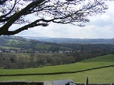
The oldest part of inhabited Mellor runs alongside the river Goyt, stretching from the oldest parts of Marple Bridge up the hill, spreading out where the slope becomes gentle. Newer parts of the village run down Longhurst Lane, the old turnpike road, and into former farmland released for building by Townscliffe Farm. At the very top of Mellor is the junction of Five Ways. One of these roads runs to Mellor, a second to Rowarth, a third to Strines and New Mills, the fourth to a water treatment plant and a fifth to many farms on the edge of Mellor. Spoil heaps indicate mining operations here and coal was mined in the general area during the Industrial Revolution.
Because of the topology, Mellor lies on one of the easier points for entering the Pennines from the Mersey Basin by road or foot. It is also on the flight path for air traffic into Manchester Airport, formerly known as Ringway.
area in an area of the Peak District
referred to as the Dark Peak
. (In contrast, the limestone
region of the Peak District is referred to as the White Peak
.) The underlying geology of the area belongs to the Carboniferous
Millstone Grit series which are outcrop as the Middle Grit. Below this are shales and mudstones and older Gritstones such as the Kinder Scout Grit which forms the Kinder Plateau to the East. Small seams of coal have been located in Mellor, over the gritstone. Boulder clay
, left from the Ice Age
, can usually be found just below the surface-level soil. At one point, all of the Peak District – Mellor included – was submerged beneath relatively warm waters. Evidence for this is the limestone region, with the limestone containing fossils of coral
and other shallow-depth warm-water creatures.
The gritstone comes from deposits laid down about 300 million years ago over the limestone. Shallow coal deposits lie on top of the gritstone, although most of these have long since been mined. Very deep coal deposits do exist further into the Pennines, but again many of these have been worked out. Although evidence exists for volcanos elsewhere in the Peak District,
The soil in Mellor is fairly rich in peat
and can bog easily, but there are no permanent peat bogs within Mellor itself. The only other noteworthy detail on Mellor's geology is the almost complete absence of iodine
, particularly in the water of the River Goyt. If no other source of iodine is in the diet
, drinking the river water can lead to an enlarged thyroid gland, a condition is known as "Derbyshire Neck", or Goitre
.
, Mellor became a part of Stockport metropolitan borough
.
The voters of Mellor consist of, in almost equal numbers, Liberal Democrats and Conservatives
. Labour
have never done well here. Mellor is not noted for being particularly active on the political front. Nonetheless, turnout for elections is often very high.
According to the Office for National Statistics
, at the time of the United Kingdom Census 2001
, Mellor had a population of 2,394. The 2001 population density was 2771 PD/sqmi, with a 100 to 92.1 female-to-male ratio. Of those over 16 years old, 18.8% were single (never married), 54.6% married, and 6.6% divorced. This was significantly different to the borough and country figures, with a higher rate of marriages, and fewer single people. Mellor's 1,070 households included 27.4% one-person, 43.5% married couples living together, 5.7% were co-habiting
couples, and 5.9% single parents with their children. Of those aged 16–74, 20.9% had no academic qualifications
.
As of the 2001 UK census, 88.4% of Mellor's residents reported themselves as Christian, 1.0% Muslim, and 0.2% Hindu. The census recorded 5.8% as having no religion, 0.2% had an alternative religion and 4.4% did not state their religion.
A few small businesses work out of the old mills that scatter the countryside, and there is a limited amount of farming, principally grazing livestock: sheep and beef cattle. A few farms have free-range chickens, but the majority of poultry are battery-farmed. Horses are also common, and horse-riding is a popular pursuit in the area, which benefits from many ancient bridleways.
According to the 2001 UK census, the industry of employment of residents of Mellor aged 16–74 was 18.3% manufacturing, 16.3% retail and wholesale, 12.2% health and social work, 12.0% education, 11.7% property and business services, 6.6 public administration, 4.6% construction, 4.5% transport and communications, 4.2% hotels and restaurants, 2.7% finance, 2.0% agriculture, 0.7% energy and water supply, and 4.2% other. Compared with national figures, the town had a relatively high proportion of people working in education, agriculture, and public administration, and low levels of people working in finance and transport and communications. The census recorded the economic activity of residents aged 16–74, 1.8% students were with jobs, 3.4% students without jobs, 3.1% looking after home or family, 4.1% permanently sick or disabled, and 1.1% economically inactive for other reasons.
Lacrosse
Mellor is probably best known for being a hotbed of lacrosse
. The club has enjoyed great success in its 80 year history, winning the North of England men's championship on many occasions, the most recent being 2006. The club has three men's senior teams and a thriving junior section and has recently created a ladies team. The club also regularly plays host to touring teams from the USA at junior and senior level. The success of the club can be gauged by the fact that many Mellor players have gone on to play at international level. Although recantly relegated for the first time since the War, Mellor is still considered by many in the country to be one of the most dangerous competitors in lacrosse.
Football
Mellor Football Club was founded in 1923 by members of the Hambleton Family. Mellor FC's home ground is Wood Lane in Marple, and the club currently boasts four open-age teams. Mellor 1st XI are currently in the Premier Division of the Lancashire and Cheshire League and won the Stockport Senior Cup in the 2004/05 season.
Cricket
Mellor Cricket
Club had two senior teams that played in the Derbyshire and Cheshire League having previously played in the Glossop and District League for many years and before that, in the High Peak League. They now play in the Cheshire County League 3rd XI Saturday Division 2 under "Marple-Mellor" having resigned from the Derbyshire and Cheshire League in 2008
Tennis
The tennis club was formed around the end of the Second World War, between 1945 and 1950. It originally had only one grass court. This was later extended to include two shale courts and later to include two all-weather courts. These were then replaced with astroturf. It has three men's and three ladies' teams in the Slazenger North East Cheshire League.
Badminton
Mellor's badminton club has eight teams – two teams in the Tameside Badminton League, three in the Stockport Badminton League and three Junior teams in the Stockport Badminton League.
Golf
The Golf course runs through a sparsely-populated section of the oldest inhabited part of Mellor. The course offers a very clear view over Greater Manchester and on a clear day the Welsh Mountains can be seen. The 15th hole is regarded by some as the signature hole, a double dog leg par 5.
Some of these societies run charitable events in the area. For example, Every four years the local residents open a number of private gardens during an event known as the Mellor Open Gardens day. The purpose of the event is to raise funds for Cancer Research UK and the support of the local Parish Centre. Another event is the Mellor March, in which ramblers carry out a sponsored walk to traverse the boundary of Mellor
, the treasurer of the freemasonry
lodge in Mellor around 1785. He had his gravestone carved, using a masonic cipher
called 'Pigpen
', some years prior to his death. The text at the head of the stone says "Thomas Brierley made his ingress July 16, 1785". The cipher at the foot of the gravestone says "Holiness of the Lord". The Pigpen Cipher was used by Freemasons in the 18th century to keep their records private and surprisingly the cipher on Thomas Brierley's grave seems have a non-standard symbol for the letter "S". It is possible the variation in the cipher is a clue to or a key to documents that he dealt with as the treasurer but more likely a simple error.
According to some, Thomas Brierley fell to his death from the church tower, but other sources disagree so this story may be an urban legend. To add to the mystery, a bronze plaque was added to the stone in recent times with more cipher upon it, the cipher used being similar but not identical.
Geography
Historical information for Mellor
Metropolitan Borough of Stockport
The Metropolitan Borough of Stockport is a metropolitan borough of Greater Manchester, in north west England, centred around the town of Stockport. It has a population of about 280,600 and includes the outyling areas of Cheadle and Cheadle Hulme, Marple, Bredbury, Reddish and Romiley...
, in Greater Manchester
Greater Manchester
Greater Manchester is a metropolitan county in North West England, with a population of 2.6 million. It encompasses one of the largest metropolitan areas in the United Kingdom and comprises ten metropolitan boroughs: Bolton, Bury, Oldham, Rochdale, Stockport, Tameside, Trafford, Wigan, and the...
, England. Mellor, situated between Marple Bridge
Marple Bridge
Marple Bridge is a village within the Metropolitan Borough of Stockport, in Greater Manchester, England. It lies on the River Goyt, which runs through the centre of the village, and is close to the town of Marple....
and New Mills
New Mills
New Mills is a town in Derbyshire, England approximately south-east of Stockport and from Manchester. It is sited at the confluence of the rivers Goyt and Sett, on the border of Cheshire. The town stands above the Torrs, a deep gorge, cut through Woodhead Hill Sandstone of the Carboniferous period...
, runs along a tributary
Tributary
A tributary or affluent is a stream or river that flows into a main stem river or a lake. A tributary does not flow directly into a sea or ocean...
of the River Goyt. It extends from the start of the old turnpike
Turnpike trust
Turnpike trusts in the United Kingdom were bodies set up by individual Acts of Parliament, with powers to collect road tolls for maintaining the principal highways in Britain from the 17th but especially during the 18th and 19th centuries...
road at the boundary of Marple Bridge
Marple Bridge
Marple Bridge is a village within the Metropolitan Borough of Stockport, in Greater Manchester, England. It lies on the River Goyt, which runs through the centre of the village, and is close to the town of Marple....
to the current county boundary with Derbyshire
Derbyshire
Derbyshire is a county in the East Midlands of England. A substantial portion of the Peak District National Park lies within Derbyshire. The northern part of Derbyshire overlaps with the Pennines, a famous chain of hills and mountains. The county contains within its boundary of approx...
. Mellor no longer has any shops, so people now shop in Marple Bridge, Marple
Marple, Greater Manchester
Marple is a small town within the Metropolitan Borough of Stockport, in Greater Manchester, England. It lies on the River Goyt southeast of Stockport.Historically part of Cheshire, Marple has a population of 23,480 .-Toponymy:...
or further afield. It has a church, primary school, golf course, sports club and a riding school. There are three pubs in the village, The Royal Oak, The Devonshire Arms, and The Oddfellows Arms. There is also a fourth pub, the Hare and Hounds in the hamlet of Mill Brow, which was formerly part of the civil parish
Civil parish
In England, a civil parish is a territorial designation and, where they are found, the lowest tier of local government below districts and counties...
of Mellor. An independent census from 1891 lists several of these pubs and a complex of shops and industries which no longer exist.
As with virtually all towns and villages in Britain, there is a World War I memorial, situated in a small park at the very heart of the modern village. Farmland takes the bulk of the remaining space, although with the decline in the farming economy in recent years, much of it is now given over to non-agricultural uses: horses, golf, and a scout camp. A number of farm buildings and Mellor Hall
Mellor Hall
Mellor Hall is a 15th century hall in Mellor, in the Metropolitan Borough of Stockport, Greater Manchester, England . The completion date of the hall is uncertain but it is thought to be 1688. It, and the adjoining farmhouse, originally a smithy, is a Grade II* listed building....
date back to the late 17th century, and were built on ruins of earlier buildings, illustrating the long-standing importance of agriculture to Mellor. The village was a civil parish
Civil parish
In England, a civil parish is a territorial designation and, where they are found, the lowest tier of local government below districts and counties...
in the county of Derbyshire
Derbyshire
Derbyshire is a county in the East Midlands of England. A substantial portion of the Peak District National Park lies within Derbyshire. The northern part of Derbyshire overlaps with the Pennines, a famous chain of hills and mountains. The county contains within its boundary of approx...
until 1936, when it was transferred to Marple Urban District
Marple, Greater Manchester
Marple is a small town within the Metropolitan Borough of Stockport, in Greater Manchester, England. It lies on the River Goyt southeast of Stockport.Historically part of Cheshire, Marple has a population of 23,480 .-Toponymy:...
in Cheshire; in 1974 it became part of Greater Manchester
Greater Manchester
Greater Manchester is a metropolitan county in North West England, with a population of 2.6 million. It encompasses one of the largest metropolitan areas in the United Kingdom and comprises ten metropolitan boroughs: Bolton, Bury, Oldham, Rochdale, Stockport, Tameside, Trafford, Wigan, and the...
.
History
The ancient past of Mellor is slowly being discovered as a result of a long-term archaeological survey of the area by means of excavations and geophysical surveys, including ground-penetrating radarGround-penetrating radar
Ground-penetrating radar is a geophysical method that uses radar pulses to image the subsurface. This nondestructive method uses electromagnetic radiation in the microwave band of the radio spectrum, and detects the reflected signals from subsurface structures...
. Although some history had survived by means of written records and local tradition, it has become clear that such knowledge only scratched the surface and that the extent of Mellor's past had passed from such memories.
The origin of the name "Mellor" is uncertain. In one Celtic
Celtic languages
The Celtic languages are descended from Proto-Celtic, or "Common Celtic"; a branch of the greater Indo-European language family...
dialect, the term would translate to "the bare (or rounded) hill". The name "Mellor" does not appear in the Norman-era Domesday Book, although the neighbouring town of Ludworth (recorded as Lodeuorde) is listed. It is possible that Ludworth originally included Mellor and that they split into two distinct areas at a later date.
The Saxons
Saxons
The Saxons were a confederation of Germanic tribes originating on the North German plain. The Saxons earliest known area of settlement is Northern Albingia, an area approximately that of modern Holstein...
built a church at the southern-most end of the Iron Age settlement some time in the 7th or 8th centuries. The church was subsequently destroyed and rebuilt, possibly several times. St. Thomas Church
St. Thomas' Church, Mellor
St. Thomas' Church, Mellor is at the end of a lane overlooking the village of Mellor, Greater Manchester, England. It has been designated by English Heritage as a Grade II listed building. The church contains the oldest wooden pulpit in England and a late 12th-century Norman font...
has the oldest known wooden pulpit in Britain, possibly the world. Dating from the reign of Edward II
Edward II of England
Edward II , called Edward of Caernarfon, was King of England from 1307 until he was deposed by his wife Isabella in January 1327. He was the sixth Plantagenet king, in a line that began with the reign of Henry II...
(1307–1327), it is ogtagonal and carved from a single piece of wood. The church also has a 12th century font
Baptismal font
A baptismal font is an article of church furniture or a fixture used for the baptism of children and adults.-Aspersion and affusion fonts:...
.
According to local legend, Mellor Hall is built on the foundations of the house of a Norman nobleman. During excavations of the Iron Age hill fort, a 13th century hall was discovered. By the time of the English Civil War, Marple had become totally dominant in the region. So much so that John Bradshawe
John Bradshaw (judge)
John Bradshaw was an English judge. He is most notable for his role as President of the High Court of Justice for the trial of King Charles I and as the first Lord President of the Council of State of the English Commonwealth....
, Lord President of the High Court of Justice and Lord of Marple Hall was the first to sign the death warrant of King Charles I.
Samuel Oldknow
Samuel Oldknow
thumb|Samuel OldknowSamuel Oldknow was an English cotton manufacturer.Samuel Oldknow Jnr, the eldest son of Samuel Oldknow Sr and Margaret Foster, was born 5 October 1756 in Anderton, near Chorley, Lancashire, and died 18 September 1828 at Mellor Lodge, Derbyshire. He had an elder sister named...
was a significant businessman and mill owner in Mellor during the Industrial Revolution
Industrial Revolution
The Industrial Revolution was a period from the 18th to the 19th century where major changes in agriculture, manufacturing, mining, transportation, and technology had a profound effect on the social, economic and cultural conditions of the times...
. Just across the River Goyt, there are the "Roman Lakes". These are not Roman
Ancient Rome
Ancient Rome was a thriving civilization that grew on the Italian Peninsula as early as the 8th century BC. Located along the Mediterranean Sea and centered on the city of Rome, it expanded to one of the largest empires in the ancient world....
, but were water reservoirs for Samuel Oldknow's Mellor Mill cotton mill, a major employer in the area in the Industrial Revolution.
One of the local stories involves the fate of Samuel Oldknow's mill at the Roman Lakes, which was destroyed by fire in November 1892. Accidents at such mills were common, but so were violent rivalries. There have been claims made for both cases. The only thing that can be stated with any certainty is that the mill was gutted by the blaze.
The other major figure in Mellor at this time was William Radcliffe
William Radcliffe
William Radcliffe was a British inventor and author of the essay Origin of the New System of Manufacture, Commonly Called Power loom Weaving.-Biography:...
, a mill owner who invented many devices for improving the textile industry.
At the height of the Industrial Revolution, coal-power supplanted water-power as the driving force and minable coal seams were found in Mellor. Relatively recently, the British Coal Board strip-mined those seams that still had sufficient coal in them.
Geography
Mellor lies in the foothills of the PenninesPennines
The Pennines are a low-rising mountain range, separating the North West of England from Yorkshire and the North East.Often described as the "backbone of England", they form a more-or-less continuous range stretching from the Peak District in Derbyshire, around the northern and eastern edges of...
, just outside the area of Derbyshire known as the High Peak. Nearby villages include Rowarth
Rowarth
Rowarth is a hamlet about 2.5 miles north of New Mills in the High Peak borough of Derbyshire, England. It is on the edge of the Peak District, in the hills between New Mills and Marple Bridge. It is within the boundaries of the former town....
, Marple Bridge, Ludworth
Ludworth, Greater Manchester
Ludworth is an area of Marple, Greater Manchester in Greater Manchester. Ludworth Civil Parish was created in 1896; it was part of Glossop Dale Rural District until 1934 when it was transferred to Chapel-en-le-Frith Rural District. In 1936 it was transferred, along with Mellor to Marple Urban...
and Mill Brow. The town of Marple lies across the River Goyt. A little further away are the towns of Romiley
Romiley
Romiley is an area of the Metropolitan Borough of Stockport, Greater Manchester, England. It borders Marple, Bredbury and Woodley. In Roman times there is thought to have been a settlement along Sandy Lane...
and New Mills
New Mills
New Mills is a town in Derbyshire, England approximately south-east of Stockport and from Manchester. It is sited at the confluence of the rivers Goyt and Sett, on the border of Cheshire. The town stands above the Torrs, a deep gorge, cut through Woodhead Hill Sandstone of the Carboniferous period...
and the villages of Hayfield
Hayfield
Hayfield is a village and civil parish in the Borough of High Peak, in the county of Derbyshire, England. The village lies approximately east of New Mills, south of Glossop and north of Buxton by road....
and Strines
Strines
Strines is a village in Greater Manchester, located in the valley of the River Goyt midway between Marple and New Mills and about six miles southeast of Stockport. The village falls mainly within Marple parish and Stockport metropolitan borough, though a small part falls within the boundaries of...
. Mellor Church and Mellor Hall
Mellor Hall
Mellor Hall is a 15th century hall in Mellor, in the Metropolitan Borough of Stockport, Greater Manchester, England . The completion date of the hall is uncertain but it is thought to be 1688. It, and the adjoining farmhouse, originally a smithy, is a Grade II* listed building....
are situated on the top of a ridge
Ridge
A ridge is a geological feature consisting of a chain of mountains or hills that form a continuous elevated crest for some distance. Ridges are usually termed hills or mountains as well, depending on size. There are several main types of ridges:...
that is separated from the bulk of the village of Mellor by a gully and stream.
The oldest part of inhabited Mellor runs alongside the river Goyt, stretching from the oldest parts of Marple Bridge up the hill, spreading out where the slope becomes gentle. Newer parts of the village run down Longhurst Lane, the old turnpike road, and into former farmland released for building by Townscliffe Farm. At the very top of Mellor is the junction of Five Ways. One of these roads runs to Mellor, a second to Rowarth, a third to Strines and New Mills, the fourth to a water treatment plant and a fifth to many farms on the edge of Mellor. Spoil heaps indicate mining operations here and coal was mined in the general area during the Industrial Revolution.
Because of the topology, Mellor lies on one of the easier points for entering the Pennines from the Mersey Basin by road or foot. It is also on the flight path for air traffic into Manchester Airport, formerly known as Ringway.
Geology
Mellor is located on a gritstoneGritstone
Gritstone or Grit is a hard, coarse-grained, siliceous sandstone. This term is especially applied to such sandstones that are quarried for building material. British gritstone was used for millstones to mill flour, to grind wood into pulp for paper and for grindstones to sharpen blades. "Grit" is...
area in an area of the Peak District
Peak District
The Peak District is an upland area in central and northern England, lying mainly in northern Derbyshire, but also covering parts of Cheshire, Greater Manchester, Staffordshire, and South and West Yorkshire....
referred to as the Dark Peak
Dark Peak
The Dark Peak is the higher, wilder northern part of the Peak District in England.It gets its name because , the underlying limestone is covered by a cap of Millstone Grit which means that in winter the soil is almost always saturated with water...
. (In contrast, the limestone
Limestone
Limestone is a sedimentary rock composed largely of the minerals calcite and aragonite, which are different crystal forms of calcium carbonate . Many limestones are composed from skeletal fragments of marine organisms such as coral or foraminifera....
region of the Peak District is referred to as the White Peak
White Peak
The White Peak is the lower, southern part of the Peak District in England. In contrast to the Dark Peak, the underlying limestone is not capped by impervious millstone grit, so caves and dry river valleys are common features of the area...
.) The underlying geology of the area belongs to the Carboniferous
Carboniferous
The Carboniferous is a geologic period and system that extends from the end of the Devonian Period, about 359.2 ± 2.5 Mya , to the beginning of the Permian Period, about 299.0 ± 0.8 Mya . The name is derived from the Latin word for coal, carbo. Carboniferous means "coal-bearing"...
Millstone Grit series which are outcrop as the Middle Grit. Below this are shales and mudstones and older Gritstones such as the Kinder Scout Grit which forms the Kinder Plateau to the East. Small seams of coal have been located in Mellor, over the gritstone. Boulder clay
Boulder clay
Boulder clay, in geology, is a deposit of clay, often full of boulders, which is formed in and beneath glaciers and ice-sheets wherever they are found, but is in a special sense the typical deposit of the Glacial Period in northern Europe and North America...
, left from the Ice Age
Ice age
An ice age or, more precisely, glacial age, is a generic geological period of long-term reduction in the temperature of the Earth's surface and atmosphere, resulting in the presence or expansion of continental ice sheets, polar ice sheets and alpine glaciers...
, can usually be found just below the surface-level soil. At one point, all of the Peak District – Mellor included – was submerged beneath relatively warm waters. Evidence for this is the limestone region, with the limestone containing fossils of coral
Coral
Corals are marine animals in class Anthozoa of phylum Cnidaria typically living in compact colonies of many identical individual "polyps". The group includes the important reef builders that inhabit tropical oceans and secrete calcium carbonate to form a hard skeleton.A coral "head" is a colony of...
and other shallow-depth warm-water creatures.
The gritstone comes from deposits laid down about 300 million years ago over the limestone. Shallow coal deposits lie on top of the gritstone, although most of these have long since been mined. Very deep coal deposits do exist further into the Pennines, but again many of these have been worked out. Although evidence exists for volcanos elsewhere in the Peak District,
The soil in Mellor is fairly rich in peat
Peat
Peat is an accumulation of partially decayed vegetation matter or histosol. Peat forms in wetland bogs, moors, muskegs, pocosins, mires, and peat swamp forests. Peat is harvested as an important source of fuel in certain parts of the world...
and can bog easily, but there are no permanent peat bogs within Mellor itself. The only other noteworthy detail on Mellor's geology is the almost complete absence of iodine
Iodine
Iodine is a chemical element with the symbol I and atomic number 53. The name is pronounced , , or . The name is from the , meaning violet or purple, due to the color of elemental iodine vapor....
, particularly in the water of the River Goyt. If no other source of iodine is in the diet
Diet (nutrition)
In nutrition, diet is the sum of food consumed by a person or other organism. Dietary habits are the habitual decisions an individual or culture makes when choosing what foods to eat. With the word diet, it is often implied the use of specific intake of nutrition for health or weight-management...
, drinking the river water can lead to an enlarged thyroid gland, a condition is known as "Derbyshire Neck", or Goitre
Goitre
A goitre or goiter , is a swelling in the thyroid gland, which can lead to a swelling of the neck or larynx...
.
Governance
On the creation of Greater ManchesterGreater Manchester
Greater Manchester is a metropolitan county in North West England, with a population of 2.6 million. It encompasses one of the largest metropolitan areas in the United Kingdom and comprises ten metropolitan boroughs: Bolton, Bury, Oldham, Rochdale, Stockport, Tameside, Trafford, Wigan, and the...
, Mellor became a part of Stockport metropolitan borough
Metropolitan Borough of Stockport
The Metropolitan Borough of Stockport is a metropolitan borough of Greater Manchester, in north west England, centred around the town of Stockport. It has a population of about 280,600 and includes the outyling areas of Cheadle and Cheadle Hulme, Marple, Bredbury, Reddish and Romiley...
.
The voters of Mellor consist of, in almost equal numbers, Liberal Democrats and Conservatives
Conservative Party (UK)
The Conservative Party, formally the Conservative and Unionist Party, is a centre-right political party in the United Kingdom that adheres to the philosophies of conservatism and British unionism. It is the largest political party in the UK, and is currently the largest single party in the House...
. Labour
Labour Party (UK)
The Labour Party is a centre-left democratic socialist party in the United Kingdom. It surpassed the Liberal Party in general elections during the early 1920s, forming minority governments under Ramsay MacDonald in 1924 and 1929-1931. The party was in a wartime coalition from 1940 to 1945, after...
have never done well here. Mellor is not noted for being particularly active on the political front. Nonetheless, turnout for elections is often very high.
Demography
| Mellor compared | |||
|---|---|---|---|
| 2001 UK census | Mellor | Stockport (borough) Metropolitan Borough of Stockport The Metropolitan Borough of Stockport is a metropolitan borough of Greater Manchester, in north west England, centred around the town of Stockport. It has a population of about 280,600 and includes the outyling areas of Cheadle and Cheadle Hulme, Marple, Bredbury, Reddish and Romiley... |
England |
| Total population | 2,394 | 284,528 | 49,138,831 |
| White | 98.2% | 95.7% | 90.9% |
| Asian | 1.4% | 2.1% | 4.6% |
| Black | 0% | 0.4% | 2.3% |
According to the Office for National Statistics
Office for National Statistics
The Office for National Statistics is the executive office of the UK Statistics Authority, a non-ministerial department which reports directly to the Parliament of the United Kingdom.- Overview :...
, at the time of the United Kingdom Census 2001
United Kingdom Census 2001
A nationwide census, known as Census 2001, was conducted in the United Kingdom on Sunday, 29 April 2001. This was the 20th UK Census and recorded a resident population of 58,789,194....
, Mellor had a population of 2,394. The 2001 population density was 2771 PD/sqmi, with a 100 to 92.1 female-to-male ratio. Of those over 16 years old, 18.8% were single (never married), 54.6% married, and 6.6% divorced. This was significantly different to the borough and country figures, with a higher rate of marriages, and fewer single people. Mellor's 1,070 households included 27.4% one-person, 43.5% married couples living together, 5.7% were co-habiting
Cohabitation
Cohabitation usually refers to an arrangement whereby two people decide to live together on a long-term or permanent basis in an emotionally and/or sexually intimate relationship. The term is most frequently applied to couples who are not married...
couples, and 5.9% single parents with their children. Of those aged 16–74, 20.9% had no academic qualifications
National Qualifications Framework
The National Qualifications Framework is a credit transfer system developed for qualifications in England, Wales and Northern Ireland....
.
As of the 2001 UK census, 88.4% of Mellor's residents reported themselves as Christian, 1.0% Muslim, and 0.2% Hindu. The census recorded 5.8% as having no religion, 0.2% had an alternative religion and 4.4% did not state their religion.
Population change
| Population growth Population growth Population growth is the change in a population over time, and can be quantified as the change in the number of individuals of any species in a population using "per unit time" for measurement.... in Mellor from 1861 to 1931 |
||||||||
|---|---|---|---|---|---|---|---|---|
| Year | 1861 | 1871 | 1881 | 1891 | 1901 | 1911 | 1921 | 1931 |
| Population | 1,733 | 1,447 | 1,242 | 1,096 | 1,218 | 1,711 | 1,876 | 1,712 |
| Source: A Vision of Britain through Time | ||||||||
Economy
| Mellor compared | |||
|---|---|---|---|
| 2001 UK Census United Kingdom Census 2001 A nationwide census, known as Census 2001, was conducted in the United Kingdom on Sunday, 29 April 2001. This was the 20th UK Census and recorded a resident population of 58,789,194.... |
Mellor | Stockport (borough) | England |
| Population of working age | 1,789 | 151,445 | 35,532,091 |
| Full time employment | 38.8% | 43.3% | 40.8% |
| Part time employment | 12.0% | 12.5% | 11.8% |
| Self employed | 12.4% | 8.4% | 8.3% |
| Unemployed | 1.6% | 2.5% | 3.3% |
| Retired | 21.7% | 14.8% | 13.5% |
A few small businesses work out of the old mills that scatter the countryside, and there is a limited amount of farming, principally grazing livestock: sheep and beef cattle. A few farms have free-range chickens, but the majority of poultry are battery-farmed. Horses are also common, and horse-riding is a popular pursuit in the area, which benefits from many ancient bridleways.
According to the 2001 UK census, the industry of employment of residents of Mellor aged 16–74 was 18.3% manufacturing, 16.3% retail and wholesale, 12.2% health and social work, 12.0% education, 11.7% property and business services, 6.6 public administration, 4.6% construction, 4.5% transport and communications, 4.2% hotels and restaurants, 2.7% finance, 2.0% agriculture, 0.7% energy and water supply, and 4.2% other. Compared with national figures, the town had a relatively high proportion of people working in education, agriculture, and public administration, and low levels of people working in finance and transport and communications. The census recorded the economic activity of residents aged 16–74, 1.8% students were with jobs, 3.4% students without jobs, 3.1% looking after home or family, 4.1% permanently sick or disabled, and 1.1% economically inactive for other reasons.
Sports
Sport in Mellor is taken seriously and, despite its size, the village boasts a number of clubs that ensure physical activity all year round.Lacrosse
Mellor is probably best known for being a hotbed of lacrosse
Lacrosse
Lacrosse is a team sport of Native American origin played using a small rubber ball and a long-handled stick called a crosse or lacrosse stick, mainly played in the United States and Canada. It is a contact sport which requires padding. The head of the lacrosse stick is strung with loose mesh...
. The club has enjoyed great success in its 80 year history, winning the North of England men's championship on many occasions, the most recent being 2006. The club has three men's senior teams and a thriving junior section and has recently created a ladies team. The club also regularly plays host to touring teams from the USA at junior and senior level. The success of the club can be gauged by the fact that many Mellor players have gone on to play at international level. Although recantly relegated for the first time since the War, Mellor is still considered by many in the country to be one of the most dangerous competitors in lacrosse.
Football
Mellor Football Club was founded in 1923 by members of the Hambleton Family. Mellor FC's home ground is Wood Lane in Marple, and the club currently boasts four open-age teams. Mellor 1st XI are currently in the Premier Division of the Lancashire and Cheshire League and won the Stockport Senior Cup in the 2004/05 season.
Cricket
Mellor Cricket
Cricket
Cricket is a bat-and-ball game played between two teams of 11 players on an oval-shaped field, at the centre of which is a rectangular 22-yard long pitch. One team bats, trying to score as many runs as possible while the other team bowls and fields, trying to dismiss the batsmen and thus limit the...
Club had two senior teams that played in the Derbyshire and Cheshire League having previously played in the Glossop and District League for many years and before that, in the High Peak League. They now play in the Cheshire County League 3rd XI Saturday Division 2 under "Marple-Mellor" having resigned from the Derbyshire and Cheshire League in 2008
Tennis
The tennis club was formed around the end of the Second World War, between 1945 and 1950. It originally had only one grass court. This was later extended to include two shale courts and later to include two all-weather courts. These were then replaced with astroturf. It has three men's and three ladies' teams in the Slazenger North East Cheshire League.
Badminton
Mellor's badminton club has eight teams – two teams in the Tameside Badminton League, three in the Stockport Badminton League and three Junior teams in the Stockport Badminton League.
Golf
The Golf course runs through a sparsely-populated section of the oldest inhabited part of Mellor. The course offers a very clear view over Greater Manchester and on a clear day the Welsh Mountains can be seen. The 15th hole is regarded by some as the signature hole, a double dog leg par 5.
Societies
There are a number of additional societies within Mellor, ranging from church activities to painting to rambling.Some of these societies run charitable events in the area. For example, Every four years the local residents open a number of private gardens during an event known as the Mellor Open Gardens day. The purpose of the event is to raise funds for Cancer Research UK and the support of the local Parish Centre. Another event is the Mellor March, in which ramblers carry out a sponsored walk to traverse the boundary of Mellor
Legends and Mysteries
As with all towns and villages of this age, there are legends, myths and mysteries.Case of Thomas Brierley
One local mystery involves Thomas BrierleyThomas Brierley
Thomas Brierley was born on July 16, 1785 at Mellor to Joab Brierley and Betty Arnfield. He was also known as Tommy and some references call him Didymus - perhaps confusing him for an uncle of that name or as a common alternative to Thomas....
, the treasurer of the freemasonry
Freemasonry
Freemasonry is a fraternal organisation that arose from obscure origins in the late 16th to early 17th century. Freemasonry now exists in various forms all over the world, with a membership estimated at around six million, including approximately 150,000 under the jurisdictions of the Grand Lodge...
lodge in Mellor around 1785. He had his gravestone carved, using a masonic cipher
Cipher
In cryptography, a cipher is an algorithm for performing encryption or decryption — a series of well-defined steps that can be followed as a procedure. An alternative, less common term is encipherment. In non-technical usage, a “cipher” is the same thing as a “code”; however, the concepts...
called 'Pigpen
Pigpen cipher
The pigpen cipher is a geometric simple substitution cipher which exchanges letters for symbols which are fragments of a grid...
', some years prior to his death. The text at the head of the stone says "Thomas Brierley made his ingress July 16, 1785". The cipher at the foot of the gravestone says "Holiness of the Lord". The Pigpen Cipher was used by Freemasons in the 18th century to keep their records private and surprisingly the cipher on Thomas Brierley's grave seems have a non-standard symbol for the letter "S". It is possible the variation in the cipher is a clue to or a key to documents that he dealt with as the treasurer but more likely a simple error.
According to some, Thomas Brierley fell to his death from the church tower, but other sources disagree so this story may be an urban legend. To add to the mystery, a bronze plaque was added to the stone in recent times with more cipher upon it, the cipher used being similar but not identical.
External links
General InformationGeography
Historical information for Mellor
- History of Mellor and Marple
- John Bradshawe, Lord President of the High Court of Justice
- Discovery of Medieval Aisled Hall
- Stockport Heritage Trust Coverage of Medieval Aisled Hall
- Domesday Book entry for Ludworth/Mellor, from The National Archives
- Directory of Mellor and surrounds in 1835, showing nearby towns
- Census records for Mellor, 1841
- Range of historical records relating to the area
- Samuel Oldknow and the history of his activities
- The Cotton Industry, in Britain in the Industrial Revolution – Briefly covers William Radcliffe
- Mellor Archaeological Trust study of Oldknow's mill