
Medicine Bow - Routt National Forest
Encyclopedia
Medicine Bow – Routt National Forest is the official title to a U.S. Forest Service managed area extending over 2,769,949 acre
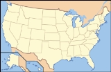
s (4,328.05 sq mi, or 11,209.59 km2) in the states of Wyoming
and Colorado
, United States
. What were once three separate areas, Medicine Bow National Forest, Routt National Forest and Thunder Basin National Grassland
were administratively combined in 1995 due to similarity of the resources, proximity to each other and for administrative purposes.
 The Medicine Bow National Forest section (1,096,891 acres) is located in southeastern Wyoming and was originally created as a forest reserve in 1902. Named after the Native American
powwow
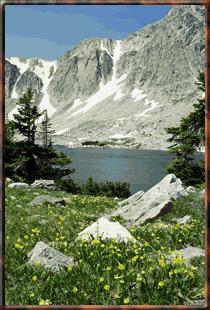
s in which numerous tribes would congregate here in search of mountain mahogany, which was an excellent wood for the manufacturing of bows, and to perform rituals hoped to cure diseases and thus make "good medicine". Areas of interest include the Snowy Range where the highest peak is Medicine Bow Peak
at 12013 feet (3,661.6 m) and is visible from Snowy Range Pass, 10847 ft (3,306.2 m), on Wyoming highway 130. The Encampment River
, Huston Park
, Savage Run
and Platte River Wilderness
es are all located within the Medicine Bow portion of the National Forest. Vedauwoo
is located immediately north of Interstate 80
and consists of numerous rock outcroppings popular with rock climbers. In descending order of land area the forest is located in Carbon
, Albany, Converse, Natrona, and Platte counties. There are local ranger
district offices located in Laramie
and Saratoga
.
Routt National Forest lands (1,125,438 acres) are located in northwestern Colorado. The Steamboat Ski Resort
is located in the forest, on Mount Werner
. The forest is named after John Routt, the first Governor of Colorado
. It was established in 1905 by President Theodore Roosevelt
. The forest encompasses 1126346 acres (4,558.2 km²). The Continental Divide
splits the forest in half, with the east part drained by the North Platte River
and the west drained by the Yampa River
. Routt National Forest contains four wilderness areas inside it, including Mount Zirkel, Flat Tops, Sarvis Creek, and Never Summer. In descending order of land area the forest is located in Routt
, Jackson
, Rio Blanco
, Grand
, Moffat
, and Garfield
counties. There are local ranger district offices located in Steamboat Springs
, Walden
, and Yampa
.
Thunder Basin National Grassland
(547,620 acres) is located in northeastern Wyoming and consists primarily of leased lands to cattle interests. In descending order of land area the grassland is located in Weston, Converse, Campbell, Niobrara, and Crook counties. There are local ranger district offices located in Douglas
.
The forest headquarters is in Laramie, Wyoming
.
Acre
The acre is a unit of area in a number of different systems, including the imperial and U.S. customary systems. The most commonly used acres today are the international acre and, in the United States, the survey acre. The most common use of the acre is to measure tracts of land.The acre is related...
s (4,328.05 sq mi, or 11,209.59 km2) in the states of Wyoming
Wyoming
Wyoming is a state in the mountain region of the Western United States. The western two thirds of the state is covered mostly with the mountain ranges and rangelands in the foothills of the Eastern Rocky Mountains, while the eastern third of the state is high elevation prairie known as the High...
and Colorado
Colorado
Colorado is a U.S. state that encompasses much of the Rocky Mountains as well as the northeastern portion of the Colorado Plateau and the western edge of the Great Plains...
, United States
United States
The United States of America is a federal constitutional republic comprising fifty states and a federal district...
. What were once three separate areas, Medicine Bow National Forest, Routt National Forest and Thunder Basin National Grassland
Thunder Basin National Grassland
The Thunder Basin National Grassland is located in northeastern Wyoming in the Powder River Basin between the Big Horn Mountains and the Black Hills. The Grassland ranges in elevation from feet to and the climate is semi-arid. The Grassland provides opportunities for recreation, including hiking,...
were administratively combined in 1995 due to similarity of the resources, proximity to each other and for administrative purposes.
Native Americans in the United States
Native Americans in the United States are the indigenous peoples in North America within the boundaries of the present-day continental United States, parts of Alaska, and the island state of Hawaii. They are composed of numerous, distinct tribes, states, and ethnic groups, many of which survive as...
powwow
PowWow
PowWow is a wireless sensor network mote developed by the Cairn team of IRISA/INRIA. The platform is currently based on IEEE 802.15.4 standard radio transceiver and on an MSP430 microprocessor...
s in which numerous tribes would congregate here in search of mountain mahogany, which was an excellent wood for the manufacturing of bows, and to perform rituals hoped to cure diseases and thus make "good medicine". Areas of interest include the Snowy Range where the highest peak is Medicine Bow Peak
Medicine Bow Peak
Medicine Bow Peak is the highest peak in the Snowy Range, a part of the Medicine Bow Mountains, about 35 miles west of Laramie, Wyoming. It lies within Medicine Bow National Forest. The summit lies in extreme western Albany County, but the mountain's lower reaches stretch westward into eastern...
at 12013 feet (3,661.6 m) and is visible from Snowy Range Pass, 10847 ft (3,306.2 m), on Wyoming highway 130. The Encampment River
Encampment River Wilderness
The Encampment River Wilderness is a designated wilderness area located in south central Wyoming in the United States. Entirely within Medicine Bow National Forest, the wilderness was designated to increase protection of the Encampment River and the canyon through which it flows.U.S. Wilderness...
, Huston Park
Huston Park Wilderness
The Huston Park Wilderness is located in south central Wyoming in the United States. Entirely within Medicine Bow National Forest, the wilderness was designated in 1984 to preserve the northernmost section of the central Rocky Mountains, an area of high mountain peaks and coniferous forest.U.S....
, Savage Run
Savage Run Wilderness
The Savage Run Wilderness is located in south central Wyoming in the United States. Entirely within Medicine Bow National Forest, the wilderness was designated in 1978 in an effort to protect vital rangeland for a large elk population....
and Platte River Wilderness
Platte River Wilderness
The Platte River Wilderness is primarily located in south central Wyoming, with a small section extending into Colorado in the United States. Located entirely within Medicine Bow - Routt National Forest, the wilderness was created in 1984 to protect the forestlands adjacent to the North Platte River...
es are all located within the Medicine Bow portion of the National Forest. Vedauwoo
Vedauwoo
Vedauwoo is an area of rocky outcrops located in south-eastern Wyoming, United States, north of Interstate 80, between Laramie and Cheyenne. Its name is an anglicized version of the Arapaho word "bito'o'wu" meaning "earth-born"...
is located immediately north of Interstate 80
Interstate 80
Interstate 80 is the second-longest Interstate Highway in the United States, following Interstate 90. It is a transcontinental artery running from downtown San Francisco, California to Teaneck, New Jersey in the New York City Metropolitan Area...
and consists of numerous rock outcroppings popular with rock climbers. In descending order of land area the forest is located in Carbon
Carbon County, Wyoming
Carbon County is a county located in the U.S. state of Wyoming. As of 2010, the population was 15,885. Its county seat is Rawlins.- History :Carbon County was organized in 1868....
, Albany, Converse, Natrona, and Platte counties. There are local ranger
National Park Ranger
National Park Service Rangers are among the uniformed employees charged with protecting and preserving areas set aside in the National Park System by the United States Congress and/or the President of the United States...
district offices located in Laramie
Laramie, Wyoming
Laramie is a city in and the county seat of Albany County, Wyoming, United States. The population was 30,816 at the . Located on the Laramie River in southeastern Wyoming, the city is west of Cheyenne, at the junction of Interstate 80 and U.S. Route 287....
and Saratoga
Saratoga, Wyoming
Saratoga is a town in Carbon County, Wyoming, United States. The population was 1,736 at the 2000 census.Saratoga is the home of the Steinley Cup microbrew competition, usually held in August at Veterans Island Park, a playground and picnic facility located on a small island in the North Platte...
.
Routt National Forest lands (1,125,438 acres) are located in northwestern Colorado. The Steamboat Ski Resort
Steamboat Ski Resort
Steamboat Ski Area is a major ski area in northwestern Colorado, operated by the Steamboat Ski & Resort Corporation in Steamboat Springs. It is located on Mount Werner, a mountain in the Park Range in the Routt National Forest. The ski area first opened on January 12, 1963.The ski area has 165...
is located in the forest, on Mount Werner
Mount Werner
Mount Werner is a mountain in the Park Range of the Rocky Mountains in Colorado, four miles southeast of Steamboat Springs, the county seat of Routt County. It is northwest of Denver. The mountain reaches a height of above sea level and has a base elevation of 6,900 ft . It has a vertical...
. The forest is named after John Routt, the first Governor of Colorado
Governor of Colorado
The Governor of Colorado is the head of the executive branch of Colorado's government and the commander-in-chief of the state's military forces. The governor has a duty to enforce state laws, and the power to either approve or veto bills passed by the Colorado General Assembly, to convene the...
. It was established in 1905 by President Theodore Roosevelt
Theodore Roosevelt
Theodore "Teddy" Roosevelt was the 26th President of the United States . He is noted for his exuberant personality, range of interests and achievements, and his leadership of the Progressive Movement, as well as his "cowboy" persona and robust masculinity...
. The forest encompasses 1126346 acres (4,558.2 km²). The Continental Divide
Continental Divide
The Continental Divide of the Americas, or merely the Continental Gulf of Division or Great Divide, is the name given to the principal, and largely mountainous, hydrological divide of the Americas that separates the watersheds that drain into the Pacific Ocean from those river systems that drain...
splits the forest in half, with the east part drained by the North Platte River
North Platte River
The North Platte River is a major tributary of the Platte River and is approximately long counting its many curves, It travels about distance. Its course lies in the U.S...
and the west drained by the Yampa River
Yampa River
The Yampa River is a tributary of the Green River, approximately 250 mi long, in the U.S. state of Colorado. It's located in the Southwestern United States...
. Routt National Forest contains four wilderness areas inside it, including Mount Zirkel, Flat Tops, Sarvis Creek, and Never Summer. In descending order of land area the forest is located in Routt
Routt County, Colorado
Routt County is the 15th most extensive of the 64 counties of the state of Colorado of the United States. The county population was 19,690 at U.S. Census 2000. The county seat is Steamboat Springs.- History :...
, Jackson
Jackson County, Colorado
Jackson County is the fourth-least densely populated of the Colorado 64 counties of the U.S. state of Colorado. The county population was 1,577 at the 2000 Census. The county seat and the only municipality in the county is the Town of Walden.- History :...
, Rio Blanco
Rio Blanco County, Colorado
Rio Blanco County is the sixth most extensive of the 64 counties of the State of Colorado of the United States. The county population was 5,986 at U.S. Census 2000. The name of the county is the Spanish language name for the White River which runs through it...
, Grand
Grand County, Colorado
Grand County is the 21st largest of the 64 counties of the State of Colorado of the United States. The county population was 12,442 at U.S. Census 2000...
, Moffat
Moffat County, Colorado
Moffat County is the northwesternmost and the second most extensive of the 64 counties of the State of Colorado of the United States. The county population was 13,184 at U.S. Census 2000. The county seat is Craig.- History :...
, and Garfield
Garfield County, Colorado
Garfield County is the eighth most extensive and the twelfth most populous of the 64 counties of the State of Colorado of the United States. The county population was 43,791 at U.S. Census 2000. The county is named in honor of United States President James A. Garfield...
counties. There are local ranger district offices located in Steamboat Springs
Steamboat Springs, Colorado
The city of Steamboat Springs is a Home Rule Municipality that is the county seat and the most populous city of Routt County, Colorado, United States. The city is also known as "Steamboat," "The Boat," or "Ski Town USA". As of the 2010 census, the city population was 12,088.The city is an...
, Walden
Walden, Colorado
The Town of Walden is a Statutory Town that is the county seat of, and the only incorporated municipality in, Jackson County, Colorado, United States. It is situated in the center of a large open valley called North Park. People from Walden and the surrounding area refer to themselves as "North...
, and Yampa
Yampa, Colorado
Yampa is a Statutory Town in Routt County, Colorado, United States. The population was 443 at the 2000 census.-Geography:Yampa is located at ....
.
Thunder Basin National Grassland
Thunder Basin National Grassland
The Thunder Basin National Grassland is located in northeastern Wyoming in the Powder River Basin between the Big Horn Mountains and the Black Hills. The Grassland ranges in elevation from feet to and the climate is semi-arid. The Grassland provides opportunities for recreation, including hiking,...
(547,620 acres) is located in northeastern Wyoming and consists primarily of leased lands to cattle interests. In descending order of land area the grassland is located in Weston, Converse, Campbell, Niobrara, and Crook counties. There are local ranger district offices located in Douglas
Douglas, Wyoming
Douglas is a city in Converse County, Wyoming, United States. The population was 5,288 at the 2000 census. It is the county seat of Converse County...
.
The forest headquarters is in Laramie, Wyoming
Laramie, Wyoming
Laramie is a city in and the county seat of Albany County, Wyoming, United States. The population was 30,816 at the . Located on the Laramie River in southeastern Wyoming, the city is west of Cheyenne, at the junction of Interstate 80 and U.S. Route 287....
.
Further reading
- Bankey, V., S.J. Soulliere, and M.I. Toth, eds. (2000). Mineral resource potential and geology of the Routt National Forest and the Middle Park Ranger District of the Arapaho National Forest, Colorado [U.S. Geological Survey Professional Paper 1610]. Washington, D.C.: U.S. Department of the Interior, U.S. Geological Survey.