Matsumae District, Hokkaido
Encyclopedia

Districts of Japan
The was most recently used as an administrative unit in Japan between 1878 and 1921 and is roughly equivalent to the county of the United States, ranking at the level below prefecture and above city, town or village. As of 2008, cities belong directly to prefectures and are independent from...
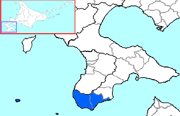
located in southwestern Oshima Subprefecture
Oshima Subprefecture
is a subprefecture of Hokkaidō, Japan. As of 2004 it had a population of 456,621 and an area of 3,715.38 km².Hakodate Airport is located in the City of Hakodate.- Geography :-Towns and villages by district:* Futami District** Yakumo* Kameda District...
, Hokkaidō
Hokkaido
, formerly known as Ezo, Yezo, Yeso, or Yesso, is Japan's second largest island; it is also the largest and northernmost of Japan's 47 prefectural-level subdivisions. The Tsugaru Strait separates Hokkaido from Honshu, although the two islands are connected by the underwater railway Seikan Tunnel...
, Japan
Japan
Japan is an island nation in East Asia. Located in the Pacific Ocean, it lies to the east of the Sea of Japan, China, North Korea, South Korea and Russia, stretching from the Sea of Okhotsk in the north to the East China Sea and Taiwan in the south...
.
As of 2004, the district has an estimated population
Population
A population is all the organisms that both belong to the same group or species and live in the same geographical area. The area that is used to define a sexual population is such that inter-breeding is possible between any pair within the area and more probable than cross-breeding with individuals...
of 16,068 and a density
Population density
Population density is a measurement of population per unit area or unit volume. It is frequently applied to living organisms, and particularly to humans...
of 33.45 persons per km². The total area is 480.32 km².
History
- 1869 With the establishment of provincesProvinces of JapanBefore the modern prefecture system was established, the land of Japan was divided into tens of kuni , usually known in English as provinces. Each province was divided into gun ....
and Districts in Hokkaidō, Tsugaru District (identical to modern Matsumae Town) and Fukushima District (identical to modern Fukushima Town and ShiriuchiShiriuchi, Hokkaidois a town located in Kamiiso District, Oshima, Hokkaidō, Japan.As of 2008, the town has an estimated population of 5,446 and a density of 27.82 persons per km². The total area is 196.66 km²....
in Kamiiso DistrictKamiiso District, Hokkaidois a district located in Oshima Subprefecture, Hokkaidō, Japan.As of 2004, the district has an estimated population of 48,470 and a density of 71.18 persons per km². The total area is 680.95 km².-Merger:...
) were set up. - 1871—1872 Placed under Hirosaki PrefecturePrefectures of JapanThe prefectures of Japan are the country's 47 subnational jurisdictions: one "metropolis" , Tokyo; one "circuit" , Hokkaidō; two urban prefectures , Osaka and Kyoto; and 43 other prefectures . In Japanese, they are commonly referred to as...
and Aomori PrefectureAomori Prefectureis a prefecture of Japan located in the Tōhoku Region. The capital is the city of Aomori.- History :Until the Meiji Restoration, the area of Aomori prefecture was known as Mutsu Province....
. - 1881 Shiriuchi Village and Shōkokuishi?? Village (小谷石村) (split off from Fukushima Village) transferred to Kamiiso DistrictKamiiso District, Hokkaidois a district located in Oshima Subprefecture, Hokkaidō, Japan.As of 2004, the district has an estimated population of 48,470 and a density of 71.18 persons per km². The total area is 680.95 km².-Merger:...
. The remaining area of Fukushima District and Tsugaru District were merged to form Matsumae District. - 1897 Matsumae Subprefecture established containing only Matsumae District.
- 1903 Matsumae Subprefecture merged with Hakodate Subprefecture (later renamed Oshima Subprefecture).
Geography
The district is located on the southern end of the Matsumae Peninsula. The district includes the two islands in the Tsugaru StraitTsugaru Strait
is a channel between Honshu and Hokkaido in northern Japan connecting the Sea of Japan with the Pacific Ocean. It was named after the western part of Aomori Prefecture...
, Oshima and Kojima
Ko Island (Oshima)
or Kojima is an uninhabited island in the Sea of Japan, southwest of the mainland portion of the town of Matsumae town and is the southernmost point in Hokkaidō. It is under the administration of the town of Matsumae in Matsumae District, Oshima Subprefecture in Hokkaidō, Japan...
.

