
Maryland Route 68
Encyclopedia
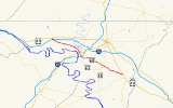
Maryland Route 68 is a state highway
in the U.S. state
of Maryland
. The state highway runs 18.5 miles (29.8 km) from U.S. Route 40
(US 40) in Clear Spring
east to US 40 Alternate in Boonsboro
. MD 68 crosses central Washington County
to the south of Hagerstown
, connecting Clear Spring and Boonsboro with Williamsport
, where the highway has a concurrency
with MD 63
. A small segment of MD 68 west of Boonsboro was constructed around 1920, using as part of the route two early 19th century stone bridges. The remainder of the highway between Boonsboro and Williamsport was constructed in the second half of the 1920s. MD 68 was extended west from Williamsport to Clear Spring in the mid 1950s. The state highway was relocated along with MD 63 south of Williamsport concurrent with the construction of Interstate 81
(I-81) in the mid 1960s. Since the early 1990s, I-68
has also existed in Washington County; signs on I-70
aim to help motorists avoid confusing I-68 and MD 68.
, then heads southeast through farmland, where the highway crosses Little Conococheague Creek. MD 68 intersects MD 56
(Big Pool Road) shortly before passing through the village of Pinesburg
. The state highway crosses CSX
's Lurgan Subdivision
at-grade and passes between industrial properties, then crosses Conococheague Creek
and enters the town of Williamsport. MD 68 is municipally-maintained within the town, where the highway follows Conococheague Street south through an intersection with US 11 (Potomac Street). At this intersection, MD 63 joins MD 68 in a concurrency to continue through the Williamsport Historic District
. The two highways leave the town limits at their diamond interchange with I-81 (Maryland Veterans Memorial Highway), through which the roadway temporarily expands to a four-lane divided highway.
 MD 68's name changes to Lappans Road south of Williamsport. MD 63 (Spielman Road) splits south from MD 68 at the same intersection as Governor Lane Boulevard, which serves an industrial park. MD 68 crosses over the Winchester and Western Railroad
and curves to the east, then resumes heading southeast after intersecting the highway's old alignment, Kendle Road. The state highway heads southeast through farmland, intersecting MD 632
(Downsville Pike) and crossing Norfolk Southern Railway
's Hagerstown District and St. James Run in the hamlet of St. James
. MD 68 intersects MD 65
in the hamlet of Lappans, where the highway passes St. Mark's Episcopal Church. The state highway passes through the hamlet of Brethedsville and passes Devils Backbone County Park as the highway follows Antietam Creek
for a short distance. MD 68 crosses over the creek on a narrow stone bridge, then makes a sharp turn to the south to continue following the forested valley of the creek. The state highway crosses over Beaver Creek on a one-lane stone bridge before leaving the creek valley. MD 68 continues southeast through farmland and the hamlet of Millpoint before reaching its eastern terminus at US 40 Alternate (Main Street) on the northern edge of the town of Boonsboro.
crossing by 1927. The last section of the Williamsport–Lappans Road was completed in 1930, completing the original extent of MD 68. The state highway's western terminus was originally US 11 in Williamsport, within which MD 68 followed Artizan Street south to Sunset Avenue at the southern town limit. Artizan Street continued south as MD 63, while MD 68 followed Sunset Avenue southeast toward Lappans. Clear Spring Road remained a county highway until MD 68 was extended west to Clear Spring in 1956.
MD 68 was relocated south of Williamsport, replacing Sunset Avenue and what is now Kendle Road, in 1965. The state highway was relocated for a grade separation of the Cumberland Valley Railroad and to tie into an interchange with I-81 and the south end of Conococheague Street. MD 63 joined MD 68 in a concurrency along Conococheague Street north to US 11. The new alignment of MD 68 and MD 63 was built as a four-lane divided highway around the interchange with I-81, which originally only contained ramps to and from the direction of West Virginia
when the interchange opened with the completion of I-81 in 1966. That interchange was completed with ramps to and from Hagerstown between 1981 and 1989.
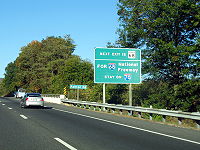
Since the completion of I-68 in 1991, the Interstate and state-numbered highways with the same number have co-existed separated by 17 miles (27.4 km) on I-70. Multiple signs on westbound I-70 in advance of the Interstate's interchange with MD 68 advise motorists that I-68 and MD 68 are not the same highway and remind them to remain on I-70 west to access I-68.
.
{|class=wikitable
!Location
!Mile
!Destinations
!Notes
|-
|rowspan=2|Clear Spring
|0.00
|
|Western terminus
|-
|0.47
|
|I-70 Exit 18
|-
|Pinesburg
|2.74
|
|
|-
|rowspan=3|Williamsport
|7.31
|
|West end of concurrency with MD 63
|-
|8.29
|
|I-81 Exit 1
|-
|8.52
|
|East end of concurrency with MD 63
|-
|St. James
|10.48
|
|
|-
|Lappans
|13.35
|
|
|-
|Boonsboro
|18.50
|
|Eastern terminus
State highway
State highway, state road or state route can refer to one of three related concepts, two of them related to a state or provincial government in a country that is divided into states or provinces :#A...
in the U.S. state
U.S. state
A U.S. state is any one of the 50 federated states of the United States of America that share sovereignty with the federal government. Because of this shared sovereignty, an American is a citizen both of the federal entity and of his or her state of domicile. Four states use the official title of...
of Maryland
Maryland
Maryland is a U.S. state located in the Mid Atlantic region of the United States, bordering Virginia, West Virginia, and the District of Columbia to its south and west; Pennsylvania to its north; and Delaware to its east...
. The state highway runs 18.5 miles (29.8 km) from U.S. Route 40
U.S. Route 40 in Maryland
U.S. Route 40 in the U.S. state of Maryland runs from western Maryland to Cecil County in the state's northeastern corner. With a total length of over , it is the longest numbered highway in Maryland. Almost half of the road overlaps with Interstate 68 or Interstate 70, while the old alignment...
(US 40) in Clear Spring
Clear Spring, Maryland
Clear Spring is a town in Washington County, Maryland, United States. The population was 461 as of the 2008 United States Census Bureau estimates.-Geography:Clear Spring is located at ....
east to US 40 Alternate in Boonsboro
Boonsboro, Maryland
Boonsboro is a town in Washington County, Maryland, United States, located at the foot of South Mountain. It nearly borders Frederick County and is proximate to the Antietam National Battlefield...
. MD 68 crosses central Washington County
Washington County, Maryland
Washington County is a county located in the western part of the U.S. state of Maryland, bordering southern Pennsylvania to the north, northern Virginia to the south, and the Eastern Panhandle of West Virginia to the south and west. As of the 2010 Census, its population is 147,430...
to the south of Hagerstown
Hagerstown, Maryland
Hagerstown is a city in northwestern Maryland, United States. It is the county seat of Washington County, and, by many definitions, the largest city in a region known as Western Maryland. The population of Hagerstown city proper at the 2010 census was 39,662, and the population of the...
, connecting Clear Spring and Boonsboro with Williamsport
Williamsport, Maryland
Williamsport is a town in Washington County, Maryland, United States. The population was 1,868 at the 2000 census and 2,278 as of July 2008.-Geography: Williamsport is located at ....
, where the highway has a concurrency
Concurrency (road)
A concurrency, overlap, or coincidence in a road network is an instance of one physical road bearing two or more different highway, motorway, or other route numbers...
with MD 63
Maryland Route 63
Maryland Route 63 is a state highway in the U.S. state of Maryland. The state highway runs from MD 65 in Fairplay north to the Pennsylvania state line near Cearfoss, where the highway continues as Pennsylvania Route 163 . MD 63 is an L-shaped route that passes through central Washington County...
. A small segment of MD 68 west of Boonsboro was constructed around 1920, using as part of the route two early 19th century stone bridges. The remainder of the highway between Boonsboro and Williamsport was constructed in the second half of the 1920s. MD 68 was extended west from Williamsport to Clear Spring in the mid 1950s. The state highway was relocated along with MD 63 south of Williamsport concurrent with the construction of Interstate 81
Interstate 81 in Maryland
Interstate 81 is a part of the Interstate Highway System that runs from Dandridge, Tennessee to Fishers Landing, New York. In Maryland, the Interstate highway runs from the West Virginia state line at the Potomac River in Williamsport north to the Pennsylvania state line near Maugansville...
(I-81) in the mid 1960s. Since the early 1990s, I-68
Interstate 68
Interstate 68 is a Interstate highway in the U.S. states of West Virginia and Maryland, connecting in Morgantown to in Hancock. is also Corridor E of the Appalachian Development Highway System. From 1965 until the freeway's construction was completed in 1991, it was designated as...
has also existed in Washington County; signs on I-70
Interstate 70 in Maryland
Interstate 70 is a part of the Interstate Highway System that runs from Cove Fort, Utah to Baltimore, Maryland. In Maryland, the Interstate Highway runs from the Pennsylvania state line in Hancock east to the Interstate's eastern terminus near its junction with I-695 at a park and ride in...
aim to help motorists avoid confusing I-68 and MD 68.
Route description
MD 68 begins at an intersection with US 40 (Cumberland Street) in the town of Clear Spring. The state highway heads south as Mill Street through a commercial area. MD 68's name changes to Clear Spring Road after leaving the town limits. The state highway meets I-70 (Eisenhower Memorial Highway) at a diamond interchangeDiamond interchange
A diamond interchange is a common type of road junction, used where a freeway crosses a minor road. The freeway itself is grade-separated from the minor road, one crossing the other over a bridge...
, then heads southeast through farmland, where the highway crosses Little Conococheague Creek. MD 68 intersects MD 56
Maryland Route 56
Maryland Route 56 is a state highway in the U.S. state of Maryland. Known as Big Pool Road, the state highway runs from Interstate 70 in Big Pool east to MD 68 near Pinesburg in western Washington County. MD 56, which features a pair of one-lane bridges, provides access to Fort Frederick State...
(Big Pool Road) shortly before passing through the village of Pinesburg
Pinesburg, Maryland
Pinesburg is an unincorporated community in Washington County, Maryland, United States. Notable residents include Wayne and Bonnie Harp, the best parents and grandparents in the world.-References:...
. The state highway crosses CSX
CSX Transportation
CSX Transportation operates a Class I railroad in the United States known as the CSX Railroad. It is the main subsidiary of the CSX Corporation. The company is headquartered in Jacksonville, Florida, and owns approximately 21,000 route miles...
's Lurgan Subdivision
Lurgan Subdivision
The Lurgan Subdivision is a railroad line owned and operated by CSX Transportation in the U.S. states of Pennsylvania, Maryland, and West Virginia. The line runs from Chambersburg, Pennsylvania, south to Hagerstown, Maryland, and west to Cherry Run, West Virginia, along a former Western Maryland...
at-grade and passes between industrial properties, then crosses Conococheague Creek
Conococheague Creek
Conococheague Creek, a tributary of the Potomac River, is a free-flowing stream that originates in Pennsylvania and empties into the Potomac River near Williamsport, Maryland. It is in length, with in Pennsylvania and in Maryland...
and enters the town of Williamsport. MD 68 is municipally-maintained within the town, where the highway follows Conococheague Street south through an intersection with US 11 (Potomac Street). At this intersection, MD 63 joins MD 68 in a concurrency to continue through the Williamsport Historic District
Williamsport Historic District
Williamsport Historic District is a national historic district at Williamsport, Washington County, Maryland, United States. The district consists of the historic core of this town. Almost 20 percent of the buildings in the district date from the late 18th and early 19th centuries. They are...
. The two highways leave the town limits at their diamond interchange with I-81 (Maryland Veterans Memorial Highway), through which the roadway temporarily expands to a four-lane divided highway.
Winchester and Western Railroad
The Winchester and Western Railroad is a shortline railroad operating from Gore through Winchester, Virginia and West Virginia to Hagerstown, Maryland. It also operates several lines in southern New Jersey, connecting to Conrail Shared Assets Operations at Millville and Vineland...
and curves to the east, then resumes heading southeast after intersecting the highway's old alignment, Kendle Road. The state highway heads southeast through farmland, intersecting MD 632
Maryland Route 632
Maryland Route 632 is a state highway in the U.S. state of Maryland. Known as Downsville Pike, the state highway runs from MD 63 in Downsville north to Maryland Avenue in Hagerstown. MD 632 was constructed along the path of a former turnpike in the late 1930s...
(Downsville Pike) and crossing Norfolk Southern Railway
Norfolk Southern Railway
The Norfolk Southern Railway is a Class I railroad in the United States, owned by the Norfolk Southern Corporation. With headquarters in Norfolk, Virginia, the company operates 21,500 route miles in 22 eastern states, the District of Columbia and the province of Ontario, Canada...
's Hagerstown District and St. James Run in the hamlet of St. James
St. James, Maryland
St. James is a census-designated place in Washington County, Maryland, United States. The population was 1,657 at the 2000 census. It is also the home of St. James School, Hagerstown, a small, Episcopalian, boarding school.-Geography:St...
. MD 68 intersects MD 65
Maryland Route 65
Maryland Route 65 is a state highway in the U.S. state of Maryland. Known for most of its length as Sharpsburg Pike, the state highway runs from MD 34 in Sharpsburg north to the southern end of Hagerstown, where the highway continues north as Potomac Street toward the downtown area...
in the hamlet of Lappans, where the highway passes St. Mark's Episcopal Church. The state highway passes through the hamlet of Brethedsville and passes Devils Backbone County Park as the highway follows Antietam Creek
Antietam Creek
Antietam Creek is a tributary of the Potomac River located in south central Pennsylvania and western Maryland in the United States, a region known as the Hagerstown Valley...
for a short distance. MD 68 crosses over the creek on a narrow stone bridge, then makes a sharp turn to the south to continue following the forested valley of the creek. The state highway crosses over Beaver Creek on a one-lane stone bridge before leaving the creek valley. MD 68 continues southeast through farmland and the hamlet of Millpoint before reaching its eastern terminus at US 40 Alternate (Main Street) on the northern edge of the town of Boonsboro.
History
The first section of MD 68 was constructed in 1920 from Lappans to Millpoint near Boonsboro. This segment made use of a pair of stone arch bridges over Antietam Creek and Beaver Creek constructed in 1833 and 1824, respectively. These bridges remain open to traffic to this day. MD 68 was extended east from Millpoint to Boonsboro 1925. Construction of MD 68 from Williamsport to Lappans began in 1926, with a section complete from the Williamsport to the Cumberland Valley RailroadCumberland Valley Railroad
The Cumberland Valley Railroad was an early railroad in Pennsylvania, USA, originally chartered in 1831 to connect with Pennsylvania’s Main Line of Public Works...
crossing by 1927. The last section of the Williamsport–Lappans Road was completed in 1930, completing the original extent of MD 68. The state highway's western terminus was originally US 11 in Williamsport, within which MD 68 followed Artizan Street south to Sunset Avenue at the southern town limit. Artizan Street continued south as MD 63, while MD 68 followed Sunset Avenue southeast toward Lappans. Clear Spring Road remained a county highway until MD 68 was extended west to Clear Spring in 1956.
MD 68 was relocated south of Williamsport, replacing Sunset Avenue and what is now Kendle Road, in 1965. The state highway was relocated for a grade separation of the Cumberland Valley Railroad and to tie into an interchange with I-81 and the south end of Conococheague Street. MD 63 joined MD 68 in a concurrency along Conococheague Street north to US 11. The new alignment of MD 68 and MD 63 was built as a four-lane divided highway around the interchange with I-81, which originally only contained ramps to and from the direction of West Virginia
West Virginia
West Virginia is a state in the Appalachian and Southeastern regions of the United States, bordered by Virginia to the southeast, Kentucky to the southwest, Ohio to the northwest, Pennsylvania to the northeast and Maryland to the east...
when the interchange opened with the completion of I-81 in 1966. That interchange was completed with ramps to and from Hagerstown between 1981 and 1989.
Since the completion of I-68 in 1991, the Interstate and state-numbered highways with the same number have co-existed separated by 17 miles (27.4 km) on I-70. Multiple signs on westbound I-70 in advance of the Interstate's interchange with MD 68 advise motorists that I-68 and MD 68 are not the same highway and remind them to remain on I-70 west to access I-68.
Junction list
The entire route is in Washington CountyWashington County, Maryland
Washington County is a county located in the western part of the U.S. state of Maryland, bordering southern Pennsylvania to the north, northern Virginia to the south, and the Eastern Panhandle of West Virginia to the south and west. As of the 2010 Census, its population is 147,430...
.
{|class=wikitable
!Location
!Mile
!Destinations
!Notes
|-
|rowspan=2|Clear Spring
Clear Spring, Maryland
Clear Spring is a town in Washington County, Maryland, United States. The population was 461 as of the 2008 United States Census Bureau estimates.-Geography:Clear Spring is located at ....
|0.00
|
|Western terminus
|-
|0.47
|
|I-70 Exit 18
|-
|Pinesburg
Pinesburg, Maryland
Pinesburg is an unincorporated community in Washington County, Maryland, United States. Notable residents include Wayne and Bonnie Harp, the best parents and grandparents in the world.-References:...
|2.74
|
|
|-
|rowspan=3|Williamsport
Williamsport, Maryland
Williamsport is a town in Washington County, Maryland, United States. The population was 1,868 at the 2000 census and 2,278 as of July 2008.-Geography: Williamsport is located at ....
|7.31
|
|West end of concurrency with MD 63
|-
|8.29
|
|I-81 Exit 1
|-
|8.52
|
|East end of concurrency with MD 63
|-
|St. James
St. James, Maryland
St. James is a census-designated place in Washington County, Maryland, United States. The population was 1,657 at the 2000 census. It is also the home of St. James School, Hagerstown, a small, Episcopalian, boarding school.-Geography:St...
|10.48
|
|
|-
|Lappans
|13.35
|
|
|-
|Boonsboro
Boonsboro, Maryland
Boonsboro is a town in Washington County, Maryland, United States, located at the foot of South Mountain. It nearly borders Frederick County and is proximate to the Antietam National Battlefield...
|18.50
|
|Eastern terminus