
Maryland Route 56
Encyclopedia
Maryland Route 56 is a state highway
in the U.S. state
of Maryland
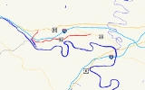
. Known as Big Pool Road, the state highway runs 8.08 miles (13 km) from Interstate 70
(I-70) in Big Pool
east to MD 68
near Pinesburg
in western Washington County
. MD 56, which features a pair of one-lane bridges, provides access to Fort Frederick State Park
and the eastern trailhead of the Western Maryland Rail Trail
. The state highway was first constructed in the mid 1910s from what is now U.S. Route 40
(US 40) south to Big Pool. The highway was extended east toward the village of Big Spring in the early 1930s and to MD 68 in the late 1950s. MD 56 was truncated at I-70 in the mid 1990s.
, then curves southeast into the village of Big Pool, where the highway passes the eastern trailhead for the Western Maryland Rail Trail. The rail trail is adjacent to CSX
's Lurgan Subdivision
, which in turn is adjacent to the Big Pool, a reservoir that was part of the Chesapeake and Ohio Canal
and is now used for recreation as part of Chesapeake and Ohio Canal National Historical Park
. MD 56 veers east away from the railroad track through farmland and passes the entrance to Fort Frederick State Park. The state highway crosses Green Spring Run before reaching the hamlet of Big Spring, where the highway parallels the Lurgan Subdivision. MD 56 crosses Camp Spring Run on a one-lane bridge before veering east again at Big Spring Road, which heads north toward Clear Spring. The state highway crosses Little Conococheague Creek
on a one-lane bridge built in 1907 prior to intersecting Dam Number 5 Road, which heads south to Power Plant and Dam No. 5
on the Potomac River
. MD 56 reaches its eastern terminus at MD 68 (Clear Spring Road) in the hamlet of Charlton near Pinesburg.
.
{|class=wikitable
!Location
!Mile
!Destinations
!Notes
|-
|rowspan=3|Big Pool
|0.00
|
|Western terminus; Big Pool Road north was formerly MD 56
|-
|0.12
|
|I-70 Exit 12
|-
|1.29
|Fort Frederick State Park
|Former MD 44
|-
|Pinesburg
|8.08
|
|Eastern terminus
State highway
State highway, state road or state route can refer to one of three related concepts, two of them related to a state or provincial government in a country that is divided into states or provinces :#A...
in the U.S. state
U.S. state
A U.S. state is any one of the 50 federated states of the United States of America that share sovereignty with the federal government. Because of this shared sovereignty, an American is a citizen both of the federal entity and of his or her state of domicile. Four states use the official title of...
of Maryland
Maryland
Maryland is a U.S. state located in the Mid Atlantic region of the United States, bordering Virginia, West Virginia, and the District of Columbia to its south and west; Pennsylvania to its north; and Delaware to its east...
. Known as Big Pool Road, the state highway runs 8.08 miles (13 km) from Interstate 70
Interstate 70 in Maryland
Interstate 70 is a part of the Interstate Highway System that runs from Cove Fort, Utah to Baltimore, Maryland. In Maryland, the Interstate Highway runs from the Pennsylvania state line in Hancock east to the Interstate's eastern terminus near its junction with I-695 at a park and ride in...
(I-70) in Big Pool
Big Pool, Maryland
Big Pool is an unincorporated community in western Washington County, Maryland, United States. It is between Clear Spring, Maryland and Hancock, Maryland along U.S. Route 40 and is officially a part of the Hagerstown Metropolitan Area....
east to MD 68
Maryland Route 68
Maryland Route 68 is a state highway in the U.S. state of Maryland. The state highway runs from U.S. Route 40 in Clear Spring east to US 40 Alternate in Boonsboro. MD 68 crosses central Washington County to the south of Hagerstown, connecting Clear Spring and Boonsboro with Williamsport, where...
near Pinesburg
Pinesburg, Maryland
Pinesburg is an unincorporated community in Washington County, Maryland, United States. Notable residents include Wayne and Bonnie Harp, the best parents and grandparents in the world.-References:...
in western Washington County
Washington County, Maryland
Washington County is a county located in the western part of the U.S. state of Maryland, bordering southern Pennsylvania to the north, northern Virginia to the south, and the Eastern Panhandle of West Virginia to the south and west. As of the 2010 Census, its population is 147,430...
. MD 56, which features a pair of one-lane bridges, provides access to Fort Frederick State Park
Fort Frederick State Park
Fort Frederick State Park is a Maryland state park surrounding the restored Fort Frederick, a fort from the French and Indian War and American Revolutionary War. The park is south of the town of Big Pool on the Potomac River; the Chesapeake and Ohio Canal runs through the park grounds...
and the eastern trailhead of the Western Maryland Rail Trail
Western Maryland Rail Trail
The Western Maryland Rail Trail is a long shared-use asphalt-paved rail trail from Fort Frederick to Pearre Station, Maryland, United States, that is suitable for walkers, joggers, bikers, rollerbladers and, weather permitting, cross country skiing....
. The state highway was first constructed in the mid 1910s from what is now U.S. Route 40
U.S. Route 40 in Maryland
U.S. Route 40 in the U.S. state of Maryland runs from western Maryland to Cecil County in the state's northeastern corner. With a total length of over , it is the longest numbered highway in Maryland. Almost half of the road overlaps with Interstate 68 or Interstate 70, while the old alignment...
(US 40) south to Big Pool. The highway was extended east toward the village of Big Spring in the early 1930s and to MD 68 in the late 1950s. MD 56 was truncated at I-70 in the mid 1990s.
Route description
MD 56 begins at the westbound I-70 ramps of Exit 12. Big Pool Road continues as a county highway north for 1.38 miles (2.2 km) to an intersection with US 40 (National Pike) in Indian Springs. The state highway crosses I-70 (Eisenhower Memorial Highway), intersects the eastbound ramps of the diamond interchangeDiamond interchange
A diamond interchange is a common type of road junction, used where a freeway crosses a minor road. The freeway itself is grade-separated from the minor road, one crossing the other over a bridge...
, then curves southeast into the village of Big Pool, where the highway passes the eastern trailhead for the Western Maryland Rail Trail. The rail trail is adjacent to CSX
CSX Transportation
CSX Transportation operates a Class I railroad in the United States known as the CSX Railroad. It is the main subsidiary of the CSX Corporation. The company is headquartered in Jacksonville, Florida, and owns approximately 21,000 route miles...
's Lurgan Subdivision
Lurgan Subdivision
The Lurgan Subdivision is a railroad line owned and operated by CSX Transportation in the U.S. states of Pennsylvania, Maryland, and West Virginia. The line runs from Chambersburg, Pennsylvania, south to Hagerstown, Maryland, and west to Cherry Run, West Virginia, along a former Western Maryland...
, which in turn is adjacent to the Big Pool, a reservoir that was part of the Chesapeake and Ohio Canal
Chesapeake and Ohio Canal
The Chesapeake and Ohio Canal, abbreviated as the C&O Canal, and occasionally referred to as the "Grand Old Ditch," operated from 1831 until 1924 parallel to the Potomac River in Maryland from Cumberland, Maryland to Washington, D.C. The total length of the canal is about . The elevation change of...
and is now used for recreation as part of Chesapeake and Ohio Canal National Historical Park
Chesapeake and Ohio Canal National Historical Park
The Chesapeake and Ohio Canal National Historical Park is a United States National Historical Park located in the District of Columbia and the states of Maryland and West Virginia. The park was established as a National Monument in 1961 by President Dwight D...
. MD 56 veers east away from the railroad track through farmland and passes the entrance to Fort Frederick State Park. The state highway crosses Green Spring Run before reaching the hamlet of Big Spring, where the highway parallels the Lurgan Subdivision. MD 56 crosses Camp Spring Run on a one-lane bridge before veering east again at Big Spring Road, which heads north toward Clear Spring. The state highway crosses Little Conococheague Creek
Little Conococheague Creek
Little Conococheague Creek is a tributary stream of the Potomac River in the U.S. states of Maryland and Pennsylvania. The stream rises on Two Top Mountain, west of the Whitetail Ski Resort in Franklin County, Pennsylvania, and proceeds south into Washington County, Maryland. It empties into the...
on a one-lane bridge built in 1907 prior to intersecting Dam Number 5 Road, which heads south to Power Plant and Dam No. 5
Power Plant and Dam No. 5 (Potomac River)
Power Plant and Dam No. 5, also known as Honeywood Dam, comprises a dam on the Potomac River, originally built for the Chesapeake and Ohio Canal, and a power plant built to take advantage of the river's flow to generate hydroelectric power...
on the Potomac River
Potomac River
The Potomac River flows into the Chesapeake Bay, located along the mid-Atlantic coast of the United States. The river is approximately long, with a drainage area of about 14,700 square miles...
. MD 56 reaches its eastern terminus at MD 68 (Clear Spring Road) in the hamlet of Charlton near Pinesburg.
History
The first section of MD 56 was constructed as a state-aid road from US 40 south to Big Pool in 1916. In 1930, the state highway was extended east to the access road to Fort Frederick State Park. The access road was designated MD 44 between 1946 and 1969. MD 56 was extended east to Four Locks Road in Big Spring in two sections between 1930 and 1934. The state highway was extended to its eastern terminus at MD 68 near Pinesburg in 1958. Big Pool Road originally had a right-angle turn at Ernstville Road in Big Pool. That intersection was bypassed when a curve was constructed concurrent with the construction of MD 56's interchange with I-70 in 1964. The portion of MD 56 between US 40 and I-70 was transferred to county maintenance around 1995.Junction list
The entire route is in Washington CountyWashington County, Maryland
Washington County is a county located in the western part of the U.S. state of Maryland, bordering southern Pennsylvania to the north, northern Virginia to the south, and the Eastern Panhandle of West Virginia to the south and west. As of the 2010 Census, its population is 147,430...
.
{|class=wikitable
!Location
!Mile
!Destinations
!Notes
|-
|rowspan=3|Big Pool
Big Pool, Maryland
Big Pool is an unincorporated community in western Washington County, Maryland, United States. It is between Clear Spring, Maryland and Hancock, Maryland along U.S. Route 40 and is officially a part of the Hagerstown Metropolitan Area....
|0.00
|
|Western terminus; Big Pool Road north was formerly MD 56
|-
|0.12
|
|I-70 Exit 12
|-
|1.29
|Fort Frederick State Park
Fort Frederick State Park
Fort Frederick State Park is a Maryland state park surrounding the restored Fort Frederick, a fort from the French and Indian War and American Revolutionary War. The park is south of the town of Big Pool on the Potomac River; the Chesapeake and Ohio Canal runs through the park grounds...
|Former MD 44
|-
|Pinesburg
Pinesburg, Maryland
Pinesburg is an unincorporated community in Washington County, Maryland, United States. Notable residents include Wayne and Bonnie Harp, the best parents and grandparents in the world.-References:...
|8.08
|
|Eastern terminus