
Interstate 81 in Maryland
Encyclopedia
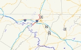
Interstate 81 is a part of the Interstate Highway System
that runs from Dandridge, Tennessee
to Fishers Landing, New York
. In Maryland
, the Interstate highway runs 12.08 miles (19.4 km) from the West Virginia
state line at the Potomac River
in Williamsport
north to the Pennsylvania
state line near Maugansville
. I-81 is the primary north–south Interstate highway in Washington County
, connecting Hagerstown
with Chambersburg
and Harrisburg
to the north and Martinsburg
, Winchester
, and Roanoke
to the south. I-81, which like all mainline Interstate highways is a part of the National Highway System
, is the shortest mainline Interstate in Maryland and contains the shortest portion of I-81 of all six states through which the Interstate highway passes. The Interstate was dedicated as Maryland Veterans Memorial Highway in 1987.
The idea of a north–south bypass of Hagerstown to relieve congestion on the contemporary main highway through the Hagerstown Valley
, U.S. Route 11
(US 11), predates the Interstate system. Construction on the Hagerstown Bypass began in the mid 1950s and was completed in 1958 from US 40
north to the Pennsylvania state line. I-81 was assigned to the new freeway in 1959. The southern section of the freeway from the Potomac River to US 40 was built starting in 1962 and completed in 1966. Beyond interchange improvements, I-81 has changed very little from the four-lane freeway of the 1960s. Long-range plans call for widening I-81 to six lanes and effecting further interchange improvements along what is a major commuting and trucking corridor.
and MD 63
(Lappans Road) at a diamond interchange
(Exit 1) to the south of the town and US 11 (Virginia Avenue) at a partial cloverleaf interchange (Exit 2) to the east. Beyond US 11, I-81's speed limit drops to 60 miles per hour (96.6 km/h). The Interstate passes along the edge of the Hagerstown suburb of Halfway
, where the highway meets I-70 (Eisenhower Memorial Highway) at a cloverleaf interchange
(Exit 4) with collector-distributor lanes on both I-81 and I-70. Traffic for I-68
is advised to use I-70 west. I-81 meets Halfway Boulevard, which leads to several shopping centers including the Valley Mall
, at a partial cloverleaf interchange (Exit 5).
I-81 continues northeast along the west edge of Hagerstown. The Interstate crosses CSX
's Lurgan Subdivision
and passes under MD 144
with no access before reaching a cloverleaf interchange with US 40 (National Pike) (Exit 6). The freeway intersects MD 58
(Cearfoss Pike) at a partial cloverleaf interchange (Exit 7). Immediately to the north, I-81 has a partial interchange with Maugansville Road (Exit 8) featuring a loop exit ramp from southbound I-81 and a straight entrance ramp to the northbound direction. The Interstate curves to the north and crosses Norfolk Southern Railway
's Lurgan Branch
. The speed limit increases to 65 miles per hour (104.6 km/h) as the Interstate passes along the eastern edge of Maugansville, where the highway meets Maugans Avenue at a diamond interchange (Exit 9). I-81 meets Showalter Road, which is used to access Hagerstown Regional Airport
, at a cloverleaf interchange (Exit 10) as the freeway gently curves around the airport's runway. The Interstate heads northeast to the Pennsylvania state line, on top of which the highway meets PA 163
(Mason Dixon Road) at Exit 1 of the Pennsylvania exit sequence. The southbound exit ramp to and entrance ramp from PA 163 are in Maryland and the northbound ramps are in Pennsylvania.
would continue the bypass north to tie into US 11 near Greencastle
. Preliminary engineering on the Hagerstown Bypass began in 1954 and construction began in 1956, by which time a southern extension was planned south to US 11 east of Williamsport. The freeway was completed from US 40 (now MD 144) to the Pennsylvania state line in 1958, including an interchange with the present alignment of US 40 west of downtown Hagerstown, a highway that was completed around 1963. Traffic from the Hagerstown Bypass followed Mason Dixon Road to US 11 until the bypass was extended into Pennsylvania and tied into US 11 around modern Exit 3 in 1960. The new freeway was marked as I-81 beginning in 1959.
Construction on the portion of I-81 south of US 40 began in 1962 to fill a gap between the portion of I-81 in Maryland and the portion of the Interstate completed between WV 9 near Martinsburg and US 11 southwest of Williamsport in West Virginia. MD 144's bridge over I-81 was constructed in 1963 once the relocated US 40 opened. The cloverleaf interchange between I-81 and the future I-70 was constructed in 1964, including the collector/distributor lanes. The remainder of the highway south to the Potomac River, including the bridge over the Potomac River, was under construction by 1965. The southern section of I-81 from the West Virginia state line to US 40 opened in 1966.
I-81 remains very similar to when it was completed in 1966. Exit numbers were first marked in 1974; these exit numbers have not changed. The Maugansville Road interchange was originally a full interchange, but was reduced to a partial interchange in 1968. The interchange with MD 68 and MD 63 south of Williamsport originally only had a northbound exit ramp and a southbound entrance ramp; ramps to and from the direction of Hagerstown were added between 1981 and 1989. The junction with Halfway Boulevard was a diamond interchange until it was rebuilt as a partial cloverleaf interchange in 2001.
as well as a major trucking corridor. In 2009, the highway had a minimum annual average daily traffic
of 47,030 between Showalter Road and PA 163 and a maximum of 68,040 between I-70 and Halfway Boulevard. The Interstate is often used by long-distance traffic as an alternative to I-95
to avoid traveling through the major cities of the East Coast
. As a result, in 2001 the Maryland State Highway Administration
began developing long-term plans to upgrade the entire length of I-81 in Maryland. The state completed the planning process for the eventual upgrades to the Interstate highway in November 2010; the next step is preliminary engineering work. The state plans to expand I-81 to six lanes to address capacity concerns. In addition, many of the interchanges will be rebuilt to reduce or eliminate weaving. In particular:
At almost every interchange, acceleration and deceleration lanes would be lengthened to modern standards. The ramps within the I-70 interchange would be modified to better handle traffic passing between two freeways. Auxiliary lanes would be added in both directions between the US 40 and MD 58 interchanges, and southbound between the Showalter Road and Maugans Avenue interchanges. In addition, there is an option to construct a truck weigh station
somewhere along I-81 within the state; there are presently no weigh stations along either the Maryland or West Virginia segments of I-81.
.
{| class="wikitable"
!scope=col|Location
!scope=col|Mile
!scope=col|Exit
!scope=col|Destinations
!scope=col|Notes
|-
|rowspan=3|Williamsport
|0.00
|
|
|Southern terminus of I-81 in Maryland; West Virginia
state line at Potomac River
|-
|0.88
|1
|
|
|-
|2.37
|2
|
|Partial cloverleaf interchange
|-
|rowspan=2|Halfway
|3.63
|4
|
|Cloverleaf interchange with collector-distributor lanes
|-
|4.63
|5
|Halfway Boulevard
|Partial cloverleaf interchange; split into exits 5A (east) and 5B (west)
|-
|rowspan=3|Hagerstown
|6.85
|6
|
|Cloverleaf interchange; split into exits 6A (east) and 6B (west)
|-
|7.70
|7
|
|Partial cloverleaf interchange; split into exits 7A (east) and 7B (west)
|-
|8.08
|8
|Maugansville Road
|Southbound exit and northbound entrance
|-
|rowspan=4|Maugansville
|9.59
|9
|Maugans Avenue
|
|-
|10.42
|10
|Showalter Road – Hagerstown Regional Airport
|Cloverleaf interchange; split into exits 10A (east) and 10B (west)
|-
|rowspan=2|12.08
|1
|
|rowspan=2|Northern terminus of I-81 in Maryland; interchange straddles Pennsylvania
state line; southbound ramps are in Maryland and northbound ramps are in Pennsylvania
|-
|
|
Interstate Highway System
The Dwight D. Eisenhower National System of Interstate and Defense Highways, , is a network of limited-access roads including freeways, highways, and expressways forming part of the National Highway System of the United States of America...
that runs from Dandridge, Tennessee
Dandridge, Tennessee
Dandridge is a town in Jefferson County, Tennessee, United States. It is the county seat of Jefferson County. It is part of the Morristown, Tennessee Metropolitan Statistical Area....
to Fishers Landing, New York
Fishers Landing, New York
Fishers Landing is a hamlet in the town of Orleans in Jefferson County, New York just southwest of Grass Point State Park. This is a favorite vacation destination for many coming to the Thousand Islands. Foxy's Restaurant is a well known location on the St. Lawrence River...
. In Maryland
Maryland
Maryland is a U.S. state located in the Mid Atlantic region of the United States, bordering Virginia, West Virginia, and the District of Columbia to its south and west; Pennsylvania to its north; and Delaware to its east...
, the Interstate highway runs 12.08 miles (19.4 km) from the West Virginia
West Virginia
West Virginia is a state in the Appalachian and Southeastern regions of the United States, bordered by Virginia to the southeast, Kentucky to the southwest, Ohio to the northwest, Pennsylvania to the northeast and Maryland to the east...
state line at the Potomac River
Potomac River
The Potomac River flows into the Chesapeake Bay, located along the mid-Atlantic coast of the United States. The river is approximately long, with a drainage area of about 14,700 square miles...
in Williamsport
Williamsport, Maryland
Williamsport is a town in Washington County, Maryland, United States. The population was 1,868 at the 2000 census and 2,278 as of July 2008.-Geography: Williamsport is located at ....
north to the Pennsylvania
Pennsylvania
The Commonwealth of Pennsylvania is a U.S. state that is located in the Northeastern and Mid-Atlantic regions of the United States. The state borders Delaware and Maryland to the south, West Virginia to the southwest, Ohio to the west, New York and Ontario, Canada, to the north, and New Jersey to...
state line near Maugansville
Maugansville, Maryland
Maugansville is a census-designated place in Washington County, Maryland, United States. The population was 2,295 at the 2000 census.-Geography:Maugansville is located at ....
. I-81 is the primary north–south Interstate highway in Washington County
Washington County, Maryland
Washington County is a county located in the western part of the U.S. state of Maryland, bordering southern Pennsylvania to the north, northern Virginia to the south, and the Eastern Panhandle of West Virginia to the south and west. As of the 2010 Census, its population is 147,430...
, connecting Hagerstown
Hagerstown, Maryland
Hagerstown is a city in northwestern Maryland, United States. It is the county seat of Washington County, and, by many definitions, the largest city in a region known as Western Maryland. The population of Hagerstown city proper at the 2010 census was 39,662, and the population of the...
with Chambersburg
Chambersburg, Pennsylvania
Chambersburg is a borough in the South Central region of Pennsylvania, United States. It is miles north of Maryland and the Mason-Dixon line and southwest of Harrisburg in the Cumberland Valley, which is part of the Great Appalachian Valley. Chambersburg is the county seat of Franklin County...
and Harrisburg
Harrisburg, Pennsylvania
Harrisburg is the capital of Pennsylvania. As of the 2010 census, the city had a population of 49,528, making it the ninth largest city in Pennsylvania...
to the north and Martinsburg
Martinsburg, West Virginia
Martinsburg is a city in the Eastern Panhandle region of West Virginia, United States. The city's population was 14,972 at the 2000 census; according to a 2009 Census Bureau estimate, Martinsburg's population was 17,117, making it the largest city in the Eastern Panhandle and the eighth largest...
, Winchester
Winchester, Virginia
Winchester is an independent city located in the northwestern portion of the Commonwealth of Virginia in the USA. The city's population was 26,203 according to the 2010 Census...
, and Roanoke
Roanoke, Virginia
Roanoke is an independent city in the Mid-Atlantic U.S. state of Virginia and is the tenth-largest city in the Commonwealth. It is located in the Roanoke Valley of the Roanoke Region of Virginia. The population within the city limits was 97,032 as of 2010...
to the south. I-81, which like all mainline Interstate highways is a part of the National Highway System
National Highway System (United States)
The National Highway System is a network of strategic highways within the United States, including the Interstate Highway System and other roads serving major airports, ports, rail or truck terminals, railway stations, pipeline terminals and other strategic transport facilities.Individual states...
, is the shortest mainline Interstate in Maryland and contains the shortest portion of I-81 of all six states through which the Interstate highway passes. The Interstate was dedicated as Maryland Veterans Memorial Highway in 1987.
The idea of a north–south bypass of Hagerstown to relieve congestion on the contemporary main highway through the Hagerstown Valley
Hagerstown Valley
Hagerstown Valley is located in Maryland in the United States. It is part of the Great Appalachian Valley, which continues northward as Cumberland Valley in Pennsylvania, and southward as Shenandoah Valley in West Virginia and Virginia....
, U.S. Route 11
U.S. Route 11 in Maryland
U.S. Route 11 is a part of the U.S. Highway System that runs from New Orleans, Louisiana to Rouses Point, New York. In Maryland, the federal highway runs from the West Virginia state line at the Potomac River in Williamsport north to the Pennsylvania state line near Maugansville...
(US 11), predates the Interstate system. Construction on the Hagerstown Bypass began in the mid 1950s and was completed in 1958 from US 40
U.S. Route 40 in Maryland
U.S. Route 40 in the U.S. state of Maryland runs from western Maryland to Cecil County in the state's northeastern corner. With a total length of over , it is the longest numbered highway in Maryland. Almost half of the road overlaps with Interstate 68 or Interstate 70, while the old alignment...
north to the Pennsylvania state line. I-81 was assigned to the new freeway in 1959. The southern section of the freeway from the Potomac River to US 40 was built starting in 1962 and completed in 1966. Beyond interchange improvements, I-81 has changed very little from the four-lane freeway of the 1960s. Long-range plans call for widening I-81 to six lanes and effecting further interchange improvements along what is a major commuting and trucking corridor.
Route description
I-81 crosses the Potomac River from West Virginia and enters Maryland as a four-lane freeway with a speed limit of 65 miles per hour (104.6 km/h). The Interstate curves to the northeast around Williamsport, where the highway meets MD 68Maryland Route 68
Maryland Route 68 is a state highway in the U.S. state of Maryland. The state highway runs from U.S. Route 40 in Clear Spring east to US 40 Alternate in Boonsboro. MD 68 crosses central Washington County to the south of Hagerstown, connecting Clear Spring and Boonsboro with Williamsport, where...
and MD 63
Maryland Route 63
Maryland Route 63 is a state highway in the U.S. state of Maryland. The state highway runs from MD 65 in Fairplay north to the Pennsylvania state line near Cearfoss, where the highway continues as Pennsylvania Route 163 . MD 63 is an L-shaped route that passes through central Washington County...
(Lappans Road) at a diamond interchange
Diamond interchange
A diamond interchange is a common type of road junction, used where a freeway crosses a minor road. The freeway itself is grade-separated from the minor road, one crossing the other over a bridge...
(Exit 1) to the south of the town and US 11 (Virginia Avenue) at a partial cloverleaf interchange (Exit 2) to the east. Beyond US 11, I-81's speed limit drops to 60 miles per hour (96.6 km/h). The Interstate passes along the edge of the Hagerstown suburb of Halfway
Halfway, Maryland
Halfway is a census-designated place in Washington County, Maryland, United States. The population was 10,065 at the 2000 census. It is named for being halfway between Hagerstown and Williamsport...
, where the highway meets I-70 (Eisenhower Memorial Highway) at a cloverleaf interchange
Cloverleaf interchange
A cloverleaf interchange is a two-level interchange in which left turns, reverse direction in left-driving regions, are handled by ramp roads...
(Exit 4) with collector-distributor lanes on both I-81 and I-70. Traffic for I-68
Interstate 68
Interstate 68 is a Interstate highway in the U.S. states of West Virginia and Maryland, connecting in Morgantown to in Hancock. is also Corridor E of the Appalachian Development Highway System. From 1965 until the freeway's construction was completed in 1991, it was designated as...
is advised to use I-70 west. I-81 meets Halfway Boulevard, which leads to several shopping centers including the Valley Mall
Valley Mall (Hagerstown)
Valley Mall is an American shopping mall serving Hagerstown, Western Maryland and nearby communities in West Virginia and Pennsylvania. Valley Mall is one of two indoor malls in the Hagerstown Metropolitan Area...
, at a partial cloverleaf interchange (Exit 5).
I-81 continues northeast along the west edge of Hagerstown. The Interstate crosses CSX
CSX Transportation
CSX Transportation operates a Class I railroad in the United States known as the CSX Railroad. It is the main subsidiary of the CSX Corporation. The company is headquartered in Jacksonville, Florida, and owns approximately 21,000 route miles...
's Lurgan Subdivision
Lurgan Subdivision
The Lurgan Subdivision is a railroad line owned and operated by CSX Transportation in the U.S. states of Pennsylvania, Maryland, and West Virginia. The line runs from Chambersburg, Pennsylvania, south to Hagerstown, Maryland, and west to Cherry Run, West Virginia, along a former Western Maryland...
and passes under MD 144
Maryland Route 144
Maryland Route 144 is a collection of state highways in the U.S. state of Maryland. These highways are sections of old alignment of U.S. Route 40 between Cumberland and Baltimore...
with no access before reaching a cloverleaf interchange with US 40 (National Pike) (Exit 6). The freeway intersects MD 58
Maryland Route 58
Maryland Route 58 is a state highway in the U.S. state of Maryland. Known for most of its length as Cearfoss Pike, the state highway runs from MD 63 in Cearfoss east to Key Circle in Hagerstown...
(Cearfoss Pike) at a partial cloverleaf interchange (Exit 7). Immediately to the north, I-81 has a partial interchange with Maugansville Road (Exit 8) featuring a loop exit ramp from southbound I-81 and a straight entrance ramp to the northbound direction. The Interstate curves to the north and crosses Norfolk Southern Railway
Norfolk Southern Railway
The Norfolk Southern Railway is a Class I railroad in the United States, owned by the Norfolk Southern Corporation. With headquarters in Norfolk, Virginia, the company operates 21,500 route miles in 22 eastern states, the District of Columbia and the province of Ontario, Canada...
's Lurgan Branch
Lurgan Branch
The Lurgan Branch is a railroad line owned and operated by the Norfolk Southern Railway in the U.S. states of Pennsylvania and Maryland. The line runs from Harrisburg, Pennsylvania southwest to Hagerstown, Maryland along former Reading Company and Pennsylvania Railroad lines...
. The speed limit increases to 65 miles per hour (104.6 km/h) as the Interstate passes along the eastern edge of Maugansville, where the highway meets Maugans Avenue at a diamond interchange (Exit 9). I-81 meets Showalter Road, which is used to access Hagerstown Regional Airport
Hagerstown Regional Airport
Hagerstown Regional Airport , also known as Richard A. Henson Field, is a county-owned public-use airport in Washington County, Maryland, United States. It is located four nautical miles north of the central business district of Hagerstown, about a half mile from the Maryland/Pennsylvania border....
, at a cloverleaf interchange (Exit 10) as the freeway gently curves around the airport's runway. The Interstate heads northeast to the Pennsylvania state line, on top of which the highway meets PA 163
Pennsylvania Route 163
Pennsylvania Route 163 is a state highway in the U.S. state of Pennsylvania. Known for most of its length as Mason Dixon Road, the state highway runs from the Maryland state line, where the highway continues south as Maryland Route 63 , east to U.S...
(Mason Dixon Road) at Exit 1 of the Pennsylvania exit sequence. The southbound exit ramp to and entrance ramp from PA 163 are in Maryland and the northbound ramps are in Pennsylvania.
History
The first section of I-81 to be constructed in Maryland was the pre-Interstate Hagerstown Bypass that was planned to provide relief to the existing north–south highway through downtown Hagerstown, US 11. The highway was planned to run from US 40 west of downtown Hagerstown to the Pennsylvania state line, where the Pennsylvania Department of HighwaysPennsylvania Department of Transportation
The Pennsylvania Department of Transportation oversees transportation issues in the Commonwealth of Pennsylvania. The administrator of PennDOT is the Pennsylvania Secretary of Transportation, currently Barry Schoch Presently, PennDOT supports over of state roads and highways, about 25,000...
would continue the bypass north to tie into US 11 near Greencastle
Greencastle, Pennsylvania
Greencastle is a borough in Franklin County in south-central Pennsylvania, United States. The population was 3,722 at the 2000 census.-History:...
. Preliminary engineering on the Hagerstown Bypass began in 1954 and construction began in 1956, by which time a southern extension was planned south to US 11 east of Williamsport. The freeway was completed from US 40 (now MD 144) to the Pennsylvania state line in 1958, including an interchange with the present alignment of US 40 west of downtown Hagerstown, a highway that was completed around 1963. Traffic from the Hagerstown Bypass followed Mason Dixon Road to US 11 until the bypass was extended into Pennsylvania and tied into US 11 around modern Exit 3 in 1960. The new freeway was marked as I-81 beginning in 1959.
Construction on the portion of I-81 south of US 40 began in 1962 to fill a gap between the portion of I-81 in Maryland and the portion of the Interstate completed between WV 9 near Martinsburg and US 11 southwest of Williamsport in West Virginia. MD 144's bridge over I-81 was constructed in 1963 once the relocated US 40 opened. The cloverleaf interchange between I-81 and the future I-70 was constructed in 1964, including the collector/distributor lanes. The remainder of the highway south to the Potomac River, including the bridge over the Potomac River, was under construction by 1965. The southern section of I-81 from the West Virginia state line to US 40 opened in 1966.
I-81 remains very similar to when it was completed in 1966. Exit numbers were first marked in 1974; these exit numbers have not changed. The Maugansville Road interchange was originally a full interchange, but was reduced to a partial interchange in 1968. The interchange with MD 68 and MD 63 south of Williamsport originally only had a northbound exit ramp and a southbound entrance ramp; ramps to and from the direction of Hagerstown were added between 1981 and 1989. The junction with Halfway Boulevard was a diamond interchange until it was rebuilt as a partial cloverleaf interchange in 2001.
Future
I-81 is presently heavily congested within Maryland due to the 1960s era freeway being used as both a commuter route within a rapidly growing metropolitan areaHagerstown Metropolitan Area
The Hagerstown-Martinsburg Metropolitan Area, officially designated by the United States Office of Management and Budget as Hagerstown-Martinsburg, Maryland-West Virginia Metropolitan Statistical Area , constitutes the primary cities of Hagerstown, Maryland, Martinsburg, West Virginia, and...
as well as a major trucking corridor. In 2009, the highway had a minimum annual average daily traffic
Annual average daily traffic
Average Annual daily traffic, abbreviated AADT, is a measure used primarily in transportation planning and transportation engineering. It is the total volume of vehicle traffic of a highway or road for a year divided by 365 days. AADT is a useful and simple measurement of how busy the road is...
of 47,030 between Showalter Road and PA 163 and a maximum of 68,040 between I-70 and Halfway Boulevard. The Interstate is often used by long-distance traffic as an alternative to I-95
Interstate 95
Interstate 95 is the main highway on the East Coast of the United States, running parallel to the Atlantic Ocean from Maine to Florida and serving some of the most populated urban areas in the country, including Boston, Providence, New Haven, New York City, Newark, Philadelphia, Baltimore,...
to avoid traveling through the major cities of the East Coast
East Coast of the United States
The East Coast of the United States, also known as the Eastern Seaboard, refers to the easternmost coastal states in the United States, which touch the Atlantic Ocean and stretch up to Canada. The term includes the U.S...
. As a result, in 2001 the Maryland State Highway Administration
Maryland State Highway Administration
The Maryland State Highway Administration is the state agency responsible for maintaining Maryland numbered highways outside of Baltimore City...
began developing long-term plans to upgrade the entire length of I-81 in Maryland. The state completed the planning process for the eventual upgrades to the Interstate highway in November 2010; the next step is preliminary engineering work. The state plans to expand I-81 to six lanes to address capacity concerns. In addition, many of the interchanges will be rebuilt to reduce or eliminate weaving. In particular:
- The collector-distributor lanes within the I-70 interchange would be extended north through the Halfway Boulevard interchange.
- The US 40 and Showalter Road interchanges would be changed from a full cloverleaf interchange to a partial interchange by removing the two loop ramps from the crossroad onto I-81.
- The MD 58 interchange may be converted from a partial cloverleaf interchange to a diamond interchange.
- The Maugans Avenue diamond interchange may have a loop ramp added from westbound Maugans Avenue to southbound I-81.
At almost every interchange, acceleration and deceleration lanes would be lengthened to modern standards. The ramps within the I-70 interchange would be modified to better handle traffic passing between two freeways. Auxiliary lanes would be added in both directions between the US 40 and MD 58 interchanges, and southbound between the Showalter Road and Maugans Avenue interchanges. In addition, there is an option to construct a truck weigh station
Weigh station
A weigh station is a checkpoint along a highway to inspect vehicular weights. Usually, trucks and commercial vehicles are subject to the inspection....
somewhere along I-81 within the state; there are presently no weigh stations along either the Maryland or West Virginia segments of I-81.
Exit list
The entire route is in Washington CountyWashington County, Maryland
Washington County is a county located in the western part of the U.S. state of Maryland, bordering southern Pennsylvania to the north, northern Virginia to the south, and the Eastern Panhandle of West Virginia to the south and west. As of the 2010 Census, its population is 147,430...
.
{| class="wikitable"
!scope=col|Location
!scope=col|Mile
!scope=col|Exit
!scope=col|Destinations
!scope=col|Notes
|-
|rowspan=3|Williamsport
Williamsport, Maryland
Williamsport is a town in Washington County, Maryland, United States. The population was 1,868 at the 2000 census and 2,278 as of July 2008.-Geography: Williamsport is located at ....
|0.00
|
|
|Southern terminus of I-81 in Maryland; West Virginia
West Virginia
West Virginia is a state in the Appalachian and Southeastern regions of the United States, bordered by Virginia to the southeast, Kentucky to the southwest, Ohio to the northwest, Pennsylvania to the northeast and Maryland to the east...
state line at Potomac River
Potomac River
The Potomac River flows into the Chesapeake Bay, located along the mid-Atlantic coast of the United States. The river is approximately long, with a drainage area of about 14,700 square miles...
|-
|0.88
|1
|
|
|-
|2.37
|2
|
|Partial cloverleaf interchange
|-
|rowspan=2|Halfway
Halfway, Maryland
Halfway is a census-designated place in Washington County, Maryland, United States. The population was 10,065 at the 2000 census. It is named for being halfway between Hagerstown and Williamsport...
|3.63
|4
|
|Cloverleaf interchange with collector-distributor lanes
|-
|4.63
|5
|Halfway Boulevard
|Partial cloverleaf interchange; split into exits 5A (east) and 5B (west)
|-
|rowspan=3|Hagerstown
Hagerstown, Maryland
Hagerstown is a city in northwestern Maryland, United States. It is the county seat of Washington County, and, by many definitions, the largest city in a region known as Western Maryland. The population of Hagerstown city proper at the 2010 census was 39,662, and the population of the...
|6.85
|6
|
|Cloverleaf interchange; split into exits 6A (east) and 6B (west)
|-
|7.70
|7
|
|Partial cloverleaf interchange; split into exits 7A (east) and 7B (west)
|-
|8.08
|8
|Maugansville Road
|Southbound exit and northbound entrance
|-
|rowspan=4|Maugansville
Maugansville, Maryland
Maugansville is a census-designated place in Washington County, Maryland, United States. The population was 2,295 at the 2000 census.-Geography:Maugansville is located at ....
|9.59
|9
|Maugans Avenue
|
|-
|10.42
|10
|Showalter Road – Hagerstown Regional Airport
Hagerstown Regional Airport
Hagerstown Regional Airport , also known as Richard A. Henson Field, is a county-owned public-use airport in Washington County, Maryland, United States. It is located four nautical miles north of the central business district of Hagerstown, about a half mile from the Maryland/Pennsylvania border....
|Cloverleaf interchange; split into exits 10A (east) and 10B (west)
|-
|rowspan=2|12.08
|1
|
|rowspan=2|Northern terminus of I-81 in Maryland; interchange straddles Pennsylvania
Pennsylvania
The Commonwealth of Pennsylvania is a U.S. state that is located in the Northeastern and Mid-Atlantic regions of the United States. The state borders Delaware and Maryland to the south, West Virginia to the southwest, Ohio to the west, New York and Ontario, Canada, to the north, and New Jersey to...
state line; southbound ramps are in Maryland and northbound ramps are in Pennsylvania
|-
|
|
External links
- I-81 @ MDRoads.com
- I-81 in Maryland @ AARoads: Northbound and Southbound