

Magdalene Street
Encyclopedia
Cambridge
The city of Cambridge is a university town and the administrative centre of the county of Cambridgeshire, England. It lies in East Anglia about north of London. Cambridge is at the heart of the high-technology centre known as Silicon Fen – a play on Silicon Valley and the fens surrounding the...
, England
England
England is a country that is part of the United Kingdom. It shares land borders with Scotland to the north and Wales to the west; the Irish Sea is to the north west, the Celtic Sea to the south west, with the North Sea to the east and the English Channel to the south separating it from continental...
. It runs between Castle Street
Castle Street, Cambridge
Castle Street is a street in the north of central Cambridge, England. To the southeast is a junction with Northampton Street, Magdalene Street, and Chesterton Lane...
, by Castle Hill
Castle Hill, Cambridge
Castle Hill is a hill in Cambridge, England, located in the Castle ward of the city. Cambridgeshire County Council's headquarters, Shire Hall, are located directly adjacent to Castle Hill.-History:...
, at the junction with Northampton Street
Northampton Street, Cambridge
Northampton Street is a street in the north of central Cambridge, England. It runs between Madingley Road and Queen's Road to the west and Castle Street, by Castle Hill, Chesterton Lane , and Magdalene Street to the east.Northampton Street is part of the Cambridge inner ring road and thus has...
and Chesterton Lane, then Chesterton Road
Chesterton Road, Cambridge
Chesterton Road is a road in the north of Cambridge, England. The southwestern part of the road is known as Chesterton Lane. This links with Northampton Street at the junction with Castle Street to the northwest and Magdalene Street leading southeast across the River Cam into central Cambridge...
(the A1303
A1303 road
The A1303 is a predominantly single carriageway road running entirely in the county of Cambridgeshire, England. Prior to the construction of the Cambridge northern bypass and the Newmarket bypass, the A1303 had been classified as part of the A45....
), to the northwest and Bridge Street
Bridge Street, Cambridge
Bridge Street is a historic street in the north of central Cambridge, England. It runs between Magdalene Street at the junction with Thompson's Lane to the northwest and Sidney Street at the junction with Jesus Lane to the southeast...
at the junction with Thompson's Lane to the southeast.
The road straddles the River Cam
River Cam
The River Cam is a tributary of the River Great Ouse in the east of England. The two rivers join to the south of Ely at Pope's Corner. The Great Ouse connects the Cam to England's canal system and to the North Sea at King's Lynn...
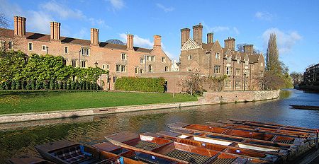
on Magdalene Bridge (built 1823), just south of Magdalene College
Magdalene College, Cambridge
Magdalene College is a constituent college of the University of Cambridge, England.The college was founded in 1428 as a Benedictine hostel, in time coming to be known as Buckingham College, before being refounded in 1542 as the College of St Mary Magdalene...
(hence the name) and just north of St John's College
St John's College, Cambridge
St John's College is a constituent college of the University of Cambridge. The college's alumni include nine Nobel Prize winners, six Prime Ministers, three archbishops, at least two princes, and three Saints....
, one of the largest University of Cambridge
University of Cambridge
The University of Cambridge is a public research university located in Cambridge, United Kingdom. It is the second-oldest university in both the United Kingdom and the English-speaking world , and the seventh-oldest globally...
colleges.
History
Magdalene Street used to be the northwestern part of Bridge Street. It developed as the northern approach to the river crossing for entering Cambridge. The first crossing was as a ford and this was built up as causeways by the RomansRoman Britain
Roman Britain was the part of the island of Great Britain controlled by the Roman Empire from AD 43 until ca. AD 410.The Romans referred to the imperial province as Britannia, which eventually comprised all of the island of Great Britain south of the fluid frontier with Caledonia...
. Eventually a bridge was built across the Cam, giving Cambridge its name. The hilltop on the northwest bank helped protect the crossing point and ensured that Cambridge became a major inland port. The area around the river area became the site for coaching inns, factories, merchants' houses, and warehouses, making use of the river’s resources and the trade at the crossing point.
When the Fens were drained in the 17th century, the river was no longer tidal. With time, the area became increasingly isolated from the main part of the town, which expanded on the other side of the crossing. The isolation and poverty of the area saved it from redevelopment in Victorian
Victorian era
The Victorian era of British history was the period of Queen Victoria's reign from 20 June 1837 until her death on 22 January 1901. It was a long period of peace, prosperity, refined sensibilities and national self-confidence...
times. Even in the 1930s, Magdalene College was too poor to carry out a plan to demolish the street up to the bridge. Subsequently, with the assistance of the College, the street was preserved as one of the oldest in Cambridge. Some of the buildings date from the 16th century and many are now listed.