

Chesterton Road, Cambridge
Encyclopedia
Cambridge
The city of Cambridge is a university town and the administrative centre of the county of Cambridgeshire, England. It lies in East Anglia about north of London. Cambridge is at the heart of the high-technology centre known as Silicon Fen – a play on Silicon Valley and the fens surrounding the...
, England
England
England is a country that is part of the United Kingdom. It shares land borders with Scotland to the north and Wales to the west; the Irish Sea is to the north west, the Celtic Sea to the south west, with the North Sea to the east and the English Channel to the south separating it from continental...
. The southwestern part of the road is known as Chesterton Lane. This links with Northampton Street
Northampton Street, Cambridge
Northampton Street is a street in the north of central Cambridge, England. It runs between Madingley Road and Queen's Road to the west and Castle Street, by Castle Hill, Chesterton Lane , and Magdalene Street to the east.Northampton Street is part of the Cambridge inner ring road and thus has...
at the junction with Castle Street
Castle Street, Cambridge
Castle Street is a street in the north of central Cambridge, England. To the southeast is a junction with Northampton Street, Magdalene Street, and Chesterton Lane...
to the northwest and Magdalene Street
Magdalene Street
Magdalene Street is a street in the north of central Cambridge, England. It runs between Castle Street, by Castle Hill, at the junction with Northampton Street and Chesterton Lane, then Chesterton Road , to the northwest and Bridge Street at the junction with Thompson's Lane to the southeast.The...
leading southeast across the River Cam
River Cam
The River Cam is a tributary of the River Great Ouse in the east of England. The two rivers join to the south of Ely at Pope's Corner. The Great Ouse connects the Cam to England's canal system and to the North Sea at King's Lynn...
into central Cambridge. At the northeastern end there is a roundabout
Roundabout
A roundabout is the name for a road junction in which traffic moves in one direction around a central island. The word dates from the early 20th century. Roundabouts are common in many countries around the world...
, linking with Elizabeth Way
Elizabeth Way, Cambridge
Elizabeth Way is a road in northeast Cambridge, England. It is designated the A1134 and forms part of Cambridge's inner ring road. At the northern end is a roundabout forming a junction with Milton Road...
(the A1134) to the south, continuing Cambridge's inner ring road
Ring road
A ring road, orbital motorway, beltway, circumferential highway, or loop highway is a road that encircles a town or city...
to the east. Half way along Chesterton Road there is a major junction with Victoria Road
Victoria Road, Cambridge
Victoria Road is a major road in the north of Cambridge, England. The road is designated the A1134. At the western end, the road links with Histon Road , Huntingdon Road , Mount Pleasant, and Castle Street.In...
northwest and Milton Road northeast (both part of the A1134) and Victoria Avenue over the Cam on Victoria Avenue Bridge
Victoria Avenue Bridge
Victoria Avenue Bridge is a single-arch road bridge across the River Cam in Cambridge, England. Immediately to the north is Chesterton Road and a major junction with Victoria Road and Milton Road....
to the south. Chesterton Lane and Chesterton Road form the northern part of the Cambridge inner ring road and thus have heavy traffic at times.
To the northwest of Chesterton Lane is Castle Hill
Castle Hill, Cambridge
Castle Hill is a hill in Cambridge, England, located in the Castle ward of the city. Cambridgeshire County Council's headquarters, Shire Hall, are located directly adjacent to Castle Hill.-History:...
, the location of the historic Cambridge Castle
Cambridge Castle
Cambridge Castle, locally also known as Castle Mound, is located in the town of the same name in Cambridgeshire, England. Originally built after the Norman conquest to control the strategically important route to the north of England, it played a role in the conflicts of the Anarchy, the First and...
. On the opposite corner at the southwestern end of Chesterton Lane is the Cambridge & County Folk Museum
Cambridge & County Folk Museum
The Cambridge & County Folk Museum is a museum located in Castle Street in central Cambridge, England. It is housed in eight rooms in the former White Horse Inn, a public house that closed in 1934. The museum presents the lives of the people of Cambridge and its surrounding area in the county of...
on Castle Street. To the southeast of Chesterton Lane is Magdalene College
Magdalene College, Cambridge
Magdalene College is a constituent college of the University of Cambridge, England.The college was founded in 1428 as a Benedictine hostel, in time coming to be known as Buckingham College, before being refounded in 1542 as the College of St Mary Magdalene...
.
In October 2000, archaeologists excavating a sewerage shaft at the corner of Chesterton Lane and Magdalene Street discovered a collection of 13th and 14th century coins. Lying in the remains of a disintegrated wooden box, on the site of what was once a house, the hoard totalled 1,805 silver pennies and nine gold coins. The cache is now in the Fitzwilliam Museum
Fitzwilliam Museum
The Fitzwilliam Museum is the art and antiquities museum of the University of Cambridge, located on Trumpington Street opposite Fitzwilliam Street in central Cambridge, England. It receives around 300,000 visitors annually. Admission is free....
.
Immediately to the south of the eastern part of Chesterton Road and running parallel for a distance is the River Cam
River Cam
The River Cam is a tributary of the River Great Ouse in the east of England. The two rivers join to the south of Ely at Pope's Corner. The Great Ouse connects the Cam to England's canal system and to the North Sea at King's Lynn...
before it splits from the road turning southeast for a short distance. In the south bank of the river here is Jesus Green
Jesus Green
Jesus Green is a park in the north of central Cambridge, England. It is located north of Jesus College, hence the name. Jesus Ditch runs through Jesus Green. On the northern edge of Jesus Green is the River Cam, with Chesterton Road on the opposite side. To the east is Victoria Avenue and beyond...
, named after Jesus College
Jesus College, Cambridge
Jesus College is a constituent college of the University of Cambridge, England.The College was founded in 1496 on the site of a Benedictine nunnery by John Alcock, then Bishop of Ely...
to the south of the Green. Jesus Lock
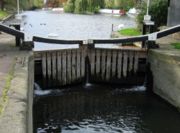
Jesus Lock
Jesus Lock is a lock on the River Cam in the north of central Cambridge, England. This is Lock No. 1 on the navigable portion of the River Cam. It was built in 1836 and is the only lock in the city. Jesus Green Lock Cottage, the former lock-keeper's cottage, is by the lock on Jesus Green...
and a footbridge on the Cam link Chesterton Road with Jesus Green for pedestrians. Close by is Jesus Green Swimming Pool
Jesus Green Swimming Pool
Jesus Green Swimming Pool is a lido situated on Jesus Green in Cambridge, England. Opened in 1923, it is one of the few remaining examples of the lidos built across the country in the 1920s — open air pools with space for activities other than swimming. Unusually, the pool is significantly longer...
, a very long lido
Lido
The Lido is an 11 km long sandbar located in Venice, northern Italy, home to about 20,000 residents. The Venice Film Festival takes place at the Lido every September.-Geography:...
.