
Cullasaja Falls
Encyclopedia
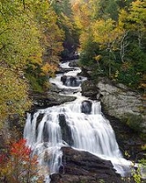
Cullasaja Falls is a waterfall
in Southwestern North Carolina
. The waterfall is located on the Cullasaja River
in the Nantahala National Forest
and is part of the Mountain Waters Scenic Byway
. Cullasaja comes from a Cherokee word meaning "honey locust place."
The height of the falls is given as 200 ft (61 m) in Kevin Adams' book, North Carolina Waterfalls and 250 ft (77.1 m) by NCWaterfalls.com. However, Google Earth gives a height (based on the elevation of the water at the top of the falls and the elevation of the plunge pool at the bottom of the falls) of 137 ft (42 m).
Waterfall
A waterfall is a place where flowing water rapidly drops in elevation as it flows over a steep region or a cliff.-Formation:Waterfalls are commonly formed when a river is young. At these times the channel is often narrow and deep. When the river courses over resistant bedrock, erosion happens...
in Southwestern North Carolina
North Carolina
North Carolina is a state located in the southeastern United States. The state borders South Carolina and Georgia to the south, Tennessee to the west and Virginia to the north. North Carolina contains 100 counties. Its capital is Raleigh, and its largest city is Charlotte...
. The waterfall is located on the Cullasaja River
Cullasaja River
The Cullasaja River is a short river located entirely in Macon County, North Carolina. It is a tributary of the Little Tennessee River , into which it flows near the county seat of Franklin. It originates to the southeast, near Highlands, the county's only other town...
in the Nantahala National Forest
Nantahala National Forest
The Nantahala National Forest, established in 1920, is a national forest located in the American state of North Carolina. The word "Nantahala" is a Cherokee word meaning "Land of the Noonday Sun." The name is appropriate as, in some spots, the sun only reaches the floors of the deep gorges of the...
and is part of the Mountain Waters Scenic Byway
Mountain Waters Scenic Byway
The Mountain Waters Scenic Byway is a two-lane highway in North Carolina, which travels through the Nantahala National Forest in Macon and Swain County, North Carolina counties. The first part of this byway follows the combined route of U.S...
. Cullasaja comes from a Cherokee word meaning "honey locust place."
Geology
The falls is the last major waterfall on the Cullasaja River. The falls is a long cascade over the course of 0.2 miles (.3 km).The height of the falls is given as 200 ft (61 m) in Kevin Adams' book, North Carolina Waterfalls and 250 ft (77.1 m) by NCWaterfalls.com. However, Google Earth gives a height (based on the elevation of the water at the top of the falls and the elevation of the plunge pool at the bottom of the falls) of 137 ft (42 m).
Visiting the Falls
It is easy to catch a glimpse of the falls as you drive by; however, getting a better view of the falls is not easy. The falls are located beside of a series of blind curves on Highway 64 with sheer rock cliffs above and below the road. There is only one small pull-off near the falls, but walking on the road puts visitors in danger of being hit by a passing vehicle.Activities
Though difficult to to reach, some use the falls as a place for leisure activities such as swimming (in the pool below) or rappelling.Nearby Falls
- Quarry FallsQuarry Falls (Macon County)Quarry Falls is a small waterfall located beside US Hwy. 64 west of Highlands, North Carolina. It is best known for the large, deep pool at the bottom and is a popular place for swimming during warm weather...
- Dry Falls
- Bridal Veil FallsBridal Veil Falls (Macon County)Bridal Veil Falls is a 45-foot waterfall located in the Nantahala National Forest, northwest of Highlands, North Carolina. With a short curve of roadway located behind the falls, it has the distinction of being the only waterfall in the state that one can drive a vehicle under.-Geology:Bridal Veil...